Texas Summer - 2014
Moderator: S2k Moderators
Forum rules

The posts in this forum are NOT official forecast and should not be used as such. They are just the opinion of the poster and may or may not be backed by sound meteorological data. They are NOT endorsed by any professional institution or STORM2K.

I was surprised to see 3.11 at the house the other night - it looked like I'd just miss them. 10-20 miles w/sw of me got nothing.
0 likes
The above post and any post by dhweather is NOT an official forecast and should not be used as such. It is just the opinion of the poster and may or may not be backed by sound meteorological data. It is NOT endorsed by any professional institution including storm2k.org. For official information, please refer to NWS products.
-
weatherdude1108
- Category 5

- Posts: 4228
- Joined: Tue Dec 13, 2011 1:04 pm
- Location: Northwest Austin/Cedar Park, TX
Going on three weeks without any rain here, coming up on this Thursday night. Had 3.5 inches a few weeks ago. Long gone from the soil. It lasted a while. My rain barrel a third full, conserving what little rain water I have left, I finally had to pull out the hose to water dry spots in the grass yesterday that have developed, being fully aware I was helping to drain Lake Travis. I was trying to water as fast and efficiently as I could, moistening and throwing compost into the cracks to loosen it up and keep from encroaching on the foundation.  Mid-upper 90s as far as the eye can see. I was hoping to avoid Summer this year. Ah well.
Now I'm wondering if El Nino will even come to fruition -- at all -- based on what I've seen with the cooling of the Pacific and virtually no atmospheric response to the previous month's warm pool. That's a different thread, but it makes me think Central Texas is cursed. I know I need to get out of the Monday funk.
 Just searching for good news on the horizon - anywhere/from anyone. Ho hum Summer fun.
Now I'm wondering if El Nino will even come to fruition -- at all -- based on what I've seen with the cooling of the Pacific and virtually no atmospheric response to the previous month's warm pool. That's a different thread, but it makes me think Central Texas is cursed.
0 likes

-
Janie2006

- Category 5
- Posts: 1329
- Joined: Mon Sep 18, 2006 3:28 pm
- Location: coastal Ms aka home of the hurricanes
Re: Texas Summer - 2014
^^ The idea is there. It's way out in voodoo land, but the idea is there. Given the overall pattern this summer I wouldn't be shocked at this point to see it happen again.
0 likes
-
SaskatchewanScreamer
Re:
Tireman4 wrote:Ntxw,
Look into your crystal ball. Any more intrusions coming south for August? Like fronts...
No he doesn't see any!
Poor Jacalyn looks pretty wet: http://www.theweathernetwork.com/news/a ... 5_29105696
I think Houston's and Texas' next cold front should come from California. Canada has had enough excitement *cough* lately.
0 likes
-
aggiecutter
- Category 5
- Posts: 1755
- Joined: Thu Oct 14, 2004 9:22 pm
- Location: Texarkana
Re: Texas Summer - 2014
View conversation Reply Retweet Favorite More
Henry Margusity @HenryMargusity 2h
Rule of thumb...August patterns tend to foretell the the winter pattern. What you see is what you get in winter.
Henry Margusity @HenryMargusity 2h
Rule of thumb...August patterns tend to foretell the the winter pattern. What you see is what you get in winter.
0 likes


Re: Texas Summer - 2014
Tireman4 wrote:Ntxw,
Look into your crystal ball. Any more intrusions coming south for August? Like fronts...
Unfortunately it looks like typical summer heat is back. There is a trough but it's centered more east, we'll have to see how Halong plays a role a little bit down the road.
aggiecutter wrote:View conversation Reply Retweet Favorite More
Henry Margusity @HenryMargusity 2h
Rule of thumb...August patterns tend to foretell the the winter pattern. What you see is what you get in winter.
I'm not sure about August, I've never found much correlation. The transition months tends to foretell the next coming season. Such as March is for spring, May is for summer, and August for fall. For winter there is a glaring correlation between October weather and the coming winter as the jet stream begins its move and pieces settle in, feedback then occurs. Typically an index (AO, NAO, EPO etc) will take dominance during this month and will drive much of weather the following season. If you notice one of our posters uses Halloween (DFW) as a precursor and it's effective. In reality you can actually expand this idea for the entire month as well.
0 likes
The above post and any post by Ntxw is NOT an official forecast and should not be used as such. It is just the opinion of the poster and may or may not be backed by sound meteorological data. It is NOT endorsed by any professional institution including Storm2k. For official information, please refer to NWS products.
Help support Storm2K!
-
Janie2006
- Category 5
- Posts: 1329
- Joined: Mon Sep 18, 2006 3:28 pm
- Location: coastal Ms aka home of the hurricanes
Re: Texas Summer - 2014
Generally good agreement between GFS and the Euro this morning about yet another trough making its way into the eastern US around Day 7. It seems to me that this would be because of tropical activity in the WPAC as well as the continued (!) warmth of the water in the NE Pacific. I'll grant, however, that this is a week out, and no one with half a brain bets the farm on a model forecast a week away!! Still, that's a consistent idea.
0 likes

Re: Texas Summer - 2014
The next 10 days look fairly redundant. The upside is the moderate temps considering what we could be getting. Mid month looks to be when we COULD see changes.
0 likes
Resident Rain Miser
I am a weather hobbyist living 3.5 miles south of Downtown Austin and in no way or fashion should anything I say concerning forecasts be taken seriously. Please check your local NWS for accurate weather forecasting and conditions.
I am a weather hobbyist living 3.5 miles south of Downtown Austin and in no way or fashion should anything I say concerning forecasts be taken seriously. Please check your local NWS for accurate weather forecasting and conditions.
-
WeatherNewbie
- Tropical Storm

- Posts: 235
- Joined: Mon Mar 22, 2010 3:42 pm
- Location: Richardson, Texas
Random heavy downpour in Dallas right now. Coming down in sheets.
0 likes
The above post is NOT an official forecast and should not be used as such. It is just the opinion of the poster and may or may not be backed by sound meteorological data. It is NOT endorsed by any professional institution including storm2k.org. For official information, please refer to NWS products.
-
high_lander
- Tropical Low

- Posts: 34
- Joined: Tue Jan 01, 2013 7:02 pm
- Location: Little Elm, TX
-
Rgv20

- S2K Supporter

- Posts: 2466
- Age: 39
- Joined: Wed Jan 05, 2011 5:42 pm
- Location: Edinburg/McAllen Tx
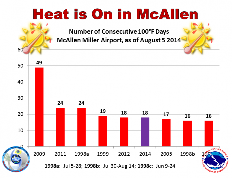
It has been toasty!!

0 likes
The following post is NOT an official forecast and should not be used as such. It is just the opinion of the poster and may or may not be backed by sound meteorological data. It is NOT endorsed by any professional institution including storm2k.org For Official Information please refer to the NHC and NWS products.
-
aggiecutter
- Category 5
- Posts: 1755
- Joined: Thu Oct 14, 2004 9:22 pm
- Location: Texarkana


-
weatherdude1108
- Category 5
- Posts: 4228
- Joined: Tue Dec 13, 2011 1:04 pm
- Location: Northwest Austin/Cedar Park, TX
I like to see a hint of any kind of change. Keeps my hopes up. 
000
FXUS64 KEWX 072010
AFDEWX
AREA FORECAST DISCUSSION
NATIONAL WEATHER SERVICE AUSTIN/SAN ANTONIO TX
310 PM CDT THU AUG 7 2014
.SHORT TERM (TONIGHT THROUGH FRIDAY NIGHT)...
COVERAGE OF AFTERNOON CU IS LESS THAN PREVIOUS DAYS AS SLIGHTLY DRIER AIR IS IN PLACE ACROSS SOUTH CENTRAL TEXAS. THE HRRR AND OTHER HIGH-RES MODELS CONTINUE TO FORECAST WAY TOO MUCH CONVECTION EACH AFTERNOON AND WILL KEEP THE FORECAST DRY FOR THE REMAINDER OF THE DAY. TOMORROW ALSO SHOULD REMAIN DRY AS PW VALUES REMAIN AROUND 1.5 TO 1.6 INCHES. THE HEAT WILL BE THE MAIN STORY WITH HIGHS IN THE UPPER 90S TO 104 ACROSS THE REGION. DEWPOINTS ACROSS
THE COASTAL PLAINS WILL ONLY MIX OUT TO THE MIDDLE TO UPPER 60S. THIS SHOULD LEAD TO HEAT INDICES TOMORROW IN THE 103 TO 105 DEGREE RANGE. WILL CONTINUE TO HIGHLIGHT THIS IN THE HWO BUT A HEAT ADVISORY IS NOT NEEDED. LOWS TONIGHT AND FRIDAY NIGHT WILL BOTTOM OUT IN THE LOWER TO UPPER 70S.
.LONG TERM (SATURDAY THROUGH THURSDAY)...
THIS WEEKEND....A WEAK UPPER LOW/TUTT WILL MOVE INTO NORTHERN MEXICO THEN MOVE NORTHWEST NEAR THE RIO GRANDE RIVER. THE FLOW AROUND THE LOW SHOULD BRING IN SLIGHTLY HIGHER MOISTURE VALUES TO THE REGION SATURDAY AND SUNDAY. THIS SHOULD ALLOW A SLIGHT CHANCE OF AFTERNOON SHOWERS AND STORMS ACROSS THE FAR SOUTHEASTERN COUNTIES. WILL ALSO SHOW SLIGHT CHANCE POPS FOR AREAS NEAR THE RIO GRANDE AS WEAK LIFT ASSOCIATED WITH THE UPPER LOW COULD CAUSE A
FEW SHOWERS AND THUNDERSTORMS. NO WIDESPREAD RAIN IS EXPECTED THIS WEEKEND.
THE FORECAST FOR THE BEGINNING OF THE WEEK IS MOSTLY THE
SAME...BUT THE MODELS ARE NOW HINTING AT A DIFFERENT PATTERN
SHAPING UP BY TUESDAY/WEDNESDAY. INSTEAD OF THE RETURN OF A RIDGE ACROSS TEXAS FOR SEVERAL DAYS. MODELS ARE NOW FORECASTING A TROUGH TO DROP INTO THE THE NORTHEASTERN CONUS BY TUESDAY. THIS WOULD ALLOW THE RIDGE TO RE-CENTER AND AMPLIFY ACROSS NEW MEXICO AND COLORADO. THE ECMWF AND GFS ARE IN FAIRLY GOOD AGREEMENT THAT A WEAK FRONT WILL MOVE INTO NORTH TEXAS TUESDAY OR TUESDAY NIGHT WHICH COULD BRING RAIN CHANCES TO MOST OF SOUTH-CENTRAL TEXAS SOMETIME IN THIS TIME FRAME. THIS SOLUTION IS ALSO SOMEWHAT SUPPORTED BY MOST OF THE GFS ENSEMBLE MEMBERS...THE NORTH AMERICAN ENSEMBLE FORECAST SYSTEM AND THE CANADIAN. THERE ARE QUESTIONS OF HOW FAR ANY POTENTIAL FRONT WILL MAKE IT AND ALSO THE BEST TIMING FOR RAIN CHANCES. WILL KEEP THE FORECAST DRY FOR NOW AS THIS IS A CHANGE FROM PREVIOUS RUNS...BUT IT BEARS WATCHING. TUESDAY AHEAD OF ANY POTENTIAL FRONT WILL BE ONE OF THE HOTTEST DAYS OF THE YEAR. THE GFS AND ECMWF ARE BOTH FORECASTING 850 TEMPS TO BE THE HIGHEST WE HAVE SEEN THIS YEAR...RANGING FROM 22 TO 25 C. MOST LOCATIONS...EXCLUDING THE HILL COUNTRY SHOULD SEE THE CENTURY MARK. WILL COOL TEMPERATURES SLIGHTLY WEDNESDAY AND THURSDAY TO ACCOUNT FOR POTENTIAL CLOUD COVER ASSOCIATED WITH A FRONT IN NORTH TEXAS.
ANOTHER TROUGH/COLD FRONT IS HINTED AT BY THE GFS AND ECMWF BEYOND THIS FORECAST PERIOD. HOWEVER...ONCE AGAIN THE MAIN TROUGH AXIS WILL BE EAST OF THE AREA AND WE WILL HAVE TO WAIT AND SEE WHAT TYPE OF IMPACTS THIS MAY HAVE ON OUR WEATHER.
HAMPSHIRE
0 likes
The preceding post is NOT an official forecast, and should not be used as such. It is only the opinion of the poster and may or may not be backed by sound meteorological data. It is NOT endorsed by any professional institution including storm2k.org. For Official Information please refer to the NHC and NWS products.
Re: Texas Summer - 2014
The pattern continues, precip in Kansas/Oklahoma, moves SE into Ark/La and eastward, Texas remains high, dry and hot.

0 likes
The above post and any post by dhweather is NOT an official forecast and should not be used as such. It is just the opinion of the poster and may or may not be backed by sound meteorological data. It is NOT endorsed by any professional institution including storm2k.org. For official information, please refer to NWS products.
Looks like August will be more of a typical August - hot and dry. I don't see significant relief in the next two weeks.
0 likes
The above post and any post by dhweather is NOT an official forecast and should not be used as such. It is just the opinion of the poster and may or may not be backed by sound meteorological data. It is NOT endorsed by any professional institution including storm2k.org. For official information, please refer to NWS products.
0 likes
The above post and any post by Ntxw is NOT an official forecast and should not be used as such. It is just the opinion of the poster and may or may not be backed by sound meteorological data. It is NOT endorsed by any professional institution including Storm2k. For official information, please refer to NWS products.
Help support Storm2K!
Help support Storm2K!
-
TheProfessor

- Professional-Met

- Posts: 3506
- Age: 29
- Joined: Tue Dec 03, 2013 10:56 am
- Location: Wichita, Kansas
-
texas1836
- Tropical Storm
- Posts: 223
- Age: 55
- Joined: Fri Aug 17, 2012 10:10 am
- Location: Ruidoso, New Mexico
Re:
Ntxw wrote::uarrow: Actually this is not entirely true. Guidance (ECMWF and GFS) are showing below normal temperatures next week as a cold front will swing on through. Core of the anomalies this time will be to the east but NW flow aloft will usher in lower 90s, which for August is manageable. Warms up again next weekend before large scale changes aloft occurs again. Rain doesn't look to good at this time.
For the next couple of days I'm showing lower 90's during the day and upper 60's in the mornings for McKinney. What do you mean by large scale change? Similar to what's coming or with a little more punch?
0 likes
Return to “USA & Caribbean Weather”
Who is online
Users browsing this forum: AnnularCane, HurricaneBelle and 70 guests