CPAC: JULIO - Post-Tropical

Moderator: S2k Moderators

Message
Author
TheStormExpert

Re: EPAC: JULIO - Hurricane

#161 Postby TheStormExpert » Thu Aug 07, 2014 7:55 pm

Ntxw wrote:
Yellow Evan wrote:
cycloneye wrote:We have another major cane!

EP, 10, 2014080800, , BEST, 0, 173N, 1384W, 100, 966, HU


Make that #5 for 2014.


Looks like NOAA's 3-6 majors forecast may end up on the low side. Unless we only get one more.

Does NOAA have a August Update for their East Pacific Hurricane forecast like they do for the Atlantic?
0 likes   

User avatar
Yellow Evan
Professional-Met
Professional-Met
Posts: 16143
Age: 27
Joined: Fri Jul 15, 2011 12:48 pm
Location: Henderson, Nevada/Honolulu, HI
Contact:

Re: EPAC: JULIO - Hurricane

#162 Postby Yellow Evan » Thu Aug 07, 2014 8:02 pm

TheStormExpert wrote:
Ntxw wrote:
Yellow Evan wrote:
Make that #5 for 2014.


Looks like NOAA's 3-6 majors forecast may end up on the low side. Unless we only get one more.

Does NOAA have a August Update for their East Pacific Hurricane forecast like they do for the Atlantic?


No.
0 likes   

User avatar
Steve820
Tropical Storm
Tropical Storm
Posts: 188
Age: 25
Joined: Sat May 17, 2014 8:04 pm
Location: Southern California
Contact:

#163 Postby Steve820 » Thu Aug 07, 2014 8:05 pm

Looks like we finally have another major hurricane according to ATCF! Now we're just waiting for NHC's 8 PM advisory to upgrade Julio to a major. And it's still looking like a minor threat to Hawaii.
0 likes   
Hurricanes are an amazing natural phenomena. While many are spiraling pits of evil that kill people or cause devastation, some are tame and stay clear of land.

I wish for you to :Bcool:

supercane
S2K Supporter
S2K Supporter
Posts: 2858
Joined: Wed Sep 16, 2009 8:27 pm

Re: EPAC: JULIO - Hurricane

#164 Postby supercane » Thu Aug 07, 2014 8:26 pm

meriland23 wrote:
hurricaneCW wrote:Luckily for Hawaii this one is going to their north otherwise I could have seen Julio as an even bigger problem than Iselle.

Don't assume. Its too close too call, little shirt here or there changes everything. They assumed iselle would near miss around this far out as well.

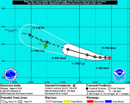
No revisionist history, please. When considering the average error, Hawaii was definitely shown as being in danger of a hit. For example, here is the 5-day track graphic from when Iselle closer to Julio's current longitude with the dot north of the Big Island representing the 96-hr forecast point:
Image
In comparison, the current forecast for Julio shows the storm north of the Big Island at around 72 hours.
Last edited by supercane on Thu Aug 07, 2014 9:50 pm, edited 1 time in total.
0 likes   

User avatar
galaxy401
Category 5
Category 5
Posts: 2419
Age: 30
Joined: Sat Aug 25, 2012 9:04 pm
Location: Casa Grande, Arizona

#165 Postby galaxy401 » Thu Aug 07, 2014 9:39 pm

Looks like it may have peaked. Cloud tops are starting to warm.
0 likes   
Got my eyes on moving right into Hurricane Alley: Florida.

supercane4867
Category 5
Category 5
Posts: 4966
Joined: Wed Nov 14, 2012 10:43 am

Re: EPAC: JULIO - Hurricane

#166 Postby supercane4867 » Thu Aug 07, 2014 9:48 pm

...JULIO BECOMES THE FOURTH MAJOR HURRICANE OF THE EASTERN PACIFIC SEASON...
...NEXT ADVISORY ISSUED BY THE CENTRAL PACIFIC HURRICANE CENTER...

8:00 PM PDT Thu Aug 7
Location: 17.4°N 139.1°W
Moving: W at 16 mph
Min pressure: 966 mb
Max sustained: 115 mph
Last edited by supercane4867 on Thu Aug 07, 2014 9:48 pm, edited 2 times in total.
0 likes   

User avatar
cycloneye
Admin
Admin
Posts: 145295
Age: 68
Joined: Thu Oct 10, 2002 10:54 am
Location: San Juan, Puerto Rico

Re: EPAC: JULIO - Hurricane

#167 Postby cycloneye » Thu Aug 07, 2014 9:48 pm

HURRICANE JULIO DISCUSSION NUMBER 17
NWS NATIONAL HURRICANE CENTER MIAMI FL EP102014
800 PM PDT THU AUG 07 2014

Despite a marginal environment, Julio has become better organized
over the past several hours with warming temperatures in the eye
and strong convection in the eyewall. Subjective and objective
Dvorak estimates from all agencies suggest that the intensity has
increased to at least 100 kt, so the initial wind speed is raised to
that value.

With few outer bands and a symmetric structure around the eye,
Julio now appears to have become an annular hurricane, much like
Iselle in the same general area a few days ago. While guidance
is generally showing a steady or quick weakening, these hurricanes
are known to be more resilent to marginal environments than most.
Since little change is expected to the SSTs or shear for the next
day or so, it makes sense to go above the model guidance at that
time with the current annular structure, and the NHC prediction is
raised from the previous one. An increase in westerly shear after
that time could cause Julio to transition into a more conventional
cyclone structure, so the intensity forecast is blended with the
previous interpolated forecast and the model consensus. At long
range, although the SSTs are forecast to rise, there could also be
an increase in shear. With the large uncertainty, little change is
made to the extended-range intensity prediction.

Julio is moving at about 280/14. There has been no change to the
forecast synoptic pattern with the hurricane expected to remain
south of the subtropical ridge for the next few days, with a
westward turn at long range due to the ridge strengthening. Track
guidance is in better agreement than the last cycle, with even
the GFDL model, formerly an outlier solution near Hawaii, shifting
northward away from the islands. The new NHC prediction is
adjusted a bit to the north at longer range, close to the model
consensus, although most of the better performing individual models
are still farther north. It should be noted that data from a NOAA
G-IV jet synoptic surveillance mission for Julio should be included
in the 0000 UTC model runs.

Julio is expected to move into the Central Pacific Hurricane
Center's area of responsibility by 0900 UTC and will issue the next
advisory on this system.

FORECAST POSITIONS AND MAX WINDS

INIT 08/0300Z 17.4N 139.1W 100 KT 115 MPH
12H 08/1200Z 17.8N 141.4W 100 KT 115 MPH
24H 09/0000Z 18.5N 144.3W 95 KT 110 MPH
36H 09/1200Z 19.4N 147.1W 85 KT 100 MPH
48H 10/0000Z 20.6N 149.9W 75 KT 85 MPH
72H 11/0000Z 22.9N 154.7W 65 KT 75 MPH
96H 12/0000Z 24.2N 159.2W 60 KT 70 MPH
120H 13/0000Z 25.0N 163.0W 60 KT 70 MPH

$$
Forecaster Blake
0 likes   
Visit the Caribbean-Central America Weather Thread where you can find at first post web cams,radars
and observations from Caribbean basin members Click Here

supercane4867
Category 5
Category 5
Posts: 4966
Joined: Wed Nov 14, 2012 10:43 am

Re: EPAC: JULIO - Hurricane

#168 Postby supercane4867 » Thu Aug 07, 2014 9:56 pm

cycloneye wrote:With few outer bands and a symmetric structure around the eye,
Julio now appears to have become an annular hurricane, much like
Iselle in the same general area a few days ago.

## ANNULAR HURRICANE INDEX (AHI) EP102014 JULIO 08/08/14 00 UTC ##
## PASSED SCREENING STEP, MIGHT BE ANNULAR, CALCULATE AHI FROM DISCRIMINANT ANALYSIS ##
## AHI= 32 (AHI OF 100 IS BEST FIT TO ANN. STRUC., 1 IS MARGINAL, 0 IS NOT ANNULAR) ##
0 likes   

User avatar
Yellow Evan
Professional-Met
Professional-Met
Posts: 16143
Age: 27
Joined: Fri Jul 15, 2011 12:48 pm
Location: Henderson, Nevada/Honolulu, HI
Contact:

#169 Postby Yellow Evan » Thu Aug 07, 2014 9:57 pm

Big shift to the north. Good news.
0 likes   

User avatar
somethingfunny
ChatStaff
ChatStaff
Posts: 3926
Age: 37
Joined: Thu May 31, 2007 10:30 pm
Location: McKinney, Texas

#170 Postby somethingfunny » Thu Aug 07, 2014 10:22 pm

It ought to be mentioned that Julio has strengthened into a major hurricane at the same longitude where Iselle weakened below major hurricane strength, so even if Julio were to decay at the same rate as Iselle (and conditions look more conducive for Julio to not weaken as quickly) it would arrive at Hawaii stronger than Iselle is.

Also don't forget that Julio doesn't have to make landfall to cause major problems. There have been a few storms which passed north of Hawaii before and they were quite damaging as well. For one thing, being on the southern side of Julio would mean lots of rainfall on the south/west slopes which are normally the drier side of the islands - Maybe more susceptible to flash flooding in areas unaccustomed to heavy rainfall, and all of it exacerbating flooding that came from Iselle.
0 likes   
I am not a meteorologist, and any posts made by me are not official forecasts or to be interpreted as being intelligent. These posts are just my opinions and are probably silly opinions.

CrazyC83
Professional-Met
Professional-Met
Posts: 34002
Joined: Tue Mar 07, 2006 11:57 pm
Location: Deep South, for the first time!

#171 Postby CrazyC83 » Thu Aug 07, 2014 10:26 pm

It will continue to be tricky this weekend in Hawaii! Even though I think the odds of another landfall aren't that high (but not zero).
0 likes   

User avatar
fci
S2K Supporter
S2K Supporter
Posts: 3324
Joined: Tue Sep 14, 2004 10:29 am
Location: Lake Worth, FL

#172 Postby fci » Fri Aug 08, 2014 12:01 am

Is there any chance of the Fujiwara Effect between Iselle and Julio?
They're about 900 miles or so apart and I think the effect is when they are about 850 miles apart. Pretty close to that.
0 likes   
Personal Forecast Disclaimer:
My posts are just my opinion and are most likely not backed by sound meteorological data. They are NOT endorsed by any professional institution or storm2k.org. For official information, please refer to the NHC and NWS products.
Bottom line is that I am just expressing my opinion!!!

User avatar
Yellow Evan
Professional-Met
Professional-Met
Posts: 16143
Age: 27
Joined: Fri Jul 15, 2011 12:48 pm
Location: Henderson, Nevada/Honolulu, HI
Contact:

Re:

#173 Postby Yellow Evan » Fri Aug 08, 2014 12:02 am

fci wrote:Is there any chance of the Fujiwara Effect between Iselle and Julio?
They're about 900 miles or so apart and I think the effect is when they are about 850 miles apart. Pretty close to that.


Doubt it, given how much Iselle was able to intensify at one point and how much Julio has.
0 likes   

TheStormExpert

#174 Postby TheStormExpert » Fri Aug 08, 2014 4:01 am

Now has maximum winds of 120mph! No change in track.
0 likes   

User avatar
somethingfunny
ChatStaff
ChatStaff
Posts: 3926
Age: 37
Joined: Thu May 31, 2007 10:30 pm
Location: McKinney, Texas

Re:

#175 Postby somethingfunny » Fri Aug 08, 2014 4:48 am

TheStormExpert wrote:Now has maximum winds of 120mph! No change in track.


Actually this is the first forecast graphic for Julio which has all of the main islands entirely outside of the cone. That doesn't mean there won't be significant effects on the storm's periphery - onshore winds where there are usually offshore winds, for one thing...

Image
0 likes   
I am not a meteorologist, and any posts made by me are not official forecasts or to be interpreted as being intelligent. These posts are just my opinions and are probably silly opinions.

User avatar
cycloneye
Admin
Admin
Posts: 145295
Age: 68
Joined: Thu Oct 10, 2002 10:54 am
Location: San Juan, Puerto Rico

Re: EPAC: JULIO - Hurricane

#176 Postby cycloneye » Fri Aug 08, 2014 4:54 am


HURRICANE JULIO DISCUSSION NUMBER 18
NWS CENTRAL PACIFIC HURRICANE CENTER HONOLULU HI EP102014
1100 PM HST THU AUG 07 2014

HURRICANE JULIO HAS ENTERED THE CENTRAL NORTH PACIFIC. SATELLITE
PRESENTATION SHOWS JULIO REMAINS WELL ORGANIZED...WITH PRONOUNCED
BANDING FEATURES REPLACING THE PREVIOUSLY DOMINANT ANNULAR
STRUCTURE. SUBJECTIVE DVORAK INTENSITY ESTIMATES RANGE FROM 4.5...BY
JTWC...TO 6.0...BY CPHC. THE UW-CIMSS ADT IS 5.7...WHILE SAB SPLIT
THE DIFFERENCE AT 5.5...OR 102 KT. THE INITIAL INTENSITY IS SET AT
105 KT FOR THIS FORECAST CYCLE...SLIGHTLY HIGHER THAN THE PREVIOUS
CYCLE BUT STILL REPRESENTING A WEAKENING OVER THE PAST 24 HOURS.

JULIO IS MOVING TOWARD THE WEST NORTHWEST ALONG THE SOUTHERN FLANK
OF A SUBTROPICAL RIDGE EXTENDING ROUGHLY FROM 35N140W THROUGH
38N180W. MODEL TRACK GUIDANCE REMAINS RATHER TIGHTLY PACKED THROUGH
48 HOURS...AND THE FORECAST TRACK HAS CHANGED LITTLE THROUGH THAT
TAU AS IT FOLLOWS TVCN CONSENSUS. HOWEVER...TVCN BEGINS TO DEPART
RATHER SIGNIFICANTLY FROM EARLIER RUNS AT TAU BEYOND 48
HOURS...LIKELY RESPONDING TO A RADICAL RIGHTWARD GFS SWING TO THE
NORTH AT LONG RANGE. AS A RESULT...THE FORECAST TRACK BEGINS TO
PARALLEL ECMWF INSTEAD OF TVCN BEYOND 48 HOURS...ALTHOUGH IT HAS
BEEN ALTERED A BIT NORTH OF THE PREVIOUS FORECAST TRACK TO MAINTAIN
SMOOTHNESS AND CONSISTENCY. IT IS IMPORTANT TO NOTE THAT...WHILE THE
FORECAST TRACK TAKES JULIO PARALLEL TO AND NORTH OF THE MAIN
HAWAIIAN ISLANDS...INTERESTS THERE SHOULD WATCH DEVELOPMENTS WITH
THIS SYSTEM CLOSELY.

THE INTENSITY FORECAST IS UNCHANGED FROM THE PREVIOUS
FORECAST...EXCEPT FOR THE HIGHER INITIAL INTENSITY. SHIPS GUIDANCE
SHOWS GRADUAL WEAKENING THROUGH 120 HOURS...WITH SST BEING THE MOST
SIGNIFICANT WEAKENING FACTOR. WHILE SHEAR IS EXPECTED TO STRENGTHEN
AFTER 24 HOURS AS JULIO APPROACHES AN UPPER TROUGH NORTHWEST OF THE
MAIN HAWAIIAN ISLANDS...THE SHEAR MAGNITUDE IS NEVER MORE THAN 11 TO
13 KT. JULIO IS FORECAST TO REMAIN A MINIMAL HURRICANE AT 72
HOURS...THEN REMAIN A STRONG TROPICAL STORM FROM 72 TO 120 HOURS.

FORECAST POSITIONS AND MAX WINDS

INIT 08/0900Z 17.8N 140.4W 105 KT 120 MPH
12H 08/1800Z 18.2N 142.6W 100 KT 115 MPH
24H 09/0600Z 19.1N 145.5W 95 KT 110 MPH
36H 09/1800Z 20.1N 148.3W 85 KT 100 MPH
48H 10/0600Z 21.2N 150.9W 80 KT 90 MPH
72H 11/0600Z 23.7N 155.7W 65 KT 75 MPH
96H 12/0600Z 25.7N 159.9W 60 KT 70 MPH
120H 13/0600Z 27.2N 164.2W 60 KT 70 MPH

$$
FORECASTER POWELL
0 likes   
Visit the Caribbean-Central America Weather Thread where you can find at first post web cams,radars
and observations from Caribbean basin members Click Here

User avatar
meriland23
Category 5
Category 5
Posts: 1239
Age: 37
Joined: Mon Aug 29, 2011 9:29 pm

Re: EPAC: JULIO - Hurricane

#177 Postby meriland23 » Fri Aug 08, 2014 5:16 am

What do you think are the chances this hurricane will actually make landfall?
0 likes   
The posts in this forum are NOT official forecast and should not be used as such. They are just the opinion of the poster and may or may not be backed by sound meteorological data. They are NOT endorsed by any professional institution or storm2k.org. For official information, please refer to the NHC and NWS products.

WeatherGuesser
Category 5
Category 5
Posts: 2672
Joined: Tue Jun 29, 2010 6:46 am

#178 Postby WeatherGuesser » Fri Aug 08, 2014 6:11 am

Iselle ended up a bit further south than expected, so only time will tell if Julio does the same and affects any of the islands.
0 likes   

User avatar
cycloneye
Admin
Admin
Posts: 145295
Age: 68
Joined: Thu Oct 10, 2002 10:54 am
Location: San Juan, Puerto Rico

Re: CPAC: JULIO - Hurricane

#179 Postby cycloneye » Fri Aug 08, 2014 8:16 am

12z Best Track down to 90kts.

EP, 10, 2014080812, , BEST, 0, 180N, 1412W, 90, 966, HU
0 likes   
Visit the Caribbean-Central America Weather Thread where you can find at first post web cams,radars
and observations from Caribbean basin members Click Here

User avatar
Yellow Evan
Professional-Met
Professional-Met
Posts: 16143
Age: 27
Joined: Fri Jul 15, 2011 12:48 pm
Location: Henderson, Nevada/Honolulu, HI
Contact:

#180 Postby Yellow Evan » Fri Aug 08, 2014 8:19 am

Yet pressure in only up 4 mbar.
0 likes   


Return to “2014”

Who is online

Users browsing this forum: No registered users and 1 guest