ENSO Updates (2007 thru 2023)
Moderator: S2k Moderators
Forum rules

The posts in this forum are NOT official forecasts and should not be used as such. They are just the opinion of the poster and may or may not be backed by sound meteorological data. They are NOT endorsed by any professional institution or STORM2K. For official information, please refer to products from the National Hurricane Center and National Weather Service.
-
xtyphooncyclonex

- Category 5

- Posts: 3891
- Age: 24
- Joined: Sat Dec 08, 2012 9:07 am
- Location: Cebu City
- Contact:
Let's see what would happen if the MJO arrives. The major climate model CFSv2 (the first to predict weakening and dissipation of the original record-breaking warm pool) currently shows the new warm pool rapidly growing in size and warming which it shows fueling a moderate-to-strong El Niño.
0 likes
REMINDER: My opinions that I, or any other NON Pro-Met in this forum, are unofficial. Please do not take my opinions as an official forecast and warning. I am NOT a meteorologist. Following my forecasts blindly may lead to false alarm, danger and risk if official forecasts from agencies are ignored.
-
dexterlabio
- Category 5
- Posts: 3506
- Joined: Sat Oct 24, 2009 11:50 pm
Re: ENSO Updates
NDG wrote:Just looking ahead. Cool subsurface pool heading towards Niño 1+2 while Niño 3.4 & 4 start warming up.
Now that the SOI seems to finally stay negative we should see the central Pacific maintain some warmth, IMO.
We have yet to see if there will be weaker or stronger westerlies in the coming weeks and months. Stronger WWB's would transport more warmth well into the eastern Pacific (east Nino 3 and Nino 1+2 regions)...thus having a traditional type of Nino.. weaker westerlies could only transport warmth into the central Pacific.
IMO it will all depend on the MJO, if it will return to the Pacific with stronger signal and faster progression.
0 likes
Personal Forecast Disclaimer:
The posts in this forum are NOT official forecast and should not be used as such. They are just the opinion of the poster and may or may not be backed by sound meteorological data. They are NOT endorsed by any professional institution or storm2k.org. For official information, please refer to the NHC and NWS products.
The posts in this forum are NOT official forecast and should not be used as such. They are just the opinion of the poster and may or may not be backed by sound meteorological data. They are NOT endorsed by any professional institution or storm2k.org. For official information, please refer to the NHC and NWS products.
-
somethingfunny

- ChatStaff

- Posts: 3926
- Age: 37
- Joined: Thu May 31, 2007 10:30 pm
- Location: McKinney, Texas
We can put stock into all those maps of temperature anomalies that only show certain depth levels of the ocean or believe the daily meanderings of computer-generated SOI numbers, but to me it's pretty obvious that we have an El Nino going on, sometimes the proof is right in front of you:

I may just be simplifying things too much but, this just doesn't happen in neutral years.
I may just be simplifying things too much but, this just doesn't happen in neutral years.
0 likes
I am not a meteorologist, and any posts made by me are not official forecasts or to be interpreted as being intelligent. These posts are just my opinions and are probably silly opinions.
-
dexterlabio
- Category 5
- Posts: 3506
- Joined: Sat Oct 24, 2009 11:50 pm
^I agree. This is a very rare and amazing feat even for an El Nino year... we don't see hurricanes travelling from EPAC to WPAC often, moreso hurricaneS threatening Hawaii all in one year...
0 likes
Personal Forecast Disclaimer:
The posts in this forum are NOT official forecast and should not be used as such. They are just the opinion of the poster and may or may not be backed by sound meteorological data. They are NOT endorsed by any professional institution or storm2k.org. For official information, please refer to the NHC and NWS products.
The posts in this forum are NOT official forecast and should not be used as such. They are just the opinion of the poster and may or may not be backed by sound meteorological data. They are NOT endorsed by any professional institution or storm2k.org. For official information, please refer to the NHC and NWS products.
-
CaliforniaResident
- Tropical Storm

- Posts: 215
- Joined: Fri Feb 21, 2014 1:47 pm
Re: ENSO Updates
This summer screams "EL NINO" to me although the models are showing that we may fade to neutral by fall. We've experienced an extremely rare phenomenon in the L.A. area this summer. Anyone want to take a stab and guess what it is?(hint-it's something that's very common in the Eastern part of the U.S.)
0 likes
-
Yellow Evan

- Professional-Met

- Posts: 16240
- Age: 27
- Joined: Fri Jul 15, 2011 12:48 pm
- Location: Henderson, Nevada/Honolulu, HI
- Contact:
Re: ENSO Updates
CaliforniaResident wrote:This summer screams "EL NINO" to me although the models are showing that we may fade to neutral by fall. We've experienced an extremely rare phenomenon in the L.A. area this summer. Anyone want to take a stab and guess what it is?(hint-it's something that's very common in the Eastern part of the U.S.)
Rain.
What models show it fading by fall?
0 likes
-
CaliforniaResident
- Tropical Storm
- Posts: 215
- Joined: Fri Feb 21, 2014 1:47 pm
Re: ENSO Updates
Yellow Evan wrote:CaliforniaResident wrote:This summer screams "EL NINO" to me although the models are showing that we may fade to neutral by fall. We've experienced an extremely rare phenomenon in the L.A. area this summer. Anyone want to take a stab and guess what it is?(hint-it's something that's very common in the Eastern part of the U.S.)
Rain.
What models show it fading by fall?
specifically, a summer thunderstorm (one actually on the beach itself killing one and injuring several others which has never happened here). We had one on the beach in July and also some light but significant (by L.A. standards) accumulation this past weekend
L.A. gets nearly all of it's measly 12 inches of rain a year from November through April.
Rain in late spring and early fall is unusual
Rain in mid-summer is almost unheard of in L.A. proper (although the mountains and deserts usually get a few storms during the monsoons).
I came across rumors the warm pool was fading (we've had warmer than normal SST all summer here) and was going to fade to neutral this fall (or a weak El Nino).
0 likes
-
Yellow Evan
- Professional-Met
- Posts: 16240
- Age: 27
- Joined: Fri Jul 15, 2011 12:48 pm
- Location: Henderson, Nevada/Honolulu, HI
- Contact:
Re: ENSO Updates
CaliforniaResident wrote:Yellow Evan wrote:CaliforniaResident wrote:This summer screams "EL NINO" to me although the models are showing that we may fade to neutral by fall. We've experienced an extremely rare phenomenon in the L.A. area this summer. Anyone want to take a stab and guess what it is?(hint-it's something that's very common in the Eastern part of the U.S.)
Rain.
What models show it fading by fall?
specifically, a summer thunderstorm (one actually on the beach itself killing one and injuring several others which has never happened here). We had one on the beach in July and also some light but significant (by L.A. standards) accumulation this past weekend
L.A. gets nearly all of it's measly 12 inches of rain a year from November through April.
Rain in late spring and early fall is unusual
Rain in mid-summer is almost unheard of in L.A. proper (although the mountains and deserts usually get a few storms during the monsoons).
I came across rumors the warm pool was fading (we've had warmer than normal SST all summer here) and was going to fade to neutral this fall (or a weak El Nino).
That rumor is true, but we have a new warm poor building.
The warmer SST's is due to the +PDO signal.
0 likes


Re: ENSO Updates
Posted by Macrocane in one of the active CPAC/EPAC threads. Worth reposting here. Those raw westerly winds near the dateline (hello new warm-pool) certainly doesn't hurt the activity. MJO? Who needs it!

0 likes
The above post and any post by Ntxw is NOT an official forecast and should not be used as such. It is just the opinion of the poster and may or may not be backed by sound meteorological data. It is NOT endorsed by any professional institution including Storm2k. For official information, please refer to NWS products.
Help support Storm2K!
-
cycloneye

- Admin

- Posts: 149443
- Age: 69
- Joined: Thu Oct 10, 2002 10:54 am
- Location: San Juan, Puerto Rico
Re: CPC 8/7/14 update=El Nino % down to 65% - Weak El Nino
Climate Prediction Center August update
They now predict Weak El Nino by the fall thru early Winter.Not forecasting a Moderate to Strong one.
Over the last month, model forecasts have slightly delayed the El Niño onset, with most models now indicating the onset during July-September, with the event continuing into early 2015 (Fig. 6). A strong El Niño is not favored in any of the ensemble averages, and slightly more models call for a weak event rather than a moderate event. At this time, the consensus of forecasters expects El Niño to emerge during August-October and to peak at weak strength during the late fall and early winter (3-month values of the Niño-3.4 index between 0.5oC and 0.9oC). The chance of El Niño has decreased to about 65% during the Northern Hemisphere fall and early winter (click CPC/IRI consensus forecast for the chance of each outcome).
http://www.cpc.ncep.noaa.gov/products/a ... odisc.html
0 likes
Visit the Caribbean-Central America Weather Thread where you can find at first post web cams,radars
and observations from Caribbean basin members Click Here
and observations from Caribbean basin members Click Here
-
'CaneFreak

- Category 5
- Posts: 1487
- Joined: Mon Jun 05, 2006 10:50 am
- Location: New Bern, NC
-
curtadams
- S2K Supporter

- Posts: 1122
- Joined: Sun Aug 28, 2005 7:57 pm
- Location: Orange, California
- Contact:
Re: ENSO Updates
The models predicting an El Nino must already be implicitly predicting another Kelvin wave with winds to drive it across the Pacific. We certainly won't get an El Nino just with the rapidly fading warm pool we've got in the East Pacific now.
0 likes
-
xtyphooncyclonex
- Category 5
- Posts: 3891
- Age: 24
- Joined: Sat Dec 08, 2012 9:07 am
- Location: Cebu City
- Contact:
Re: ENSO Updates
curtadams wrote:The models predicting an El Nino must already be implicitly predicting another Kelvin wave with winds to drive it across the Pacific. We certainly won't get an El Nino just with the rapidly fading warm pool we've got in the East Pacific now.
Are you aware of the rapidly growing warm pool which the models were consistent about? The dissipation of the original warm pool was forecast by CFSv2 earlier this year, followed by growth of another warm pool which triggers the Niño.
0 likes
REMINDER: My opinions that I, or any other NON Pro-Met in this forum, are unofficial. Please do not take my opinions as an official forecast and warning. I am NOT a meteorologist. Following my forecasts blindly may lead to false alarm, danger and risk if official forecasts from agencies are ignored.

Re: ENSO Updates
I agree with the latest CPC forecast, a weak El Nino at this time looks more likely if not a low end moderate one.
0 likes
If the TAO buoys are trusted, we have a good sized warm pool now below the surface across the Pacific. At the surface Nino 3 and 1.2 have warmed recently while 3.4 remains stubbornly lowest of the bunch however it too is warming. 1, even some 2C anomalies are appearing north of the equator between 0 and 5N around 120W
0 likes
The above post and any post by Ntxw is NOT an official forecast and should not be used as such. It is just the opinion of the poster and may or may not be backed by sound meteorological data. It is NOT endorsed by any professional institution including Storm2k. For official information, please refer to NWS products.
Help support Storm2K!
Help support Storm2K!
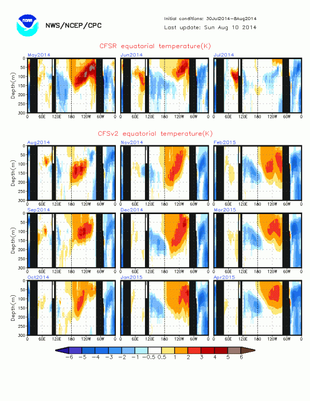
The reason why I agree with the CPC about now calling for only a weak El Nino to low end moderate by the Fall because if you look at the CFSv2 subsurface forecast, which many of you are giving credit for forecasting the current cool pool forecast surfacing in the eastern and central Pacific, it is forecasting the next subsurface warm pool to be not nothing close as warm as the warm pool earlier in the Spring.
0 likes
Re: ENSO Updates
Haven't posted to maps in awhile. Here are some of the latest.


MEI*
2014 -.318 -.269 -.017 .152 .932 .878 .815
*Here we attempt to monitor ENSO by basing the Multivariate ENSO Index (MEI) on the six main observed variables over the tropical Pacific. These six variables are: sea-level pressure (P), zonal (U) and meridional (V) components of the surface wind, sea surface temperature (S), surface air temperature (A), and total cloudiness fraction of the sky (C). These observations have been collected and published in ICOADS for many years. The MEI is computed separately for each of twelve sliding bi-monthly seasons (Dec/Jan, Jan/Feb,..., Nov/Dec). After spatially filtering the individual fields into clusters (Wolter, 1987), the MEI is calculated as the first unrotated Principal Component (PC) of all six observed fields combined. This is accomplished by normalizing the total variance of each field first, and then performing the extraction of the first PC on the co-variance matrix of the combined fields (Wolter and Timlin, 1993). In order to keep the MEI comparable, all seasonal values are standardized with respect to each season and to the 1950-93 reference period.
0 likes
The above post and any post by Ntxw is NOT an official forecast and should not be used as such. It is just the opinion of the poster and may or may not be backed by sound meteorological data. It is NOT endorsed by any professional institution including Storm2k. For official information, please refer to NWS products.
Help support Storm2K!
Help support Storm2K!
-
dexterlabio
- Category 5
- Posts: 3506
- Joined: Sat Oct 24, 2009 11:50 pm
Re: ENSO Updates
NDG wrote:The reason why I agree with the CPC about now calling for only a weak El Nino to low end moderate by the Fall because if you look at the CFSv2 subsurface forecast, which many of you are giving credit for forecasting the current cool pool forecast surfacing in the eastern and central Pacific, it is forecasting the next subsurface warm pool to be not nothing close as warm as the warm pool earlier in the Spring.
that subsurface warm pool on the forecast looks decent enough for a blend of 2006 or 2009 El Nino this year.not sure if it will be an eastern or Modoki...
0 likes
Personal Forecast Disclaimer:
The posts in this forum are NOT official forecast and should not be used as such. They are just the opinion of the poster and may or may not be backed by sound meteorological data. They are NOT endorsed by any professional institution or storm2k.org. For official information, please refer to the NHC and NWS products.
The posts in this forum are NOT official forecast and should not be used as such. They are just the opinion of the poster and may or may not be backed by sound meteorological data. They are NOT endorsed by any professional institution or storm2k.org. For official information, please refer to the NHC and NWS products.
Re: ENSO Updates
All Nino Regions have warmed up during the past week, looks like Nino 3.4 is now up to near 0 deg C.
0 likes
Per the weekly indices, Nino 3.4 is at 0C. Nino 1.2 warmed up to 1.2C, nino 3 to 0.4C, and nino 4 to 0.5C
0 likes
The above post and any post by Ntxw is NOT an official forecast and should not be used as such. It is just the opinion of the poster and may or may not be backed by sound meteorological data. It is NOT endorsed by any professional institution including Storm2k. For official information, please refer to NWS products.
Help support Storm2K!
Help support Storm2K!
Who is online
Users browsing this forum: No registered users and 424 guests