Global model runs discussion
Moderator: S2k Moderators

-
Hurricaneman

- Category 5

- Posts: 7404
- Age: 45
- Joined: Tue Aug 31, 2004 3:24 pm
- Location: central florida
Re:
Alyono wrote:EC does show a TD/weak TS moving through the islands in about 7-8 days. It quickly dissipates in the eastern Caribbean
would probably still need to be watched as there is less sinking motion in the Caribbean
The posts in this forum are NOT official forecast and should not be used as such. They are just the opinion of the poster and may or may not be backed by sound meteorological data. They are NOT endorsed by any professional institution or storm2k.org. For official information, please refer to the NHC and NWS products.
0 likes

Re:
Alyono wrote:EC does show a TD/weak TS moving through the islands in about 7-8 days. It quickly dissipates in the eastern Caribbean
Time to start paying attention to the euro to see if it becomes consistent with last night's solution.
0 likes
-
gatorcane

- S2K Supporter

- Posts: 23708
- Age: 48
- Joined: Sun Mar 13, 2005 3:54 pm
- Location: Boca Raton, FL
ECMWF finally shows an Atlantic hurricane it looks like in the 12Z run...I believe it is developing pouch 17L and I posted the graphic in that thread.
Last edited by gatorcane on Sat Aug 16, 2014 2:04 pm, edited 1 time in total.
0 likes

Re: Global Model Runs Discussion
Odd switch from last year, Euro is showing one, maybe two systems, while the GFS is showing nothing; I'm getting the feeling that the GFS is having the opposite problem now as it did poorly with all three systems so far this year.
0 likes
The above post is not official and should not be used as such. It is the opinion of the poster and may or may not be backed by sound meteorological data. It is not endorsed by any professional institution or storm2k.org. For official information, please refer to the NHC and NWS products.
-
Fego

- S2K Supporter
- Posts: 767
- Age: 66
- Joined: Sun Apr 18, 2004 7:58 pm
- Location: San Juan, Puerto Rico
- Contact:
Re: Global Model Runs Discussion
UKMT 12utc run is as bullish as the 0z ECMWF. I guess that is one of the reasons why the NHC rose to 30% the five days outlook.
NEW TROPICAL STORM FORECAST TO DEVELOP AFTER 48 HOURS
FORECAST POSITION AT T+ 48 : 12.2N 39.2W
VERIFYING TIME POSITION STRENGTH TENDENCY
-------------- -------- -------- --------
12UTC 19.08.2014 12.2N 39.2W WEAK
00UTC 20.08.2014 14.4N 41.0W WEAK WEAKENING SLIGHTLY
12UTC 20.08.2014 14.9N 45.2W WEAK LITTLE CHANGE
00UTC 21.08.2014 14.8N 50.0W WEAK LITTLE CHANGE
12UTC 21.08.2014 15.3N 53.8W WEAK LITTLE CHANGE
00UTC 22.08.2014 15.7N 57.3W WEAK LITTLE CHANGE
12UTC 22.08.2014 16.0N 60.6W WEAK LITTLE CHANGE
00UTC 23.08.2014 16.6N 63.5W WEAK INTENSIFYING SLIGHTLY
12UTC 23.08.2014 17.7N 65.6W MODERATE INTENSIFYING SLIGHTLY
0 likes
Go Giants! Go Niners! Go Warriors!
-
tolakram
- Admin

- Posts: 20170
- Age: 62
- Joined: Sun Aug 27, 2006 8:23 pm
- Location: Florence, KY (name is Mark)
Re: Global Model Runs Discussion
18Z GFS has something forming in 60 hours, and holds onto a weak storm through 190.


0 likes
M a r k
- - - - -
Join us in chat: Storm2K Chatroom Invite. Android and IOS apps also available.
The posts in this forum are NOT official forecasts and should not be used as such. Posts are NOT endorsed by any professional institution or STORM2K.org. For official information and forecasts, please refer to NHC and NWS products.
-
gatorcane
- S2K Supporter
- Posts: 23708
- Age: 48
- Joined: Sun Mar 13, 2005 3:54 pm
- Location: Boca Raton, FL
Re:
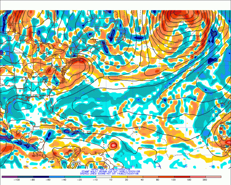
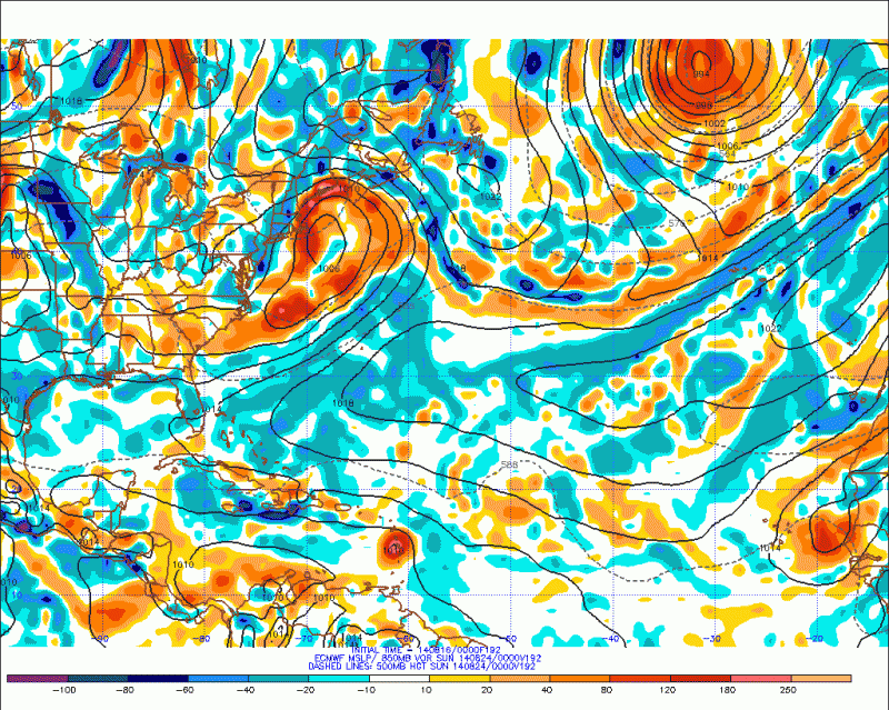
The ECMWF is showing no tropical development in the Atlantic that would threaten the US or Caribbean islands through 240 hours (10 days). Look at the long-wave pattern at the end at day 10 with the usual trough over Eastern North America and a big ridge out west - seems like this long-wave pattern doesn't want to break!

0 likes

Re: Global Model Runs Discussion
TheStormExpert wrote:Riptide wrote:Why would you want that, Winter in Florida is boring as all get out....lol. I know because I lived there for 9 years. It's also very dry during that time of the year.
Never said I wanted winter. Just want this dreadfully dull and boring season to end.
Personally I'm not even close to being ready for winter, feels like summer just started.
Can you take this to another thread? Nobody wants to here how bored you are.
Back on topic:
I don't know which pouch this is but 30-32W is where the action is starting to heat up. The voriticity has strengthened into that area and the best spin is going on there right now. The mid level spin is slightly off to the west of the low level.
http://rammb.cira.colostate.edu/ramsdis/online/loop.asp?data_folder=tropical/tropical_ge_4km_visir2_floater_1&width=640&height=480&number_of_images_to_display=12
850mb

0 likes
The following post is NOT an official forecast and should not be used as such. It is just the opinion of the poster and may or may not be backed by sound meteorological data. It is NOT endorsed by any professional institution including storm2k.org For Official Information please refer to the NHC and NWS products.
-
cycloneye

- Admin
- Posts: 148990
- Age: 69
- Joined: Thu Oct 10, 2002 10:54 am
- Location: San Juan, Puerto Rico
Re: Global Model Runs Discussion
Moved the winter posts to this thread at Winter Forum so we can post the model runs and not turn off-topic.
0 likes
Visit the Caribbean-Central America Weather Thread where you can find at first post web cams,radars
and observations from Caribbean basin members Click Here
and observations from Caribbean basin members Click Here


Re: Global Model Runs Discussion
UKMET not giving up instead it has it stronger.... We will see this is a good test after the upgrade.
12z UKMET
NEW TROPICAL STORM FORECAST TO DEVELOP AFTER 18 HOURS
FORECAST POSITION AT T+ 18 : 12.0N 36.9W
VERIFYING TIME POSITION STRENGTH TENDENCY
-------------- -------- -------- --------
12UTC 19.08.2014 12.8N 37.2W WEAK INTENSIFYING SLIGHTLY
00UTC 20.08.2014 14.3N 40.4W WEAK WEAKENING SLIGHTLY
12UTC 20.08.2014 14.9N 44.3W WEAK WEAKENING SLIGHTLY
00UTC 21.08.2014 BELOW TROPICAL STORM STRENGTH
NEW TROPICAL STORM FORECAST TO DEVELOP AFTER 54 HOURS
FORECAST POSITION AT T+ 54 : 11.6N 52.9W
VERIFYING TIME POSITION STRENGTH TENDENCY
-------------- -------- -------- --------
00UTC 21.08.2014 12.2N 52.4W WEAK LITTLE CHANGE
12UTC 21.08.2014 13.5N 54.0W WEAK LITTLE CHANGE
00UTC 22.08.2014 15.9N 57.3W WEAK LITTLE CHANGE
12UTC 22.08.2014 15.7N 61.1W WEAK INTENSIFYING SLIGHTLY
00UTC 23.08.2014 17.0N 64.1W WEAK LITTLE CHANGE
12UTC 23.08.2014 17.7N 66.4W MODERATE INTENSIFYING SLIGHTLY
00UTC 24.08.2014 19.5N 68.5W MODERATE INTENSIFYING RAPIDLY
12UTC 24.08.2014 21.3N 70.1W STRONG INTENSIFYING RAPIDLY
0 likes
The following post is NOT an official forecast and should not be used as such. It is just the opinion of the poster and may or may not be backed by sound meteorological data. It is NOT endorsed by any professional institution including storm2k.org For Official Information please refer to the NHC and NWS products.


Re: Global Model Runs Discussion
Wow direct hit on Hispanola from the UKMET. Doesn't the UKMET have the bext track record for cyclogenesis of all global models?
0 likes
-
gatorcane
- S2K Supporter
- Posts: 23708
- Age: 48
- Joined: Sun Mar 13, 2005 3:54 pm
- Location: Boca Raton, FL
Re: Global Model Runs Discussion
ronjon wrote:Wow direct hit on Hispanola from the UKMET. Doesn't the UKMET have the bext track record for cyclogenesis of all global models?
It has been quite a reliable model in the past but it recently took a pretty major SW upgrade.
0 likes
Who is online
Users browsing this forum: No registered users and 31 guests