Tropical Wave east of Lesser Antilles (Is Invest 96L)

This is the general tropical discussion area. Anyone can take their shot at predicting a storms path.

Moderator: S2k Moderators

Forum rules

The posts in this forum are NOT official forecasts and should not be used as such. They are just the opinion of the poster and may or may not be backed by sound meteorological data. They are NOT endorsed by any professional institution or STORM2K. For official information, please refer to products from the National Hurricane Center and National Weather Service.

Help Support Storm2K
Message
Author
User avatar
gatorcane
S2K Supporter
S2K Supporter
Posts: 23691
Age: 47
Joined: Sun Mar 13, 2005 3:54 pm
Location: Boca Raton, FL

Re: Tropical Wave West of CV Islands (Pouch 017L)

#101 Postby gatorcane » Sat Aug 16, 2014 9:13 pm

SFLcane wrote:Its got some pretty good spin to it but may choke in sinking air near by.
http://rammb.cira.colostate.edu/ramsdis ... display=12

Good loop, thanks for sharing. From what I can see, popcorn convection is increasing around the "llc" tonight...this is a good sign as it looks to be fighting the SAL.

Also there is a bouy out there near this pouch and it is reporting light winds out of the west the past day or so:

http://www.ndbc.noaa.gov/station_page.php?station=41026
Last edited by gatorcane on Sat Aug 16, 2014 9:19 pm, edited 1 time in total.
0 likes   

TheStormExpert

#102 Postby TheStormExpert » Sat Aug 16, 2014 9:19 pm

:uarrow: Still has a ways to go but making decent progress IMO for a wave traversing through hostile conditions.
0 likes   

TheStormExpert

#103 Postby TheStormExpert » Sat Aug 16, 2014 9:22 pm

Notice the area around this wave was trying to gradually moisten up, but has since been stabilizing again(clouds are waning).

Image
0 likes   

User avatar
Hurricaneman
Category 5
Category 5
Posts: 7351
Age: 45
Joined: Tue Aug 31, 2004 3:24 pm
Location: central florida

Re: Tropical Wave West of CV Islands (Pouch 017L)

#104 Postby Hurricaneman » Sat Aug 16, 2014 9:53 pm

This is going to have to be watched especially those in the NE windward islands, Puerto Rico and Hispaniola first but beyond that is anyone's guess

The posts in this forum are NOT official forecast and should not be used as such. They are just the opinion of the poster and may or may not be backed by sound meteorological data. They are NOT endorsed by any professional institution or storm2k.org. For official information, please refer to the NHC and NWS products
0 likes   

floridasun78
Category 5
Category 5
Posts: 3755
Joined: Sun May 17, 2009 10:16 pm
Location: miami fl

Re: Tropical Wave West of CV Islands (Pouch 017L)

#105 Postby floridasun78 » Sun Aug 17, 2014 12:43 am

TROPICAL WEATHER OUTLOOK
NWS NATIONAL HURRICANE CENTER MIAMI FL
200 AM EDT SUN AUG 17 2014

For the North Atlantic...Caribbean Sea and the Gulf of Mexico:

1. A broad low pressure area located about 1000 miles west-southwest
of the Cape Verde Islands is producing disorganized cloudiness and
showers. Some gradual development of this system is possible during
the next few days while it begins to move slowly westward across the
central tropical Atlantic.
* Formation chance through 48 hours...low...10 percent.
* Formation chance through 5 days...low...20 percent.

Forecaster Cangialosi
0 likes   

Alyono
Professional-Met
Professional-Met
Posts: 6961
Joined: Fri Apr 26, 2013 3:52 pm
Location: Texas Coast

#106 Postby Alyono » Sun Aug 17, 2014 3:53 am

and the EC now, while still briefly developing this, rapidly weakens it as it approaches the Caribbean. More reasonable solution
0 likes   

ninel conde

#107 Postby ninel conde » Sun Aug 17, 2014 5:40 am

air is just too dry.
0 likes   

User avatar
cycloneye
Admin
Admin
Posts: 145277
Age: 68
Joined: Thu Oct 10, 2002 10:54 am
Location: San Juan, Puerto Rico

Re: Tropical Wave West of CV Islands (Pouch 017L)

#108 Postby cycloneye » Sun Aug 17, 2014 6:20 am

TROPICAL WEATHER OUTLOOK
NWS NATIONAL HURRICANE CENTER MIAMI FL
800 AM EDT SUN AUG 17 2014

For the North Atlantic...Caribbean Sea and the Gulf of Mexico:

A broad low pressure area located midway between the Lesser Antilles
and the Cape Verde Islands is producing disorganized cloudiness and
showers. Some gradual development of this system is possible during
the next few days while it moves slowly westward across the central
tropical Atlantic.
* Formation chance through 48 hours...low...10 percent.
* Formation chance through 5 days...low...20 percent.

$$
Forecaster Avila
0 likes   
Visit the Caribbean-Central America Weather Thread where you can find at first post web cams,radars
and observations from Caribbean basin members Click Here

Alyono
Professional-Met
Professional-Met
Posts: 6961
Joined: Fri Apr 26, 2013 3:52 pm
Location: Texas Coast

#109 Postby Alyono » Sun Aug 17, 2014 8:45 am

In the unlikely event that anything does form, it likely will be very weak and recurve east of Bermuda. Not even any low level ridging to force this to the west
0 likes   

User avatar
cycloneye
Admin
Admin
Posts: 145277
Age: 68
Joined: Thu Oct 10, 2002 10:54 am
Location: San Juan, Puerto Rico

Re: Tropical Wave midway between CV Islands and Lesser Antilles

#110 Postby cycloneye » Sun Aug 17, 2014 10:34 am

There is some competition going on between small monsoon gyres,one around 12N-39W and another at 12N-28W. Maybe this is what have the models not being too clear on development and track. IMO,the one at 12N-39W looks like the dominant right now but that could change.

Image
0 likes   
Visit the Caribbean-Central America Weather Thread where you can find at first post web cams,radars
and observations from Caribbean basin members Click Here

User avatar
SFLcane
S2K Supporter
S2K Supporter
Posts: 10163
Age: 47
Joined: Sat Jun 05, 2010 1:44 pm
Location: Lake Worth Florida

Re: Tropical Wave midway between CV Islands and Lesser Antilles

#111 Postby SFLcane » Sun Aug 17, 2014 10:38 am

Post via twitter @Michael Ventrice

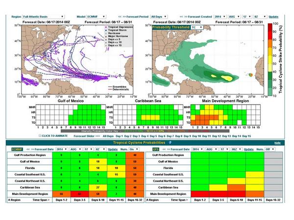
Expect probabilities to increase w/ Atlantic MDR invest. EC ENS shows increased risk for Southeastern U.S. landfall.

Image
0 likes   

User avatar
blp
Category 5
Category 5
Posts: 2840
Age: 46
Joined: Thu Sep 09, 2004 7:51 pm
Location: Miami, FL
Contact:

Re: Tropical Wave midway between CV Islands and Lesser Antilles

#112 Postby blp » Sun Aug 17, 2014 10:53 am

UKmet from 00z continues to be optimistic about development. It is considered one of the most conservative models. This and Euro being onboard has my attention since they both are conservative.

Image
0 likes   
The following post is NOT an official forecast and should not be used as such. It is just the opinion of the poster and may or may not be backed by sound meteorological data. It is NOT endorsed by any professional institution including storm2k.org For Official Information please refer to the NHC and NWS products.

User avatar
blp
Category 5
Category 5
Posts: 2840
Age: 46
Joined: Thu Sep 09, 2004 7:51 pm
Location: Miami, FL
Contact:

Re: Tropical Wave midway between CV Islands and Lesser Antilles

#113 Postby blp » Sun Aug 17, 2014 11:10 am

I see three different scenarios playing out in the models right now. The UKmet is furthest west followed by the Euro in the middle and the GFS/CMC/Navgem furthest east. The models are struggling to pinpoint where development will form out of what looks like a big monsoon gyre. Very complicated evolution. I think looking at anything beyond 5 days is very speculative since the origin of development will dictate where it will be when a weakness develops in the ridge.
0 likes   
The following post is NOT an official forecast and should not be used as such. It is just the opinion of the poster and may or may not be backed by sound meteorological data. It is NOT endorsed by any professional institution including storm2k.org For Official Information please refer to the NHC and NWS products.

User avatar
chaser1
S2K Supporter
S2K Supporter
Posts: 5464
Age: 64
Joined: Sat Oct 15, 2005 5:59 pm
Location: Longwood, Fl

Re: Tropical Wave midway between CV Islands and Lesser Antilles

#114 Postby chaser1 » Sun Aug 17, 2014 11:18 am

Given the dry air and light shear and being such a broad system, if it does increase in organization.... at least it won't be something that will be "sneaking up" and catching people without warning. On the other hand, if you look farther west and at the preceeding wave that more or less "poofed" as it traversed the Eastern Caribbean and got tangled up with D.R./Haiti, suddenly I am seeing a ramp up of convection on its northern axis. Now, here we have a former invest with plenty of spin that might well be in an environment that is less hostile. As a very small area of vorticity, these type of systems could ramp up fairly quickly (given optimum conditions). Be interesting to see if this area of convection just north of Haiti were to increase in area & maintain itself throughout the day.
0 likes   
Andy D

(For official information, please refer to the NHC and NWS products.)

User avatar
cycloneye
Admin
Admin
Posts: 145277
Age: 68
Joined: Thu Oct 10, 2002 10:54 am
Location: San Juan, Puerto Rico

Re: Tropical Wave midway between CV Islands and Lesser Antilles

#115 Postby cycloneye » Sun Aug 17, 2014 12:01 pm

Well,the Canadian is the Canadian. :)

Image
0 likes   
Visit the Caribbean-Central America Weather Thread where you can find at first post web cams,radars
and observations from Caribbean basin members Click Here

User avatar
gatorcane
S2K Supporter
S2K Supporter
Posts: 23691
Age: 47
Joined: Sun Mar 13, 2005 3:54 pm
Location: Boca Raton, FL

#116 Postby gatorcane » Sun Aug 17, 2014 12:01 pm

12Z GEM has the most bullish run yet and similar to the ECMWF on track. Yikes for Bermuda if this verifies!

240 hour saved image:
Image
Last edited by gatorcane on Sun Aug 17, 2014 12:06 pm, edited 2 times in total.
0 likes   

User avatar
tropicwatch
Category 5
Category 5
Posts: 3383
Age: 61
Joined: Sat Jun 02, 2007 10:01 am
Location: Panama City Florida
Contact:

#117 Postby tropicwatch » Sun Aug 17, 2014 12:02 pm

Struggling to get convection going to day.
0 likes   
Tropicwatch


Agnes 72', Eloise 75, Elena 85', Kate 85', Charley 86', Florence 88', Beryl 94', Dean 95', Erin 95', Opal 95', Earl 98', Georges 98', Ivan 2004', Arlene 2005', Dennis 2005', Ida 2009' Debby 2012' Irma 2017' Michael 2018'

User avatar
Riptide
Category 2
Category 2
Posts: 753
Age: 33
Joined: Fri Jul 23, 2010 3:33 pm
Location: Cape May, New Jersey
Contact:

Re: Tropical Wave midway between CV Islands and Lesser Antilles

#118 Postby Riptide » Sun Aug 17, 2014 12:16 pm

Yeah, the GFS Ensembles and GEM are really enthusiastic about this system. The vast majority of ensemble members feature a SE landfall or East Coast scenario.
0 likes   

Alyono
Professional-Met
Professional-Met
Posts: 6961
Joined: Fri Apr 26, 2013 3:52 pm
Location: Texas Coast

#119 Postby Alyono » Sun Aug 17, 2014 12:18 pm

CMC develops this WAY too soon. Not even close to reality

As for a US threat, won't we need a Bermuda HIGH? The operational models are all showing a Bermuda LOW
0 likes   

User avatar
Riptide
Category 2
Category 2
Posts: 753
Age: 33
Joined: Fri Jul 23, 2010 3:33 pm
Location: Cape May, New Jersey
Contact:

Re:

#120 Postby Riptide » Sun Aug 17, 2014 12:36 pm

Alyono wrote:CMC develops this WAY too soon. Not even close to reality

As for a US threat, won't we need a Bermuda HIGH? The operational models are all showing a Bermuda LOW

50/50 chance, could go either way. I don't expect the 500mb pattern to hold this far out and clearly the ensembles are seeing something the operational is not picking up on.
0 likes   


Return to “Talkin' Tropics”

Who is online

Users browsing this forum: AnnularCane, Hurricaneman and 37 guests