Tropical Wave east of Lesser Antilles (Is Invest 96L)

This is the general tropical discussion area. Anyone can take their shot at predicting a storms path.

Moderator: S2k Moderators

Forum rules

The posts in this forum are NOT official forecasts and should not be used as such. They are just the opinion of the poster and may or may not be backed by sound meteorological data. They are NOT endorsed by any professional institution or STORM2K. For official information, please refer to products from the National Hurricane Center and National Weather Service.

Help Support Storm2K
Message
Author
TheStormExpert

Re: Tropical Wave midway between CV Islands and Lesser Antilles

#141 Postby TheStormExpert » Sun Aug 17, 2014 3:54 pm

Riptide wrote:
TheStormExpert wrote:
Riptide wrote:There has never been a season with a dead Atlantic in late August, best to not downplay everything. Thanks. I think at least a TS is a sure bet at some point before September.

Good luck with that. Lol

Conditions are now just aggravatingly horrible, with no hope in sight!

Image

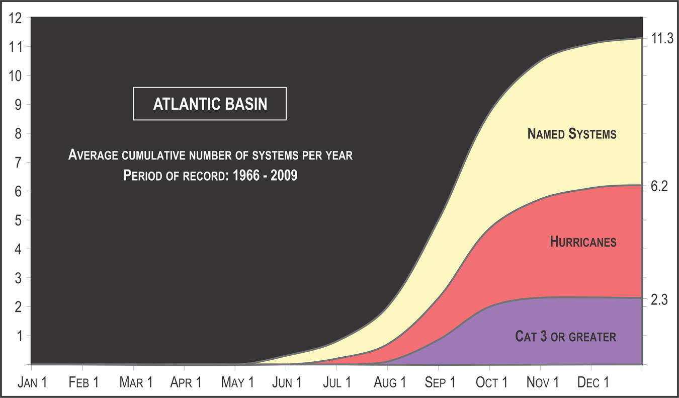
This graphic cycloneye posted in another thread tells the whole story right now.

Image
Last edited by TheStormExpert on Sun Aug 17, 2014 3:55 pm, edited 1 time in total.
0 likes   

User avatar
cycloneye
Admin
Admin
Posts: 145275
Age: 68
Joined: Thu Oct 10, 2002 10:54 am
Location: San Juan, Puerto Rico

Re: Tropical Wave midway between CV Islands and Lesser Antilles

#142 Postby cycloneye » Sun Aug 17, 2014 3:54 pm

Pardon this but I am going off topic here as I have to post the UKMET upgrade made a couple of weeks ago.

http://www.metoffice.gov.uk/media/pdf/s ... i_v2.0.pdf
0 likes   
Visit the Caribbean-Central America Weather Thread where you can find at first post web cams,radars
and observations from Caribbean basin members Click Here

User avatar
blp
Category 5
Category 5
Posts: 2840
Age: 46
Joined: Thu Sep 09, 2004 7:51 pm
Location: Miami, FL
Contact:

Re: Tropical Wave midway between CV Islands and Lesser Antilles

#143 Postby blp » Sun Aug 17, 2014 3:57 pm

FWIW, the FIM models are starting to show similar development in the timeframe. Certainly has not been the most reliable model.

Image
0 likes   
The following post is NOT an official forecast and should not be used as such. It is just the opinion of the poster and may or may not be backed by sound meteorological data. It is NOT endorsed by any professional institution including storm2k.org For Official Information please refer to the NHC and NWS products.

User avatar
blp
Category 5
Category 5
Posts: 2840
Age: 46
Joined: Thu Sep 09, 2004 7:51 pm
Location: Miami, FL
Contact:

Re: Re:

#144 Postby blp » Sun Aug 17, 2014 4:17 pm

TheStormExpert wrote:
blp wrote:
Care to share an explanation for grouping it with the CMC. The Ukmet has never come even close to being like the CMC. It has always been the among most conservative unlike the CMC. Also, look up the stats, it is one of the more reliable models.

It was just recently upgraded and it and the CMC alone are the only models right now that develop this.


Well that clarifies things.... really??? Just what I thought your statement is pure opinion. You should try to do more research.
0 likes   
The following post is NOT an official forecast and should not be used as such. It is just the opinion of the poster and may or may not be backed by sound meteorological data. It is NOT endorsed by any professional institution including storm2k.org For Official Information please refer to the NHC and NWS products.

bamajammer4eva
Category 4
Category 4
Posts: 907
Joined: Sun Apr 18, 2010 3:21 am
Location: Ozark, AL

Re: Tropical Wave midway between CV Islands and Lesser Antilles

#145 Postby bamajammer4eva » Sun Aug 17, 2014 4:27 pm

Looks like the big models see the Atlantic becoming more favorable over the next 10 days for this wave and overall.

Image
0 likes   

canes04
Category 1
Category 1
Posts: 302
Joined: Sat May 22, 2004 5:41 pm
Location: Miami, FL

Re: Tropical Wave midway between CV Islands and Lesser Antilles

#146 Postby canes04 » Sun Aug 17, 2014 4:37 pm

The area just to the east of the broad low needs to be monitored.
The convection has been impressive today and could take over.

IMOP
0 likes   

User avatar
abajan
S2K Supporter
S2K Supporter
Posts: 4230
Joined: Sun Sep 07, 2003 5:10 am
Location: Barbados

Re: Tropical Wave midway between CV Islands and Lesser Antilles

#147 Postby abajan » Sun Aug 17, 2014 6:03 pm

canes04 wrote:The area just to the east of the broad low needs to be monitored.
The convection has been impressive today and could take over.

IMOP
Yes, I've been watching this as well. The convection is continuing to get more impressive by the hour and this is happening during D-MIN.
0 likes   

User avatar
Hurricane Andrew
S2K Supporter
S2K Supporter
Posts: 1891
Age: 26
Joined: Sun May 23, 2010 2:53 pm
Location: KS

Re:

#148 Postby Hurricane Andrew » Sun Aug 17, 2014 6:04 pm

Alyono wrote:This UK run has a much chance at verifying as a Christian does of becoming the president of Indonesia

I don't know whether to find this funny, or odd.
0 likes   

The Enthusiast
NREMT-AEMT, WX nerd

Irene '11, Sandy '12, Irma '17 (SAR)

"Hard to think we were born to live this way..." -Wage War

TheStormExpert

Re: Tropical Wave midway between CV Islands and Lesser Antilles

#149 Postby TheStormExpert » Sun Aug 17, 2014 6:09 pm

abajan wrote:
canes04 wrote:The area just to the east of the broad low needs to be monitored.
The convection has been impressive today and could take over.

IMOP
Yes, I've been watching this as well. The convection is continuing to get more impressive by the hour and this is happening during D-MIN.

I've been wondering if that is what the models are developing, because where the NHC has the X placed there is limited convection.
0 likes   

Alyono
Professional-Met
Professional-Met
Posts: 6961
Joined: Fri Apr 26, 2013 3:52 pm
Location: Texas Coast

Re: Re:

#150 Postby Alyono » Sun Aug 17, 2014 6:16 pm

Hurricane Andrew wrote:
Alyono wrote:This UK run has a much chance at verifying as a Christian does of becoming the president of Indonesia

I don't know whether to find this funny, or odd.


you'd understand if you knew Indonesia. That joke does require knowledge of geography and geopolitical politics (or to be a part of an Indonesian family as I am)
0 likes   

User avatar
cycloneye
Admin
Admin
Posts: 145275
Age: 68
Joined: Thu Oct 10, 2002 10:54 am
Location: San Juan, Puerto Rico

Re: Tropical Wave midway between CV Islands and Lesser Antilles

#151 Postby cycloneye » Sun Aug 17, 2014 6:32 pm

TROPICAL WEATHER OUTLOOK
NWS NATIONAL HURRICANE CENTER MIAMI FL
800 PM EDT SUN AUG 17 2014

For the North Atlantic...Caribbean Sea and the Gulf of Mexico:

Shower activity associated with an elongated area of low pressure
located about midway between the Lesser Antilles and the Cape Verde
Islands is currently minimal. No significant development is
expected during the next two days, but conditions could become a
little more favorable by later in the week as the system moves
slowly westward across the central tropical Atlantic.
* Formation chance through 48 hours...low...10 percent.
* Formation chance through 5 days...medium...30 percent.

$$
Forecaster Pasch
0 likes   
Visit the Caribbean-Central America Weather Thread where you can find at first post web cams,radars
and observations from Caribbean basin members Click Here

User avatar
Hammy
Category 5
Category 5
Posts: 5849
Age: 41
Joined: Fri May 25, 2012 5:25 pm
Contact:

Re: Tropical Wave midway between CV Islands and Lesser Antilles

#152 Postby Hammy » Sun Aug 17, 2014 6:35 pm

Riptide wrote:There has never been a season with a dead Atlantic in late August, best to not downplay everything. Thanks. I think at least a TS is a sure bet at some point before September.


While I don't think we'll go the rest of the month without a storm, 1997 had nothing in the Atlantic from July 26-Sep 3.
0 likes   
The above post is not official and should not be used as such. It is the opinion of the poster and may or may not be backed by sound meteorological data. It is not endorsed by any professional institution or storm2k.org. For official information, please refer to the NHC and NWS products.

User avatar
Riptide
Category 2
Category 2
Posts: 753
Age: 33
Joined: Fri Jul 23, 2010 3:33 pm
Location: Cape May, New Jersey
Contact:

Re: Tropical Wave midway between CV Islands and Lesser Antilles

#153 Postby Riptide » Sun Aug 17, 2014 6:39 pm

Hammy wrote:
Riptide wrote:There has never been a season with a dead Atlantic in late August, best to not downplay everything. Thanks. I think at least a TS is a sure bet at some point before September.


While I don't think we'll go the rest of the month without a storm, 1997 had nothing in the Atlantic from July 26-Sep 3.

Not comparable considering we had Bertha August 1-14th. 1997 was an absolutely dead year with a strong el nino, shearville per se.
0 likes   

User avatar
Hurricane Andrew
S2K Supporter
S2K Supporter
Posts: 1891
Age: 26
Joined: Sun May 23, 2010 2:53 pm
Location: KS

Re: Re:

#154 Postby Hurricane Andrew » Sun Aug 17, 2014 6:46 pm

Alyono wrote:
Hurricane Andrew wrote:
Alyono wrote:This UK run has a much chance at verifying as a Christian does of becoming the president of Indonesia

I don't know whether to find this funny, or odd.


you'd understand if you knew Indonesia. That joke does require knowledge of geography and geopolitical politics (or to be a part of an Indonesian family as I am)

No, I do know quite a bit of geopolitics. I get the joke. It's just odd for a weather forum. ;)
0 likes   

The Enthusiast
NREMT-AEMT, WX nerd

Irene '11, Sandy '12, Irma '17 (SAR)

"Hard to think we were born to live this way..." -Wage War

tolakram
Admin
Admin
Posts: 20009
Age: 62
Joined: Sun Aug 27, 2006 8:23 pm
Location: Florence, KY (name is Mark)

Re: Tropical Wave midway between CV Islands and Lesser Antilles

#155 Postby tolakram » Sun Aug 17, 2014 7:04 pm

Back on topic please.

I posted this in the globals thread. Same system I think....

18Z GFS has something forming in 60 hours, and holds onto a weak storm through 190.

Image

Image
0 likes   
M a r k
- - - - -
Join us in chat: Storm2K Chatroom Invite. Android and IOS apps also available.

The posts in this forum are NOT official forecasts and should not be used as such. Posts are NOT endorsed by any professional institution or STORM2K.org. For official information and forecasts, please refer to NHC and NWS products.

User avatar
blp
Category 5
Category 5
Posts: 2840
Age: 46
Joined: Thu Sep 09, 2004 7:51 pm
Location: Miami, FL
Contact:

Re: Tropical Wave midway between CV Islands and Lesser Antilles

#156 Postby blp » Sun Aug 17, 2014 7:06 pm

The 18z Navgem is a little stronger and further West. So we have UKmet, FIM, CMC, Navgem and Euro to a lesser degree in the general area close to the islands with some type of system. The Ukmet is the fastest right now.

Image
0 likes   
The following post is NOT an official forecast and should not be used as such. It is just the opinion of the poster and may or may not be backed by sound meteorological data. It is NOT endorsed by any professional institution including storm2k.org For Official Information please refer to the NHC and NWS products.

User avatar
gatorcane
S2K Supporter
S2K Supporter
Posts: 23691
Age: 47
Joined: Sun Mar 13, 2005 3:54 pm
Location: Boca Raton, FL

#157 Postby gatorcane » Sun Aug 17, 2014 7:10 pm

blp, what site did you pull that NAVGEM run from? Tropical tidbits site is not working for NAVGEM model.
0 likes   

User avatar
blp
Category 5
Category 5
Posts: 2840
Age: 46
Joined: Thu Sep 09, 2004 7:51 pm
Location: Miami, FL
Contact:

Re: Tropical Wave midway between CV Islands and Lesser Antilles

#158 Postby blp » Sun Aug 17, 2014 7:16 pm

gatorcane wrote:blp, what site did you pull that NAVGEM run from? Tropical tidbits site is not working for NAVGEM model.


Here you go.

https://www.fnmoc.navy.mil/wxmap_cgi/cgi-bin/wxmap_DOD_area.cgi?area=nvg_troplant&set=Tropical
0 likes   
The following post is NOT an official forecast and should not be used as such. It is just the opinion of the poster and may or may not be backed by sound meteorological data. It is NOT endorsed by any professional institution including storm2k.org For Official Information please refer to the NHC and NWS products.

User avatar
gatorcane
S2K Supporter
S2K Supporter
Posts: 23691
Age: 47
Joined: Sun Mar 13, 2005 3:54 pm
Location: Boca Raton, FL

Re: Tropical Wave midway between CV Islands and Lesser Antilles

#159 Postby gatorcane » Sun Aug 17, 2014 7:18 pm

blp wrote:
gatorcane wrote:blp, what site did you pull that NAVGEM run from? Tropical tidbits site is not working for NAVGEM model.


Here you go.

https://www.fnmoc.navy.mil/wxmap_cgi/cgi-bin/wxmap_DOD_area.cgi?area=nvg_troplant&set=Tropical


Great thanks, bookmarked it. You are right, every global model is developing this wave now at some point except the GFS.
0 likes   

User avatar
blp
Category 5
Category 5
Posts: 2840
Age: 46
Joined: Thu Sep 09, 2004 7:51 pm
Location: Miami, FL
Contact:

Re: Tropical Wave midway between CV Islands and Lesser Antilles

#160 Postby blp » Sun Aug 17, 2014 7:19 pm

tolakram wrote:Back on topic please.

I posted this in the globals thread. Same system I think....

18Z GFS has something forming in 60 hours, and holds onto a weak storm through 190.

[]http://imageshack.com/a/img674/2113/XDbVOt.png[/img]

]http://imageshack.com/a/img902/8913/kvoP1j.png[/img]


Very good observation. The GFS has actually come around to a different solution than the 12z and if you compare to the other models it is not that far off. It could be considered the Northern outlier to the others.
0 likes   
The following post is NOT an official forecast and should not be used as such. It is just the opinion of the poster and may or may not be backed by sound meteorological data. It is NOT endorsed by any professional institution including storm2k.org For Official Information please refer to the NHC and NWS products.


Return to “Talkin' Tropics”

Who is online

Users browsing this forum: jaguars_22, Javlin, KeysRedWine and 27 guests