Post away.
AL, 96, 2014081818, , BEST, 0, 119N, 438W, 20, 1009, DB, 0, , 0, 0, 0, 0,
AL, 96, 2014081900, , BEST, 0, 113N, 453W, 20, 1009, DB, 0, , 0, 0, 0, 0,
AL, 96, 2014081906, , BEST, 0, 108N, 467W, 20, 1009, DB, 0, , 0, 0, 0, 0,
AL, 96, 2014081912, , BEST, 0, 104N, 479W, 20, 1009, DB, 0, , 0, 0, 0, 0, 1012, 100, 30, 0, 0,
AL, 96, 2014081918, , BEST, 0, 100N, 490W, 20, 1009, DB
Thread that was the topic for this area at Talking Tropics forum.
viewtopic.php?f=31&t=116570&hilit=&start=0
ATL: CRISTOBAL - Post-Tropical - Discussion
Moderator: S2k Moderators
-
cycloneye

- Admin

- Posts: 149426
- Age: 69
- Joined: Thu Oct 10, 2002 10:54 am
- Location: San Juan, Puerto Rico
ATL: CRISTOBAL - Post-Tropical - Discussion
0 likes
Visit the Caribbean-Central America Weather Thread where you can find at first post web cams,radars
and observations from Caribbean basin members Click Here
and observations from Caribbean basin members Click Here
-
northjaxpro

- S2K Supporter

- Posts: 8900
- Joined: Mon Sep 27, 2010 11:21 am
- Location: Jacksonville, FL
Rather strong at initialization. 1009 mb is decent.
0 likes
NEVER, EVER SAY NEVER in the tropics and weather in general, and most importantly, with life itself!!
________________________________________________________________________________________
Fay 2008 Beryl 2012 Debby 2012 Colin 2016 Hermine 2016 Julia 2016 Matthew 2016 Irma 2017 Dorian 2019
________________________________________________________________________________________
Fay 2008 Beryl 2012 Debby 2012 Colin 2016 Hermine 2016 Julia 2016 Matthew 2016 Irma 2017 Dorian 2019
-
Cunxi Huang

- Category 1

- Posts: 329
- Age: 27
- Joined: Thu Sep 26, 2013 12:17 pm
- Location: San Jose, CA
- Contact:
Great- - 
1. Disorganized shower and thunderstorm activity continues in
association with an elongated area of low pressure that extends from
the northeastern coast of South America into the central tropical
Atlantic. Environmental conditions are forecast to be more conducive
for gradual development of this system during the next few days as
it approaches the Lesser Antilles and moves into the Caribbean Sea.
* Formation chance through 48 hours...medium...30 percent.
* Formation chance through 5 days...medium...40 percent.
0 likes
06 SuTY SAOMAI | 09 TY LINFA | 10 TY FANAPI | 10 SuTY MEGI | 16 SuTY MERANTI | 19 SuTY LEKIMA | 24 C2 FRANCINE
DO NOT use my posts for life and death decisions. For official information, please refer to products from your RSMC and national weather agency.
DO NOT use my posts for life and death decisions. For official information, please refer to products from your RSMC and national weather agency.
-
floridasun78
- Category 5

- Posts: 3755
- Joined: Sun May 17, 2009 10:16 pm
- Location: miami fl
-
tropicwatch

- Category 5
- Posts: 3426
- Age: 62
- Joined: Sat Jun 02, 2007 10:01 am
- Location: The Villages, Florida
- Contact:
ATL: INVEST 96L - Models
Waiting on floaters, they have 96L listed but no images yet.
0 likes
Tropicwatch
Agnes 72', Eloise 75, Elena 85', Kate 85', Charley 86', Florence 88', Beryl 94', Dean 95', Erin 95', Opal 95', Earl 98', Georges 98', Ivan 2004', Arlene 2005', Dennis 2005', Ida 2009' Debby 2012' Irma 2017' Michael 2018'
Agnes 72', Eloise 75, Elena 85', Kate 85', Charley 86', Florence 88', Beryl 94', Dean 95', Erin 95', Opal 95', Earl 98', Georges 98', Ivan 2004', Arlene 2005', Dennis 2005', Ida 2009' Debby 2012' Irma 2017' Michael 2018'

-
micktooth

- S2K Supporter
- Posts: 391
- Joined: Mon Jul 11, 2005 3:47 pm
- Location: PreK:New Orleans,PostK:Colorado
Re: ATL: INVEST 96L - Discussion
If this system does develop and get in to the Gulf, I'm sure the media will be all over it, especially in NOLA. Next Friday 8/29 is the 9th Anniversary of Katrina and the 2nd Anniversary of Hurricane Isaac.
Personal Forecast Disclaimer:
The posts in this forum are NOT official forecast and should not be used as such. They are just the opinion of the poster and may or may not be backed by sound meteorological data. They are NOT endorsed by any professional institution or storm2k.org. For official information, please refer to the NHC and NWS products.
0 likes
-
Kingarabian

- S2K Supporter
- Posts: 16359
- Joined: Sat Aug 08, 2009 3:06 am
- Location: Honolulu, Hawaii
-
Yellow Evan

- Professional-Met

- Posts: 16238
- Age: 27
- Joined: Fri Jul 15, 2011 12:48 pm
- Location: Henderson, Nevada/Honolulu, HI
- Contact:
Re:
Kingarabian wrote:We'll see what the 12z GFS says. 12z Euro was confusing; shows no development.
12z GFS is out already. And Euro isn't as good in the Carb as it is in the EPAC.
0 likes

GFS (which has been pretty good since June with not developing phantom storms) shows a decent system going into the Gulf in about a week. Just goes to show how quickly things can change.
0 likes
The above post is not official and should not be used as such. It is the opinion of the poster and may or may not be backed by sound meteorological data. It is not endorsed by any professional institution or storm2k.org. For official information, please refer to the NHC and NWS products.
-
PTrackerLA

- Category 5
- Posts: 5281
- Age: 42
- Joined: Thu Oct 10, 2002 8:40 pm
- Location: Lafayette, LA
Re: ATL: INVEST 96L - Discussion
micktooth wrote:If this system does develop and get in to the Gulf, I'm sure the media will be all over it, especially in NOLA. Next Friday 8/29 is the 9th Anniversary of Katrina and the 2nd Anniversary of Hurricane Isaac.
Any storm nearing the gulf around labor day is a huge red flag for the northern Gulf Coast. Just since 2005, Katrina, Gustav and Isaac all hit within a few days of each other.
0 likes
-
gatorcane

- S2K Supporter
- Posts: 23708
- Age: 48
- Joined: Sun Mar 13, 2005 3:54 pm
- Location: Boca Raton, FL
Re:
Hammy wrote:GFS (which has been pretty good since June with not developing phantom storms) shows a decent system going into the Gulf in about a week. Just goes to show how quickly things can change.
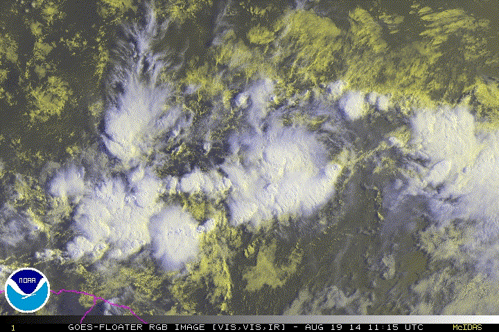
Indeed, within 24 hours we go from seeing "season cancel-related" posts to posts indicating maybe we have a U.S. and Caribbean islands threat on our hands.
I am seeing some turning looking at the vis floater, gradually organizing it looks like:

0 likes
-
wxman57

- Moderator-Pro Met

- Posts: 23174
- Age: 68
- Joined: Sat Jun 21, 2003 8:06 pm
- Location: Houston, TX (southwest)
Re: ATL: INVEST 96L - Discussion
Definitely a potential storm in the making, but I would say best development chances come in the 5-7 day time frame when it reaches the NW Caribbean area. Conditions east of the Caribbean and in the Caribbean are only marginally favorable for any development.
0 likes
-
stormlover2013
Re: ATL: INVEST 96L - Discussion
WXman what is the pattern looking like then, will there be high pressure se coast?? will there be a weakness?
0 likes
-
tolakram
- Admin
- Posts: 20185
- Age: 62
- Joined: Sun Aug 27, 2006 8:23 pm
- Location: Florence, KY (name is Mark)
Re: ATL: INVEST 96L - Discussion
I don't see any turning but I do see the moisture fetch coming in from the south which I believe the GFS 700MB RH maps have been showing.
RGB saved loop
RGB saved loop
0 likes
M a r k
- - - - -
Join us in chat: Storm2K Chatroom Invite. Android and IOS apps also available.
The posts in this forum are NOT official forecasts and should not be used as such. Posts are NOT endorsed by any professional institution or STORM2K.org. For official information and forecasts, please refer to NHC and NWS products.
-
hurricanekid416
- Tropical Storm

- Posts: 179
- Joined: Wed Oct 24, 2012 2:43 pm
Isn't there a Kelvin wave in the area I heard some talk on the forms yesterday about a Kelvin wave coming in to the Atlantic
0 likes
Personal Forecast Disclaimer:
The posts in this forum are NOT official forecast and should not be used as such. They are just the opinion of the poster and may or may not be backed by sound meteorological data. They are NOT endorsed by any professional institution or storm2k.org. For official information, please refer to the NHC and NWS products.
The posts in this forum are NOT official forecast and should not be used as such. They are just the opinion of the poster and may or may not be backed by sound meteorological data. They are NOT endorsed by any professional institution or storm2k.org. For official information, please refer to the NHC and NWS products.


Re: ATL: INVEST 96L - Discussion
wxman57 wrote:Definitely a potential storm in the making, but I would say best development chances come in the 5-7 day time frame when it reaches the NW Caribbean area. Conditions east of the Caribbean and in the Caribbean are only marginally favorable for any development.
Care to share any prelimenary thoughts on where 96L may be headed.
0 likes
-
PTrackerLA
- Category 5
- Posts: 5281
- Age: 42
- Joined: Thu Oct 10, 2002 8:40 pm
- Location: Lafayette, LA
Re: ATL: INVEST 96L - Discussion
perk wrote:wxman57 wrote:Definitely a potential storm in the making, but I would say best development chances come in the 5-7 day time frame when it reaches the NW Caribbean area. Conditions east of the Caribbean and in the Caribbean are only marginally favorable for any development.
Care to share any prelimenary thoughts on where 96L may be headed.
Based off guidance it looks like if the system nears the NW caribbean the GOM would be open and favorable but I would love to hear your take on this as well.
0 likes
-
wxman57
- Moderator-Pro Met
- Posts: 23174
- Age: 68
- Joined: Sat Jun 21, 2003 8:06 pm
- Location: Houston, TX (southwest)
Re: ATL: INVEST 96L - Discussion
perk wrote:wxman57 wrote:Definitely a potential storm in the making, but I would say best development chances come in the 5-7 day time frame when it reaches the NW Caribbean area. Conditions east of the Caribbean and in the Caribbean are only marginally favorable for any development.
Care to share any preliminary thoughts on where 96L may be headed.
Toward the region between the western Bahamas and the NW Caribbean in 7 days is where I'd put it. "Landfall" somewhere between Texas and Bermuda, though it does look like it could move into the south-central to SE Gulf in a week, particularly if it does not develop in the next 3-5 days.
0 likes
-
Cunxi Huang
- Category 1
- Posts: 329
- Age: 27
- Joined: Thu Sep 26, 2013 12:17 pm
- Location: San Jose, CA
- Contact:
Who is online
Users browsing this forum: No registered users and 6 guests