Joe Bastardi @BigJoeBastardi · 5m
Elongates system, ne side likely to take over, not sw side. Until low level center consolidates, models not trustworthy.
ATL: CRISTOBAL - Post-Tropical - Discussion
Moderator: S2k Moderators
-
cycloneye

- Admin

- Posts: 149429
- Age: 69
- Joined: Thu Oct 10, 2002 10:54 am
- Location: San Juan, Puerto Rico
Re: ATL: INVEST 96L - Discussion
0 likes
Visit the Caribbean-Central America Weather Thread where you can find at first post web cams,radars
and observations from Caribbean basin members Click Here
and observations from Caribbean basin members Click Here
-
deltadog03

- Professional-Met

- Posts: 3580
- Joined: Tue Jul 05, 2005 6:16 pm
- Location: Macon, GA

Re: ATL: INVEST 96L - Discussion
...just a little hurricane humor (feel free to insert Key West and correct date date accordingly, LOL )
SPF 20, 50, & 100 to keep the entire family from getting sunburnt during water activities - $30
3 sets of new snorkels, fins and masks for the kids - $90
Overpriced holiday rate for a gulf front hotel room - $250
Earplugs, to drown out complaints from your wife, kids, and mother-in-law for spending Labor Day weekend at a hurricane shelter in Galveston Texas - Priceless
0 likes
Andy D
(For official information, please refer to the NHC and NWS products.)
(For official information, please refer to the NHC and NWS products.)
-
tropicwatch

- Category 5

- Posts: 3426
- Age: 62
- Joined: Sat Jun 02, 2007 10:01 am
- Location: The Villages, Florida
- Contact:
0 likes
Tropicwatch
Agnes 72', Eloise 75, Elena 85', Kate 85', Charley 86', Florence 88', Beryl 94', Dean 95', Erin 95', Opal 95', Earl 98', Georges 98', Ivan 2004', Arlene 2005', Dennis 2005', Ida 2009' Debby 2012' Irma 2017' Michael 2018'
Agnes 72', Eloise 75, Elena 85', Kate 85', Charley 86', Florence 88', Beryl 94', Dean 95', Erin 95', Opal 95', Earl 98', Georges 98', Ivan 2004', Arlene 2005', Dennis 2005', Ida 2009' Debby 2012' Irma 2017' Michael 2018'
-
Hurricane_Luis

- Category 2

- Posts: 723
- Age: 27
- Joined: Sat Jun 23, 2012 3:14 pm
- Location: Tiptree, Essex, United Kingdom
- Contact:
RE: ATL: INVEST 96L - Discussion
I think if there is a circulation it could be around 12N, 51W.
0 likes
-
TheStormExpert
Up to 50/60% now.
TROPICAL WEATHER OUTLOOK
NWS NATIONAL HURRICANE CENTER MIAMI FL
200 PM EDT WED AUG 20 2014
For the North Atlantic...Caribbean Sea and the Gulf of Mexico:
Shower and thunderstorm activity associated with an elongated area
of low pressure located several hundred miles east of the Windward
Islands has become a little better organized during the past few
hours. Additional slow development of this system is possible during
the next day or two, and a tropical depression could form as the
system moves west-northwestward at 10 to 15 mph across the Lesser
Antilles and into the Caribbean Sea. After that time, land
interaction could limit development potential over the weekend.
Regardless of tropical cyclone formation, gusty winds and heavy
rainfall are possible across portions of the Lesser Antilles, Puerto
Rico, and the Virgin Islands on Thursday night and Friday. Interests
in those islands should closely monitor the progress of this system.
An Air Force Reserve Hurricane Hunter aircraft is scheduled to
investigate this system tomorrow afternoon, if necessary.
* Formation chance through 48 hours...medium...50 percent.
* Formation chance through 5 days...high...60 percent.
$$
Forecaster Brennan
0 likes

Re: ATL: INVEST 96L - Discussion
Still somewhat elongated but seems to have a very strong circulation with it. It'll be interesting tomorrow to see what the plane finds by then.
0 likes
The above post is not official and should not be used as such. It is the opinion of the poster and may or may not be backed by sound meteorological data. It is not endorsed by any professional institution or storm2k.org. For official information, please refer to the NHC and NWS products.


-
tropicwatch
- Category 5
- Posts: 3426
- Age: 62
- Joined: Sat Jun 02, 2007 10:01 am
- Location: The Villages, Florida
- Contact:
Looks like the NHC has consolidated the two areas into one. What a merger and the stock market goes wild. 
0 likes
Tropicwatch
Agnes 72', Eloise 75, Elena 85', Kate 85', Charley 86', Florence 88', Beryl 94', Dean 95', Erin 95', Opal 95', Earl 98', Georges 98', Ivan 2004', Arlene 2005', Dennis 2005', Ida 2009' Debby 2012' Irma 2017' Michael 2018'
Agnes 72', Eloise 75, Elena 85', Kate 85', Charley 86', Florence 88', Beryl 94', Dean 95', Erin 95', Opal 95', Earl 98', Georges 98', Ivan 2004', Arlene 2005', Dennis 2005', Ida 2009' Debby 2012' Irma 2017' Michael 2018'


-
TheStormExpert
Re:
panamatropicwatch wrote:Looks like the NHC has consolidated the two areas into one. What a merger and the stock market goes wild.
It also doesn't look like they are sold on the east shift just yet that many models like the CMC, and GFS Ensembles are showing just looking at their 5-day graphic.
0 likes
-
cycloneye
- Admin
- Posts: 149429
- Age: 69
- Joined: Thu Oct 10, 2002 10:54 am
- Location: San Juan, Puerto Rico
Re:
gatorcane wrote:Hey cycloneye - this may put a nice dent in the drought for you guys looking at the moisture field and where it is headed. Let's hope it stays weak when it passes and provides plenty of rain, but not too much
Hopefully that is the case as rationing of water would begin in early September. But as I see things,it looks like a big drought ending coming.
0 likes
Visit the Caribbean-Central America Weather Thread where you can find at first post web cams,radars
and observations from Caribbean basin members Click Here
and observations from Caribbean basin members Click Here
-
TheProfessor

- Professional-Met
- Posts: 3506
- Age: 29
- Joined: Tue Dec 03, 2013 10:56 am
- Location: Wichita, Kansas
Re:
TheStormExpert wrote:2-Day Graphic
2-Day Close up Graphic
5-Day Graphic
If the system takes the southern end of the track, it could be a dangerous situation for the Gulf Coastal States.
0 likes
An alumnus of The Ohio State University.
Your local National Weather Service office is your best source for weather information.
Your local National Weather Service office is your best source for weather information.
-
Gustywind

- Category 5
- Posts: 12334
- Joined: Mon Sep 03, 2007 7:29 am
- Location: Baie-Mahault, GUADELOUPE
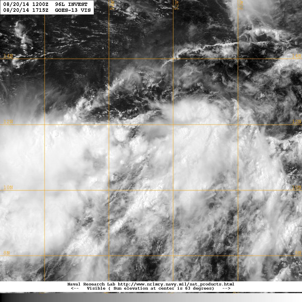
TROPICAL WEATHER DISCUSSION
NWS NATIONAL HURRICANE CENTER MIAMI FL
205 PM EDT WED AUG 20 2014
...SPECIAL FEATURES...
A 1009 MB ATLANTIC OCEAN LOW PRESSURE CENTER IS NEAR 11N53W...IN
THE MONSOON TROUGH. CONVECTIVE PRECIPITATION...NUMEROUS STRONG
FROM 10N TO 13N BETWEEN 50W AND 52W...AND FROM 10N TO 12N
BETWEEN 53W AND 57W. SCATTERED STRONG ALSO IS FROM 8N TO 10N
BETWEEN 55W AND 60W. WIDELY SCATTERED MODERATE TO ISOLATED
STRONG FROM 8N TO 10N BETWEEN 50W AND 55W. GRADUAL DEVELOPMENT
OF THIS FEATURE IS POSSIBLE DURING THE NEXT FEW DAYS...WHILE IT
WILL BE MOVING WESTWARD-NORTHWESTWARD 10 TO 15 KNOTS...ACROSS
THE LESSER ANTILLES INTO THE CARIBBEAN SEA. PEOPLE WHO LIVE IN
THE LESSER ANTILLES AND THE ISLANDS OF THE NORTHEASTERN
CARIBBEAN SEA SHOULD MONITOR CLOSELY THE PROGRESS OF THIS
FEATURE. THE CHANCE FOR DEVELOPMENT INTO A TROPICAL CYCLONE
DURING THE NEXT 48 HOURS IS MEDIUM.
0 likes
Re:
gatorcane wrote:LLC may still be forming around 12.5N, 52W, gaining a little latitude it looks like...
Can almost make a case for 13N and 52W, though I don't think its gaining latitude at all, but rather this point becoming the more dominant low level center. Depending how soon the life get sucked out of the vorticity from "the original 96L", then we might see a quicker rate of development
0 likes
Andy D
(For official information, please refer to the NHC and NWS products.)
(For official information, please refer to the NHC and NWS products.)
-
TheStormExpert
Re: Re:
TheProfessor wrote:TheStormExpert wrote:2-Day Graphic
http://i57.tinypic.com/54vash.png
2-Day Close up Graphic
http://i60.tinypic.com/2ujkydi.jpg
5-Day Graphic
http://i59.tinypic.com/34hdzis.png
If the system takes the southern end of the track, it could be a dangerous situation for the Gulf Coastal States.
Fortunately that is seeming less likely as of right now.
0 likes
-
SFLcane

- S2K Supporter

- Posts: 10281
- Age: 48
- Joined: Sat Jun 05, 2010 1:44 pm
- Location: Lake Worth Florida
Re: ATL: INVEST 96L - Discussion
000
NOUS42 KNHC 201546
REPRPD
WEATHER RECONNAISSANCE FLIGHTS
CARCAH, NATIONAL HURRICANE CENTER, MIAMI, FL.
1145 AM EDT WED 20 AUGUST 2014
SUBJECT: TROPICAL CYCLONE PLAN OF THE DAY (TCPOD)
VALID 21/1100Z TO 22/1100Z AUGUST 2014
TCPOD NUMBER.....14-081
I. ATLANTIC REQUIREMENTS
1. SUSPECT AREA (APPROACHING LESSER ANTILLES)
FLIGHT ONE -- TEAL 75
A. 21/1730Z
B. AFXXX 01EEA INVEST
C. 21/1515Z
D. 15.0N 57.5W
E. 21/1715Z TO 21/2200Z
F. SFC TO 10,000 FT
FLIGHT TWO -- TEAL 76
A. 22/0530Z, 1130Z
B. AFXXX 0204A CYCLONE
C. 22/0415Z
D. 16.5N 61.5W
E. 22/0515Z TO 22/1130Z
F. SFC TO 10,000 FT
2. OUTLOOK FOR SUCCEEDING DAY.....CONTINUE 6-HRLY FIXES
IF SYSTEM DEVELOPS.
II. PACIFIC REQUIREMENTS
1. NEGATIVE RECONNAISSANCE REQUIREMENTS.
2. SUCCEEDING DAY OUTLOOK.....NEGATIVE.
$$
WJM
0 likes
-
Gustywind
- Category 5
- Posts: 12334
- Joined: Mon Sep 03, 2007 7:29 am
- Location: Baie-Mahault, GUADELOUPE
Re: Re:
cycloneye wrote:gatorcane wrote:Hey cycloneye - this may put a nice dent in the drought for you guys looking at the moisture field and where it is headed. Let's hope it stays weak when it passes and provides plenty of rain, but not too much
Hopefully that is the case as rationing of water would begin in early September. But as I see things,it looks like a big drought ending coming.
0 likes

Elongation is fairly common with systems trying to extricate themselves from the monsoon trough. Could take a little longer to cut off than than the current models are showing. That would mean at least one more shift left in the models. I'm beginning to question the major storm north of Cuba scenario.
0 likes
Who is online
Users browsing this forum: No registered users and 7 guests