ATL: CRISTOBAL - Post-Tropical - Discussion

Moderator: S2k Moderators

Message
Author
User avatar
Evil Jeremy
S2K Supporter
S2K Supporter
Posts: 5463
Age: 31
Joined: Mon Apr 10, 2006 2:10 pm
Location: Los Angeles, CA

Re: ATL: INVEST 96L - Discussion

#221 Postby Evil Jeremy » Wed Aug 20, 2014 6:35 pm

Strengthening and organizing:

18z:
Image

21z (aprox):
Image
0 likes   
Frances 04 / Jeanne 04 / Katrina 05 / Wilma 05 / Fay 08 / Debby 12 / Andrea 13 / Colin 16 / Hermine 16 / Matthew 16 / Irma 17

User avatar
sunnyday
Category 5
Category 5
Posts: 1590
Joined: Thu Sep 04, 2003 8:16 pm

Re: ATL: INVEST 96L - Discussion

#222 Postby sunnyday » Wed Aug 20, 2014 6:38 pm

I heard on the Weather Channel that it has been over 3200 days since Fl was hit by a hurricane. They seem to have good luck down there most of the time.
0 likes   

User avatar
cycloneye
Admin
Admin
Posts: 143881
Age: 68
Joined: Thu Oct 10, 2002 10:54 am
Location: San Juan, Puerto Rico

Re: ATL: INVEST 96L - Discussion

#223 Postby cycloneye » Wed Aug 20, 2014 6:41 pm

50%-70%

TROPICAL WEATHER OUTLOOK
NWS NATIONAL HURRICANE CENTER MIAMI FL
800 PM EDT WED AUG 20 2014

For the North Atlantic...Caribbean Sea and the Gulf of Mexico:

Shower and thunderstorm activity associated with an elongated area
of low pressure located several hundred miles east of the Windward
Islands is slowly becoming better organized. Additional development
is possible during the next day or two, and a tropical depression
could form as the system moves west-northwestward at 10 to 15 mph
across the Lesser Antilles and into the Caribbean Sea. After that
time, land interaction could limit development potential over the
weekend. Regardless of tropical cyclone formation, gusty winds and
heavy rainfall are possible across portions of the Lesser Antilles,
Puerto Rico, and the Virgin Islands on Thursday night and Friday.
Interests in those islands should closely monitor the progress of
this system. An Air Force Reserve Hurricane Hunter aircraft is
scheduled to investigate the low tomorrow afternoon, if necessary.
* Formation chance through 48 hours...medium...50 percent.
* Formation chance through 5 days...high...70 percent.

$$
Forecaster Beven
0 likes   
Visit the Caribbean-Central America Weather Thread where you can find at first post web cams,radars
and observations from Caribbean basin members Click Here

User avatar
SouthDadeFish
Professional-Met
Professional-Met
Posts: 2835
Joined: Thu Sep 23, 2010 2:54 pm
Location: Miami, FL
Contact:

#224 Postby SouthDadeFish » Wed Aug 20, 2014 6:50 pm

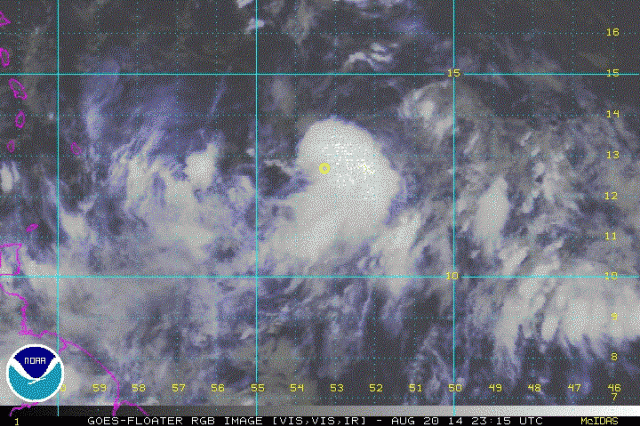
I am very impressed by recent microwave imagery as well the most recent satellite trends. Convection has been persistent during diurnal minimum and deep convection continues to fire and expand near the suspected LLC. I am thinking a LLC may be forming around 12.7 N and 53.4 W.

Edit: Still no observational evidence for a LLC yet, though.
Last edited by SouthDadeFish on Wed Aug 20, 2014 6:52 pm, edited 1 time in total.
0 likes   

User avatar
toad strangler
S2K Supporter
S2K Supporter
Posts: 4543
Joined: Sun Jul 28, 2013 3:09 pm
Location: Earth
Contact:

Re: ATL: INVEST 96L - Discussion

#225 Postby toad strangler » Wed Aug 20, 2014 6:51 pm

sunnyday wrote:I heard on the Weather Channel that it has been over 3200 days since Fl was hit by a hurricane. They seem to have good luck down there most of the time.

Well actually FL is in the midst of it's longest hurricane drought of any intensity back to the US Civil War. Florida is a HUGE state when you look at the map and realize the multiple directions a system can come in and nail a gigantic amount of coastline.

Of course, there is no such thing as "overdue" in weather so the US Civil War note is just that. A note!
0 likes   

ozonepete
Professional-Met
Professional-Met
Posts: 4743
Joined: Mon Sep 07, 2009 3:23 pm
Location: From Ozone Park, NYC / Now in Brooklyn, NY

Re: ATL: INVEST 96L - Discussion

#226 Postby ozonepete » Wed Aug 20, 2014 6:54 pm

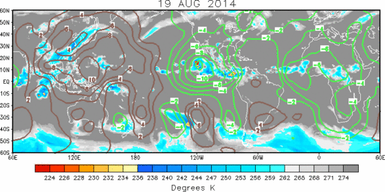
Boy the visual clues from rgb satellite sure look like it's developing rapidly now. Seems to have consolidated a COC both at mid-levels and quite likely down to the surface just in the last few hours. Interesting too that this is the first time since 2012 I've seen the MJO this conducive for development in the western Atlantic (negative 200 hPA velocity potential anomalies) and it's only going to get more conducive. (Green lines are negative anomalies which aid in vertical thunderstorm development, and these anomalies move from west to east so you can see how the core of very negative anomalies are going to move over this system soon.)

Image
0 likes   

User avatar
cycloneye
Admin
Admin
Posts: 143881
Age: 68
Joined: Thu Oct 10, 2002 10:54 am
Location: San Juan, Puerto Rico

Re:

#227 Postby cycloneye » Wed Aug 20, 2014 6:57 pm

SouthDadeFish wrote:I am very impressed by recent microwave imagery as well the most recent satellite trends. Convection has been persistent during diurnal minimum and deep convection continues to fire and expand near the suspected LLC. I am thinking a LLC may be forming around 12.7 N and 53.4 W.

Edit: Still no observational evidence for a LLC yet, though.


They may wait for recon to confirm unless there is an ASCAT pass showing a well defined LLC before that afternoon mission.
0 likes   
Visit the Caribbean-Central America Weather Thread where you can find at first post web cams,radars
and observations from Caribbean basin members Click Here

User avatar
gatorcane
S2K Supporter
S2K Supporter
Posts: 23689
Age: 47
Joined: Sun Mar 13, 2005 3:54 pm
Location: Boca Raton, FL

#228 Postby gatorcane » Wed Aug 20, 2014 7:02 pm

Saved loop, it's organizing for sure, a bit faster than I expected:
Image
0 likes   

ozonepete
Professional-Met
Professional-Met
Posts: 4743
Joined: Mon Sep 07, 2009 3:23 pm
Location: From Ozone Park, NYC / Now in Brooklyn, NY

Re: Re:

#229 Postby ozonepete » Wed Aug 20, 2014 7:03 pm

cycloneye wrote:
SouthDadeFish wrote:I am very impressed by recent microwave imagery as well the most recent satellite trends. Convection has been persistent during diurnal minimum and deep convection continues to fire and expand near the suspected LLC. I am thinking a LLC may be forming around 12.7 N and 53.4 W.

Edit: Still no observational evidence for a LLC yet, though.


They may wait for recon to confirm unless there is an ASCAT pass showing a well defined LLC before that afternoon mission.


I have the same point, SDF. :)
And yes I agree Luis, a new ASCAT pass or a 37 GHZ microwave pass could tell us.

Image
0 likes   

ozonepete
Professional-Met
Professional-Met
Posts: 4743
Joined: Mon Sep 07, 2009 3:23 pm
Location: From Ozone Park, NYC / Now in Brooklyn, NY

Re: ATL: INVEST 96L - Discussion

#230 Postby ozonepete » Wed Aug 20, 2014 7:06 pm

:uarrow: For those who don't know, 37 GHz microwave detects circulation returns from much lower than 85 GHz so they give us a good idea if there's an LLC present when clouds obscure the center during the day or at night when no visible images are available.
0 likes   

TheStormExpert

Re: ATL: INVEST 96L - Discussion

#231 Postby TheStormExpert » Wed Aug 20, 2014 7:15 pm

cycloneye wrote:50%-70%

TROPICAL WEATHER OUTLOOK
NWS NATIONAL HURRICANE CENTER MIAMI FL
800 PM EDT WED AUG 20 2014

For the North Atlantic...Caribbean Sea and the Gulf of Mexico:

Shower and thunderstorm activity associated with an elongated area
of low pressure located several hundred miles east of the Windward
Islands is slowly becoming better organized. Additional development
is possible during the next day or two, and a tropical depression
could form as the system moves west-northwestward at 10 to 15 mph
across the Lesser Antilles and into the Caribbean Sea. After that
time, land interaction could limit development potential over the
weekend. Regardless of tropical cyclone formation, gusty winds and
heavy rainfall are possible across portions of the Lesser Antilles,
Puerto Rico, and the Virgin Islands on Thursday night and Friday.
Interests in those islands should closely monitor the progress of
this system. An Air Force Reserve Hurricane Hunter aircraft is
scheduled to investigate the low tomorrow afternoon, if necessary.
* Formation chance through 48 hours...medium...50 percent.
* Formation chance through 5 days...high...70 percent.

$$
Forecaster Beven

Looks like I was spot on correct earlier when I predicted it would possibly be 50/70% @ 8pm. 8-)
0 likes   

User avatar
gatorcane
S2K Supporter
S2K Supporter
Posts: 23689
Age: 47
Joined: Sun Mar 13, 2005 3:54 pm
Location: Boca Raton, FL

#232 Postby gatorcane » Wed Aug 20, 2014 7:16 pm

NWS Miami brings some sanity to the situation:

LONG TERM...
SATURDAY THROUGH WEDNESDAY...
FRIDAY PATTERN FAVORING INLAND AND WEST COAST IN THE AFTERNOON
AND EVENING WILL EXTEND THROUGH THE WEEKEND AS RIDGE OF HIGH
PRESSURE REMAINS TO OUR NORTH. FOR THE EARLY PART OF NEXT WEEK ALL
EYES ARE IN THE TROPICS. AT THIS TIME THE UNCERTAINTY IS JUST TOO
LARGE. GLOBAL MODELS DIVERGE SIGNIFICANTLY IN TERMS OF DEGREE OF
STORM DEVELOPMENT, WHERE IT WILL GO AND TIMING. SO AT THIS TIME
SOUTH FLORIDA RESIDENTS ARE JUST ADVISED TO STAY TUNED OVER THE
WEEKEND. NOTHING TO WORRY ABOUT AT THIS TIME OTHER THAN CHECKING
OUR PREPAREDNESS PLANS. AFTER ALL, WE ARE HEADING INTO THE PEAK OF
THE HURRICANE SEASON.

http://forecast.weather.gov/product.php ... glossary=1
0 likes   

User avatar
Hurricane Andrew
S2K Supporter
S2K Supporter
Posts: 1891
Age: 26
Joined: Sun May 23, 2010 2:53 pm
Location: KS

Re: ATL: INVEST 96L - Discussion

#233 Postby Hurricane Andrew » Wed Aug 20, 2014 7:23 pm

Evil Jeremy wrote:Strengthening and organizing:

18z:
Image

21z (aprox):
Image

That is a fairly impressive microwave pass. (21z)
PS: Good to see you again, Jeremy. Been a while.
0 likes   

The Enthusiast
NREMT-AEMT, WX nerd

Irene '11, Sandy '12, Irma '17 (SAR)

"Hard to think we were born to live this way..." -Wage War

User avatar
TropicalAnalystwx13
Category 5
Category 5
Posts: 2109
Age: 27
Joined: Tue Jul 19, 2011 8:20 pm
Location: Wilmington, NC
Contact:

#234 Postby TropicalAnalystwx13 » Wed Aug 20, 2014 7:35 pm

Invest 96L has organized quite nicely today, with blossoming convection over what an afternoon microwave pass indicated was a fairly well-defined low-level circulation. Moving forward in time, the environment looks generally favorable for development. First off, a large anticyclone has setup over 96L, lowering wind shear to 5 to 10 knots and negating any potential shear from the upper-level low northwest of Puerto Rico. There is some dry air in the vicinity of 96L as evidenced by some outflow boundaries earlier this evening, but this shouldn't inhibit development altogether. Third, a strong convectively-coupled kelvin wave is currently pushing over Panama into the Atlantic Ocean. It's important to note that disturbances and tropical cyclones often benefit most from CCKWs two days after they pass by (Ventrice, 2012). The biggest issue for Invest 96L during its lifetime will be interaction with the Greater Antilles; if this passes over Hispaniola, it could just dissipate (and potentially reform in the Bahamas). If not, it looks (from my perspective) at this point that this would have a good chance to appreciably intensify in the Bahamas region. It's too early to say how strong this would be at peak and where it would make landfall, if it ever does.
0 likes   

User avatar
cycloneye
Admin
Admin
Posts: 143881
Age: 68
Joined: Thu Oct 10, 2002 10:54 am
Location: San Juan, Puerto Rico

Re: ATL: INVEST 96L - Discussion

#235 Postby cycloneye » Wed Aug 20, 2014 7:53 pm

00z Best Track.

AL, 96, 2014082100, , BEST, 0, 125N, 543W, 25, 1009, DB
0 likes   
Visit the Caribbean-Central America Weather Thread where you can find at first post web cams,radars
and observations from Caribbean basin members Click Here

User avatar
Gustywind
Category 5
Category 5
Posts: 12334
Joined: Mon Sep 03, 2007 7:29 am
Location: Baie-Mahault, GUADELOUPE

#236 Postby Gustywind » Wed Aug 20, 2014 8:13 pm

TROPICAL WEATHER DISCUSSION
NWS NATIONAL HURRICANE CENTER MIAMI FL
805 PM EDT WED AUG 20 2014

...SPECIAL FEATURES...

A 1009 MB ATLANTIC OCEAN LOW PRESSURE CENTER IS NEAR 12N53W...IN
THE MONSOON TROUGH. SCATTERED MODERATE TO ISOLATED STRONG
CONVECTION IS FROM 10N-13N BETWEEN 51W-58W. GRADUAL DEVELOPMENT
OF THIS FEATURE IS POSSIBLE DURING THE NEXT FEW DAYS...WHILE IT
WILL BE MOVING WESTWARD-NORTHWESTWARD 10-15 KNOTS...ACROSS THE
LESSER ANTILLES INTO THE CARIBBEAN SEA. PEOPLE WHO LIVE IN THE
LESSER ANTILLES AND THE ISLANDS OF THE NORTHEASTERN CARIBBEAN
SEA SHOULD MONITOR CLOSELY THE PROGRESS OF THIS FEATURE.
THE
CHANCE FOR DEVELOPMENT INTO A TROPICAL CYCLONE DURING THE NEXT
48 HOURS IS MEDIUM.
0 likes   

User avatar
cycloneye
Admin
Admin
Posts: 143881
Age: 68
Joined: Thu Oct 10, 2002 10:54 am
Location: San Juan, Puerto Rico

Re: ATL: INVEST 96L - Discussion

#237 Postby cycloneye » Wed Aug 20, 2014 8:17 pm

Here is the RAMSDIS loop that shows how it is organizing and the movement.

http://rammb.cira.colostate.edu/ramsdis ... display=12
0 likes   
Visit the Caribbean-Central America Weather Thread where you can find at first post web cams,radars
and observations from Caribbean basin members Click Here

floridasun78
Category 5
Category 5
Posts: 3755
Joined: Sun May 17, 2009 10:16 pm
Location: miami fl

Re:

#238 Postby floridasun78 » Wed Aug 20, 2014 8:23 pm

gatorcane wrote:NWS Miami brings some sanity to the situation:

LONG TERM...
SATURDAY THROUGH WEDNESDAY...
FRIDAY PATTERN FAVORING INLAND AND WEST COAST IN THE AFTERNOON
AND EVENING WILL EXTEND THROUGH THE WEEKEND AS RIDGE OF HIGH
PRESSURE REMAINS TO OUR NORTH. FOR THE EARLY PART OF NEXT WEEK ALL
EYES ARE IN THE TROPICS. AT THIS TIME THE UNCERTAINTY IS JUST TOO
LARGE. GLOBAL MODELS DIVERGE SIGNIFICANTLY IN TERMS OF DEGREE OF
STORM DEVELOPMENT, WHERE IT WILL GO AND TIMING. SO AT THIS TIME
SOUTH FLORIDA RESIDENTS ARE JUST ADVISED TO STAY TUNED OVER THE
WEEKEND. NOTHING TO WORRY ABOUT AT THIS TIME OTHER THAN CHECKING
OUR PREPAREDNESS PLANS. AFTER ALL, WE ARE HEADING INTO THE PEAK OF
THE HURRICANE SEASON.

http://forecast.weather.gov/product.php ... glossary=1

i here miami live mobile home so watching with you all 96l
0 likes   

User avatar
Gustywind
Category 5
Category 5
Posts: 12334
Joined: Mon Sep 03, 2007 7:29 am
Location: Baie-Mahault, GUADELOUPE

Re: ATL: INVEST 96L - Discussion

#239 Postby Gustywind » Wed Aug 20, 2014 8:24 pm

cycloneye wrote:Here is the RAMSDIS loop that shows how it is organizing and the movement.

http://rammb.cira.colostate.edu/ramsdis ... display=12

Good catch Luis :) very interresting! Given my untrained eyes, 96L continues to take shape tonight and having a decent sat appearence now...

Personal Forecast Disclaimer:
The posts in this forum are NOT official forecast and should not be used as such. They are just the opinion of the poster and may or may not be backed by sound meteorological data. They are NOT endorsed by any professional institution or storm2k.org. For official information, please refer to the NHC and NWS products.
0 likes   

User avatar
meriland23
Category 5
Category 5
Posts: 1239
Age: 37
Joined: Mon Aug 29, 2011 9:29 pm

#240 Postby meriland23 » Wed Aug 20, 2014 8:30 pm

Seems to be huddling up now..doesn't look so all over the place. Definitely better organized.
0 likes   
The posts in this forum are NOT official forecast and should not be used as such. They are just the opinion of the poster and may or may not be backed by sound meteorological data. They are NOT endorsed by any professional institution or storm2k.org. For official information, please refer to the NHC and NWS products.


Return to “2014”

Who is online

Users browsing this forum: No registered users and 51 guests