ATL: CRISTOBAL - Models
Moderator: S2k Moderators
-
Incident_MET

- Professional-Met

- Posts: 63
- Joined: Tue Mar 28, 2006 10:22 pm
- Location: Floridana Beach, FL
-
somethingfunny

- ChatStaff

- Posts: 3926
- Age: 37
- Joined: Thu May 31, 2007 10:30 pm
- Location: McKinney, Texas

Re:
somethingfunny wrote:Are there any models that still don't develop 96L into a storm?
I don't think so, at this point it seems to differ simply to what degree the storm develops (and of course where it goes.)
0 likes
The above post is not official and should not be used as such. It is the opinion of the poster and may or may not be backed by sound meteorological data. It is not endorsed by any professional institution or storm2k.org. For official information, please refer to the NHC and NWS products.
-
somethingfunny
- ChatStaff
- Posts: 3926
- Age: 37
- Joined: Thu May 31, 2007 10:30 pm
- Location: McKinney, Texas
Re: Re:
Hammy wrote:somethingfunny wrote:Are there any models that still don't develop 96L into a storm?
I don't think so, at this point it seems to differ simply to what degree the storm develops (and of course where it goes.)
I think it's interesting even with pretty much unanimous model support for a tropical storm within 5 days, the NHC isn't willing to wager higher than 70% while Hispaniola is in the picture.
0 likes
I am not a meteorologist, and any posts made by me are not official forecasts or to be interpreted as being intelligent. These posts are just my opinions and are probably silly opinions.

The convection is firing a little further north up near 15N, if the center redevelops up there it should stay north of Hispaniola. Ridges and weaknesses are hard to predict more than three days out but the current trend in the models to recurve the system east of Florida could validate. Later model runs should be more valid than earlier runs.
0 likes


Re: ATL: INVEST 96L - Models
WOW Tuesday the GFS had 96L hitting Houston/Galveston and now recurving east of Florida. 
0 likes

Re: ATL: INVEST 96L - Models
What I don't get while the Euro and GFS have gone with a recurve is that both the UKMET and HWRF, two very good models, are persistent of no recurve, in fact the latest 06z HWRF so far looks identical to its earlier 0z run.
0 likes

Re: ATL: INVEST 96L - Models
The huge changes in the "predictions" are always amazing to me. All the way from Texas earlier this week to possible recurve now! What I don't understand this time is why the models are showing such scenarios when there is not even a storm present yet. I wonder if there will even be one.
If there is another recurve, I will feel crazy to have expected otherwise.
If there is another recurve, I will feel crazy to have expected otherwise.
0 likes
-
tolakram
- Admin

- Posts: 20186
- Age: 62
- Joined: Sun Aug 27, 2006 8:23 pm
- Location: Florence, KY (name is Mark)
Re: ATL: INVEST 96L - Models
NDG wrote:What I don't get while the Euro and GFS have gone with a recurve is that both the UKMET and HWRF, two very good models, are persistent of no recurve, in fact the latest 06z HWRF so far looks identical to its earlier 0z run.
I'm not so sure the HWRF is that much better, maybe it just got lucky a few times? This could be the big test for it.
0 likes
M a r k
- - - - -
Join us in chat: Storm2K Chatroom Invite. Android and IOS apps also available.
The posts in this forum are NOT official forecasts and should not be used as such. Posts are NOT endorsed by any professional institution or STORM2K.org. For official information and forecasts, please refer to NHC and NWS products.
-
Blown Away

- S2K Supporter

- Posts: 10253
- Joined: Wed May 26, 2004 6:17 am
Re: ATL: INVEST 96L - Models

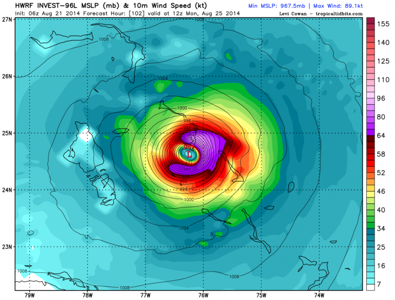
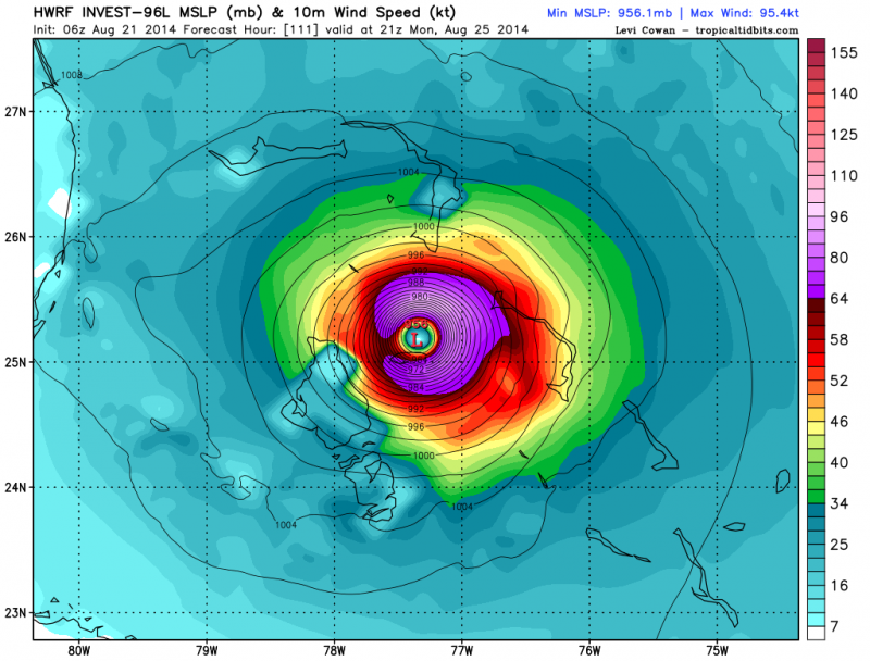
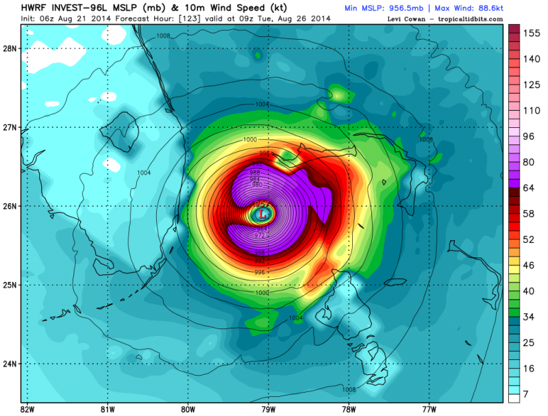
06z...

06z... Steady increasing...

06z...
0 likes
Hurricane Eye Experience: David 79, Irene 99, Frances 04, Jeanne 04, Wilma 05… Hurricane Brush Experience: Andrew 92, Erin 95, Floyd 99, Matthew 16, Irma 17, Ian 22, Nicole 22…
-
CYCLONE MIKE
- Category 5

- Posts: 2183
- Joined: Tue Aug 31, 2004 6:04 pm
- Location: Gonzales, LA
Re: ATL: INVEST 96L - Models
Well seems to me the major models are now in agreement and latching on to this being much weaker with yet another summertime trough catching this and turning it out to sea. Guess all that's left is strength and when it makes the turn. Shouldn't really come as a big surprise to anyone as this has been the theme this year.
0 likes
This post is NOT AN OFFICIAL FORECAST and should not be used as such. It is just the opinion of the poster and may or may not be backed by sound meteorological data. It is NOT endorsed by any professional institution including storm2k.org. For Official Information please refer to the NHC and NWS products.
Re: ATL: INVEST 96L - Models
tolakram wrote:NDG wrote:What I don't get while the Euro and GFS have gone with a recurve is that both the UKMET and HWRF, two very good models, are persistent of no recurve, in fact the latest 06z HWRF so far looks identical to its earlier 0z run.
I'm not so sure the HWRF is that much better, maybe it just got lucky a few times? This could be the big test for it.
It can't be any worse the GFS has shifted from Texas to east of Florida in 2 days. That' over a thousand miles.
0 likes


-
ninel conde
Re: ATL: INVEST 96L - Models
CYCLONE MIKE wrote:Well seems to me the major models are now in agreement and latching on to this being much weaker with yet another summertime trough catching this and turning it out to sea. Guess all that's left is strength and when it makes the turn. Shouldn't really come as a big surprise to anyone as this has been the theme this year.
been the theme for many years. we can clearly see on the 06 GFS that the nw atlantic ridge failed to materialize yet again and what we have as in the last 8 years is low pressure in the nw atlantic which always means recurve. what we also see is the high in the subtropics almost completely gone so we might see a quik recurver off africa.
0 likes
Who is online
Users browsing this forum: No registered users and 31 guests