EPAC: KARINA - Post-Tropical
Moderator: S2k Moderators
-
Yellow Evan

- Professional-Met

- Posts: 16240
- Age: 27
- Joined: Fri Jul 15, 2011 12:48 pm
- Location: Henderson, Nevada/Honolulu, HI
- Contact:
-
Yellow Evan
- Professional-Met
- Posts: 16240
- Age: 27
- Joined: Fri Jul 15, 2011 12:48 pm
- Location: Henderson, Nevada/Honolulu, HI
- Contact:
-
supercane4867
- Category 5

- Posts: 4966
- Joined: Wed Nov 14, 2012 10:43 am
Re: EPAC: KARINA - Tropical Storm
TROPICAL STORM KARINA DISCUSSION NUMBER 37
NWS NATIONAL HURRICANE CENTER MIAMI FL EP112014
800 PM PDT THU AUG 21 2014
Deep convection has continued to develop near the center of Karina,
especially in the southern semicircle, and the low-level center is
embedded in the middle of the more circular cloud shield. Two
earlier ASCAT passes showed 50 kt and 52 kt peak surface winds to
the southeast of the center, so the intensity has been bumped up to
55 kt for this advisory.
The initial motion estimate is 090/02 kt based on microwave
satellite positions over the past several hours. After nearly three
days of saying the same thing in our discussions, there isn't much
more to add. Karina will gradually get pulled eastward and
northeastward by the larger circulation of Tropical Storm Lowell, as
the latter cyclone passes to the northeast of Karina in 2-3 days.
The majority of the NHC track guidance is now indicating a
considerably slower forward speed on Days 4 and 5 as Karina weakens
over cold water and becomes more vertically shallow. The official
advisory track is similar to but a little faster than the consensus
model TVCE out of respect for the faster GFS model.
Recent microwave images continue to show a partial eyewall
structure. The vertical shear is forecast to subside to around 5 kt
during the next 12 hours, so there is a brief window of opportunity
for Karina to strengthen. However, the vertical shear is forecast to
increase again at 24 hours and beyond as the cyclone begins to move
over cooler water. This combination of unfavorable conditions should
induce gradual weakening, with the Karina becoming a non-convective
remnant low pressure by 96 hours when the cyclone is moving over
22-23C sea-surface temperatures and into a much cooler and drier
airmass. The NHC intensity forecast closely follows the intensity
consensus model ICON.
FORECAST POSITIONS AND MAX WINDS
INIT 22/0300Z 14.8N 136.5W 55 KT 65 MPH
12H 22/1200Z 15.1N 135.9W 55 KT 65 MPH
24H 23/0000Z 15.7N 135.1W 50 KT 60 MPH
36H 23/1200Z 16.4N 134.1W 45 KT 50 MPH
48H 24/0000Z 17.3N 132.8W 40 KT 45 MPH
72H 25/0000Z 19.0N 129.8W 35 KT 40 MPH
96H 26/0000Z 21.5N 129.0W 30 KT 35 MPH...POST-TROP/REMNT LOW
120H 27/0000Z 25.5N 130.5W 25 KT 30 MPH...POST-TROP/REMNT LOW
$$
Forecaster Stewart
0 likes
-
Yellow Evan
- Professional-Met
- Posts: 16240
- Age: 27
- Joined: Fri Jul 15, 2011 12:48 pm
- Location: Henderson, Nevada/Honolulu, HI
- Contact:
000
WTPZ41 KNHC 220859
TCDEP1
TROPICAL STORM KARINA DISCUSSION NUMBER 38
NWS NATIONAL HURRICANE CENTER MIAMI FL EP112014
200 AM PDT FRI AUG 22 2014
Karina's convective structure has changed little during the past
few hours. An 0613 UTC ASCAT-B pass just clipped the western
portion of the cyclone's circulation and showed some reliable 50-kt
barbs. Therefore, the initial intensity is held at 55 kt.
A 12-hour motion estimate yields 085/4 kt, although satellite
animation seems to suggest that the cyclone is beginning to be
pulled northeastward. Karina's movement will be at the mercy of
Tropical Storms Lowell and Marie through the entire forecast
period. For the first 3-4 days, Karina is forecast to move
generally northeastward on the southern side of Lowell. The big
difference from previous model cycles is that the guidance no
longer shows Karina being absorbed by Lowell. Instead, Karina
slows down when it begins to feel the circulation of Marie. The
track guidance has slowed down and shifted significantly to the
west by days 4 and 5, and the updated NHC track forecast has been
pulled southward at those times, but it is still on the northern
edge of the guidance envelope.
Karina's updated track keeps it over waters warmer than 26 degrees
Celsius for another 48 hours or so. Vertical shear may increase a
little, but overall little change in intensity is forecast during
the next day or two. Weakening should commence by 48 hours
when Karina moves over cooler water and into a drier air mass.
However, since the forecast track has been pulled southward, Karina
may not weaken quite as fast as previously thought, and the updated
NHC forecast keeps Karina as a tropical cyclone through day 4.
FORECAST POSITIONS AND MAX WINDS
INIT 22/0900Z 14.8N 135.8W 55 KT 65 MPH
12H 22/1800Z 15.3N 135.3W 55 KT 65 MPH
24H 23/0600Z 16.2N 134.6W 55 KT 65 MPH
36H 23/1800Z 17.0N 133.6W 55 KT 65 MPH
48H 24/0600Z 17.6N 132.2W 50 KT 60 MPH
72H 25/0600Z 18.5N 129.5W 40 KT 45 MPH
96H 26/0600Z 20.5N 129.5W 30 KT 35 MPH
120H 27/0600Z 22.5N 131.5W 25 KT 30 MPH...POST-TROP/REMNT LOW
$$
Forecaster Berg
0 likes
-
Yellow Evan
- Professional-Met
- Posts: 16240
- Age: 27
- Joined: Fri Jul 15, 2011 12:48 pm
- Location: Henderson, Nevada/Honolulu, HI
- Contact:
-
cycloneye

- Admin

- Posts: 149503
- Age: 69
- Joined: Thu Oct 10, 2002 10:54 am
- Location: San Juan, Puerto Rico
Re: EPAC: KARINA - Tropical Storm
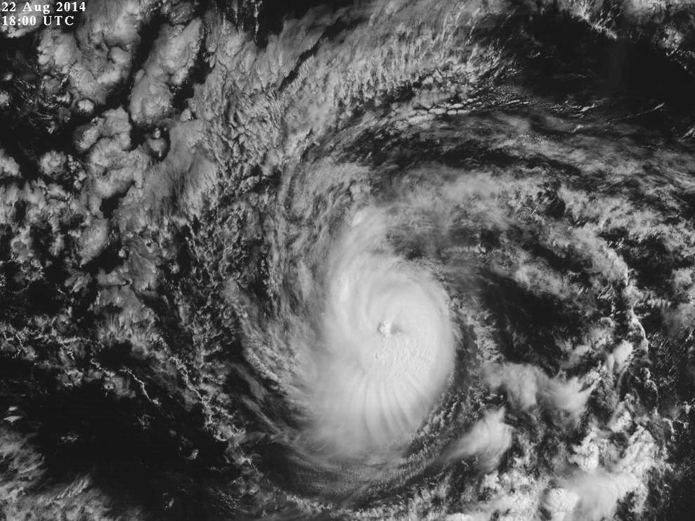
TROPICAL STORM KARINA DISCUSSION NUMBER 39
NWS NATIONAL HURRICANE CENTER MIAMI FL EP112014
800 AM PDT FRI AUG 22 2014
Conventional satellite imagery shows that the cloud pattern of
Karina has been improving during the past 6 hours, and a banding eye
feature is becoming apparent in the most recent images. An ADT
objective intensity estimate and a Dvorak classification from TAFB
support an intensity of 55 kt. However, based on the forming
banding eye feature and an emerging small warm spot visible
in the infrared BD-curve enhancement, the initial intensity is
increased to 60 kt. The official intensity forecast follows the
IVCN intensity model blend, with little change in intensity expected
through the next couple of days. Beyond 48 hours, a weakening trend
should commence primarily due to the cyclone traversing cooler water
and the intrusion of a stable and dry air mass from the northwest.
The current motion is estimated to be 055/3, or northeastward,
within the mid-tropospheric flow produced by the larger tropical
storm Lowell to the north. The deterministic models indicate that
Lowell will continue to influence Karina to move in a northeastward
to east-northeastward fashion through day 3. At days 4 and 5, a
weakening Lowell is expected to pass to the north and northwest of
Karina while a mid-level ridge builds in behind Lowell from the
southwestern U.S. The westward building ridge is expected to turn
Karina toward the northwest and eventually toward the west by the
end of the period. This scenario and the official forecast is
based on the GFEX (GFS and ECMWF consensus), and is close to the
previous advisory.
FORECAST POSITIONS AND MAX WINDS
INIT 22/1500Z 15.0N 135.6W 60 KT 70 MPH
12H 23/0000Z 15.8N 135.1W 55 KT 65 MPH
24H 23/1200Z 16.6N 134.2W 55 KT 65 MPH
36H 24/0000Z 17.3N 132.9W 50 KT 60 MPH
48H 24/1200Z 17.8N 131.3W 50 KT 60 MPH
72H 25/1200Z 19.0N 129.4W 40 KT 45 MPH
96H 26/1200Z 20.7N 130.2W 30 KT 35 MPH
120H 27/1200Z 22.3N 133.0W 25 KT 30 MPH...POST-TROP/REMNT LOW
$$
Forecaster Roberts
0 likes
Visit the Caribbean-Central America Weather Thread where you can find at first post web cams,radars
and observations from Caribbean basin members Click Here
and observations from Caribbean basin members Click Here
-
HurricaneRyan
- Category 3

- Posts: 846
- Age: 32
- Joined: Sun Dec 05, 2010 3:05 pm
-
Yellow Evan
- Professional-Met
- Posts: 16240
- Age: 27
- Joined: Fri Jul 15, 2011 12:48 pm
- Location: Henderson, Nevada/Honolulu, HI
- Contact:
-
supercane4867
- Category 5
- Posts: 4966
- Joined: Wed Nov 14, 2012 10:43 am
Re: EPAC: KARINA - Tropical Storm
CI# /Pressure/ Vmax
4.4 / 982.4mb/ 74.6kt
Scene Type : UNIFORM CDO CLOUD REGION w/ MW EYE

4.4 / 982.4mb/ 74.6kt
Scene Type : UNIFORM CDO CLOUD REGION w/ MW EYE
0 likes
-
Yellow Evan
- Professional-Met
- Posts: 16240
- Age: 27
- Joined: Fri Jul 15, 2011 12:48 pm
- Location: Henderson, Nevada/Honolulu, HI
- Contact:
-
Kingarabian

- S2K Supporter

- Posts: 16365
- Joined: Sat Aug 08, 2009 3:06 am
- Location: Honolulu, Hawaii
-
Kingarabian
- S2K Supporter
- Posts: 16365
- Joined: Sat Aug 08, 2009 3:06 am
- Location: Honolulu, Hawaii

Last edited by Kingarabian on Fri Aug 22, 2014 2:00 pm, edited 1 time in total.
0 likes
RIP Kobe Bryant
-
tolakram
- Admin
- Posts: 20186
- Age: 62
- Joined: Sun Aug 27, 2006 8:23 pm
- Location: Florence, KY (name is Mark)
Re: EPAC: KARINA - Tropical Storm
Live visible: http://wwwghcc.msfc.nasa.gov/cgi-bin/get-goes?satellite=GOES-W%20PACUS&lat=13&lon=-136&info=vis&zoom=1&width=1024&height=768&type=Animation&quality=95&palette=ir1.pal&numframes=5
I say hurricane.
I say hurricane.
0 likes
M a r k
- - - - -
Join us in chat: Storm2K Chatroom Invite. Android and IOS apps also available.
The posts in this forum are NOT official forecasts and should not be used as such. Posts are NOT endorsed by any professional institution or STORM2K.org. For official information and forecasts, please refer to NHC and NWS products.
-
cycloneye
- Admin
- Posts: 149503
- Age: 69
- Joined: Thu Oct 10, 2002 10:54 am
- Location: San Juan, Puerto Rico
Re: EPAC: KARINA - Tropical Storm
Yes a hurricane.
EP, 11, 2014082218, , BEST, 0, 153N, 1354W, 65, 994, HU
EP, 11, 2014082218, , BEST, 0, 153N, 1354W, 65, 994, HU
0 likes
Visit the Caribbean-Central America Weather Thread where you can find at first post web cams,radars
and observations from Caribbean basin members Click Here
and observations from Caribbean basin members Click Here
-
Yellow Evan
- Professional-Met
- Posts: 16240
- Age: 27
- Joined: Fri Jul 15, 2011 12:48 pm
- Location: Henderson, Nevada/Honolulu, HI
- Contact:
-
cycloneye
- Admin
- Posts: 149503
- Age: 69
- Joined: Thu Oct 10, 2002 10:54 am
- Location: San Juan, Puerto Rico
Re: EPAC: KARINA - Hurricane
BULLETIN
HURRICANE KARINA ADVISORY NUMBER 40
NWS NATIONAL HURRICANE CENTER MIAMI FL EP112014
200 PM PDT FRI AUG 22 2014
...KARINA BECOMES A HURRICANE AGAIN...
SUMMARY OF 200 PM PDT...2100 UTC...INFORMATION
----------------------------------------------
LOCATION...15.5N 135.2W
ABOUT 1340 MI...2155 KM E OF HILO HAWAII
ABOUT 1725 MI...2775 KM WSW OF THE SOUTHERN TIP OF BAJA CALIFORNIA
MAXIMUM SUSTAINED WINDS...75 MPH...120 KM/H
PRESENT MOVEMENT...NE OR 50 DEGREES AT 6 MPH...9 KM/H
MINIMUM CENTRAL PRESSURE...989 MB...29.21 INCHES
0 likes
Visit the Caribbean-Central America Weather Thread where you can find at first post web cams,radars
and observations from Caribbean basin members Click Here
and observations from Caribbean basin members Click Here
-
Yellow Evan
- Professional-Met
- Posts: 16240
- Age: 27
- Joined: Fri Jul 15, 2011 12:48 pm
- Location: Henderson, Nevada/Honolulu, HI
- Contact:
000
WTPZ41 KNHC 222035
TCDEP1
HURRICANE KARINA DISCUSSION NUMBER 40
NWS NATIONAL HURRICANE CENTER MIAMI FL EP112014
200 PM PDT FRI AUG 22 2014
A symmetric convective ring or eye feature noted in a 1659 UTC SSMIS
microwave overpass and a cloud-filled eye in visible images indicate
that Karina has regained hurricane status. Dvorak satellite
intensity estimates of T4.0/65kt from both TAFB and SAB are the
basis for raising the initial intensity to 65 kt. Karina is expected
to maintain hurricane strength during the next 12 hours or so before
the cyclone moves over sub-26C sea surface temperatures and into a
less conducive thermodynamic environment. Weakening is expected to
continue through the remainder of the forecast period and Karina
is forecast to degenerate into a remnant low by day 5. The new NHC
forecast is a little below the latest IVCN consensus.
The initial motion is estimated to be 050/5, or northeastward,
within the mid-tropospheric flow of large Tropical Storm Lowell
located to the north. There is little change in the forecast track
from the previous advisory. Karina is expected to move
northeastward to east-northeastward during the next 48 hours under
the influence of Lowell's large circulation. Through the remaining
portion of the forecast period, Karina should turn toward the
northwest and ultimately toward the west as a mid-level ridge builds
in behind Lowell from the southwestern U.S. The NHC official
forecast is basically an update from the previous package and is
close to the GFEX (GFS and ECMWF consensus) and the TVCE multi-model
consensus.
FORECAST POSITIONS AND MAX WINDS
INIT 22/2100Z 15.5N 135.2W 65 KT 75 MPH
12H 23/0600Z 16.1N 134.7W 65 KT 75 MPH
24H 23/1800Z 17.0N 133.6W 60 KT 70 MPH
36H 24/0600Z 17.6N 132.1W 55 KT 65 MPH
48H 24/1800Z 18.2N 130.5W 50 KT 60 MPH
72H 25/1800Z 19.5N 129.0W 40 KT 45 MPH
96H 26/1800Z 21.0N 130.5W 30 KT 35 MPH
120H 27/1800Z 21.7N 133.7W 25 KT 30 MPH...POST-TROP/REMNT LOW
$$
Forecaster Roberts
0 likes
-
WeatherGuesser
- Category 5
- Posts: 2672
- Joined: Tue Jun 29, 2010 6:46 am
-
supercane4867
- Category 5
- Posts: 4966
- Joined: Wed Nov 14, 2012 10:43 am
Re: EPAC: KARINA - Hurricane
TXPZ26 KNES 230036
TCSENP
CCA
A. 11E (KARINA)
B. 23/0000Z
C. 16.0N
D. 135.0W
E. ONE/GOES-W
F. T4.5/4.5/D1.5/12HRS
G. IR/EIR
H. REMARKS...COR FOR FT AND CI. DT OF 5.0 IS BASED ON DG EYE SURROUNDED
BY LG AND EMBEDDED IN LG, WITH NO EYE ADJUSTMENT. MET IS 4.0 AND PT IS
4.5. FT IS BASED ON CONSTRAINTS LIMITING THE CHANGE IN FT TO 1.5 IN 12HRS.
I. ADDL POSITIONS
NIL
...RAMIREZ
0 likes
Who is online
Users browsing this forum: No registered users and 33 guests