ATL: CRISTOBAL - Post-Tropical - Discussion
Moderator: S2k Moderators
-
OuterBanker
- S2K Supporter

- Posts: 1761
- Joined: Wed Feb 26, 2003 10:53 am
- Location: Nags Head, NC
- Contact:
-
cycloneye

- Admin

- Posts: 149435
- Age: 69
- Joined: Thu Oct 10, 2002 10:54 am
- Location: San Juan, Puerto Rico
Re: ATL: INVEST 96L - Discussion
SFLcane wrote:Apparent llc found by recon is south of most model guidance.
No west wind found there.
0 likes
Visit the Caribbean-Central America Weather Thread where you can find at first post web cams,radars
and observations from Caribbean basin members Click Here
and observations from Caribbean basin members Click Here

Re: ATL: INVEST 96L - Discussion
Aric Dunn wrote:watch in this area before recon leaves..

If there is a developing LLC in that circled area it looks like is fairly close to the coast, notice how the pressure readings were lower further south after they reported the wind shift.
0 likes

Re: ATL: INVEST 96L - Discussion
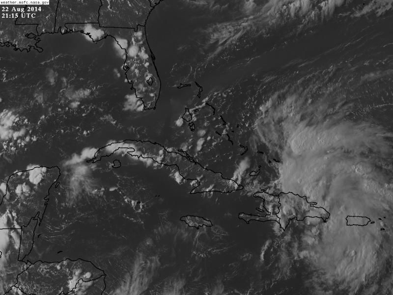
Yep, here's that special advisory just in.
000
ABNT20 KNHC 222049
TWOAT
SPECIAL TROPICAL WEATHER OUTLOOK
NWS NATIONAL HURRICANE CENTER MIAMI FL
450 PM EDT FRI AUG 22 2014
For the North Atlantic...Caribbean Sea and the Gulf of Mexico:
Special outlook issued to discuss results of aircraft
reconnaissance mission.
Updated...An Air Force Reserve Hurricane Hunter aircraft is
continuing to investigate the area of disturbed weather moving
over and north of Puerto Rico and Hispaniola. Aircraft reports
indicate that the system is producing winds of tropical storm force
over the open waters north of those islands, although the aircraft
data and surface observations indicate that the system still lacks a
well-defined surface circulation. Given the lack of a well-defined
surface circulation, tropical cyclone advisories are not being
initiated at this time.
The overall organization of the showers and thunderstorms has been
increasing today, but the proximity of the system to Hispaniola
could limit development tonight. Conditions for development are
expected to be more conducive when the disturbance moves near or
over the southeastern Bahamas on Saturday. Gusty winds and heavy
rains are expected across Puerto Rico and the Virgin Islands
tonight, and over portions of Hispaniola and the southeastern and
central Bahamas tonight and Saturday. Interests in the southeastern
and central Bahamas should monitor the progress of this disturbance,
since tropical storm watches or warnings could be required with
little advance notice.
* Formation chance through 48 hours...high...70 percent.
* Formation chance through 5 days...high...80 percent.
$$
Forecaster Franklin/Brennan
0 likes
Andy D
(For official information, please refer to the NHC and NWS products.)
(For official information, please refer to the NHC and NWS products.)
-
ScottNAtlanta

- Category 5

- Posts: 2535
- Joined: Sat May 25, 2013 3:11 pm
- Location: Atlanta, GA
Re: Re:
ScottNAtlanta wrote:NDG wrote:Nimbus wrote:Very easily seen low level clouds have thrashed around on the western side of the LLC twice now.
Small center is just north of the Punta Cana, Dominican Republic.
What I'm not sure about is what is going to happen with the high pressure over the CONUS?
Looks like there will be a westward jog in the storm track at the least in the near term. If the high rolls further east or splits there would be a weakness to take Crystobal out later, but I don't think the timing of that event can be modeled with certainty this far out.
If there was to be an LLC north of Punta Cana they would had not been reporting east winds. I think the vorticity is still above the ground, it is still a sharp trough of low pressure at the surface. Tomorrow morning is when I think it will finally start developing an LLC, once it slows down like others have mentioned.
They are currently reporting WNW winds at Punta Gorda
The problem is that your Punta Gorda is in SW Florida not the Dominican Republic
0 likes
The posts in this forum are NOT official forecast and should not be used as such. They are just the opinion of the poster and may or may not be backed by sound meteorological data. They are NOT endorsed by any professional institution or storm2k.org. For official information, please refer to the NHC and NWS products.
-
Aric Dunn
- Category 5
- Posts: 21238
- Age: 43
- Joined: Sun Sep 19, 2004 9:58 pm
- Location: Ready for the Chase.
- Contact:
Re: ATL: INVEST 96L - Discussion
NDG wrote:Aric Dunn wrote:watch in this area before recon leaves..
If there is a developing LLC in that circled area it looks like is fairly close to the coast, notice how the pressure readings were lower further south after they reported the wind shift.
it is the most probably area ... and there are a few indications it maybe closing off over the next couple hours.
0 likes
Note: If I make a post that is brief. Please refer back to previous posts for the analysis or reasoning. I do not re-write/qoute what my initial post said each time.
If there is nothing before... then just ask
Space & Atmospheric Physicist, Embry-Riddle Aeronautical University,
I believe the sky is falling...
If there is nothing before... then just ask
Space & Atmospheric Physicist, Embry-Riddle Aeronautical University,
I believe the sky is falling...
-
jlauderdal
- S2K Supporter
- Posts: 7240
- Joined: Wed May 19, 2004 5:46 am
- Location: NE Fort Lauderdale
- Contact:
Re:
Weatherboy1 wrote:I find it very hard to imagine this thing doesn't get designated today. The overall satellite presentation is the best yet, we've had hours and hours of sustained convection, and it's in a relatively favorable environment. We shall see! (Just my opinion and all that jazz!)
need a center at the surface for designation...it might look like a 5 on sat but if nothing doing at the surface then no designation
0 likes
-
northjaxpro

- S2K Supporter
- Posts: 8900
- Joined: Mon Sep 27, 2010 11:21 am
- Location: Jacksonville, FL
Not an official forecast of course, but I am inclined to think that 96L will get its act finaly together within the next 12 hours once it pulls farther away off the northern coast of Hispaniola.
Once 96L enters the SE Bahamas, and slows its forward speed, a definitive LLC will emerge and an upgrade will come.
However, I am very surprised like most of you how fast it has moved up to this point. That in itself has been amazing. It has to slopw down at some point very soon, especially with the steering pattern forecast to really weaken in the Bahamas region and SW Atlantic within the next 36-48 hours.
Last edited by northjaxpro on Fri Aug 22, 2014 4:10 pm, edited 1 time in total.
0 likes
NEVER, EVER SAY NEVER in the tropics and weather in general, and most importantly, with life itself!!
________________________________________________________________________________________
Fay 2008 Beryl 2012 Debby 2012 Colin 2016 Hermine 2016 Julia 2016 Matthew 2016 Irma 2017 Dorian 2019
________________________________________________________________________________________
Fay 2008 Beryl 2012 Debby 2012 Colin 2016 Hermine 2016 Julia 2016 Matthew 2016 Irma 2017 Dorian 2019
Re: ATL: INVEST 96L - Discussion
Aric Dunn wrote:NDG wrote:Aric Dunn wrote:watch in this area before recon leaves..
https://imageshack.com/a/img902/8665/lq0Axc.gif
If there is a developing LLC in that circled area it looks like is fairly close to the coast, notice how the pressure readings were lower further south after they reported the wind shift.
it is the most probably area ... and there are a few indications it maybe closing off over the next couple hours.
I am not saying your circled area is not it, I am just saying that it looks to be very close to the DR coast, NW of Punta Cana, approaching that little peninsula strip by Samana Bay, surface report just west of it is now reporting NW winds.
0 likes
Re: ATL: INVEST 96L - Discussion
NDG wrote:Aric Dunn wrote:NDG wrote:
If there is a developing LLC in that circled area it looks like is fairly close to the coast, notice how the pressure readings were lower further south after they reported the wind shift.
it is the most probably area ... and there are a few indications it maybe closing off over the next couple hours.
I am not saying your circled area is not it, I am just saying that it looks to be very close to the DR coast, NW of Punta Cana, approaching that little peninsula strip by Samana Bay, surface report just west of it is now reporting NW winds.
There is a station by Samana Bay NW of Punta Cana where the possible LLC is approaching now reporting calm winds with a pressure of 1005 mb.
0 likes

-
Bocadude85

- Category 5
- Posts: 2991
- Age: 39
- Joined: Mon Apr 18, 2005 2:20 pm
- Location: Honolulu,Hi
Re:
northjaxpro wrote:Not an official forecast of course, but I am inclined to think that 96L will get its act finaly together within the next 12 hours once it pulls farther away off the northern coast of Hispaniola.
Once 96L enters the SE Bahamas, and slows its forward speed, a definitive LLC will emerge and an upgrade will come.
However, I am very surprised like most of you how fast it has moved up to this point. That in itself has been amazing. It has to slopw down at some point very soon, especially with the steering pattern forecast to really weaken in the Bahamas region and SW Atlantic within the next 36-48 hours.
We'll if it doesn't slow down soon 96L will be in the Bahamas by tomorrow morning... Gotta wonder how far west this would get if it takes a little longer then forecast to slow down. I mean is the 12z CMC out of the realm of possibilities?
0 likes

Re: ATL: INVEST 96L - Discussion
TheStormExpert wrote:SFLcane wrote:Bocadude85 wrote:Is it me or does 96l seem to be moving quicker then the models have forecast?
yea that's key might miss trof if it doesn't slow down.
I still see this recurring one way or the other. Like many (including me) have said, these troughs have been abnormally strong this summer and that pattern is just going to keep going on IMO.
This isn't really true expert. Up until early August, you could have made that argument. And you could still argue that you expect troughiness off the East Coast. But this is a different source region, a different orientation and different implications. And as some have said for the last few weeks was that things have changed. Troughs have begun to lift out sending only weak or washing out boundaries to the Gulf South. So instead of being under a stalled front or north of one, I'm sitting here at a toasty 96 or so under upper level and surface high pressure. Look at the modeling and you aren't seeing a winter type trough as some have alluded that we have been and will remain in a winter pattern which was also bogus. At times maybe. Semi permanent? Perhaps. But this is middle of summer, and just as the mean trough axis in the Eastern US has been migrating west (see increased rainfall progressively backing west through Texas the last several weeks), we have not reached oceanic high tide for summer Atlantic ridging. We may see an occasional front over the next several weeks but don't expect anything abnormally strong until that first blast of fall or in a one off scenario.
0 likes
-
SeGaBob
This looks to be steadily organizing to me... (for now anyway) I could see a TS designation by 11pm or 5am if trends continue.
Personal Forecast Disclaimer:
The posts in this forum are NOT official forecast and should not be used as such. They are just the opinion of the poster and may or may not be backed by sound meteorological data. They are NOT endorsed by any professional institution or storm2k.org. For official information, please refer to the NHC and NWS products.
0 likes
-
jlauderdal
- S2K Supporter
- Posts: 7240
- Joined: Wed May 19, 2004 5:46 am
- Location: NE Fort Lauderdale
- Contact:
Re:
NDG wrote:Interesting that as soon as those 18z tropical models came out Orlando's WFTV Met is now saying FL is not out tof the woods yet, lol.
that met is an lbar and gfs hugger..lol
Last edited by jlauderdal on Fri Aug 22, 2014 5:29 pm, edited 1 time in total.
0 likes
-
Hurricane Andrew

- S2K Supporter
- Posts: 1891
- Age: 27
- Joined: Sun May 23, 2010 2:53 pm
- Location: KS
-
floridasun78
- Category 5
- Posts: 3755
- Joined: Sun May 17, 2009 10:16 pm
- Location: miami fl

Who is online
Users browsing this forum: No registered users and 32 guests