ATL: CRISTOBAL - Models
Moderator: S2k Moderators

Re: ATL: INVEST 96L - Models
It's really hard for me to believe that the ridge has not built Eastward enough to push the storm toward the Carolinas?
0 likes
Andy D
(For official information, please refer to the NHC and NWS products.)
(For official information, please refer to the NHC and NWS products.)
-
Bocadude85

- Category 5

- Posts: 2991
- Age: 39
- Joined: Mon Apr 18, 2005 2:20 pm
- Location: Honolulu,Hi
-
tolakram
- Admin

- Posts: 20186
- Age: 62
- Joined: Sun Aug 27, 2006 8:23 pm
- Location: Florence, KY (name is Mark)
Re: ATL: INVEST 96L - Models
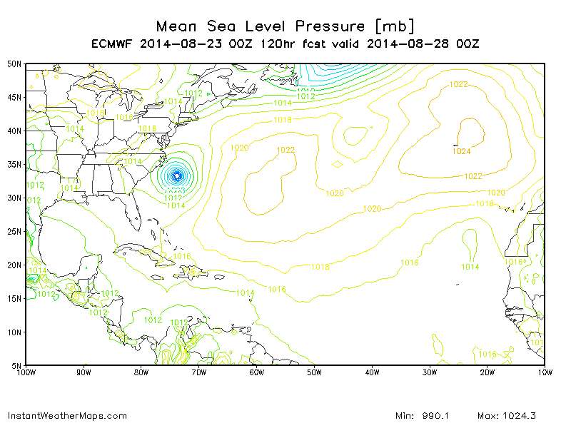
120h
0 likes
M a r k
- - - - -
Join us in chat: Storm2K Chatroom Invite. Android and IOS apps also available.
The posts in this forum are NOT official forecasts and should not be used as such. Posts are NOT endorsed by any professional institution or STORM2K.org. For official information and forecasts, please refer to NHC and NWS products.
-
tolakram
- Admin
- Posts: 20186
- Age: 62
- Joined: Sun Aug 27, 2006 8:23 pm
- Location: Florence, KY (name is Mark)
Re: ATL: INVEST 96L - Models
Previous run for comparison

0 likes
M a r k
- - - - -
Join us in chat: Storm2K Chatroom Invite. Android and IOS apps also available.
The posts in this forum are NOT official forecasts and should not be used as such. Posts are NOT endorsed by any professional institution or STORM2K.org. For official information and forecasts, please refer to NHC and NWS products.
- - - - -
Join us in chat: Storm2K Chatroom Invite. Android and IOS apps also available.
The posts in this forum are NOT official forecasts and should not be used as such. Posts are NOT endorsed by any professional institution or STORM2K.org. For official information and forecasts, please refer to NHC and NWS products.
-
tolakram
- Admin
- Posts: 20186
- Age: 62
- Joined: Sun Aug 27, 2006 8:23 pm
- Location: Florence, KY (name is Mark)
Re: ATL: INVEST 96L - Models
HWRF 120h

0 likes
M a r k
- - - - -
Join us in chat: Storm2K Chatroom Invite. Android and IOS apps also available.
The posts in this forum are NOT official forecasts and should not be used as such. Posts are NOT endorsed by any professional institution or STORM2K.org. For official information and forecasts, please refer to NHC and NWS products.
- - - - -
Join us in chat: Storm2K Chatroom Invite. Android and IOS apps also available.
The posts in this forum are NOT official forecasts and should not be used as such. Posts are NOT endorsed by any professional institution or STORM2K.org. For official information and forecasts, please refer to NHC and NWS products.
-
tolakram
- Admin
- Posts: 20186
- Age: 62
- Joined: Sun Aug 27, 2006 8:23 pm
- Location: Florence, KY (name is Mark)
Re: ATL: INVEST 96L - Models
144h, escaping

0 likes
M a r k
- - - - -
Join us in chat: Storm2K Chatroom Invite. Android and IOS apps also available.
The posts in this forum are NOT official forecasts and should not be used as such. Posts are NOT endorsed by any professional institution or STORM2K.org. For official information and forecasts, please refer to NHC and NWS products.
- - - - -
Join us in chat: Storm2K Chatroom Invite. Android and IOS apps also available.
The posts in this forum are NOT official forecasts and should not be used as such. Posts are NOT endorsed by any professional institution or STORM2K.org. For official information and forecasts, please refer to NHC and NWS products.
Re: ATL: INVEST 96L - Models
Wow, you're right about the Euro - definitely farther west and a little slower too. As for the HWRF, how does this run compare to the previous one?
0 likes
Andy D
(For official information, please refer to the NHC and NWS products.)
(For official information, please refer to the NHC and NWS products.)
-
Bocadude85
- Category 5
- Posts: 2991
- Age: 39
- Joined: Mon Apr 18, 2005 2:20 pm
- Location: Honolulu,Hi
Re: ATL: INVEST 96L - Models
chaser1 wrote:Wow, you're right about the Euro - definitely farther west and a little slower too. As for the HWRF, how does this run compare to the previous one?
The 0z HWRF is much further west then the 18z. And as far as the Euro goes definitely a decent west shift in the short range. The ridging came pretty close to shoving the system west in the 72hour time frame on the Euro.
Last edited by Bocadude85 on Sat Aug 23, 2014 1:34 am, edited 1 time in total.
0 likes
-
Evil Jeremy

- S2K Supporter

- Posts: 5463
- Age: 32
- Joined: Mon Apr 10, 2006 2:10 pm
- Location: Los Angeles, CA
Re: ATL: INVEST 96L - Models
chaser1 wrote:Wow, you're right about the Euro - definitely farther west and a little slower too. As for the HWRF, how does this run compare to the previous one?
More west than the 18z, but not as west as it was in earlier runs.
0 likes
Frances 04 / Jeanne 04 / Katrina 05 / Wilma 05 / Fay 08 / Debby 12 / Andrea 13 / Colin 16 / Hermine 16 / Matthew 16 / Irma 17
-
tolakram
- Admin
- Posts: 20186
- Age: 62
- Joined: Sun Aug 27, 2006 8:23 pm
- Location: Florence, KY (name is Mark)
Re: ATL: INVEST 96L - Models
168h, flying EAST and racking up ACE

0 likes
M a r k
- - - - -
Join us in chat: Storm2K Chatroom Invite. Android and IOS apps also available.
The posts in this forum are NOT official forecasts and should not be used as such. Posts are NOT endorsed by any professional institution or STORM2K.org. For official information and forecasts, please refer to NHC and NWS products.
- - - - -
Join us in chat: Storm2K Chatroom Invite. Android and IOS apps also available.
The posts in this forum are NOT official forecasts and should not be used as such. Posts are NOT endorsed by any professional institution or STORM2K.org. For official information and forecasts, please refer to NHC and NWS products.
-
tolakram
- Admin
- Posts: 20186
- Age: 62
- Joined: Sun Aug 27, 2006 8:23 pm
- Location: Florence, KY (name is Mark)
Re: ATL: INVEST 96L - Models
I'm done, goodnight!
0 likes
M a r k
- - - - -
Join us in chat: Storm2K Chatroom Invite. Android and IOS apps also available.
The posts in this forum are NOT official forecasts and should not be used as such. Posts are NOT endorsed by any professional institution or STORM2K.org. For official information and forecasts, please refer to NHC and NWS products.
- - - - -
Join us in chat: Storm2K Chatroom Invite. Android and IOS apps also available.
The posts in this forum are NOT official forecasts and should not be used as such. Posts are NOT endorsed by any professional institution or STORM2K.org. For official information and forecasts, please refer to NHC and NWS products.

 108 hr hwrf
Re: ATL: INVEST 96L - Models
Time to gas up the generator just in case. We will have a good feel by Sunday how strong that ridge will be.
0 likes
The following post is NOT an official forecast and should not be used as such. It is just the opinion of the poster and may or may not be backed by sound meteorological data. It is NOT endorsed by any professional institution including storm2k.org For Official Information please refer to the NHC and NWS products.

-
southerngale

- Retired Staff

- Posts: 27418
- Joined: Thu Oct 10, 2002 1:27 am
- Location: Southeast Texas (Beaumont area)
Re: ATL: INVEST 96L - Models
GFS 06z @ 96h

0 likes
Please support Storm2k by making a donation today. It is greatly appreciated! Click here: 
 my Cowboys my Rockets my Astros
my Cowboys my Rockets my Astros-
southerngale
- Retired Staff
- Posts: 27418
- Joined: Thu Oct 10, 2002 1:27 am
- Location: Southeast Texas (Beaumont area)
Re: ATL: INVEST 96L - Models
GFS 06z @ 120h

0 likes
Please support Storm2k by making a donation today. It is greatly appreciated! Click here:
my Cowboys my Rockets my Astros
my Cowboys my Rockets my Astros
it also appears to be quite a bit weaker.
I do not foresee any rapid intensification. The building upper high to the nrothwest of the system should restrict the outflow. Instead, only gradual intensification appears likely in the Bahamas. Still likely will gt a hurricane out of this. However, it may be more akin to Erin in 1995 vs a major hurricane
I do not foresee any rapid intensification. The building upper high to the nrothwest of the system should restrict the outflow. Instead, only gradual intensification appears likely in the Bahamas. Still likely will gt a hurricane out of this. However, it may be more akin to Erin in 1995 vs a major hurricane
0 likes

-
southerngale
- Retired Staff
- Posts: 27418
- Joined: Thu Oct 10, 2002 1:27 am
- Location: Southeast Texas (Beaumont area)
Re:
bahamaswx wrote:Can you post a link to where I can find these models? I lost my bookmarks long ago.
The one I just posted from is http://www.instantweathermaps.com/. It can be found at the top of this page under Model Sites.
0 likes
Please support Storm2k by making a donation today. It is greatly appreciated! Click here:
my Cowboys my Rockets my Astros
my Cowboys my Rockets my AstrosWho is online
Users browsing this forum: No registered users and 31 guests