SeGaBob wrote:I could see this thread getting 80-100 pages by the time this storm is done with. (especially if it impacts FL)
This thing hits Florida, we hit 500 pages easily.
Moderator: S2k Moderators


SeGaBob wrote:I could see this thread getting 80-100 pages by the time this storm is done with. (especially if it impacts FL)


emeraldislenc wrote:Once the center forms and we know exactly where the center is do you think the models will have a better handle on the storm?


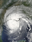
tolakram wrote:30 frame visible, speed it up for full effect. I see more organization./shrug
http://wwwghcc.msfc.nasa.gov/cgi-bin/get-goes?satellite=GOES-E%20CONUS&lat=21&lon=-72&info=vis&zoom=1&width=1200&height=700&quality=95&type=Animation&palette=ir1.pal&numframes=30
Evil Jeremy wrote:tolakram wrote:30 frame visible, speed it up for full effect. I see more organization.
http://wwwghcc.msfc.nasa.gov/cgi-bin/get-goes?satellite=GOES-E%20CONUS&lat=21&lon=-72&info=vis&zoom=1&width=1200&height=700&quality=95&type=Animation&palette=ir1.pal&numframes=30
It's almost there. Just needs a little spark. I think today is the day 96L finally gets it's act together.


tolakram wrote:30 frame visible, speed it up for full effect. I see more organization.
http://wwwghcc.msfc.nasa.gov/cgi-bin/get-goes?satellite=GOES-E%20CONUS&lat=21&lon=-72&info=vis&zoom=1&width=1200&height=700&quality=95&type=Animation&palette=ir1.pal&numframes=30


Users browsing this forum: No registered users and 30 guests