ATL: CRISTOBAL - Models

Moderator: S2k Moderators

Message
Author
User avatar
Bocadude85
Category 5
Category 5
Posts: 2991
Age: 38
Joined: Mon Apr 18, 2005 2:20 pm
Location: Honolulu,Hi

Re: ATL: INVEST 96L - Models

#1521 Postby Bocadude85 » Sat Aug 23, 2014 1:10 pm

tolakram wrote:[gif[/img]


That's a substantial southwest shift.
0 likes   

tolakram
Admin
Admin
Posts: 20009
Age: 62
Joined: Sun Aug 27, 2006 8:23 pm
Location: Florence, KY (name is Mark)

Re: ATL: INVEST 96L - Models

#1522 Postby tolakram » Sat Aug 23, 2014 1:11 pm

Well west of previous run now, but weaker.

Previous 72h frame, for reference.

Image

12Z 72h, which is for a later time

Image
0 likes   
M a r k
- - - - -
Join us in chat: Storm2K Chatroom Invite. Android and IOS apps also available.

The posts in this forum are NOT official forecasts and should not be used as such. Posts are NOT endorsed by any professional institution or STORM2K.org. For official information and forecasts, please refer to NHC and NWS products.

User avatar
SFLcane
S2K Supporter
S2K Supporter
Posts: 10163
Age: 47
Joined: Sat Jun 05, 2010 1:44 pm
Location: Lake Worth Florida

Re: ATL: INVEST 96L - Models

#1523 Postby SFLcane » Sat Aug 23, 2014 1:12 pm

Ridge over head could drift w

edit...Nope head north
Last edited by SFLcane on Sat Aug 23, 2014 1:14 pm, edited 1 time in total.
0 likes   

User avatar
southerngale
Retired Staff
Retired Staff
Posts: 27418
Joined: Thu Oct 10, 2002 1:27 am
Location: Southeast Texas (Beaumont area)

#1524 Postby southerngale » Sat Aug 23, 2014 1:14 pm

Euro @ 96h - moving N

Image
0 likes   
Please support Storm2k by making a donation today. It is greatly appreciated! Click here: Image

Image my Cowboys Image my RocketsImage my Astros

tolakram
Admin
Admin
Posts: 20009
Age: 62
Joined: Sun Aug 27, 2006 8:23 pm
Location: Florence, KY (name is Mark)

Re: ATL: INVEST 96L - Models

#1525 Postby tolakram » Sat Aug 23, 2014 1:15 pm

96h

Image
0 likes   
M a r k
- - - - -
Join us in chat: Storm2K Chatroom Invite. Android and IOS apps also available.

The posts in this forum are NOT official forecasts and should not be used as such. Posts are NOT endorsed by any professional institution or STORM2K.org. For official information and forecasts, please refer to NHC and NWS products.

TonyWeatherMan
Tropical Low
Tropical Low
Posts: 16
Joined: Sun Aug 17, 2014 11:22 am

#1526 Postby TonyWeatherMan » Sat Aug 23, 2014 1:15 pm

As I expected well weaker this run, ridge appears to continue to build. I suspect weaker than even the EURO is showing now as well.

Personal Forecast Disclaimer:
The posts in this forum are NOT official forecast and should not be used as such. They are just the opinion of the poster and may or may not be backed by sound meteorological data. They are NOT endorsed by any professional institution or storm2k.org. For official information, please refer to the NHC and NWS products.
Last edited by tolakram on Sat Aug 23, 2014 1:17 pm, edited 1 time in total.
Reason: added disclaimer
0 likes   

User avatar
chaser1
S2K Supporter
S2K Supporter
Posts: 5464
Age: 64
Joined: Sat Oct 15, 2005 5:59 pm
Location: Longwood, Fl

Re:

#1527 Postby chaser1 » Sat Aug 23, 2014 1:16 pm

TonyWeatherMan wrote:Already looks like a bunk run IMO. Do not think it will develop this fast. The timing of development will likely have a significant role in its future overall track I also think.


I respect your opinion and might even agree conceptually that continued development could impart a farther west motion. Where iI disagree is that you think it unreasonable for this system to deepen 1millibars over a 12 hour period? And, if there were even the slightest amount of further organization, you think it unreasonable to deepen a mere 2 millibars further - over the following 12 hours? A 3-MB fall in pressure within a vigorous tropical system, at the peak of the hurricane season over a 24 hours period... barely even qualifies as anything other than slight organization and intensification. Heck, 100 people on a cruise to Nassau could practically "fart", and cause a 1 mb drop in pressure :ggreen:
0 likes   
Andy D

(For official information, please refer to the NHC and NWS products.)

User avatar
SFLcane
S2K Supporter
S2K Supporter
Posts: 10163
Age: 47
Joined: Sat Jun 05, 2010 1:44 pm
Location: Lake Worth Florida

Re: ATL: INVEST 96L - Models

#1528 Postby SFLcane » Sat Aug 23, 2014 1:17 pm

GFDL ensembles..

Image
0 likes   

floridasun78
Category 5
Category 5
Posts: 3755
Joined: Sun May 17, 2009 10:16 pm
Location: miami fl

Re: ATL: INVEST 96L - Models

#1529 Postby floridasun78 » Sat Aug 23, 2014 1:20 pm

SFLcane wrote:GFDL ensembles..

Image

that look good for fl :sun:
0 likes   

TonyWeatherMan
Tropical Low
Tropical Low
Posts: 16
Joined: Sun Aug 17, 2014 11:22 am

Re: Re:

#1530 Postby TonyWeatherMan » Sat Aug 23, 2014 1:20 pm

chaser1 wrote:
TonyWeatherMan wrote:Already looks like a bunk run IMO. Do not think it will develop this fast. The timing of development will likely have a significant role in its future overall track I also think.


I respect your opinion and might even agree conceptually that continued development could impart a farther west motion. Where iI disagree is that you think it unreasonable for this system to deepen 1millibars over a 12 hour period? And, if there were even the slightest amount of further organization, you think it unreasonable to deepen a mere 2 millibars further - over the following 12 hours? A 3-MB fall in pressure within a vigorous tropical system, at the peak of the hurricane season over a 24 hours period... barely even qualifies as anything other than slight organization and intensification. Heck, 100 people on a cruise to Nassau could practically "fart", and cause a 1 mb drop in pressure :ggreen:


Sure that's a fair point, but to answer that question i'd counter with after all this time why hasn't it deepened yet? Models have consistently shown deepening and it hasn't happened. I see nothing to suggest otherwise. No LLC has formed, convection doesn't qualify for an upgrade, and marginal conditions ahead of it. Let's face it we are struggling to find the C storm....it's August 23rd.


So in conclusion do I think it's possible? Absolutely.
0 likes   

User avatar
SFLcane
S2K Supporter
S2K Supporter
Posts: 10163
Age: 47
Joined: Sat Jun 05, 2010 1:44 pm
Location: Lake Worth Florida

Re: ATL: INVEST 96L - Models

#1531 Postby SFLcane » Sat Aug 23, 2014 1:20 pm

12z UKMET through sfl..

Image
0 likes   

tolakram
Admin
Admin
Posts: 20009
Age: 62
Joined: Sun Aug 27, 2006 8:23 pm
Location: Florence, KY (name is Mark)

Re: ATL: INVEST 96L - Models

#1532 Postby tolakram » Sat Aug 23, 2014 1:20 pm

And escaping at 120h

Image
0 likes   
M a r k
- - - - -
Join us in chat: Storm2K Chatroom Invite. Android and IOS apps also available.

The posts in this forum are NOT official forecasts and should not be used as such. Posts are NOT endorsed by any professional institution or STORM2K.org. For official information and forecasts, please refer to NHC and NWS products.

User avatar
gatorcane
S2K Supporter
S2K Supporter
Posts: 23691
Age: 47
Joined: Sun Mar 13, 2005 3:54 pm
Location: Boca Raton, FL

Re: ATL: INVEST 96L - Models

#1533 Postby gatorcane » Sat Aug 23, 2014 1:21 pm

SFLcane wrote:12z UKMET through sfl..

Good grief thought it joined the recurve camp. Guess not.
0 likes   

tolakram
Admin
Admin
Posts: 20009
Age: 62
Joined: Sun Aug 27, 2006 8:23 pm
Location: Florence, KY (name is Mark)

Re: Re:

#1534 Postby tolakram » Sat Aug 23, 2014 1:21 pm

TonyWeatherMan wrote:Sure that's a fair point, but to answer that question i'd counter with after all this time why hasn't it deepened yet? Models have consistently shown deepening and it hasn't happened. I see nothing to suggest otherwise. No LLC has formed, convection doesn't qualify for an upgrade, and marginal conditions ahead of it. Let's face it we are struggling to find the C storm....it's August 23rd.


So in conclusion do I think it's possible? Absolutely.


Hi Tony,

what models showed it deepening today? Also, please add the disclaimer if you are making a prediction. Thanks.
0 likes   
M a r k
- - - - -
Join us in chat: Storm2K Chatroom Invite. Android and IOS apps also available.

The posts in this forum are NOT official forecasts and should not be used as such. Posts are NOT endorsed by any professional institution or STORM2K.org. For official information and forecasts, please refer to NHC and NWS products.

User avatar
DESTRUCTION5
Category 5
Category 5
Posts: 4423
Age: 43
Joined: Wed Sep 03, 2003 11:25 am
Location: Stuart, FL

Re: ATL: INVEST 96L - Models

#1535 Postby DESTRUCTION5 » Sat Aug 23, 2014 1:22 pm

gatorcane wrote:
SFLcane wrote:12z UKMET through sfl..

Good grief thought it joined the recurve camp. Guess not.


All but the Euro have trended west...we roll on to the next suite of modeling.
0 likes   
GATOR NATION IS E V E R Y W H E R E !

Tyler Penland
Tropical Depression
Tropical Depression
Posts: 63
Joined: Fri Aug 19, 2011 12:32 pm
Location: Blowing Rock, NC

Re: ATL: INVEST 96L - Models

#1536 Postby Tyler Penland » Sat Aug 23, 2014 1:22 pm

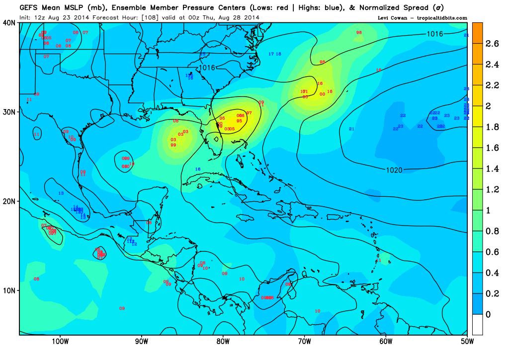
Zoomed in look at 12z GFS ensemble spread. Three very distinct camps.

Image
0 likes   
****The above is NOT AN OFFICIAL FORECAST. I am in no way affiliated with the NWS or storm2k, and most likely don't share their opinion. Please refer to NWS/NHC products for official advisories/warnings/forecasts.****

But if you insist, trust me, I'm a physicist.

User avatar
Bocadude85
Category 5
Category 5
Posts: 2991
Age: 38
Joined: Mon Apr 18, 2005 2:20 pm
Location: Honolulu,Hi

Re: ATL: INVEST 96L - Models

#1537 Postby Bocadude85 » Sat Aug 23, 2014 1:23 pm

SFLcane wrote:12z UKMET through sfl..

Image


That's a huge west shift for the UKMET
0 likes   

TheStormExpert

Re: ATL: INVEST 96L - Models

#1538 Postby TheStormExpert » Sat Aug 23, 2014 1:25 pm

DESTRUCTION5 wrote:
gatorcane wrote:
SFLcane wrote:12z UKMET through sfl..

Good grief thought it joined the recurve camp. Guess not.

All but the Euro have trended west...we roll on to the next suite of modeling.

The Euro trended slightly west.
0 likes   

User avatar
Bocadude85
Category 5
Category 5
Posts: 2991
Age: 38
Joined: Mon Apr 18, 2005 2:20 pm
Location: Honolulu,Hi

Re: ATL: INVEST 96L - Models

#1539 Postby Bocadude85 » Sat Aug 23, 2014 1:25 pm

DESTRUCTION5 wrote:
gatorcane wrote:
SFLcane wrote:12z UKMET through sfl..

Good grief thought it joined the recurve camp. Guess not.


All but the Euro have trended west...we roll on to the next suite of modeling.


Actually the euro has shifted west some in the first 3-4 days
0 likes   

TonyWeatherMan
Tropical Low
Tropical Low
Posts: 16
Joined: Sun Aug 17, 2014 11:22 am

Re: Re:

#1540 Postby TonyWeatherMan » Sat Aug 23, 2014 1:27 pm

tolakram wrote:
TonyWeatherMan wrote:Sure that's a fair point, but to answer that question i'd counter with after all this time why hasn't it deepened yet? Models have consistently shown deepening and it hasn't happened. I see nothing to suggest otherwise. No LLC has formed, convection doesn't qualify for an upgrade, and marginal conditions ahead of it. Let's face it we are struggling to find the C storm....it's August 23rd.


So in conclusion do I think it's possible? Absolutely.


Hi Tony,

what models showed it deepening today? Also, please add the disclaimer if you are making a prediction. Thanks.


Go check back and see for yourself. Just about every reliable computer model running including the GFS of course had a deeper storm than we are currently seeing 36+ hours back where 96L is currently. It's not a prediction as much as it's a simple fact that the storm has continued to stay weak, despite model forecasts. My opinion based upon this being this has resulted in the gradual west shift of all the reliable global models. Even the EURO we just looked at has continued to shift ever so slightly west, while keeping the storm weak.

Personal Forecast Disclaimer:
The posts in this forum are NOT official forecast and should not be used as such. They are just the opinion of the poster and may or may not be backed by sound meteorological data. They are NOT endorsed by any professional institution or storm2k.org. For official information, please refer to the NHC and NWS products.
0 likes   


Return to “2014”

Who is online

Users browsing this forum: No registered users and 0 guests