ATL: CRISTOBAL - Models
Moderator: S2k Moderators
-
SouthFLTropics

- Category 5

- Posts: 4258
- Age: 50
- Joined: Thu Aug 14, 2003 8:04 am
- Location: Port St. Lucie, Florida
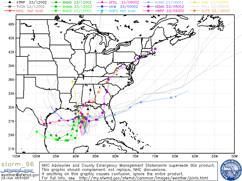
I can't remember the last time the models were this different in such a short time frame (5 days or less) forecast. They have been all over the place. They are having a very hard time getting a hold of the ridge vs trough setup.
0 likes
Fourth Generation Florida Native
Personal Storm History: David 79, Andrew 92, Erin 95, Floyd 99, Irene 99, Frances 04, Jeanne 04, Wilma 05, Matthew 16, Irma 17, Ian 22, Nicole 22, Milton 24
Personal Storm History: David 79, Andrew 92, Erin 95, Floyd 99, Irene 99, Frances 04, Jeanne 04, Wilma 05, Matthew 16, Irma 17, Ian 22, Nicole 22, Milton 24
-
Evil Jeremy

- S2K Supporter

- Posts: 5463
- Age: 32
- Joined: Mon Apr 10, 2006 2:10 pm
- Location: Los Angeles, CA
Re: ATL: INVEST 96L - Models
GFS and GFDL shifted a bit east but are still close to Florida, and CMC is now the Eastern outlier. Everything else moved a bit west.
Last edited by Evil Jeremy on Sat Aug 23, 2014 1:28 pm, edited 1 time in total.
0 likes
Frances 04 / Jeanne 04 / Katrina 05 / Wilma 05 / Fay 08 / Debby 12 / Andrea 13 / Colin 16 / Hermine 16 / Matthew 16 / Irma 17
-
tolakram
- Admin

- Posts: 20186
- Age: 62
- Joined: Sun Aug 27, 2006 8:23 pm
- Location: Florence, KY (name is Mark)
Re: ATL: INVEST 96L - Models
144h

0 likes
M a r k
- - - - -
Join us in chat: Storm2K Chatroom Invite. Android and IOS apps also available.
The posts in this forum are NOT official forecasts and should not be used as such. Posts are NOT endorsed by any professional institution or STORM2K.org. For official information and forecasts, please refer to NHC and NWS products.


-
jlauderdal
- S2K Supporter
- Posts: 7240
- Joined: Wed May 19, 2004 5:46 am
- Location: NE Fort Lauderdale
- Contact:
Re: ATL: INVEST 96L - Models
SouthFLTropics wrote:I can't remember the last time the models were this different in such a short time frame (5 days or less) forecast. They have been all over the place. They are having a very hard time getting a hold of the ridge vs trough setup.
not unusual when we dont have a coc
0 likes
-
tolakram
- Admin
- Posts: 20186
- Age: 62
- Joined: Sun Aug 27, 2006 8:23 pm
- Location: Florence, KY (name is Mark)
Re: ATL: INVEST 96L - Models
Overall I would say the euro trended east, with a slight delay in the right turn. Based on this model resolution and times it appears less of a thread to NC.
Personal Forecast Disclaimer:
The posts in this forum are NOT official forecast and should not be used as such. They are just the opinion of the poster and may or may not be backed by sound meteorological data. They are NOT endorsed by any professional institution or storm2k.org. For official information, please refer to the NHC and NWS products.
0 likes
M a r k
- - - - -
Join us in chat: Storm2K Chatroom Invite. Android and IOS apps also available.
The posts in this forum are NOT official forecasts and should not be used as such. Posts are NOT endorsed by any professional institution or STORM2K.org. For official information and forecasts, please refer to NHC and NWS products.
- - - - -
Join us in chat: Storm2K Chatroom Invite. Android and IOS apps also available.
The posts in this forum are NOT official forecasts and should not be used as such. Posts are NOT endorsed by any professional institution or STORM2K.org. For official information and forecasts, please refer to NHC and NWS products.
-
Evil Jeremy
- S2K Supporter
- Posts: 5463
- Age: 32
- Joined: Mon Apr 10, 2006 2:10 pm
- Location: Los Angeles, CA
Re:
SouthFLTropics wrote:I can't remember the last time the models were this different in such a short time frame (5 days or less) forecast. They have been all over the place. They are having a very hard time getting a hold of the ridge vs trough setup.
Legends tell of a fellow 96L that caused confusion long ago..... in 2012 (http://flhurricane.com/images/2012/stor ... 3-0855.gif)
Gotta love Debby.
0 likes
Frances 04 / Jeanne 04 / Katrina 05 / Wilma 05 / Fay 08 / Debby 12 / Andrea 13 / Colin 16 / Hermine 16 / Matthew 16 / Irma 17

Re: Re:
I respect your opinion and might even agree conceptually that continued development could impart a farther west motion. Where iI disagree is that you think it unreasonable for this system to deepen 1millibars over a 12 hour period? And, if there were even the slightest amount of further organization, you think it unreasonable to deepen a mere 2 millibars further - over the following 12 hours? A 3-MB fall in pressure within a vigorous tropical system, at the peak of the hurricane season over a 24 hours period... barely even qualifies as anything other than slight organization and intensification. Heck, 100 people on a cruise to Nassau could practically "fart", and cause a 1 mb drop in pressure
Sure that's a fair point, but to answer that question i'd counter with after all this time why hasn't it deepened yet? Models have consistently shown deepening and it hasn't happened. I see nothing to suggest otherwise. No LLC has formed, convection doesn't qualify for an upgrade, and marginal conditions ahead of it. Let's face it we are struggling to find the C storm....it's August 23rd.
So in conclusion do I think it's possible? Absolutely.
Well, we will agree on this point for sure. There is no reason to assume that synoptics will improve enough to guarantee that 96L will "absolutely" develop into a tropical storm at any point...however such conditions are forecast to become more favorable in about 24 hours. On the other hand, it would be an entirely incorrect statement to call this a bunk 12Z run on the basis that it may or may not incur a 3 MB drop in pressure over a 24 h
0 likes
Andy D
(For official information, please refer to the NHC and NWS products.)
(For official information, please refer to the NHC and NWS products.)
-
Bocadude85

- Category 5
- Posts: 2991
- Age: 39
- Joined: Mon Apr 18, 2005 2:20 pm
- Location: Honolulu,Hi
Re: ATL: INVEST 96L - Models
I think the models are slowly coming together on a solution. I'm thinking this moves slowly WNW into the Northwest Bahamas before turning north and then finally NE and out to sea.
Personal Forecast Disclaimer:
The posts in this forum are NOT official forecast and should not be used as such. They are just the opinion of the poster and may or may not be backed by sound meteorological data. They are NOT endorsed by any professional institution or storm2k.org. For official information, please refer to the NHC and NWS products.
0 likes
-
DESTRUCTION5

- Category 5
- Posts: 4430
- Age: 44
- Joined: Wed Sep 03, 2003 11:25 am
- Location: Stuart, FL
Re: ATL: INVEST 96L - Models
Bocadude85 wrote:I think the models are slowly coming together on a solution. I'm thinking this moves slowly WNW into the Northwest Bahamas before turning north and then finally NE and out to sea.
Agreed ..I think it just matters now how close it gets to FL and what if any affects come from it before it exits...Bahamas being soaked is a given.
0 likes
GATOR NATION IS E V E R Y W H E R E !
Re: ATL: INVEST 96L - Models
tolakram wrote: Overall I would say the euro trended east, with a slight delay in the right turn. Based on this model resolution and times it appears less of a thread to NC.
Mark, that's absolutely true.... however the updated 12Z part of the forecast through 72 hours would actually tend to show a greater potential risk to South Florida as the near term trend now indicates a perilous stall in the Bahamas where earlier runs had the storm further north.
0 likes
Andy D
(For official information, please refer to the NHC and NWS products.)
(For official information, please refer to the NHC and NWS products.)
-
Evil Jeremy
- S2K Supporter
- Posts: 5463
- Age: 32
- Joined: Mon Apr 10, 2006 2:10 pm
- Location: Los Angeles, CA
Re: ATL: INVEST 96L - Models
chaser1 wrote:tolakram wrote: Overall I would say the euro trended east, with a slight delay in the right turn. Based on this model resolution and times it appears less of a thread to NC.
Mark, that's absolutely true.... however the updated 12Z part of the forecast through 72 hours would actually tend to show a greater potential risk to South Florida as the near term trend now indicates a perilous stall in the Bahamas where earlier runs had the storm further north.
My take away from this (as an amateur) is that in this run, 96L is closer to missing the recurve alltogether, even though it does end up getting caught.
0 likes
Frances 04 / Jeanne 04 / Katrina 05 / Wilma 05 / Fay 08 / Debby 12 / Andrea 13 / Colin 16 / Hermine 16 / Matthew 16 / Irma 17
-
TheStormExpert


-
SeGaBob
-
SouthFLTropics
- Category 5
- Posts: 4258
- Age: 50
- Joined: Thu Aug 14, 2003 8:04 am
- Location: Port St. Lucie, Florida
The ball on a hill analogy has been a very good one. It will hit that fork in road and will go one way or another. A similar analogy would be from Jeff Goldblum in Jurrasic Park when he was explaining the chaos theory with a drop of water on Laura Dern's hand. Chaos theory would be something that the models wouldn't pick up such as slight variations in the atmosphere, etc. this could go either way.
0 likes
Fourth Generation Florida Native
Personal Storm History: David 79, Andrew 92, Erin 95, Floyd 99, Irene 99, Frances 04, Jeanne 04, Wilma 05, Matthew 16, Irma 17, Ian 22, Nicole 22, Milton 24
Personal Storm History: David 79, Andrew 92, Erin 95, Floyd 99, Irene 99, Frances 04, Jeanne 04, Wilma 05, Matthew 16, Irma 17, Ian 22, Nicole 22, Milton 24
Who is online
Users browsing this forum: No registered users and 30 guests