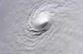
blp wrote:Wow amazing blow-up. This what makes the tropics so interesting.
Yeah this is really exploding. Due to its large size I'd be battening down the hatches in Bermuda.
Moderator: S2k Moderators

blp wrote:Wow amazing blow-up. This what makes the tropics so interesting.
gatorcane wrote:Looks like the ECMWF which predicted it to strengthen quite quickly from today through extra-tropical transition is verifying. In fact the ECMWF develops an extra-tropical monster out of this starting around 96 hours in the North Atlantic. What a wonderful job the ECMWF did on this system while the rest of the models waivered around with little consistency.
ozonepete wrote:TARHEELPROGRAMMER wrote:I hear that Ozonepete it is just weird in the way it has been moving. I will keep one eye on this storm until it is clearly gone.
Yeah it had some really erratic movement over the last 24 hours. And yes, in your neck of the woods I would never take my eye off one of these until it passes east of me.
ozonepete wrote:trave2 wrote:So why does a huge trough come down and cause onshore easterly winds along the whole Atlantic seaboard in the middle of August? Just when the first storm with any strength of the season is encroaching on the Continental U.S.? Interesting, just like the water vapor imagery for the last 48 hours. This plan just might backfire on them if it does not get picked up by the unseasonable backdoor front that came down from the north Atlantic
This has happened more than a few times in the last few years and it's not uncommon at the end of August at all. so I wouldn't really call it that unseasonable, despite what the weather channel says. This is not some unusually cold air mass by any stretch of the imagination. No record lows are being set and as a matter of fact here in NYC it was 88F today. The normal high is 82F. Look at the temps and dewpoints out at Bermuda and north of Cristobal. Temps are in the 80s and dewpoints in the70s. This continental polar air mass has already been modified into a maritime tropical air mass over the Atlantic offshore of the eastern U.S.
trave2 wrote:ozonepete wrote:trave2 wrote:So why does a huge trough come down and cause onshore easterly winds along the whole Atlantic seaboard in the middle of August? Just when the first storm with any strength of the season is encroaching on the Continental U.S.? Interesting, just like the water vapor imagery for the last 48 hours. This plan just might backfire on them if it does not get picked up by the unseasonable backdoor front that came down from the north Atlantic
This has happened more than a few times in the last few years and it's not uncommon at the end of August at all. so I wouldn't really call it that unseasonable, despite what the weather channel says. This is not some unusually cold air mass by any stretch of the imagination. No record lows are being set and as a matter of fact here in NYC it was 88F today. The normal high is 82F. Look at the temps and dewpoints out at Bermuda and north of Cristobal. Temps are in the 80s and dewpoints in the70s. This continental polar air mass has already been modified into a maritime tropical air mass over the Atlantic offshore of the eastern U.S.
I have not watched the Weather Channel since the 90's. I was not talking about the temp. just the location, strength, and duration on the upper level winds. This " modified into a maritime tropical air mass over the Atlantic offshore of the eastern U.S" is not the norm. This would have been a very bad storm if this "maritime tropical air mass over the Atlantic offshore of the eastern U.S" would not have appeared out of know where.

euro6208 wrote:When will the Atlantic have hurricanes that actually looked like hurricanes?
Oh Dvorak so far? Only 2.0 and likely only a depression if it were somewhere else.


Hammy wrote:First recon pass doesn't seem to support hurricane intensity, highest SFMR is 59kts.
05:43:00Z 24.683N 73.467W 842.9 mb
(~ 24.89 inHg) 1,502 meters
(~ 4,928 feet) 1000.6 mb
(~ 29.55 inHg) - From 310° at 28 knots
(From the NW at ~ 32.2 mph)
Riptide wrote:Hammy wrote:First recon pass doesn't seem to support hurricane intensity, highest SFMR is 59kts.
Did they miss the center to the east? They are below 25N and no south winds yet.05:43:00Z 24.683N 73.467W 842.9 mb
(~ 24.89 inHg) 1,502 meters
(~ 4,928 feet) 1000.6 mb
(~ 29.55 inHg) - From 310° at 28 knots
(From the NW at ~ 32.2 mph)

Users browsing this forum: No registered users and 19 guests


