ATL: INVEST 98L - Discussion
Moderator: S2k Moderators
Re: ATL: INVEST 98L - Discussion
Thanks Portastorm. I missed your pos yesterday but it is uncanny how often systems tighten up hitting Texas. Models often even anticipate that nowadays .
0 likes
-
Stormcenter
- S2K Supporter

- Posts: 6689
- Joined: Wed Sep 03, 2003 11:27 am
- Location: Houston, TX
Re: ATL: INVEST 98L - Discussion
Tightening up?
Steve wrote:Thanks Portastorm. I missed your pos yesterday but it is uncanny how often systems tighten up hitting Texas. Models often even anticipate that nowadays .
0 likes
- Tireman4
- S2K Supporter

- Posts: 5903
- Age: 60
- Joined: Fri Jun 30, 2006 1:08 pm
- Location: Humble, Texas
- Contact:
From HGX NWS AFD this morning:
AVIATION...
ANOTHER DAY OF SHOWERS AND THUNDERSTORMS WILL BE POSSIBLE ACROSS
THE TAF SITES THIS AFTERNOON. MOSTLY VFR CONDITIONS SHOULD PREVAIL EXCEPT
INSIDE SHOWERS AND THUNDERSTORMS WHERE VISIBILITIES COULD BE
SIGNIFICANTLY REDUCED. TOMORROW THERE APPEARS TO BE ANOTHER CHANCE
OF SHOWERS AND THUNDERSTORMS THANKS TO REMAINING UPPER LEVEL
ENERGY. HIGH RES TEXAS TECH WRF MODEL SHOWING PRETTY GOOD AREAL
COVERAGE TOMORROW THANKS TO HIGH PWAT AIR. FOR NOW VICINITY
SHOWERS AND THUNDERSTORMS APPEARS TO HAVE THIS COVERED. 23
&&
.PREV DISCUSSION... /ISSUED 1028 AM CDT THU AUG 28 2014/
DISCUSSION...
THANKS TO THE WEAK LOW OFF THE SOUTHERN TEXAS COAST AREAS OF
SHOWERS AND THUNDERSTORMS HAVE DEVELOPED IN PLACES ALONG THE UPPER
TEXAS COAST AND ACROSS THE COASTAL WATERS. SOME TRAINING HAS BEEN
OBSERVED RESULTING IN RADAR RAIN TOTALS OF 2 TO 4 INCHES IN SOME
PLACES. SO FAR RAINS HAVE BEEN CONFINED MAINLY NEAR THE COAST
WHERE THE COLDEST CLOUD TOPS ARE. UNLIKE YESTERDAY THERE`S A
HIGHER CHANCE TODAY OF INLAND STORMS...HOWEVER NOT REAL CONFIDENT
HOW FAR INLAND THE STORMS WILL GO. FOR THE MORNING UPDATE...WENT
AHEAD AND RAISED RAIN CHANCES A LITTLE BIT BASED ON RADAR TRENDS.
ALSO LOWERED AFTERNOON TEMPS A COUPLE DEGREES FOR AREAS ALONG THE
COAST WHERE CLOUD COVER AND RAIN WILL KEEP IT COOLER. FURTHER TO
THE NORTH CURRENT THINKING IS THAT AFTERNOON HIGHS WILL STILL
REACH THE MID 90`S AS LONG AS COASTAL CLOUD COVER STAYS SOUTH.
42/99
http://forecast.weather.gov/product.php ... glossary=1
0 likes
- cycloneye
- Admin

- Posts: 149550
- Age: 69
- Joined: Thu Oct 10, 2002 10:54 am
- Location: San Juan, Puerto Rico
Re: ATL: INVEST 98L - Discussion
Kaput.
Showers and thunderstorms along the coast of South Texas are
associated with a weak area of low pressure. This system is
forecast to move inland over southern Texas and northern
Mexico later today and development is not expected.
* Formation chance through 48 hours...low...near 0 percent.
* Formation chance through 5 days...low...near 0 percent.
0 likes
Visit the Caribbean-Central America Weather Thread where you can find at first post web cams,radars
and observations from Caribbean basin members Click Here
and observations from Caribbean basin members Click Here
Tightening up?
Yeah. In 98L's case maybe not as much as it sort of peters out at landfall, but you have that fairly regularly when you have a system hitting Texas at a perpendicular angle (which is much of the TX coast). It's not always going to lead to rapid deepening or whatever, but you typically have some intensification and concentration near the coast. On the Northern Gulf, it can go either way. We often see intense systems sort of fading out as they come north or northeast, but sometimes earlier in the season (e.g. Cindy 2005), we get something coming in from the SE or SSE where it exhibits similar tightening.
Last edited by Steve on Thu Aug 28, 2014 12:47 pm, edited 1 time in total.
0 likes
-
Stormcenter
- S2K Supporter

- Posts: 6689
- Joined: Wed Sep 03, 2003 11:27 am
- Location: Houston, TX
Re: ATL: INVEST 98L - Discussion
Well we shall see.
quote="cycloneye"]Kaput.
Showers and thunderstorms along the coast of South Texas are
associated with a weak area of low pressure. This system is
forecast to move inland over southern Texas and northern
Mexico later today and development is not expected.
* Formation chance through 48 hours...low...near 0 percent.
* Formation chance through 5 days...low...near 0 percent.[/quote]
0 likes
- Tireman4
- S2K Supporter

- Posts: 5903
- Age: 60
- Joined: Fri Jun 30, 2006 1:08 pm
- Location: Humble, Texas
- Contact:
Re: ATL: INVEST 98L - Discussion
[/quote]Stormcenter wrote:Well we shall see.
quote="cycloneye"]Kaput.
Showers and thunderstorms along the coast of South Texas are
associated with a weak area of low pressure. This system is
forecast to move inland over southern Texas and northern
Mexico later today and development is not expected.
* Formation chance through 48 hours...low...near 0 percent.
* Formation chance through 5 days...low...near 0 percent.
Yeah, I was going to mention that "We shall see" too. Who knows in August/September, the Gulf of Mexico and other variables. Weirder things happen.
The posts in this forum are NOT official forecast and should not be used as such. They are just the opinion of the poster and may or may not be backed by sound meteorological data. They are NOT endorsed by any professional institution or storm2k.org. For official information, please refer to the NHC and NWS products.
0 likes
-
Stormcenter
- S2K Supporter

- Posts: 6689
- Joined: Wed Sep 03, 2003 11:27 am
- Location: Houston, TX
- northjaxpro
- S2K Supporter

- Posts: 8900
- Joined: Mon Sep 27, 2010 11:21 am
- Location: Jacksonville, FL
Barely offshore now. But, observing radar out of Brownsville, the weak circulation(naked swirl) is moving west and picking up speed and should be onshore within the next couple of hours.
Westerly shear kept this from being classified as a TD and also just not enoygh time over open water to get going. Watch for ex 97L next week as it should move into a more conducive environment to possibly develop in the NW Caribbean and later move into the BOC and Western GOM
0 likes
NEVER, EVER SAY NEVER in the tropics and weather in general, and most importantly, with life itself!!
________________________________________________________________________________________
Fay 2008 Beryl 2012 Debby 2012 Colin 2016 Hermine 2016 Julia 2016 Matthew 2016 Irma 2017 Dorian 2019
________________________________________________________________________________________
Fay 2008 Beryl 2012 Debby 2012 Colin 2016 Hermine 2016 Julia 2016 Matthew 2016 Irma 2017 Dorian 2019
Re: ATL: INVEST 98L - Discussion
I'm also a bit intrigued by what looks to be a developing spin to the SE of 98L, also from the old front that stalled over the GOM. My best idea is that nothing becomes of it, as shear is relatively high. Still worth noting.
0 likes
- tropicwatch
- Category 5

- Posts: 3426
- Age: 62
- Joined: Sat Jun 02, 2007 10:01 am
- Location: The Villages, Florida
- Contact:
Yea that caught my eye too.
0 likes
Tropicwatch
Agnes 72', Eloise 75, Elena 85', Kate 85', Charley 86', Florence 88', Beryl 94', Dean 95', Erin 95', Opal 95', Earl 98', Georges 98', Ivan 2004', Arlene 2005', Dennis 2005', Ida 2009' Debby 2012' Irma 2017' Michael 2018'
Agnes 72', Eloise 75, Elena 85', Kate 85', Charley 86', Florence 88', Beryl 94', Dean 95', Erin 95', Opal 95', Earl 98', Georges 98', Ivan 2004', Arlene 2005', Dennis 2005', Ida 2009' Debby 2012' Irma 2017' Michael 2018'
Re:
northjaxpro wrote::uarrow:
Barely offshore now. But, observing radar out of Brownsville, the weak circulation(naked swirl) is moving west and picking up speed and should be onshore within the next couple of hours.
Westerly shear kept this from being classified as a TD and also just not enoygh time over open water to get going. Watch for ex 97L next week as it should move into a more conducive environment to possibly develop in the NW Caribbean and later move into the BOC and Western GOM
Just had to take a look at that myself. Pretty interesting. I will definitely be watching it tonight and tomorrow to see if it continues.
0 likes
Re: ATL: INVEST 98L - Discussion
This thing tried to become a tropical storm. That means the season is ripe.
If that other weak feature has anything to it it will take over once 98L goes over land.
If that other weak feature has anything to it it will take over once 98L goes over land.
0 likes
- tropicwatch
- Category 5

- Posts: 3426
- Age: 62
- Joined: Sat Jun 02, 2007 10:01 am
- Location: The Villages, Florida
- Contact:
Re: ATL: INVEST 98L - Discussion
Just offshore doesn't look like much movement at the moment.


0 likes
Tropicwatch
Agnes 72', Eloise 75, Elena 85', Kate 85', Charley 86', Florence 88', Beryl 94', Dean 95', Erin 95', Opal 95', Earl 98', Georges 98', Ivan 2004', Arlene 2005', Dennis 2005', Ida 2009' Debby 2012' Irma 2017' Michael 2018'
Agnes 72', Eloise 75, Elena 85', Kate 85', Charley 86', Florence 88', Beryl 94', Dean 95', Erin 95', Opal 95', Earl 98', Georges 98', Ivan 2004', Arlene 2005', Dennis 2005', Ida 2009' Debby 2012' Irma 2017' Michael 2018'
- johngaltfla
- Category 5

- Posts: 2073
- Joined: Sun Jul 10, 2005 9:17 pm
- Location: Sarasota County, FL
- Contact:
- srainhoutx
- S2K Supporter

- Posts: 6919
- Age: 68
- Joined: Sun Jan 14, 2007 11:34 am
- Location: Haywood County, NC
- Contact:
Re: ATL: INVEST 98L - Discussion
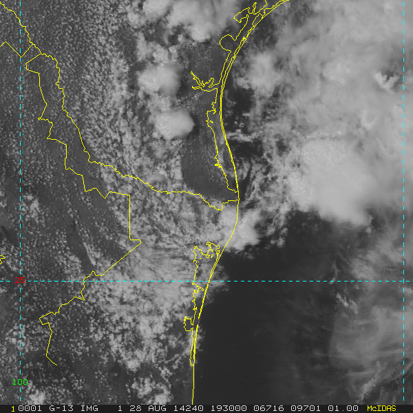
The 'center' moved inland near Port Mansfield at 1930Z.


0 likes
Carla/Alicia/Jerry(In The Eye)/Michelle/Charley/Ivan/Dennis/Katrina/Rita/Wilma/Ike/Harvey
Member: National Weather Association
Wx Infinity Forums
http://wxinfinity.com/index.php
Facebook.com/WeatherInfinity
Twitter @WeatherInfinity
Member: National Weather Association
Wx Infinity Forums
http://wxinfinity.com/index.php
Facebook.com/WeatherInfinity
Twitter @WeatherInfinity
Re: ATL: INVEST 98L - Discussion
They took the Floater off too soon. This is hugging the coast and doesn't want to quit.
0 likes
Low center looks like it's inland over south Texas; how possible is it that this energy that's just sitting there can spin up another low center?
0 likes
The above post is not official and should not be used as such. It is the opinion of the poster and may or may not be backed by sound meteorological data. It is not endorsed by any professional institution or storm2k.org. For official information, please refer to the NHC and NWS products.
Re: ATL: INVEST 98L - Discussion
Look at the way it flared up that wave.
Radar makes it look like the center is trying to reform over the barrier island.
Don't forget there's a front coming that might shove it back in to the Gulf.
Radar makes it look like the center is trying to reform over the barrier island.
Don't forget there's a front coming that might shove it back in to the Gulf.
0 likes
- Miami Storm Tracker
- Category 4

- Posts: 916
- Age: 68
- Joined: Sun Jun 13, 2010 10:12 pm
- Location: Key Largo, Fla.
- Contact:
Re: ATL: INVEST 98L - Discussion
I know this is the wrong page to post this, but is the area south of the DR listed as an invest, I see no area to discuss it?
0 likes
Who is online
Users browsing this forum: No registered users and 16 guests


