ATL: DOLLY - REMNANTS - Discussion

Moderator: S2k Moderators

Message
Author
User avatar
gatorcane
S2K Supporter
S2K Supporter
Posts: 23691
Age: 47
Joined: Sun Mar 13, 2005 3:54 pm
Location: Boca Raton, FL

Re:

#181 Postby gatorcane » Fri Aug 29, 2014 5:41 pm

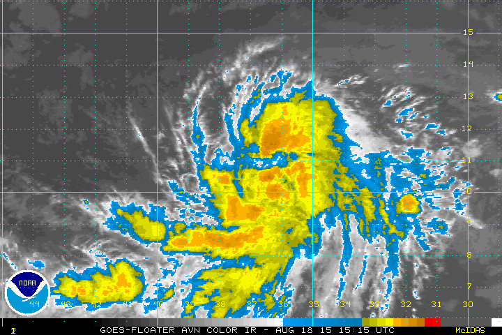
alienstorm wrote:It definitely looks like 2 systems trying to develop these gyro's sometimes generated cyclogensis on the SW and NE portions of the troughs.


Yeah I see what you mean. It looks like we have another large monsoon-like gyre stretched ENE from the SW Carib to Hispaniola. There is still a spin evident in the area south of Hispaniola and that are seems to be drifting NW.

Also the area to the west is looking very juicy with convection this evening and that is moving west.
0 likes   

User avatar
Nimbus
Category 5
Category 5
Posts: 5300
Joined: Mon Jul 19, 2004 10:54 am

#182 Postby Nimbus » Fri Aug 29, 2014 5:48 pm

There is an upper level low up near 25N 68W which has been shearing from the west.
Looks like it is weakening so maybe tomorrow.
0 likes   

User avatar
tropicwatch
Category 5
Category 5
Posts: 3383
Age: 61
Joined: Sat Jun 02, 2007 10:01 am
Location: Panama City Florida
Contact:

Re: Ex INVEST 97L -Tropical Wave in WestCentral Caribbean

#183 Postby tropicwatch » Fri Aug 29, 2014 6:12 pm

Just a little comparison.

97 three days agao
Image

97 now
Image
0 likes   
Tropicwatch


Agnes 72', Eloise 75, Elena 85', Kate 85', Charley 86', Florence 88', Beryl 94', Dean 95', Erin 95', Opal 95', Earl 98', Georges 98', Ivan 2004', Arlene 2005', Dennis 2005', Ida 2009' Debby 2012' Irma 2017' Michael 2018'

User avatar
cycloneye
Admin
Admin
Posts: 145299
Age: 68
Joined: Thu Oct 10, 2002 10:54 am
Location: San Juan, Puerto Rico

Re: Ex INVEST 97L -Tropical Wave in WestCentral Caribbean

#184 Postby cycloneye » Fri Aug 29, 2014 6:23 pm

TROPICAL WEATHER OUTLOOK
NWS NATIONAL HURRICANE CENTER MIAMI FL
800 PM EDT FRI AUG 29 2014

For the North Atlantic...Caribbean Sea and the Gulf of Mexico:

A large area of disorganized cloudiness and thunderstorms is
associated with a tropical wave located in the central Caribbean
Sea. Upper-level winds are forecast to become a little more
favorable for development on Saturday while the wave moves into the
northwestern Caribbean Sea. However, land interaction will likely
limit significant development as the disturbance moves across the
Yucatan peninsula on Sunday. Environmental conditions are expected
to be conducive for some gradual development once the system moves
into the southwestern Gulf of Mexico by Monday.
* Formation chance through 48 hours...low...10 percent.
* Formation chance through 5 days...medium...30 percent.

$$
Forecaster Brennan
0 likes   
Visit the Caribbean-Central America Weather Thread where you can find at first post web cams,radars
and observations from Caribbean basin members Click Here

User avatar
cycloneye
Admin
Admin
Posts: 145299
Age: 68
Joined: Thu Oct 10, 2002 10:54 am
Location: San Juan, Puerto Rico

Re: ATL: INVEST 99L - Discussion

#185 Postby cycloneye » Fri Aug 29, 2014 7:44 pm

Here is the transition point from 97L to 99L for same system.

AL, 99, 2014082900, , BEST, 0, 144N, 770W, 20, 1009, DB, 0, , 0, 0, 0, 0,
AL, 99, 2014082906, , BEST, 0, 145N, 780W, 20, 1009, DB, 0, , 0, 0, 0, 0,
AL, 99, 2014082912, , BEST, 0, 147N, 790W, 20, 1009, DB, 0, , 0, 0, 0, 0,
AL, 99, 2014082918, , BEST, 0, 149N, 800W, 20, 1009, DB, 0, , 0, 0, 0, 0,
AL, 99, 2014083000, , BEST, 0, 151N, 809W, 20, 1009, DB, 34, NEQ, 0, 0, 0, 0, 1010, 150, 40, 0, 0, L, 0,


Post away
0 likes   
Visit the Caribbean-Central America Weather Thread where you can find at first post web cams,radars
and observations from Caribbean basin members Click Here

User avatar
tropicwatch
Category 5
Category 5
Posts: 3383
Age: 61
Joined: Sat Jun 02, 2007 10:01 am
Location: Panama City Florida
Contact:

#186 Postby tropicwatch » Fri Aug 29, 2014 7:51 pm

Its about time, I hate talking about an EX :D
0 likes   
Tropicwatch


Agnes 72', Eloise 75, Elena 85', Kate 85', Charley 86', Florence 88', Beryl 94', Dean 95', Erin 95', Opal 95', Earl 98', Georges 98', Ivan 2004', Arlene 2005', Dennis 2005', Ida 2009' Debby 2012' Irma 2017' Michael 2018'

User avatar
jaguarjace
Category 4
Category 4
Posts: 975
Age: 30
Joined: Sat Jun 11, 2011 7:38 am
Location: Khon Kaen, Thailand

Re: ATL: INVEST 99L - Discussion (Former 97L)

#187 Postby jaguarjace » Fri Aug 29, 2014 7:52 pm

99L INVEST 140830 0000 15.1N 80.9W ATL 20 1009
Image
0 likes   
Owner of the Tropical Archive YouTube channel
Web Developer at Force Thirteen
Twitter/X : @force13_support

User avatar
cycloneye
Admin
Admin
Posts: 145299
Age: 68
Joined: Thu Oct 10, 2002 10:54 am
Location: San Juan, Puerto Rico

Re: ATL: INVEST 99L - Discussion

#188 Postby cycloneye » Fri Aug 29, 2014 8:47 pm

0 likes   
Visit the Caribbean-Central America Weather Thread where you can find at first post web cams,radars
and observations from Caribbean basin members Click Here

HurricaneTracker2031
Tropical Storm
Tropical Storm
Posts: 248
Age: 25
Joined: Fri Jul 19, 2013 7:20 pm
Location: Pembroke Pines, FL, USA
Contact:

Re: ATL: INVEST 99L - Discussion

#189 Postby HurricaneTracker2031 » Fri Aug 29, 2014 9:43 pm

Interesting situation with 99L. It appears that the general consensus is that the system will move into the Gulf of Mexico. Nevertheless, it is too early to know for sure...

Synopsis on the Atlantic and others: http://www.spreaker.com:80/episode/4907783

Personal Forecast Disclaimer:
The posts in this forum are NOT official forecast and should not be used as such. They are just the opinion of the poster and may or may not be backed by sound meteorological data. They are NOT endorsed by any professional institution or storm2k.org. For official information, please refer to the NHC and NWS products.
0 likes   
SHORT VERSION OF DISCLAIMER: THIS SITE LINK BELOW IS NOT AN OFFICIAL FORECASTING OFFICE AND SHOULD NOT BE USED TO MAKE ANY EMERGENCY DECISIONS....

http://www.macstropicalweather.weebly.com

User avatar
cycloneye
Admin
Admin
Posts: 145299
Age: 68
Joined: Thu Oct 10, 2002 10:54 am
Location: San Juan, Puerto Rico

Re: ATL: INVEST 99L - Discussion

#190 Postby cycloneye » Fri Aug 29, 2014 10:13 pm

Not very organized yet.

Image
0 likes   
Visit the Caribbean-Central America Weather Thread where you can find at first post web cams,radars
and observations from Caribbean basin members Click Here

Sanibel
Category 5
Category 5
Posts: 10375
Joined: Mon Aug 30, 2004 11:06 pm
Location: Offshore SW Florida

Re: ATL: INVEST 99L - Discussion

#191 Postby Sanibel » Fri Aug 29, 2014 10:23 pm

This is a strange season. In an area where we have seen well formed cyclones churning through the Caribbean in recent years all we have are struggling disturbances with ill defined organization that is slow to come together.
0 likes   

User avatar
tropicwatch
Category 5
Category 5
Posts: 3383
Age: 61
Joined: Sat Jun 02, 2007 10:01 am
Location: Panama City Florida
Contact:

Re: ATL: INVEST 99L - Discussion

#192 Postby tropicwatch » Sat Aug 30, 2014 4:59 am

Hard to tell but in the last few images it appears that a circulation might be taking shape in the general vicinity of 17.5n 83.5W.

Image
0 likes   
Tropicwatch


Agnes 72', Eloise 75, Elena 85', Kate 85', Charley 86', Florence 88', Beryl 94', Dean 95', Erin 95', Opal 95', Earl 98', Georges 98', Ivan 2004', Arlene 2005', Dennis 2005', Ida 2009' Debby 2012' Irma 2017' Michael 2018'

User avatar
cycloneye
Admin
Admin
Posts: 145299
Age: 68
Joined: Thu Oct 10, 2002 10:54 am
Location: San Juan, Puerto Rico

Re: ATL: INVEST 99L - Discussion

#193 Postby cycloneye » Sat Aug 30, 2014 6:42 am

TROPICAL WEATHER OUTLOOK
NWS NATIONAL HURRICANE CENTER MIAMI FL
800 AM EDT SAT AUG 30 2014

For the North Atlantic...Caribbean Sea and the Gulf of Mexico:

Disorganized shower and thunderstorm activity continues in
association with a tropical wave over the western Caribbean Sea.
Upper-level winds are expected to become more conducive during the
next couple of days, but land interaction will likely limit
significant development while the disturbance moves across the
Yucatan peninsula Sunday and Sunday night. Environmental conditions
are expected to be conducive for some gradual development once the
system moves into the southwestern Gulf of Mexico by Monday.
* Formation chance through 48 hours...low...10 percent.
* Formation chance through 5 days...medium...40 percent.

$$
Forecaster Beven
0 likes   
Visit the Caribbean-Central America Weather Thread where you can find at first post web cams,radars
and observations from Caribbean basin members Click Here

User avatar
cycloneye
Admin
Admin
Posts: 145299
Age: 68
Joined: Thu Oct 10, 2002 10:54 am
Location: San Juan, Puerto Rico

Re: ATL: INVEST 99L - Discussion

#194 Postby cycloneye » Sat Aug 30, 2014 8:01 am

12z Best Track.

99L INVEST 140830 1200 16.6N 84.6W ATL 25 1009
0 likes   
Visit the Caribbean-Central America Weather Thread where you can find at first post web cams,radars
and observations from Caribbean basin members Click Here

User avatar
cycloneye
Admin
Admin
Posts: 145299
Age: 68
Joined: Thu Oct 10, 2002 10:54 am
Location: San Juan, Puerto Rico

Re: ATL: INVEST 99L - Discussion

#195 Postby cycloneye » Sat Aug 30, 2014 8:23 am

Nothing impressive so far at the Belize radar.Saved loop.

Image

http://www.hydromet.gov.bz/
0 likes   
Visit the Caribbean-Central America Weather Thread where you can find at first post web cams,radars
and observations from Caribbean basin members Click Here

User avatar
wxman57
Moderator-Pro Met
Moderator-Pro Met
Posts: 22978
Age: 67
Joined: Sat Jun 21, 2003 8:06 pm
Location: Houston, TX (southwest)

Re: ATL: INVEST 99L - Discussion

#196 Postby wxman57 » Sat Aug 30, 2014 8:34 am

Would anyone like to guess when was the last time that there was not even a depression in the Gulf prior to September 1st? I'll give you a hint - I was just starting 1st grade.
0 likes   

User avatar
Kludge
S2K Supporter
S2K Supporter
Posts: 215
Joined: Thu Aug 26, 2004 9:03 pm
Location: Montgomery, Texas

Re: ATL: INVEST 99L - Discussion

#197 Postby Kludge » Sat Aug 30, 2014 8:58 am

wxman57 wrote:Would anyone like to guess when was the last time that there was not even a depression in the Gulf prior to September 1st? I'll give you a hint - I was just starting 1st grade.


1650...????! Really? That long? :D :wink:

jk... you teed that one up for us.
0 likes   

User avatar
cycloneye
Admin
Admin
Posts: 145299
Age: 68
Joined: Thu Oct 10, 2002 10:54 am
Location: San Juan, Puerto Rico

Re: ATL: INVEST 99L - Discussion

#198 Postby cycloneye » Sat Aug 30, 2014 9:31 am

Possible recon for Monday afternoon in BOC.

WEATHER RECONNAISSANCE FLIGHTS
CARCAH, NATIONAL HURRICANE CENTER, MIAMI, FL.
1000 AM EDT SAT 30 AUGUST 2014
SUBJECT: TROPICAL CYCLONE PLAN OF THE DAY (TCPOD)
VALID 31/1100Z TO 01/1100Z SEPTEMBER 2014
TCPOD NUMBER.....14-091

I. ATLANTIC REQUIREMENTS
1. NEGATIVE RECONNAISSANCE REQUIREMENTS.
2. OUTLOOK FOR SUCCEEDING DAY.....A POSSIBLE LOW LEVEL
INVEST NEAR 20.5N 92.0W AT 01/1730Z
.
0 likes   
Visit the Caribbean-Central America Weather Thread where you can find at first post web cams,radars
and observations from Caribbean basin members Click Here

User avatar
cycloneye
Admin
Admin
Posts: 145299
Age: 68
Joined: Thu Oct 10, 2002 10:54 am
Location: San Juan, Puerto Rico

Re: ATL: INVEST 99L - Discussion

#199 Postby cycloneye » Sat Aug 30, 2014 9:43 am

Saturday morning discussion of 99L by Dr Jeff Masters.

A tropical wave in the Western Caribbean was designated Invest 99L by the National Hurricane Center on Friday night, and is headed west-northwest at about 15 mph. Satellite loops on Saturday morning showed that 99L had a modest amount of spin and heavy thunderstorms, but these thunderstorms were poorly organized. Sea Surface Temperatures (SSTs) were very warm, near 29°C (84°F), and wind shear was moderate, 10 - 20 knots. Although these conditions are favorable for development, 99L will likely not have enough time to develop before crossing Mexico's Yucatan Peninsula on Sunday. The 8 am Saturday run of the SHIPS model predicted that conditions will be even more favorable for development on Monday when the wave will emerge in the Gulf of Mexico's Bay of Campeche. Wind shear will remain moderate, the atmosphere will be moister, and SSTs will be warmer: 29.5°C (85°F.) One of our three reliable computer models for predicting tropical storm formation, the GFS, showed some weak development occurring in the Bay of Campeche on Tuesday. In their 8 am EDT Saturday Tropical Weather Outlook, NHC gave 99L 2-day and 5-day development odds of 10% and 40%, respectively. The semi-circular ring of high terrain along the southern edge of the Bay of Campeche is known to aid in generating the counter-clockwise spiraling winds needed to assist in spinning up a new tropical storm, and given the propensity of tropical storms to quickly spin up in the Bay of Campeche, I'd put the 5-day development odds at 50%. If a tropical storm does form in the Bay of Campeche, the most likely track would be to the west-northwest or northwest towards the Mexican coast south of Texas. An Air Force hurricane hunter aircraft has been tasked to investigate 99L on Monday afternoon, if necessary.
0 likes   
Visit the Caribbean-Central America Weather Thread where you can find at first post web cams,radars
and observations from Caribbean basin members Click Here

redneckweather
Tropical Wave
Tropical Wave
Posts: 5
Joined: Tue Jan 04, 2011 1:43 pm

Re: ATL: INVEST 99L - Discussion

#200 Postby redneckweather » Sat Aug 30, 2014 10:15 am

wxman57 wrote:Would anyone like to guess when was the last time that there was not even a depression in the Gulf prior to September 1st? I'll give you a hint - I was just starting 1st grade.


1961
0 likes   


Return to “2014”

Who is online

Users browsing this forum: No registered users and 2 guests