ATL: DOLLY - REMNANTS - Discussion

Moderator: S2k Moderators

Message
Author
Javlin
Category 5
Category 5
Posts: 1620
Age: 64
Joined: Fri Jul 09, 2004 7:58 pm
Location: ms gulf coast

Re: ATL: INVEST 99L - Discussion

#221 Postby Javlin » Sat Aug 30, 2014 10:56 pm

wxman57 wrote:
Andrew92 wrote:
wxman57 wrote:Would anyone like to guess when was the last time that there was not even a depression in the Gulf prior to September 1st? I'll give you a hint - I was just starting 1st grade.


1963. Only Gulf storm that year was Cindy which didn't form until September.

-Andrew92


Correct! 52 seasons ago. So far this season, we've had only 2 disturbances in the Gulf. That's a record low, too.


Sounds like a winner to me :wink: the record low.
0 likes   

HurricaneTracker2031
Tropical Storm
Tropical Storm
Posts: 248
Age: 25
Joined: Fri Jul 19, 2013 7:20 pm
Location: Pembroke Pines, FL, USA
Contact:

Re: ATL: INVEST 99L - Discussion

#222 Postby HurricaneTracker2031 » Sat Aug 30, 2014 11:45 pm

My analysis of Invest 99L
Issued 12:38AM August 31st 2014

Personal Forecast Disclaimer:
The posts in this forum are NOT official forecast and should not be used as such. They are just the opinion of the poster and may or may not be backed by sound meteorological data. They are NOT endorsed by any professional institution or storm2k.org. For official information, please refer to the NHC and NWS products.


Invest 99L, is a tropical disturbance that is just East of Belize and is looking disorganized at this time. Significant development of this system, if any, may occur as it move West-Northwestward into the Gulf of Mexico nearing Mexico and possibly Texas. Regardless of development, this system may provide some precipitation for Mexico and/or Texas over the couple of days. Therefore, I am giving this system a low chance (20%) of becoming a tropical cyclone within the next 48 hours and a medium chance (40%) of becoming a tropical cyclone within the next 5 days.

Listen to the full broadcasts for this and other basins: http://goo.gl/Hprb6Y

Personal Forecast Disclaimer:
The posts in this forum are NOT official forecast and should not be used as such. They are just the opinion of the poster and may or may not be backed by sound meteorological data. They are NOT endorsed by any professional institution or storm2k.org. For official information, please refer to the NHC and NWS products.
0 likes   
SHORT VERSION OF DISCLAIMER: THIS SITE LINK BELOW IS NOT AN OFFICIAL FORECASTING OFFICE AND SHOULD NOT BE USED TO MAKE ANY EMERGENCY DECISIONS....

http://www.macstropicalweather.weebly.com

bamajammer4eva
Category 4
Category 4
Posts: 907
Joined: Sun Apr 18, 2010 3:21 am
Location: Ozark, AL

#223 Postby bamajammer4eva » Sun Aug 31, 2014 1:14 am

TROPICAL WEATHER OUTLOOK
NWS NATIONAL HURRICANE CENTER MIAMI FL
200 AM EDT SUN AUG 31 2014

For the North Atlantic...Caribbean Sea and the Gulf of Mexico:

1. Disorganized shower and thunderstorm activity continues in
association with a tropical wave over the northwestern Caribbean
Sea. Land interaction will limit significant development while the
disturbance moves across the Yucatan peninsula today and tonight.
However, environmental conditions are expected to be become
marginally conducive for some gradual development once the system
moves into the southwestern Gulf of Mexico on Monday.
* Formation chance through 48 hours...low...20 percent.
* Formation chance through 5 days...medium...50 percent.

Forecaster Stewart
0 likes   

User avatar
cycloneye
Admin
Admin
Posts: 145303
Age: 68
Joined: Thu Oct 10, 2002 10:54 am
Location: San Juan, Puerto Rico

Re: ATL: INVEST 99L - Discussion

#224 Postby cycloneye » Sun Aug 31, 2014 6:35 am

TROPICAL WEATHER OUTLOOK
NWS NATIONAL HURRICANE CENTER MIAMI FL
800 AM EDT SUN AUG 31 2014

For the North Atlantic...Caribbean Sea and the Gulf of Mexico:

Disorganized shower and thunderstorm activity continues in
association with a tropical wave over the northwestern Caribbean
Sea. Land interaction will limit significant development while the
disturbance moves across the Yucatan peninsula today and tonight.
However, environmental conditions are expected to be conducive for
development once the system moves into the southwestern Gulf of
Mexico on Monday.
* Formation chance through 48 hours...medium...30 percent.
* Formation chance through 5 days...medium...50 percent.

$$
Forecaster Pasch
0 likes   
Visit the Caribbean-Central America Weather Thread where you can find at first post web cams,radars
and observations from Caribbean basin members Click Here

User avatar
NDG
S2K Supporter
S2K Supporter
Posts: 15446
Joined: Sun Jul 09, 2006 10:14 pm
Location: Orlando, FL

Re: ATL: INVEST 99L - Discussion

#225 Postby NDG » Sun Aug 31, 2014 6:44 am

If development was imminent in the southern GOM you would think chances by the NHC would had been set on High by now in the 5 day range since it will be pushing inland into the mainland of MX in 3-4 days.
0 likes   

User avatar
tailgater
S2K Supporter
S2K Supporter
Posts: 3339
Joined: Sun Jul 11, 2004 9:13 pm
Location: St. Amant La.

Re: ATL: INVEST 99L - Discussion

#226 Postby tailgater » Sun Aug 31, 2014 8:59 am

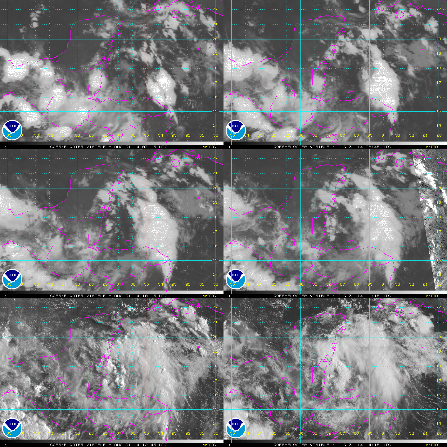
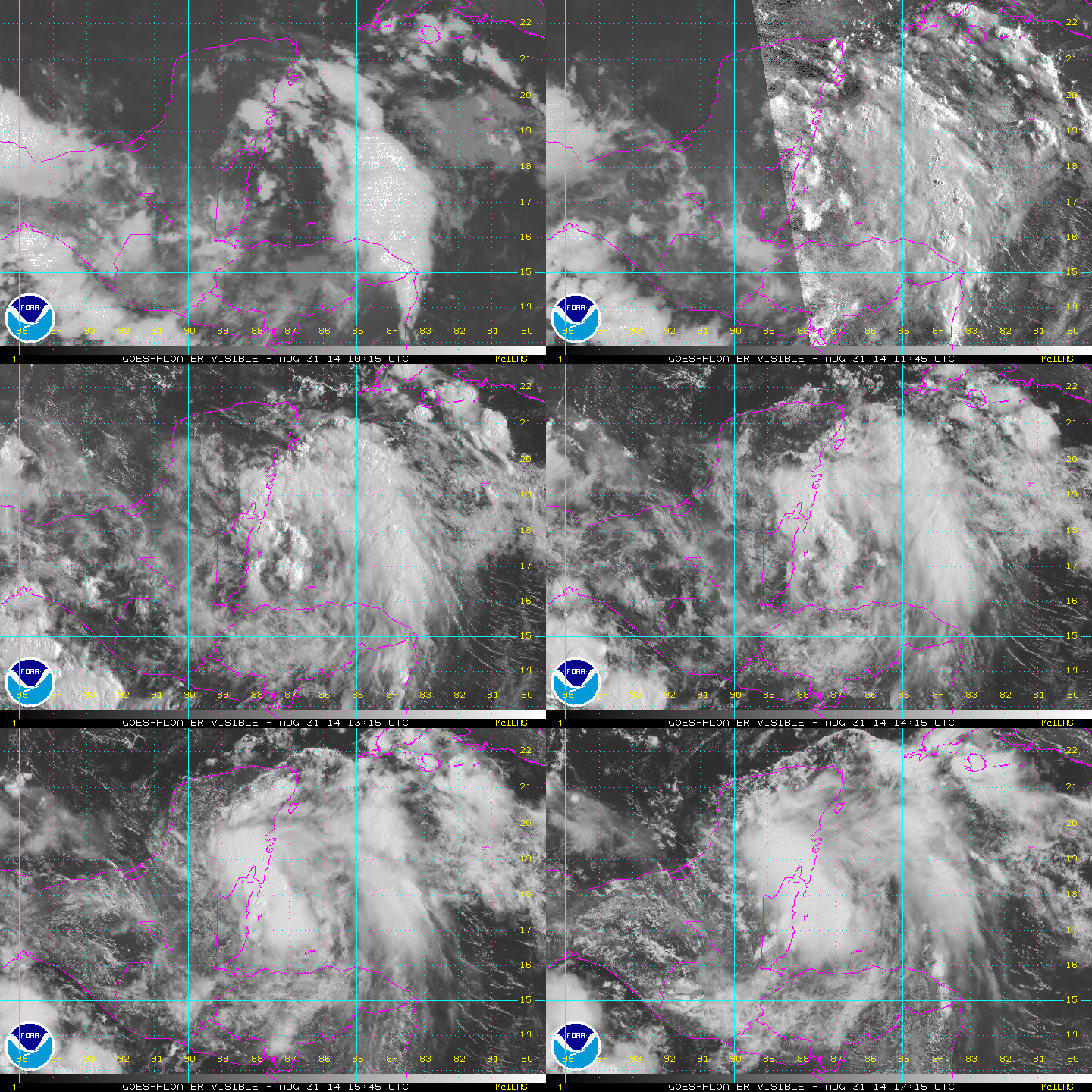
starting to get it's act together now,
Image
radar loop

Image
0 likes   
The following post is NOT an official forecast and should not be used as such. It is just the opinion of the poster and may or may not be backed by sound meteorological data. It is NOT endorsed by any professional institution including storm2k.org For Official Information please refer to the NHC and NWS products.

User avatar
Rgv20
S2K Supporter
S2K Supporter
Posts: 2466
Age: 38
Joined: Wed Jan 05, 2011 5:42 pm
Location: Edinburg/McAllen Tx

#227 Postby Rgv20 » Sun Aug 31, 2014 10:04 am

99L definitely looking good this morning..

Saved Loop:
Image
0 likes   
The following post is NOT an official forecast and should not be used as such. It is just the opinion of the poster and may or may not be backed by sound meteorological data. It is NOT endorsed by any professional institution including storm2k.org For Official Information please refer to the NHC and NWS products.

User avatar
cycloneye
Admin
Admin
Posts: 145303
Age: 68
Joined: Thu Oct 10, 2002 10:54 am
Location: San Juan, Puerto Rico

Re: ATL: INVEST 99L - Discussion

#228 Postby cycloneye » Sun Aug 31, 2014 10:52 am

It will be important for 99L if is going to develop how north in latitude it emerges into the BOC but is looking good.
0 likes   
Visit the Caribbean-Central America Weather Thread where you can find at first post web cams,radars
and observations from Caribbean basin members Click Here

User avatar
tropicwatch
Category 5
Category 5
Posts: 3383
Age: 61
Joined: Sat Jun 02, 2007 10:01 am
Location: Panama City Florida
Contact:

#229 Postby tropicwatch » Sun Aug 31, 2014 11:02 am

Currently the area around Belmopan Belize are reporting the lowest pressures.
0 likes   
Tropicwatch


Agnes 72', Eloise 75, Elena 85', Kate 85', Charley 86', Florence 88', Beryl 94', Dean 95', Erin 95', Opal 95', Earl 98', Georges 98', Ivan 2004', Arlene 2005', Dennis 2005', Ida 2009' Debby 2012' Irma 2017' Michael 2018'

User avatar
cycloneye
Admin
Admin
Posts: 145303
Age: 68
Joined: Thu Oct 10, 2002 10:54 am
Location: San Juan, Puerto Rico

Re: ATL: INVEST 99L - Discussion

#230 Postby cycloneye » Sun Aug 31, 2014 12:34 pm

TROPICAL WEATHER OUTLOOK
NWS NATIONAL HURRICANE CENTER MIAMI FL
200 PM EDT SUN AUG 31 2014

For the North Atlantic...Caribbean Sea and the Gulf of Mexico:

Shower and thunderstorm activity associated with a tropical wave
over the eastern Yucatan Peninsula and Belize has become a little
better organized over the past few hours. However, land interaction
is expected to limit significant development while the disturbance
moves across the Yucatan peninsula later today and tonight.
Environmental conditions are expected to be conducive for
development once the system moves into the southwestern Gulf of
Mexico on Monday.
* Formation chance through 48 hours...medium...40 percent.
* Formation chance through 5 days...high...60 percent.

$$
Forecaster Pasch
0 likes   
Visit the Caribbean-Central America Weather Thread where you can find at first post web cams,radars
and observations from Caribbean basin members Click Here

User avatar
Blown Away
S2K Supporter
S2K Supporter
Posts: 10145
Joined: Wed May 26, 2004 6:17 am

Re: ATL: INVEST 99L - Discussion

#231 Postby Blown Away » Sun Aug 31, 2014 12:56 pm

North Atlantic and Southern BOC has become the new MDR...
Last edited by Blown Away on Sun Aug 31, 2014 12:58 pm, edited 2 times in total.
0 likes   
Hurricane Eye Experience: David 79, Irene 99, Frances 04, Jeanne 04, Wilma 05... EYE COMING MY WAY IN 2024…
Hurricane Brush Experience: Andrew 92, Erin 95, Floyd 99, Matthew 16, Irma 17, Ian 22, Nicole 22…

User avatar
Rgv20
S2K Supporter
S2K Supporter
Posts: 2466
Age: 38
Joined: Wed Jan 05, 2011 5:42 pm
Location: Edinburg/McAllen Tx

#232 Postby Rgv20 » Sun Aug 31, 2014 12:57 pm

Looking really good right now, its going to be interesting it what shape it comes out after interacting with the Yucatan. (history tells us that the Yucatan is gentle towards Tropical Disturbances)

Cycloneye, IMO if 99L can come out of the Yucatan at least on 20N it will be in a very good shape to strengthening come Monday.

Saved Loop:
Image
0 likes   
The following post is NOT an official forecast and should not be used as such. It is just the opinion of the poster and may or may not be backed by sound meteorological data. It is NOT endorsed by any professional institution including storm2k.org For Official Information please refer to the NHC and NWS products.

User avatar
srainhoutx
S2K Supporter
S2K Supporter
Posts: 6919
Age: 67
Joined: Sun Jan 14, 2007 11:34 am
Location: Haywood County, NC
Contact:

Re: ATL: INVEST 99L - Discussion

#233 Postby srainhoutx » Sun Aug 31, 2014 1:04 pm

Pressures are beginning to fall SW of Merida and NW of Campeche. That tends to suggest this disturbance is heading WNW with the wave axis across the Central Yucatan Peninsula.
0 likes   
Carla/Alicia/Jerry(In The Eye)/Michelle/Charley/Ivan/Dennis/Katrina/Rita/Wilma/Ike/Harvey

Member: National Weather Association
Wx Infinity Forums
http://wxinfinity.com/index.php

Facebook.com/WeatherInfinity
Twitter @WeatherInfinity

User avatar
SFLcane
S2K Supporter
S2K Supporter
Posts: 10163
Age: 47
Joined: Sat Jun 05, 2010 1:44 pm
Location: Lake Worth Florida

Re: ATL: INVEST 99L - Discussion

#234 Postby SFLcane » Sun Aug 31, 2014 1:36 pm

Blown Away wrote:North Atlantic and Southern BOC has become the new MDR...


sadly but true this season. jokes aside plenty of rainfall down there for those folks from what could be dolly.
0 likes   

User avatar
cycloneye
Admin
Admin
Posts: 145303
Age: 68
Joined: Thu Oct 10, 2002 10:54 am
Location: San Juan, Puerto Rico

Re: ATL: INVEST 99L - Discussion

#235 Postby cycloneye » Sun Aug 31, 2014 1:38 pm

18z Best Track.

AL, 99, 2014083118, , BEST, 0, 183N, 888W, 25, 1009, DB
0 likes   
Visit the Caribbean-Central America Weather Thread where you can find at first post web cams,radars
and observations from Caribbean basin members Click Here

User avatar
TropicalAnalystwx13
Category 5
Category 5
Posts: 2109
Age: 27
Joined: Tue Jul 19, 2011 8:20 pm
Location: Wilmington, NC
Contact:

#236 Postby TropicalAnalystwx13 » Sun Aug 31, 2014 1:44 pm

A low-level circulation looks to be taking shape over the Yucatan, which isn't all that surprising with disturbances in this area. My forecast still favors a moderate-strength Tropical Storm Dolly (50-60 mph) moving ashore near Tampico, Mexico by the middle of the week given very warm ocean temperatures, sufficient mid-level moisture, and moderate wind shear.
0 likes   

User avatar
Hammy
Category 5
Category 5
Posts: 5849
Age: 41
Joined: Fri May 25, 2012 5:25 pm
Contact:

Re:

#237 Postby Hammy » Sun Aug 31, 2014 2:28 pm

TropicalAnalystwx13 wrote:A low-level circulation looks to be taking shape over the Yucatan, which isn't all that surprising with disturbances in this area.


I remember this happening with Barry last year as well, do the mountains to the south help the airflow circle around better?
0 likes   
The above post is not official and should not be used as such. It is the opinion of the poster and may or may not be backed by sound meteorological data. It is not endorsed by any professional institution or storm2k.org. For official information, please refer to the NHC and NWS products.

User avatar
Nimbus
Category 5
Category 5
Posts: 5300
Joined: Mon Jul 19, 2004 10:54 am

Re: Re:

#238 Postby Nimbus » Sun Aug 31, 2014 2:51 pm

Hammy wrote:
TropicalAnalystwx13 wrote:A low-level circulation looks to be taking shape over the Yucatan, which isn't all that surprising with disturbances in this area.


I remember this happening with Barry last year as well, do the mountains to the south help the airflow circle around better?


There have been a lot of tropical disturbances that go inland over the Yucatan and develop circulations as they enter the Bay of Campeche.
Some of that probably occurs due to the shape of the coastline as they make landfall.
There is also the last minute High SSTs just offshore.

A WNW track would be the shortest route to the BOC and the initial convective burst once it emerges will help focus the center of surface low pressure.
0 likes   

User avatar
TexasF6
S2K Supporter
S2K Supporter
Posts: 816
Joined: Mon Aug 09, 2004 9:33 pm
Location: Austin, TX

Re: ATL: INVEST 99L - Discussion

#239 Postby TexasF6 » Sun Aug 31, 2014 2:58 pm

Notice the mid-level circulation to the NE of the center crashing into Belize? A center relocation puts Texas into play, IMO. We need the rain for sure, minus the destruction. :roll:


Personal Forecast Disclaimer:
The posts in this forum are NOT official forecast and should not be used as such. They are just the opinion of the poster and may or may not be backed by sound meteorological data. They are NOT endorsed by any professional institution or storm2k.org. For official information, please refer to the NHC and NWS products.
0 likes   

YoshiMike
Tropical Storm
Tropical Storm
Posts: 106
Age: 29
Joined: Wed Aug 27, 2014 9:18 pm
Location: Hattiesburg, MS
Contact:

#240 Postby YoshiMike » Sun Aug 31, 2014 3:07 pm

:eek: i honestly didnt think that this thing was going to make it at all actually
0 likes   
Okay guys, just because I want to BE a meteorologist, want to go to school for meteorology, DOES NOT MAKE ME A METEOROLOGIST. Anything I say about tropical weather is either me learning something new, or is just an opinion and nothing more than that. I can almost guarantee you that I will be wrong about pretty much everything.


Return to “2014”

Who is online

Users browsing this forum: No registered users and 2 guests