This has been a very interesting feature, which I have followed all week. This elongated vorticity began drifting north yesterday out of the Straits. Now it does seem that there is something trying to develop at the surface. Observing both Jax and Melbourne radar, there appears to be a very broad circulation over East Central Florida peninsula at this time. This is all part of the overall elongated axis which we discussed yesterday and as shifted north over the peninsula the past 24 hours or so.
This feature needs to be watched carefully. Much will depend on if it moves off the coast into the Gulf Stream this weekend. Right now the overall system is moving N/N-NW, with much of the axis over the peninsula.
It looks as if this wants to merge with a front coming down to the Eastern seabord in a couple of days.
Area of Disturbed Weather Near the NE Florida/Georgia coast
Moderator: S2k Moderators
Forum rules

The posts in this forum are NOT official forecasts and should not be used as such. They are just the opinion of the poster and may or may not be backed by sound meteorological data. They are NOT endorsed by any professional institution or STORM2K. For official information, please refer to products from the National Hurricane Center and National Weather Service.
-
northjaxpro

- S2K Supporter

- Posts: 8900
- Joined: Mon Sep 27, 2010 11:21 am
- Location: Jacksonville, FL
Last edited by northjaxpro on Thu Sep 04, 2014 10:16 pm, edited 1 time in total.
0 likes
NEVER, EVER SAY NEVER in the tropics and weather in general, and most importantly, with life itself!!
________________________________________________________________________________________
Fay 2008 Beryl 2012 Debby 2012 Colin 2016 Hermine 2016 Julia 2016 Matthew 2016 Irma 2017 Dorian 2019
________________________________________________________________________________________
Fay 2008 Beryl 2012 Debby 2012 Colin 2016 Hermine 2016 Julia 2016 Matthew 2016 Irma 2017 Dorian 2019

-
northjaxpro
- S2K Supporter
- Posts: 8900
- Joined: Mon Sep 27, 2010 11:21 am
- Location: Jacksonville, FL
Re: Area of Disturbed Weather Near Florida
Looking at Jax radar, it appears that a small, meso-Low circulation is approaching the SE Georgia coastline, with the old elongated axis still drifting north across North and East Central Florida and the adjacent Atlantic waters.
0 likes
NEVER, EVER SAY NEVER in the tropics and weather in general, and most importantly, with life itself!!
________________________________________________________________________________________
Fay 2008 Beryl 2012 Debby 2012 Colin 2016 Hermine 2016 Julia 2016 Matthew 2016 Irma 2017 Dorian 2019
________________________________________________________________________________________
Fay 2008 Beryl 2012 Debby 2012 Colin 2016 Hermine 2016 Julia 2016 Matthew 2016 Irma 2017 Dorian 2019
-
northjaxpro
- S2K Supporter
- Posts: 8900
- Joined: Mon Sep 27, 2010 11:21 am
- Location: Jacksonville, FL
There is a small, albeit weak meso-Low right along the SE Georgia coast near Darien early this morning, while the old TUTT axis continues to drift north over the Northern Florida peninsula and the adjacent Atlantic waters. This will bring enhanced rain chances to our area the next couple of days.
The meso-Low over coastal Georgia will meander for a couple of days in weak steering flow until around Sunday as a frontal system is expected to pick up this small Low and move it to the northeast, where it may merge with the front near the SC/NC coast. Watch this meso-Low feature carefully the next couple of days for any potential tropical cyclone development as it will meander around coastal GA/SC.
Also, along with the meso-Low feature along coastal GA, I also noticed that another possible meso feature may be showing on Jax radar out over the Gulf Stream about 70-80 miles east of Daytona Beach along that old elongated axis referenced earlier. There is currently a pretty decent convection burst occuring out there at this hour.
0 likes
NEVER, EVER SAY NEVER in the tropics and weather in general, and most importantly, with life itself!!
________________________________________________________________________________________
Fay 2008 Beryl 2012 Debby 2012 Colin 2016 Hermine 2016 Julia 2016 Matthew 2016 Irma 2017 Dorian 2019
________________________________________________________________________________________
Fay 2008 Beryl 2012 Debby 2012 Colin 2016 Hermine 2016 Julia 2016 Matthew 2016 Irma 2017 Dorian 2019
-
tropicwatch

- Category 5

- Posts: 3426
- Age: 62
- Joined: Sat Jun 02, 2007 10:01 am
- Location: Panama City Florida
- Contact:
Re: Area of Disturbed Weather Near the NE Florida/Georgia coast
850mb vorticity is increasing just off of Jacksonville.

0 likes
Tropicwatch
Agnes 72', Eloise 75, Elena 85', Kate 85', Charley 86', Florence 88', Beryl 94', Dean 95', Erin 95', Opal 95', Earl 98', Georges 98', Ivan 2004', Arlene 2005', Dennis 2005', Ida 2009' Debby 2012' Irma 2017' Michael 2018'
Agnes 72', Eloise 75, Elena 85', Kate 85', Charley 86', Florence 88', Beryl 94', Dean 95', Erin 95', Opal 95', Earl 98', Georges 98', Ivan 2004', Arlene 2005', Dennis 2005', Ida 2009' Debby 2012' Irma 2017' Michael 2018'
-
tolakram
- Admin

- Posts: 20168
- Age: 62
- Joined: Sun Aug 27, 2006 8:23 pm
- Location: Florence, KY (name is Mark)
Re: Area of Disturbed Weather Near the NE Florida/Georgia coast
0 likes
M a r k
- - - - -
Join us in chat: Storm2K Chatroom Invite. Android and IOS apps also available.
The posts in this forum are NOT official forecasts and should not be used as such. Posts are NOT endorsed by any professional institution or STORM2K.org. For official information and forecasts, please refer to NHC and NWS products.
Re: Area of Disturbed Weather Near the NE Florida/Georgia coast
Beleive it or not, I have a feeling tht they may tag the area ENE of Jax an invest later today. If the NE shear lessens, this may have a chance to develop.
The posts in this forum are NOT official forecast and should not be used as such. They are just the opinion of the poster and may or may not be backed by sound meteorological data. They are NOT endorsed by any professional institution or storm2k.org. For official information, please refer to the NHC and NWS products.
The posts in this forum are NOT official forecast and should not be used as such. They are just the opinion of the poster and may or may not be backed by sound meteorological data. They are NOT endorsed by any professional institution or storm2k.org. For official information, please refer to the NHC and NWS products.
0 likes
-
northjaxpro
- S2K Supporter
- Posts: 8900
- Joined: Mon Sep 27, 2010 11:21 am
- Location: Jacksonville, FL
EURO has been showing a possible development of a Low Pressure by Sunday just off the SC coast. I think the chance is there for development as shear values are beginning to ease in this area to allow a window for possible development. However, as I discussed earlier in this thread, if a Low develops, it may merge with an approaching front which will reach the SE Atlantic coast by Monday.
0 likes
NEVER, EVER SAY NEVER in the tropics and weather in general, and most importantly, with life itself!!
________________________________________________________________________________________
Fay 2008 Beryl 2012 Debby 2012 Colin 2016 Hermine 2016 Julia 2016 Matthew 2016 Irma 2017 Dorian 2019
________________________________________________________________________________________
Fay 2008 Beryl 2012 Debby 2012 Colin 2016 Hermine 2016 Julia 2016 Matthew 2016 Irma 2017 Dorian 2019

Re: Area of Disturbed Weather Near the NE Florida/Georgia coast
Check out the west coast Tampa radar there is a weak circulation over the gulf.
http://radblast-aa.wunderground.com/cgi ... ightning=0
http://radblast-aa.wunderground.com/cgi ... ightning=0
0 likes
-
northjaxpro
- S2K Supporter
- Posts: 8900
- Joined: Mon Sep 27, 2010 11:21 am
- Location: Jacksonville, FL
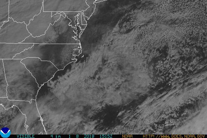
Visible satellite imagery, along with Jax and Charleston, SC radars clearly shows a very broad mid level circulation just off the Georgia coast east of Saint Simons Island. Also, within the broad circulation, there is also a weak meso-vort feature rotating south over the Okefenokee Swamp. The overall motion was a slow drift north-northwest throughout the day, but over the past couple of hours, it has meandered about, and that is expected over the next 36 hours or so as the steering flow is weak right now in this area.
This axis remains elongated, so if any development occurs, it will take some time, although the system is definitely trying its best to attain a surface reflection. If convection can burst tonight, similar to what occured earlier thismorning in the pre-dawn hours, then I think we may have a very unique feature this weekend. If the small chance of seeing something develop, it looks as if this feature not only will get picked up by an approaching mid/upper trough and accompanying front to move into the SE Atlantic coast region by Monday, but the potential Low may merge with the front as well. Will continue to monitor.
[img] http://www.goes.noaa.gov/GIFS/ECSTVS.JPG[/img]
0 likes
NEVER, EVER SAY NEVER in the tropics and weather in general, and most importantly, with life itself!!
________________________________________________________________________________________
Fay 2008 Beryl 2012 Debby 2012 Colin 2016 Hermine 2016 Julia 2016 Matthew 2016 Irma 2017 Dorian 2019
________________________________________________________________________________________
Fay 2008 Beryl 2012 Debby 2012 Colin 2016 Hermine 2016 Julia 2016 Matthew 2016 Irma 2017 Dorian 2019
-
northjaxpro
- S2K Supporter
- Posts: 8900
- Joined: Mon Sep 27, 2010 11:21 am
- Location: Jacksonville, FL
Charleston NWS WFO had an interseting AFD regarding the feature off the GA coast, with a mention should the front slow down down and our feature develops, it may become a subtropical hybrid:
excerpt
Short term /6 am Friday morning through Sunday/...
a broad trough off the east Florida coast may slowly become more
organized and form a closed low as it drifts north-northwest Friday into
Saturday. The models are quite uncertain about this feature and its
eventual track and strength. Regardless...it seems quite certain
that deep tropical moisture will continue to stream into the area
from the south and southeast. Precipitable waters are predicted to remain above 2
inches through Sunday. On Friday...the best convergence will be over
the waters in the morning...then with a robust sea breeze we should
see scattered showers and thunderstorms over land in the afternoon.
As the trough/low drifts closer to the area Saturday into Sunday we
expect increasing moisture and convergence to result in better
coverage of showers and thunderstorms. The greatest coverage should remain
over the waters but by Sunday when the cold front drops south and
the low becomes part of the baroclinic zone...plenty of lift should
be present for numerous showers and thunderstorms. Because of the
approaching cold front...NHC/WPC believe the low would probably not
become tropical...though if the front slows down there could be some
sort of sub-tropical hybrid off our coast late in the weekend.
0 likes
NEVER, EVER SAY NEVER in the tropics and weather in general, and most importantly, with life itself!!
________________________________________________________________________________________
Fay 2008 Beryl 2012 Debby 2012 Colin 2016 Hermine 2016 Julia 2016 Matthew 2016 Irma 2017 Dorian 2019
________________________________________________________________________________________
Fay 2008 Beryl 2012 Debby 2012 Colin 2016 Hermine 2016 Julia 2016 Matthew 2016 Irma 2017 Dorian 2019

Re: Area of Disturbed Weather Near the NE Florida/Georgia coast
It seems like the surface trough is now inland while the H85 vorticity is still offshore the GA coast.
0 likes
-
northjaxpro
- S2K Supporter
- Posts: 8900
- Joined: Mon Sep 27, 2010 11:21 am
- Location: Jacksonville, FL
Yeah NDG, the meso-Low feature moved inland earlier this morning during the pre-dawn hours from the GA coast and it is now drifting south/southeast through the Okefenokee Swamp and moving back into Nassau County in NE Florida, rotating down from the broader circulation within the the mid -level vorticity just off shore the Georgia coast.
Speaking of which, we are in for a dumping of rain this evening as I am about to get thunderstorms moving into my area from the meso feature aformentioned and another strong bands of storms moving in from the southwest, which will be in the Jax area within the next couple of hours.

Speaking of which, we are in for a dumping of rain this evening as I am about to get thunderstorms moving into my area from the meso feature aformentioned and another strong bands of storms moving in from the southwest, which will be in the Jax area within the next couple of hours.
0 likes
NEVER, EVER SAY NEVER in the tropics and weather in general, and most importantly, with life itself!!
________________________________________________________________________________________
Fay 2008 Beryl 2012 Debby 2012 Colin 2016 Hermine 2016 Julia 2016 Matthew 2016 Irma 2017 Dorian 2019
________________________________________________________________________________________
Fay 2008 Beryl 2012 Debby 2012 Colin 2016 Hermine 2016 Julia 2016 Matthew 2016 Irma 2017 Dorian 2019
-
cycloneye

- Admin
- Posts: 148732
- Age: 69
- Joined: Thu Oct 10, 2002 10:54 am
- Location: San Juan, Puerto Rico
Re: Area of Disturbed Weather Near the NE Florida/Georgia coast
A broad area of low pressure located inland over southern Georgia is
producing a large area of disorganized showers and thunderstorms
over Florida, Georgia, and the coastal Atlantic waters. Any
development of this low is expected to be slow to occur during the
next few days while it drifts northeastward close to the coasts of
Georgia, South Carolina, and North Carolina. After that time,
strong upper-level winds are expected to limit the development
potential.
* Formation chance through 48 hours...low...10 percent.
* Formation chance through 5 days...low...20 percent.
0 likes
Visit the Caribbean-Central America Weather Thread where you can find at first post web cams,radars
and observations from Caribbean basin members Click Here
and observations from Caribbean basin members Click Here
-
northjaxpro
- S2K Supporter
- Posts: 8900
- Joined: Mon Sep 27, 2010 11:21 am
- Location: Jacksonville, FL
Well, NHC finally gave this a mention this evening.
BTW, extremely heavy rain in the Jax metro area. I measured nearly 3 inches of rain in just over an hour. These cells are moving very slowly, thus the flood advisories in the area at this time.
BTW, extremely heavy rain in the Jax metro area. I measured nearly 3 inches of rain in just over an hour. These cells are moving very slowly, thus the flood advisories in the area at this time.
0 likes
NEVER, EVER SAY NEVER in the tropics and weather in general, and most importantly, with life itself!!
________________________________________________________________________________________
Fay 2008 Beryl 2012 Debby 2012 Colin 2016 Hermine 2016 Julia 2016 Matthew 2016 Irma 2017 Dorian 2019
________________________________________________________________________________________
Fay 2008 Beryl 2012 Debby 2012 Colin 2016 Hermine 2016 Julia 2016 Matthew 2016 Irma 2017 Dorian 2019
-
northjaxpro
- S2K Supporter
- Posts: 8900
- Joined: Mon Sep 27, 2010 11:21 am
- Location: Jacksonville, FL
The Jax radar on this page pretty much clearly outlines where the broad Low center is, just west of the Jax metro area along the I-10 corridor.
It will be a close call as to if the broad Low will make it offshore this weekend. The Jax updated AFD this evening mentioned that they are forecasting the Low will drift north-northeast across SE GA during Saturday and track just inland from the coast to just west of Savannah by late Saturday evening.
It will be a close call as to if the broad Low will make it offshore this weekend. The Jax updated AFD this evening mentioned that they are forecasting the Low will drift north-northeast across SE GA during Saturday and track just inland from the coast to just west of Savannah by late Saturday evening.
0 likes
NEVER, EVER SAY NEVER in the tropics and weather in general, and most importantly, with life itself!!
________________________________________________________________________________________
Fay 2008 Beryl 2012 Debby 2012 Colin 2016 Hermine 2016 Julia 2016 Matthew 2016 Irma 2017 Dorian 2019
________________________________________________________________________________________
Fay 2008 Beryl 2012 Debby 2012 Colin 2016 Hermine 2016 Julia 2016 Matthew 2016 Irma 2017 Dorian 2019
-
SeGaBob
-
cycloneye
- Admin
- Posts: 148732
- Age: 69
- Joined: Thu Oct 10, 2002 10:54 am
- Location: San Juan, Puerto Rico
Re: Area of Disturbed Weather Near the NE Florida/Georgia coast
A weak area of low pressure near the coast of Georgia continues to
produce disorganized cloudiness and showers, mainly over the
Atlantic coastal waters. Development of this system appears
unlikely while it drifts northeastward over the southeastern United
States during the next couple of days. After that time, this
system could merge with a frontal zone over the western Atlantic
Ocean.
* Formation chance through 48 hours...low...near 0 percent.
* Formation chance through 5 days...low...10 percent.
0 likes
Visit the Caribbean-Central America Weather Thread where you can find at first post web cams,radars
and observations from Caribbean basin members Click Here
and observations from Caribbean basin members Click Here
Who is online
Users browsing this forum: No registered users and 74 guests