EPAC: NORBERT - Post-Tropical
Moderator: S2k Moderators
-
Yellow Evan

- Professional-Met

- Posts: 16241
- Age: 27
- Joined: Fri Jul 15, 2011 12:48 pm
- Location: Henderson, Nevada/Honolulu, HI
- Contact:
-
cycloneye

- Admin

- Posts: 149517
- Age: 69
- Joined: Thu Oct 10, 2002 10:54 am
- Location: San Juan, Puerto Rico
Re: EPAC: NORBERT - Tropical Storm
TROPICAL STORM NORBERT DISCUSSION NUMBER 22
NWS NATIONAL HURRICANE CENTER MIAMI FL EP142014
200 PM PDT SUN SEP 07 2014
A small patch of deep convection has been lingering just west
of the center of Norbert during the last several hours. Although
the cyclone is producing little deep convection, its circulation
remains well established. An ASCAT pass around 1800 UTC showed
maximum winds in the 40 to 45 kt range, and the initial intensity
is lowered to 45 kt based on that data and the Dvorak CI-numbers
from TAFB, SAB, and UW-CIMSS. Norbert is currently over sea surface
temperatures of around 25 C and is embedded in a stable air mass, as
indicated by the large field of stratocumulus clouds to the west of
the storm. These unfavorable conditions should cause Norbert to
degenerate to a remnant low on Monday, and open into a trough in 3
to 4 days. The NHC intensity forecast is an update of the previous
one, and follows the global model guidance.
Norbert is gradually turning to the right, and the latest initial
motion estimate is 300/7. A turn toward the north is expected
during the next 24 hours as the cyclone becomes influenced by a
deep-layer trough to the west of California. After that time, a
turn to the northeast or east toward the Baja California
peninsula is predicted when the remnant low becomes steered by the
weak low-level flow. Little change was made to the previous track
forecast, and this one is between the GFS and ECMWF models.
Although Norbert is weakening, tropical moisture will continue
to spread northward across northern Mexico and the southwestern
United States. This could result in heavy rains and life-
threatening flash flooding in these area during the next day or two.
Please see information from your local weather office for more
details.
FORECAST POSITIONS AND MAX WINDS
INIT 07/2100Z 26.5N 117.6W 45 KT 50 MPH
12H 08/0600Z 27.2N 118.1W 35 KT 40 MPH
24H 08/1800Z 28.1N 118.4W 30 KT 35 MPH...POST-TROP/REMNT LOW
36H 09/0600Z 28.7N 118.1W 25 KT 30 MPH...POST-TROP/REMNT LOW
48H 09/1800Z 29.1N 117.5W 20 KT 25 MPH...POST-TROP/REMNT LOW
72H 10/1800Z 29.5N 116.2W 20 KT 25 MPH...POST-TROP/REMNT LOW
96H 11/1800Z...DISSIPATED
$$
Forecaster Cangialosi
0 likes
Visit the Caribbean-Central America Weather Thread where you can find at first post web cams,radars
and observations from Caribbean basin members Click Here
and observations from Caribbean basin members Click Here
-
hurricanes1234
- Category 5

- Posts: 2908
- Joined: Sat Jul 28, 2012 6:19 pm
- Location: Trinidad and Tobago
I read on Wikipedia that Norbert is notable for becoming a major hurricane at an unusually high latitude. I wonder what's the record for that?
0 likes
PLEASE NOTE: With the exception of information from weather agencies that I may copy and paste here, my posts will NEVER be official, since I am NOT a meteorologist. They are solely my amateur opinion, and may or may not be accurate. Therefore, please DO NOT use them as official details, particularly when making important decisions. Thank you.

Re: EPAC: NORBERT - Hurricane
WeatherGuesser wrote:NDG wrote:If San Diego gets 4 sprinkles out of the left overs of Norbert is going to be a lot. People in Social Media that were calling for a tropical storm to affect SoCal I am wondering what they have to say to their followers, if they have any left, maybe blame the GFS, lol.
That's why I was waiting and watching before saying much. I didn't understand why the media was picking up on it so soon.
I didn't see anything in the media here but hearing this is funny. Anyone who knows anything about the Epac is aware of how tropical cyclones moving north towards California fare terribly and pretty much all become naked swirls long beforehand. Mets, experts, history all do. I know why the media picks up on it. For a few hours Norbert looked to be in an interesting placement with its major status.
Yellow Evan wrote:That came apart fast.
It did, this is one of the fastest collapses I've ever seen for a non-mountain hitting TC. The last time something fell apart like that was a mountain bound cyclone. Went from major 105 knot hurricane at 5:00 am Sat to a close to naked swirl at 5:00 am Sun morning. Don't often see a 65 knot naked swirl with a piece of convection hanging off!!
0 likes
-
supercane4867
- Category 5
- Posts: 4966
- Joined: Wed Nov 14, 2012 10:43 am
Re:
hurricanes1234 wrote:I read on Wikipedia that Norbert is notable for becoming a major hurricane at an unusually high latitude. I wonder what's the record for that?
Norbert probably became a major hurricane further north than any other EPAC storm. The previous record I think was hold by Kiko of 1989
0 likes
-
WeatherGuesser
- Category 5
- Posts: 2672
- Joined: Tue Jun 29, 2010 6:46 am
Story Updated: Sep 7, 2014 at 4:08 PM PDT
SAN DIEGO (CNS) - Thunderstorms triggered by Tropical Storm Norbert moved across San Diego County's backcountry Sunday.
The NWS issued a flash flood warning at 1:34 p.m. Sunday and said a large thunderstorm was building near Boulevard, about 55 miles east of San Diego.
These storms were triggered by the leftover moisture and energy from Tropical Storm Norbert, a storm that was a Category 3 hurricane on Friday before weakening over cooler waters as it moved north towards the the Pacific coast of Baja California today, the NWS said.
San Diego County was spared from the worst of the storms though as rain battered Riverside County, causing flooding and damage and leaving roadways a mess.
Tropical Storm Norbert also sent elevated surf to south-facing beaches today and all county beaches remained under a beach hazard as large swells and tidal swings were causing strong and dangerous rip and long shore currents.
http://www.sandiego6.com/news/local/Hur ... 78251.html
0 likes
-
Yellow Evan
- Professional-Met
- Posts: 16241
- Age: 27
- Joined: Fri Jul 15, 2011 12:48 pm
- Location: Henderson, Nevada/Honolulu, HI
- Contact:
Re: Re:
supercane4867 wrote:hurricanes1234 wrote:I read on Wikipedia that Norbert is notable for becoming a major hurricane at an unusually high latitude. I wonder what's the record for that?
Norbert probably became a major hurricane further north than any other EPAC storm. The previous record I think was hold by Kiko of 1989
Olivia 67. Did so at 26.9N.
0 likes
-
Yellow Evan
- Professional-Met
- Posts: 16241
- Age: 27
- Joined: Fri Jul 15, 2011 12:48 pm
- Location: Henderson, Nevada/Honolulu, HI
- Contact:
-
Yellow Evan
- Professional-Met
- Posts: 16241
- Age: 27
- Joined: Fri Jul 15, 2011 12:48 pm
- Location: Henderson, Nevada/Honolulu, HI
- Contact:
000
WTPZ44 KNHC 080233
TCDEP4
TROPICAL STORM NORBERT DISCUSSION NUMBER 23
NWS NATIONAL HURRICANE CENTER MIAMI FL EP142014
800 PM PDT SUN SEP 07 2014
Norbert has been producing little or no deep convection over the
past several hours. Unless new thunderstorm activity develops in
the circulation, Norbert will likely be downgraded to a
post-tropical cyclone soon. Based on a slow spin down of the
maximum winds analyzed from the ASCAT overpass from earlier today,
the current intensity is set at 40 kt. Since the system has a
substantial circulation, it should take a couple of days to
dissipate. The official wind speed forecast is similar to the
previous one, and anticipates that the system will be very weak by
the time it nears the north-central Baja California peninsula.
The cyclone's heading is gradually turning to the right, and the
initial motion is now 320/6. A mid-level trough near California
should cause Norbert, or the remnant low, to turn toward the north
and northeast during the next couple of days. By 48-72 hours, the
weak cyclone will likely move slowly east-northeastward within the
low-level flow. The official track forecast is similar to the
previous one and essentially splits the difference between the
latest GFS and ECMWF forecast tracks.
Although Norbert is weakening, tropical moisture will continue
to spread northward across northern Mexico and the southwestern
United States. This could result in heavy rains and life-
threatening flash flooding in these area during the next day or two.
Please see information from your local weather office for more
details.
FORECAST POSITIONS AND MAX WINDS
INIT 08/0300Z 27.1N 117.9W 40 KT 45 MPH
12H 08/1200Z 27.7N 118.2W 35 KT 40 MPH...POST-TROPICAL
24H 09/0000Z 28.5N 118.2W 30 KT 35 MPH...POST-TROP/REMNT LOW
36H 09/1200Z 29.0N 117.6W 25 KT 30 MPH...POST-TROP/REMNT LOW
48H 10/0000Z 29.2N 116.8W 20 KT 25 MPH...POST-TROP/REMNT LOW
72H 11/0000Z 29.5N 115.5W 15 KT 15 MPH...POST-TROP/REMNT LOW
96H 12/0000Z...DISSIPATED
$$
Forecaster Pasch
0 likes
-
cycloneye
- Admin
- Posts: 149517
- Age: 69
- Joined: Thu Oct 10, 2002 10:54 am
- Location: San Juan, Puerto Rico
Re: EPAC: NORBERT - Post-Tropical
Last advisory.
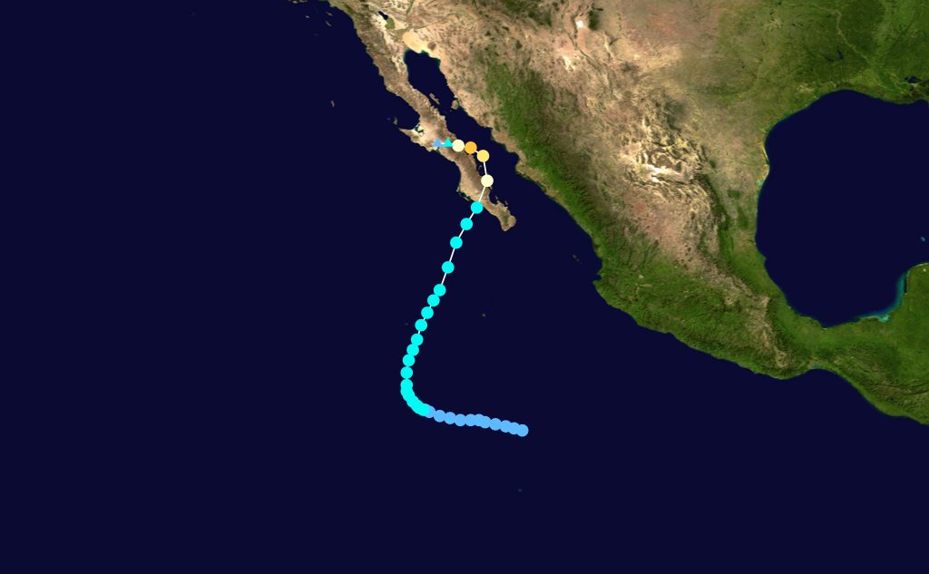
POST-TROPICAL CYCLONE NORBERT DISCUSSION NUMBER 24
NWS NATIONAL HURRICANE CENTER MIAMI FL EP142014
200 AM PDT MON SEP 08 2014
There has been no organized deep convection within Norbert's
circulation for more than 12 hours now, so the system is being
declared a post-tropical cyclone. The initial wind speed is lowered
to 35 kt in basic agreement with a 0524 UTC ASCAT-B overpass that
indicated wind vectors of around 32 kt in the southwestern quadrant.
Since Norbert is expected to move over even cooler waters, it is
presumed that a faster rate of decay should occur during the next
couple of days, with dissipation forecast in 2-3 days. The official
wind speed forecast shows slightly faster weakening than the
previous one, with the expectation that the remnant low of Norbert
will be very weak when it approaches the north-central Baja
California peninsula.
Norbert has been moving northwestward or 320/5 kt. The post-
tropical cyclone should turn toward the north and northeast during
the next couple of days ahead of a mid-tropospheric trough advancing
eastward offshore of the California coast. In 2-3 days, the shallow
remnant circulation should be pushed east-northeastward or eastward
by the low-level flow toward the coast of the northern Baja
California peninsula prior to dissipation. The official track
forecast is essentially the same as the previous one and in best
agreement with the multi-model consensus TVCE.
Although Norbert is weakening, tropical moisture should continue to
spread northward across northern Mexico and the southwestern United
States. This could result in heavy rains and life-threatening flash
flooding in these area during the next day or two. Please see
information from your local weather office for more details.
This is the last advisory issued by the National Hurricane Center
on Norbert. For future information on the post-tropical cyclone,
please see High Seas Forecasts issued by the National Weather
Service under AWIPS header NFDHSFEP1 and WMO header FZPN01 KWBC.
FORECAST POSITIONS AND MAX WINDS
INIT 08/0900Z 27.4N 118.3W 35 KT 40 MPH...POST-TROPICAL
12H 08/1800Z 27.7N 118.3W 30 KT 35 MPH...POST-TROP/REMNT LOW
24H 09/0600Z 28.5N 118.2W 25 KT 30 MPH...POST-TROP/REMNT LOW
36H 09/1800Z 29.0N 117.7W 20 KT 25 MPH...POST-TROP/REMNT LOW
48H 10/0600Z 29.3N 116.9W 15 KT 15 MPH...POST-TROP/REMNT LOW
72H 11/0600Z...DISSIPATED
$$
Forecaster Kimberlain
0 likes
Visit the Caribbean-Central America Weather Thread where you can find at first post web cams,radars
and observations from Caribbean basin members Click Here
and observations from Caribbean basin members Click Here


Re: EPAC: NORBERT - Hurricane
Cyclenall wrote:WeatherGuesser wrote:NDG wrote:If San Diego gets 4 sprinkles out of the left overs of Norbert is going to be a lot. People in Social Media that were calling for a tropical storm to affect SoCal I am wondering what they have to say to their followers, if they have any left, maybe blame the GFS, lol.
That's why I was waiting and watching before saying much. I didn't understand why the media was picking up on it so soon.
I didn't see anything in the media here but hearing this is funny. Anyone who knows anything about the Epac is aware of how tropical cyclones moving north towards California fare terribly and pretty much all become naked swirls long beforehand. Mets, experts, history all do. I know why the media picks up on it. For a few hours Norbert looked to be in an interesting placement with its major status.Yellow Evan wrote:That came apart fast.
It did, this is one of the fastest collapses I've ever seen for a non-mountain hitting TC. The last time something fell apart like that was a mountain bound cyclone. Went from major 105 knot hurricane at 5:00 am Sat to a close to naked swirl at 5:00 am Sun morning. Don't often see a 65 knot naked swirl with a piece of convection hanging off!!
I wouldn't be so quick to dismiss the impact Norbert and its remnants will have on SoCal and Arizona.
NWS Phoenix wrote: AREA FORECAST DISCUSSION
NATIONAL WEATHER SERVICE PHOENIX AZ
1000 AM MST MON SEP 8 2014
.SYNOPSIS...
MOISTURE WILL REMAIN IN PLACE ACROSS THE REGION FOR THE NEXT SEVERAL
DAYS AS FORMER HURRICANE NORBERT APPROACHES THE SOUTHERN CALIFORNIA
COAST. SHOWERS AND THUNDERSTORMS ARE EXPECTED AT TIMES THROUGH
TUESDAY...WITH SOME LOCATIONS POSSIBLY SEEING BRIEF PERIODS OF HEAVY
RAIN. A GRADUAL DRYING TREND IS EXPECTED TO BEGIN BY THE MIDDLE OF
THE WEEK AS HIGH PRESSURE SLOWLY REBUILDS OVER THE REGION.
&&
.DISCUSSION...
RECORD AMOUNTS OF ATMOSPHERIC MOISTURE HAVE SURGED INTO THE REGION
WITH 12Z KTWC SOUNDING SAMPLING 2.03 INCH PWAT (A RECORD FOR THE
MONTH OF SEPTEMBER). COMBINED WITH ASCENT FROM A WAVE CAUGHT BETWEEN
THE OUTER CIRCULATION OF WHAT WAS NORBERT AND A WAVE IN THE WESTERLY
FLOW ENTERING THE SIERRA...ALL-TIME RECORD RAINFALL HAS FALLEN
THROUGHOUT THE PHOENIX METRO AREA. SKY HARBOR HAS RECORDED 3.29
INCHES OF RAIN BREAKING THE CALENDAR DAY RECORD OF 2.91 INCHES SET
BACK IN 1933.
ADDITIONAL CONVECTION OVER SERN ARIZONA WAS PUSHING NORTH IN
ASSOCIATION WITH A WAVE IN THE H7-H5 LAYER. THIS RAINFALL WILL BE
FOCUSED ACROSS THE SERN PARTS OF THE FORECAST FOR THE REMAINDER OF
THE DAY...WITH SUBSIDENCE AND A MORE STABLE ENVIRONMENT MOVING INTO
PARTS OF WESTERN AND CENTRAL ARIZONA. ON THE OTHER
HAND...INSTABILITY WAS BUILDING OVER SERN CALIFORNIA WITH ANOTHER
WAVE LIFTING INTO SERN NEVADA...SO ADDITIONAL THUNDERSTORM
DEVELOPMENT IS CERTAINLY POSSIBLE THERE.

I-10 in Phoenix
0 likes
-
Yellow Evan
- Professional-Met
- Posts: 16241
- Age: 27
- Joined: Fri Jul 15, 2011 12:48 pm
- Location: Henderson, Nevada/Honolulu, HI
- Contact:


Who is online
Users browsing this forum: No registered users and 36 guests