ATL: INVEST 92L - Discussion
Moderator: S2k Moderators
-
tropicwatch

- Category 5

- Posts: 3426
- Age: 62
- Joined: Sat Jun 02, 2007 10:01 am
- Location: The Villages, Florida
- Contact:
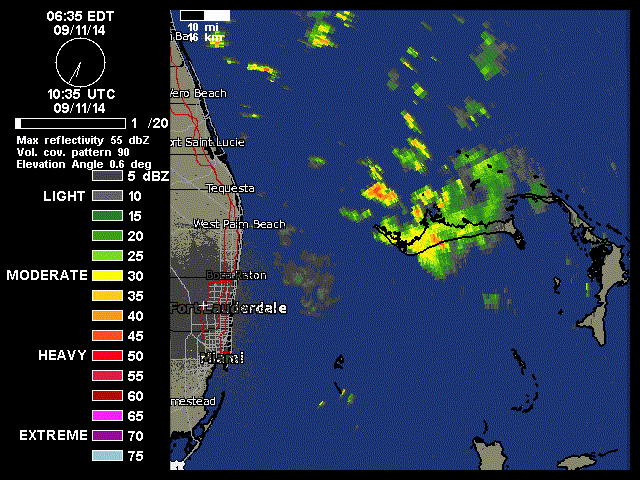
Looking at the long range radar it appears to be a little west of where you have it NDG.
0 likes
Tropicwatch
Agnes 72', Eloise 75, Elena 85', Kate 85', Charley 86', Florence 88', Beryl 94', Dean 95', Erin 95', Opal 95', Earl 98', Georges 98', Ivan 2004', Arlene 2005', Dennis 2005', Ida 2009' Debby 2012' Irma 2017' Michael 2018'
Agnes 72', Eloise 75, Elena 85', Kate 85', Charley 86', Florence 88', Beryl 94', Dean 95', Erin 95', Opal 95', Earl 98', Georges 98', Ivan 2004', Arlene 2005', Dennis 2005', Ida 2009' Debby 2012' Irma 2017' Michael 2018'
-
tolakram
- Admin

- Posts: 20186
- Age: 62
- Joined: Sun Aug 27, 2006 8:23 pm
- Location: Florence, KY (name is Mark)
Re: ATL: INVEST 92L - Discussion
0 likes
M a r k
- - - - -
Join us in chat: Storm2K Chatroom Invite. Android and IOS apps also available.
The posts in this forum are NOT official forecasts and should not be used as such. Posts are NOT endorsed by any professional institution or STORM2K.org. For official information and forecasts, please refer to NHC and NWS products.
-
tolakram
- Admin
- Posts: 20186
- Age: 62
- Joined: Sun Aug 27, 2006 8:23 pm
- Location: Florence, KY (name is Mark)
Re: ATL: INVEST 92L - Discussion
saved blurry radar loop
0 likes
M a r k
- - - - -
Join us in chat: Storm2K Chatroom Invite. Android and IOS apps also available.
The posts in this forum are NOT official forecasts and should not be used as such. Posts are NOT endorsed by any professional institution or STORM2K.org. For official information and forecasts, please refer to NHC and NWS products.
- - - - -
Join us in chat: Storm2K Chatroom Invite. Android and IOS apps also available.
The posts in this forum are NOT official forecasts and should not be used as such. Posts are NOT endorsed by any professional institution or STORM2K.org. For official information and forecasts, please refer to NHC and NWS products.

Re:
panamatropicwatch wrote:Looking at the long range radar it appears to be a little west of where you have it NDG.
But visible satellite loop and surface reports from the northern Bahamas show that it is further east than what the radar shows, at that distance radar is catching rainfall further up into the atmosphere and not as close to the surface as the short range.
0 likes

-
weatherfanatic
- Tropical Depression

- Posts: 58
- Age: 44
- Joined: Sun Jun 29, 2014 7:52 am
- Location: Yonkers, NY
Man, I was hoping to see a better organized storm this morning. Looks like that dry air is getting in there as stated. Sgetti has it all over the place, so IMO maybe in 5 days or so we may have to watch it for more significant development but for now doesn't look like it can do much. Will we get anything exciting to watch this year other than Arthur, yes we had other storms but that was the only one that was a threat and did hit land. I agree after reading the talk last night, size does not matter at all, if you have a LLC and high winds like Andrew destruction is just as bad as with a big storm just not as widespread. Living in NY I went through Sandy and I have never been in such a big widespread damage zone in my life, I was also in gloria and Bob which did damage but I do not remember them like I do Sandy. Lets see if this thing can get far snough south and start firing again today! Don't give up my tropical enthusiests!
0 likes
This post is NOT AN OFFICIAL FORECAST and should not be used as such. It is just the opinion of the poster and may or may not be backed by sound meteorological data. It is NOT endorsed by any professional institution including storm2k.org. For Official Information please refer to the NHC and NWS products.
-
wxman57

- Moderator-Pro Met

- Posts: 23175
- Age: 68
- Joined: Sat Jun 21, 2003 8:06 pm
- Location: Houston, TX (southwest)
Re: Re:
NDG wrote:panamatropicwatch wrote:Looking at the long range radar it appears to be a little west of where you have it NDG.
But visible satellite loop and surface reports from the northern Bahamas show that it is further east than what the radar shows, at that distance radar is catching rainfall further up into the atmosphere and not as close to the surface as the short range.
Good observation. I put it around 27.7N / 77.4W - well east of the radar (mid-level) center. It's an indication that it's now being hit by increasing NE-ENE shear. Development still looks unlikely, but it will bring rain to Florida over the next 36 hours. Conditions in the Gulf do not look favorable for development.

0 likes
-
jlauderdal
- S2K Supporter

- Posts: 7240
- Joined: Wed May 19, 2004 5:46 am
- Location: NE Fort Lauderdale
- Contact:


-
gatorcane

- S2K Supporter
- Posts: 23708
- Age: 48
- Joined: Sun Mar 13, 2005 3:54 pm
- Location: Boca Raton, FL
Re: Re:
wxman57 wrote:NDG wrote:panamatropicwatch wrote:Looking at the long range radar it appears to be a little west of where you have it NDG.
But visible satellite loop and surface reports from the northern Bahamas show that it is further east than what the radar shows, at that distance radar is catching rainfall further up into the atmosphere and not as close to the surface as the short range.
Good observation. I put it around 27.7N / 77.4W - well east of the radar (mid-level) center. It's an indication that it's now being hit by increasing NE-ENE shear. Development still looks unlikely, but it will bring rain to Florida over the next 36 hours. Conditions in the Gulf do not look favorable for development.
http://home.comcast.net/~cgh57/92La.JPG
Wxman, love the detailed graphic thanks. I see the llc where you have it too. I don't see the ENE/NE shear hitting it yet though. Still seems to be at the North-Central Florida latitude a couple of hundred miles to the north or so...it almost seems like there is some west shear at the South Florida latitude hitting the system.
0 likes

Re: ATL: INVEST 92L - Discussion
Funny how this system seems to build convection during the day and dissipate it at night.
0 likes
-
Stormcenter
- S2K Supporter
- Posts: 6689
- Joined: Wed Sep 03, 2003 11:27 am
- Location: Houston, TX
All I have to say it's Sept. so beware of anything that's in the GOM during that tiime if in fact it makes in there. IMO
Last edited by Stormcenter on Thu Sep 11, 2014 9:29 am, edited 1 time in total.
0 likes
-
tropicwatch
- Category 5
- Posts: 3426
- Age: 62
- Joined: Sat Jun 02, 2007 10:01 am
- Location: The Villages, Florida
- Contact:
Well the convection continues to build and expand this morning albeit to the west and south so far.

0 likes
Tropicwatch
Agnes 72', Eloise 75, Elena 85', Kate 85', Charley 86', Florence 88', Beryl 94', Dean 95', Erin 95', Opal 95', Earl 98', Georges 98', Ivan 2004', Arlene 2005', Dennis 2005', Ida 2009' Debby 2012' Irma 2017' Michael 2018'
Agnes 72', Eloise 75, Elena 85', Kate 85', Charley 86', Florence 88', Beryl 94', Dean 95', Erin 95', Opal 95', Earl 98', Georges 98', Ivan 2004', Arlene 2005', Dennis 2005', Ida 2009' Debby 2012' Irma 2017' Michael 2018'
-
gatorcane
- S2K Supporter
- Posts: 23708
- Age: 48
- Joined: Sun Mar 13, 2005 3:54 pm
- Location: Boca Raton, FL
Re: ATL: INVEST 92L - Discussion
ronjon wrote:Funny how this system seems to build convection during the day and dissipate it at night.
Yeah very interesting. It's on an increasing convection trend again. Actually looks a little more organized the past several hours. If that ENE/NE shear stays just to the north, then we may see some organization. Water temps are around 85F where it is heading. My take on the 00Z ECMWF is that it has delayed the onset of this shear some as it shows a closed low (doesn't look sheared) 24 hours from 00Z. The ECMWF also barely moves it in 24 hours.
0 likes


Re: Re:
gatorcane wrote:Wxman, love the detailed graphic thanks. I see the llc where you have it too. I don't see the ENE/NE shear hitting it yet though. Still seems to be at the North-Central Florida latitude a couple of hundred miles to the north or so...it almost seems like there is some west shear at the South Florida latitude hitting the system.
Well the llc (or what is of it) is away from the best convection which is to the w/sw, product of ENE shear due to the strengthening SE ridge. Convection is going further away from the shear.
0 likes
The above post and any post by Ntxw is NOT an official forecast and should not be used as such. It is just the opinion of the poster and may or may not be backed by sound meteorological data. It is NOT endorsed by any professional institution including Storm2k. For official information, please refer to NWS products.
Help support Storm2K!

-
Weatherboy1

- Category 5
- Posts: 1190
- Age: 50
- Joined: Mon Jul 05, 2004 1:50 pm
- Location: Jupiter/Sarasota, FL
Well, as I said yesterday, I didn't expect much from 92 given the limited window for strengthening before it moves into the FL east coast - and I probably should've thrown in the mention of increasing shear. At most, I see a minimal TS here ... if that. Certainly not like Jeanne moving onto my doorstep from roughly same area in 2004!
As always, just my opinion, listen to the experts, etc. ...
As always, just my opinion, listen to the experts, etc. ...
0 likes
-
wzrgirl1

- S2K Supporter
- Posts: 1360
- Joined: Sat Sep 04, 2004 6:44 am
- Location: Pembroke Pines, Florida
Re: ATL: INVEST 92L - Discussion
Well you all may not expect anything but I just got an update from Max Mayfield that they were upgrading to TD 6 @ 11:00
0 likes
-
tropicwatch
- Category 5
- Posts: 3426
- Age: 62
- Joined: Sat Jun 02, 2007 10:01 am
- Location: The Villages, Florida
- Contact:
0 likes
Tropicwatch
Agnes 72', Eloise 75, Elena 85', Kate 85', Charley 86', Florence 88', Beryl 94', Dean 95', Erin 95', Opal 95', Earl 98', Georges 98', Ivan 2004', Arlene 2005', Dennis 2005', Ida 2009' Debby 2012' Irma 2017' Michael 2018'
Agnes 72', Eloise 75, Elena 85', Kate 85', Charley 86', Florence 88', Beryl 94', Dean 95', Erin 95', Opal 95', Earl 98', Georges 98', Ivan 2004', Arlene 2005', Dennis 2005', Ida 2009' Debby 2012' Irma 2017' Michael 2018'
-
wzrgirl1
- S2K Supporter
- Posts: 1360
- Joined: Sat Sep 04, 2004 6:44 am
- Location: Pembroke Pines, Florida
Re: ATL: INVEST 92L - Discussion
The thread should be changed as soon as advisories come out.
0 likes
Who is online
Users browsing this forum: No registered users and 37 guests