ATL: INVEST 92L - Discussion
Moderator: S2k Moderators

If this organizes enough, are there enough land stations and buoys that they would upgrade without recon?
0 likes
The above post is not official and should not be used as such. It is the opinion of the poster and may or may not be backed by sound meteorological data. It is not endorsed by any professional institution or storm2k.org. For official information, please refer to the NHC and NWS products.

-
tropicwatch

- Category 5

- Posts: 3426
- Age: 62
- Joined: Sat Jun 02, 2007 10:01 am
- Location: The Villages, Florida
- Contact:
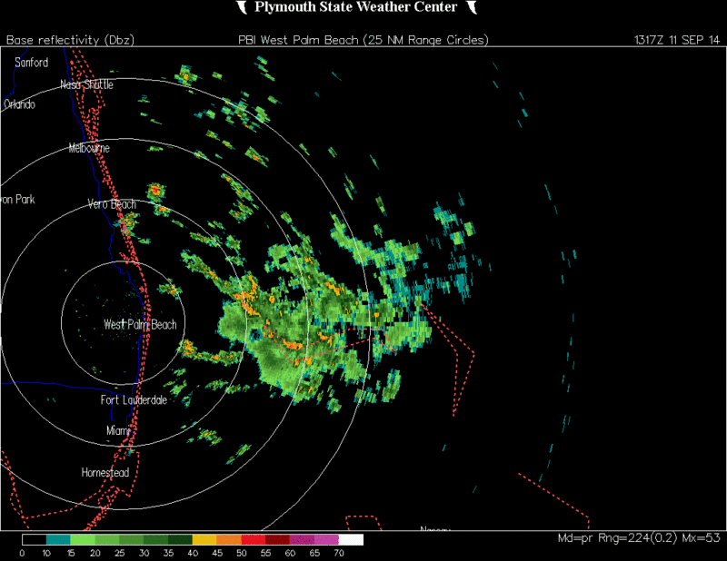
Vorticity appears to on the increase and not so elongated.

0 likes
Tropicwatch
Agnes 72', Eloise 75, Elena 85', Kate 85', Charley 86', Florence 88', Beryl 94', Dean 95', Erin 95', Opal 95', Earl 98', Georges 98', Ivan 2004', Arlene 2005', Dennis 2005', Ida 2009' Debby 2012' Irma 2017' Michael 2018'
Agnes 72', Eloise 75, Elena 85', Kate 85', Charley 86', Florence 88', Beryl 94', Dean 95', Erin 95', Opal 95', Earl 98', Georges 98', Ivan 2004', Arlene 2005', Dennis 2005', Ida 2009' Debby 2012' Irma 2017' Michael 2018'

Re: ATL: INVEST 92L - Discussion
There is some slightly moister air moving in from the northeast.
I would have liked to see what recon would have found for surface pressures.
Could enven make TS status before 1st landfall if it overcomes the dry air.
I would have liked to see what recon would have found for surface pressures.
Could enven make TS status before 1st landfall if it overcomes the dry air.
0 likes


Re: ATL: INVEST 92L - Discussion
LLC still seems off the the northeast. From the CIMSS vorticity plots, 700 mb/mid-level vorticity seems to be increasing. I would think it's best shot is to ditch the old LLC and mix a new one under this convection down to the surface.
0 likes

Re:
gatorcane wrote:Convection really starting to get going again...lastest blowup is more circular in appearance:
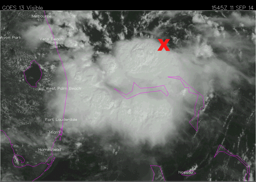
low and mid level circulations look to be dislocated. There is an apparent radar mid-level circ near West End, but the low level is just north of the Abacos - this latest blow up of convection looks to be in between the low and mid-level circ . . . interesting
0 likes

-
jlauderdal
- S2K Supporter

- Posts: 7240
- Joined: Wed May 19, 2004 5:46 am
- Location: NE Fort Lauderdale
- Contact:
Re:
gatorcane wrote:Also the invest doesn't seem to be moving much at all. Maybe a slow drift west. It's interesting to note the ECMWF doesn't move it that much the next 24 hours.
there is a cell just to your north..coming right down the coast, you first then me..looks like its all building to the west but its been real slow...heavy rain producer if the convection can maintain itself
we had the noname storm about 15 years ago that was a monster rain producer
0 likes
-
jlauderdal
- S2K Supporter
- Posts: 7240
- Joined: Wed May 19, 2004 5:46 am
- Location: NE Fort Lauderdale
- Contact:

Re: Re:
jlauderdal wrote:gatorcane wrote:Also the invest doesn't seem to be moving much at all. Maybe a slow drift west. It's interesting to note the ECMWF doesn't move it that much the next 24 hours.
there is a cell just to your north..coming right down the coast, you first then me..looks like its all building to the west but its been real slow...heavy rain producer if the convection can maintain itself
we had the noname storm about 15 years ago that was a monster rain producer
Was that the Leslie precursor system in 2000?
0 likes
The above post is not official and should not be used as such. It is the opinion of the poster and may or may not be backed by sound meteorological data. It is not endorsed by any professional institution or storm2k.org. For official information, please refer to the NHC and NWS products.
-
jlauderdal
- S2K Supporter
- Posts: 7240
- Joined: Wed May 19, 2004 5:46 am
- Location: NE Fort Lauderdale
- Contact:
Re: Re:
Hammy wrote:jlauderdal wrote:gatorcane wrote:Also the invest doesn't seem to be moving much at all. Maybe a slow drift west. It's interesting to note the ECMWF doesn't move it that much the next 24 hours.
there is a cell just to your north..coming right down the coast, you first then me..looks like its all building to the west but its been real slow...heavy rain producer if the convection can maintain itself
we had the noname storm about 15 years ago that was a monster rain producer
Was that the Leslie precursor system in 2000?
that sounds right...i remember a kid went onto flood waters that had a live wire and several more followed him going for the rescue and they were all electrocuted
thats why i think its foolish that the media insists on putting on waders and going into flood waters, sets a horrible example and provides almost no value, we know the water is high and they dont need to stand in it as reference
0 likes
-
Bocadude85

- Category 5
- Posts: 2991
- Age: 39
- Joined: Mon Apr 18, 2005 2:20 pm
- Location: Honolulu,Hi
Re:
gatorcane wrote:Also the invest doesn't seem to be moving much at all. Maybe a slow drift west. It's interesting to note the ECMWF doesn't move it that much the next 24 hours.
Last nights Euro also showed a closed low at 24 hours.
0 likes
-
Blown Away

- S2K Supporter
- Posts: 10253
- Joined: Wed May 26, 2004 6:17 am
Re: Re:
Bocadude85 wrote:gatorcane wrote:Also the invest doesn't seem to be moving much at all. Maybe a slow drift west. It's interesting to note the ECMWF doesn't move it that much the next 24 hours.
Last nights Euro also showed a closed low at 24 hours.

The Low is tagged and predicted not to move much in next 24 hours. Slight WSW drift from current position.
0 likes
Hurricane Eye Experience: David 79, Irene 99, Frances 04, Jeanne 04, Wilma 05… Hurricane Brush Experience: Andrew 92, Erin 95, Floyd 99, Matthew 16, Irma 17, Ian 22, Nicole 22…
-
Weatherboy1

- Category 5
- Posts: 1190
- Age: 50
- Joined: Mon Jul 05, 2004 1:50 pm
- Location: Jupiter/Sarasota, FL
Yes, the firing up of convection is clearly more vigorous today. But it is still not co-located with the center of the low based on visible satellite. Light rain now falling here in west Jupiter, but no wind really at all. Unless this system really stalls/slows and/or the convection can blow up right over the center, I don't think we're talking about more than a TD or low-end TS ... at least until this thing gets into the Gulf as most models suggest.
Just my opinion, listen to the experts, etc.
Just my opinion, listen to the experts, etc.
0 likes
Who is online
Users browsing this forum: No registered users and 68 guests