ATL: INVEST 92L - Discussion

Moderator: S2k Moderators

Message
Author
jlauderdal
S2K Supporter
S2K Supporter
Posts: 7177
Joined: Wed May 19, 2004 5:46 am
Location: NE Fort Lauderdale
Contact:

Re: ATL: INVEST 92L - Discussion

#461 Postby jlauderdal » Thu Sep 11, 2014 6:34 pm

fci wrote:
jlauderdal wrote:
TARHEELPROGRAMMER wrote:Anyone want to give an update on what they think is going on with the system right now?

well the rain has stopped in ne fll..system.is weak and should stay real weak


Rain has passed and a big slot of dry is over us now.
Rain was heavy only briefly.
Apparently only very few areas got over an inch, inland; and might have been enhanced by sea breeze interaction.

pouring again...need the rain, its been dry on the coast...more on the way next few days
0 likes   

User avatar
HeeBGBz
Category 1
Category 1
Posts: 341
Age: 70
Joined: Sun Sep 03, 2006 3:25 pm
Location: Biloxi, MS

Re: ATL: INVEST 92L - Discussion

#462 Postby HeeBGBz » Thu Sep 11, 2014 6:39 pm

When this enters the gulf, is it likely to merge with the buildup in the BOC? Or will it compete for energy?
0 likes   

User avatar
Hammy
Category 5
Category 5
Posts: 5849
Age: 41
Joined: Fri May 25, 2012 5:25 pm
Contact:

#463 Postby Hammy » Thu Sep 11, 2014 6:59 pm

down to 20% in the short term, but up to 40% for five day, so it looks like development over the gulf is becoming more likely.
0 likes   
The above post is not official and should not be used as such. It is the opinion of the poster and may or may not be backed by sound meteorological data. It is not endorsed by any professional institution or storm2k.org. For official information, please refer to the NHC and NWS products.

floridasun78
Category 5
Category 5
Posts: 3755
Joined: Sun May 17, 2009 10:16 pm
Location: miami fl

#464 Postby floridasun78 » Thu Sep 11, 2014 7:05 pm

TROPICAL WEATHER OUTLOOK
NWS NATIONAL HURRICANE CENTER MIAMI FL
800 PM EDT THU SEP 11 2014

For the North Atlantic...Caribbean Sea and the Gulf of Mexico:

The National Hurricane Center is issuing advisories on Tropical
Depression Six, located several hundred miles west of the Cape Verde
Islands.

1. Satellite, radar and surface observations show that the area of
low pressure centered over the northwestern Bahamas is moving
slowly west-southwestward toward southern Florida. The shower
activity associated with the low has not become any better
organized during the past few hours, and strong upper-level winds
as well as the interaction with the Florida peninsula will likely
inhibit development tonight and Friday. Once the low moves westward
over the southeastern Gulf of Mexico during the weekend, conditions
could become a little more conducive for tropical cyclone formation.
Regardless of development, this low will bring locally heavy rains
to portions of southern Florida and the Florida Keys during the next
couple of days.
* Formation chance through 48 hours...low...20 percent.
* Formation chance through 5 days...medium...40 percent.
0 likes   

TARHEELPROGRAMMER

#465 Postby TARHEELPROGRAMMER » Thu Sep 11, 2014 7:10 pm

So, I was right when I said it was moving southward.
0 likes   

User avatar
LaBreeze
Category 5
Category 5
Posts: 1497
Joined: Thu Sep 04, 2003 1:57 pm
Location: SW Louisiana

Re: ATL: INVEST 92L - Discussion

#466 Postby LaBreeze » Thu Sep 11, 2014 7:24 pm

Local met mentioned this evening that the more reliable models have this "system" making its way across the GOM and parking itself in the western GOM. He seems to think that it will enhance our rain chances here in SW LA around Tuesday or Wednesday of next week.
0 likes   
Audrey (1957), Carla (1961), Hilda (1964), Betsy (1965), Edith (1971), Carmen (1974), Danny (1985), Juan (1985), Andrew (1992), Lili (2002), Rita (2005), Gustav (2008), Ike (2008), and stuck in the eye of Iniki (1992) while vacationing in Kauai.

Not an official forecast by any means.

User avatar
MGC
S2K Supporter
S2K Supporter
Posts: 5885
Joined: Sun Mar 23, 2003 9:05 pm
Location: Pass Christian MS, or what is left.

Re: ATL: INVEST 92L - Discussion

#467 Postby MGC » Thu Sep 11, 2014 7:26 pm

Yes, it is moving to the south...but mostly to the west. WSW......MGC
0 likes   

User avatar
Nimbus
Category 5
Category 5
Posts: 5274
Joined: Mon Jul 19, 2004 10:54 am

Re: ATL: INVEST 92L - Discussion

#468 Postby Nimbus » Thu Sep 11, 2014 7:31 pm

blp wrote:Quite clear on this loop where the llc is. That shear lets up one inch this thing is a TD. Be careful tonight.

http://www.ssd.noaa.gov/PS/TROP/floaters/92L/imagery/vis_lalo-animated.gif


I've been watching the SPGF1 buoy and the winds shifted from NW to a lull of 6 knots then back to 19 knots from the SW

http://www.ndbc.noaa.gov/station_page.php?station=spgf1

Any low pressure must be over a small area about the size of a water spout.

When that dry air came sinking in this morning that has really helped Florida.
Hopefully 92l won't reform tomorrow morning as has been the pattern.
0 likes   

User avatar
NDG
S2K Supporter
S2K Supporter
Posts: 15446
Joined: Sun Jul 09, 2006 10:14 pm
Location: Orlando, FL

Re: ATL: INVEST 92L - Discussion

#469 Postby NDG » Thu Sep 11, 2014 7:34 pm

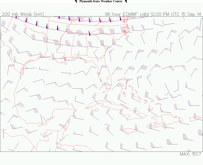
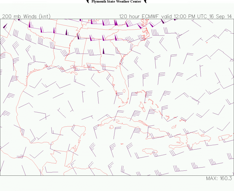
Just noticed that both the GFS and ECMWF now picture better UL conditions in the central and western GOM by late weekend into early next week, if it survives the next couple of days it may indeed get better organized by then.

Image
Image
0 likes   

User avatar
blp
Category 5
Category 5
Posts: 2840
Age: 46
Joined: Thu Sep 09, 2004 7:51 pm
Location: Miami, FL
Contact:

Re: ATL: INVEST 92L - Discussion

#470 Postby blp » Thu Sep 11, 2014 7:50 pm

Nimbus wrote:
blp wrote:Quite clear on this loop where the llc is. That shear lets up one inch this thing is a TD. Be careful tonight.

http://www.ssd.noaa.gov/PS/TROP/floaters/92L/imagery/vis_lalo-animated.gif


I've been watching the SPGF1 buoy and the winds shifted from NW to a lull of 6 knots then back to 19 knots from the SW

http://www.ndbc.noaa.gov/station_page.php?station=spgf1

Any low pressure must be over a small area about the size of a water spout.

When that dry air came sinking in this morning that has really helped Florida.
Hopefully 92l won't reform tomorrow morning as has been the pattern.


Yea that is the area with the lowest pressure right now and has been slowly falling all afternoon. The llc looks to be very close to this area.
0 likes   
The following post is NOT an official forecast and should not be used as such. It is just the opinion of the poster and may or may not be backed by sound meteorological data. It is NOT endorsed by any professional institution including storm2k.org For Official Information please refer to the NHC and NWS products.

User avatar
fci
S2K Supporter
S2K Supporter
Posts: 3323
Joined: Tue Sep 14, 2004 10:29 am
Location: Lake Worth, FL

Re: ATL: INVEST 92L - Discussion

#471 Postby fci » Thu Sep 11, 2014 8:38 pm

fci wrote:
jlauderdal wrote:
TARHEELPROGRAMMER wrote:Anyone want to give an update on what they think is going on with the system right now?


Rain has passed and a big slot of dry is over us now.
Rain was heavy only briefly.
Apparently only very few areas got over an inch, inland; and might have been enhanced by sea breeze interaction.

pouring again...need the rain, its been dry on the coast...more on the way next few days


Some training going in now in Palm Beach County but it looks like not much left behind it.
Expect sunny skies by Friday afternoon.
I suspect there have lulls in Ft. Lauderdale like we has in PBC earlier.
0 likes   
Personal Forecast Disclaimer:
My posts are just my opinion and are most likely not backed by sound meteorological data. They are NOT endorsed by any professional institution or storm2k.org. For official information, please refer to the NHC and NWS products.
Bottom line is that I am just expressing my opinion!!!

User avatar
Sambucol
Tropical Storm
Tropical Storm
Posts: 223
Joined: Wed Jul 25, 2007 5:09 pm

Re: ATL: INVEST 92L - Discussion

#472 Postby Sambucol » Thu Sep 11, 2014 8:42 pm

LaBreeze wrote:Local met mentioned this evening that the more reliable models have this "system" making its way across the GOM and parking itself in the western GOM. He seems to think that it will enhance our rain chances here in SW LA around Tuesday or Wednesday of next week.

How long will be parked? Did the met say it would get it's act together in the GOM?
0 likes   

User avatar
MGC
S2K Supporter
S2K Supporter
Posts: 5885
Joined: Sun Mar 23, 2003 9:05 pm
Location: Pass Christian MS, or what is left.

Re: ATL: INVEST 92L - Discussion

#473 Postby MGC » Thu Sep 11, 2014 9:01 pm

Band of precip moving into Florida's east coast looks quite tropical. Looks like the dry air has dried up all the precip east of that band though.....MGC
0 likes   

Sanibel
Category 5
Category 5
Posts: 10375
Joined: Mon Aug 30, 2004 11:06 pm
Location: Offshore SW Florida

Re: ATL: INVEST 92L - Discussion

#474 Postby Sanibel » Thu Sep 11, 2014 9:25 pm

Totally naked now (the storm not me). Dead calm over here and humid. Shear expected to ride with 92L for next 48 hours.
0 likes   

User avatar
LaBreeze
Category 5
Category 5
Posts: 1497
Joined: Thu Sep 04, 2003 1:57 pm
Location: SW Louisiana

Re: ATL: INVEST 92L - Discussion

#475 Postby LaBreeze » Thu Sep 11, 2014 10:00 pm

Sambucol wrote:
LaBreeze wrote:Local met mentioned this evening that the more reliable models have this "system" making its way across the GOM and parking itself in the western GOM. He seems to think that it will enhance our rain chances here in SW LA around Tuesday or Wednesday of next week.

How long will be parked? Did the met say it would get it's act together in the GOM?

He didn't go that far out on the limb - he seemed to say that it would be there for a day or two and then no forecast movement was given after that. I'll see what he says during the 10:00 news.
0 likes   
Audrey (1957), Carla (1961), Hilda (1964), Betsy (1965), Edith (1971), Carmen (1974), Danny (1985), Juan (1985), Andrew (1992), Lili (2002), Rita (2005), Gustav (2008), Ike (2008), and stuck in the eye of Iniki (1992) while vacationing in Kauai.

Not an official forecast by any means.

User avatar
baytownwx
Tropical Depression
Tropical Depression
Posts: 66
Joined: Tue Jun 19, 2012 10:38 am

Re: ATL: INVEST 92L - Discussion

#476 Postby baytownwx » Thu Sep 11, 2014 10:13 pm

Yes, looks naked right now..
Image
0 likes   
The following post is NOT an official forecast and should not be used as such. It is just the opinion of the poster and may or may not be backed by sound meteorological data. It is NOT endorsed by storm2k.org.

hurricanehunter69
Category 1
Category 1
Posts: 342
Joined: Sun May 16, 2010 5:21 pm
Location: New Orleans

Re: ATL: INVEST 92L - Discussion

#477 Postby hurricanehunter69 » Thu Sep 11, 2014 11:20 pm

I've been studying water vapor loops in the gulf for about two days now, and I'm noticing an evolution of increasingly improving(conducive) conditions. This... IMO, is well...concerning to say the least. http://www.ssd.noaa.gov/goes/east/gmex/flash-wv.html
0 likes   

User avatar
fci
S2K Supporter
S2K Supporter
Posts: 3323
Joined: Tue Sep 14, 2004 10:29 am
Location: Lake Worth, FL

#478 Postby fci » Fri Sep 12, 2014 12:30 am

Area Flood Advisory for my area as it has been pouring all evening. So much for only about 1 inch!
Have had about 1.5 inches so far for Thursday up until now and it is still coming down.
Still should be over with sun coming out on Friday.
0 likes   
Personal Forecast Disclaimer:
My posts are just my opinion and are most likely not backed by sound meteorological data. They are NOT endorsed by any professional institution or storm2k.org. For official information, please refer to the NHC and NWS products.
Bottom line is that I am just expressing my opinion!!!

User avatar
LaBreeze
Category 5
Category 5
Posts: 1497
Joined: Thu Sep 04, 2003 1:57 pm
Location: SW Louisiana

Re: ATL: INVEST 92L - Discussion

#479 Postby LaBreeze » Fri Sep 12, 2014 1:09 am

hurricanehunter69 wrote:I've been studying water vapor loops in the gulf for about two days now, and I'm noticing an evolution of increasingly improving(conducive) conditions. This... IMO, is well...concerning to say the least. http://www.ssd.noaa.gov/goes/east/gmex/flash-wv.html

Concerning? Please, give us your thoughts on this.
0 likes   
Audrey (1957), Carla (1961), Hilda (1964), Betsy (1965), Edith (1971), Carmen (1974), Danny (1985), Juan (1985), Andrew (1992), Lili (2002), Rita (2005), Gustav (2008), Ike (2008), and stuck in the eye of Iniki (1992) while vacationing in Kauai.

Not an official forecast by any means.

User avatar
ronjon
Category 5
Category 5
Posts: 4811
Joined: Fri Aug 19, 2005 5:17 pm
Location: Hernando Beach, FL

Re: ATL: INVEST 92L - Discussion

#480 Postby ronjon » Fri Sep 12, 2014 5:54 am

Low center just west of WPB. Still getting northerly shear but may produce some heavy convection over the peninsula today.

http://radar.weather.gov/radar.php?product=NCR&rid=MLB&loop=yes
0 likes   


Return to “2014”

Who is online

Users browsing this forum: No registered users and 49 guests