ATL: INVEST 92L - Discussion

Moderator: S2k Moderators

Message
Author
jlauderdal
S2K Supporter
S2K Supporter
Posts: 7177
Joined: Wed May 19, 2004 5:46 am
Location: NE Fort Lauderdale
Contact:

Re: ATL: INVEST 92L - Discussion

#481 Postby jlauderdal » Fri Sep 12, 2014 5:57 am

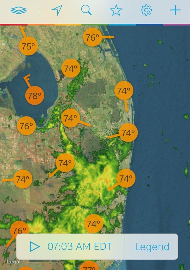
ronjon wrote:Low center just west of WPB. Still getting northerly shear but may produce some heavy convection over the peninsula today.

http://radar.weather.gov/radar.php?product=NCR&rid=MLB&loop=yes


looks to be stationary, very broad, sending precip into broward and dade....had big lighting around 230 am to my NW
0 likes   

User avatar
NDG
S2K Supporter
S2K Supporter
Posts: 15446
Joined: Sun Jul 09, 2006 10:14 pm
Location: Orlando, FL

Re: ATL: INVEST 92L - Discussion

#482 Postby NDG » Fri Sep 12, 2014 6:06 am

I agree about the low pressure center being west of West Palm this morning.

Image
0 likes   

jlauderdal
S2K Supporter
S2K Supporter
Posts: 7177
Joined: Wed May 19, 2004 5:46 am
Location: NE Fort Lauderdale
Contact:

Re: ATL: INVEST 92L - Discussion

#483 Postby jlauderdal » Fri Sep 12, 2014 6:35 am

we have sun now to the east
0 likes   

User avatar
cycloneye
Admin
Admin
Posts: 143886
Age: 68
Joined: Thu Oct 10, 2002 10:54 am
Location: San Juan, Puerto Rico

Re: ATL: INVEST 92L - Discussion

#484 Postby cycloneye » Fri Sep 12, 2014 6:49 am

. The broad area of low pressure has moved westward and is now
located over southern Florida just south of Lake Okeechobee. Shower
activity is currently poorly organized, and strong upper-level winds
as well as interaction with land will likely inhibit development of
this system today. Once the low moves over the southeastern Gulf of
Mexico, conditions could become a little more conducive for tropical
cyclone formation over the weekend while the system moves westward
at around 10 mph. Regardless of development, this low will continue
to bring locally heavy rains to portions of southern Florida and the
Florida Keys today and Saturday.
* Formation chance through 48 hours...low...20 percent.
* Formation chance through 5 days...medium...40 percent.
0 likes   
Visit the Caribbean-Central America Weather Thread where you can find at first post web cams,radars
and observations from Caribbean basin members Click Here

User avatar
Kohlecane
Category 2
Category 2
Posts: 591
Age: 33
Joined: Sun Jul 31, 2011 11:03 pm
Location: Beaufort, SC

Re: ATL: INVEST 92L - Discussion

#485 Postby Kohlecane » Fri Sep 12, 2014 7:01 am

Is there a COC? lol and Where is it located i can't tell..
0 likes   
Once I see the REDS and GREENS Converge on a Base Velocity. ... I'm There!!

This is NOT an Official Forecast....Just my Opinion. For official information, please refer to the NHC and NWS products.
HIGHLIGHTS : '13 El Reno Tornado : 2013 Storm Chaser Tour, Joaquin; SC flood event, Matthew '16, Lowcountry Snow storm Jan '18

User avatar
ronjon
Category 5
Category 5
Posts: 4811
Joined: Fri Aug 19, 2005 5:17 pm
Location: Hernando Beach, FL

Re: ATL: INVEST 92L - Discussion

#486 Postby ronjon » Fri Sep 12, 2014 7:22 am

Kohlecane wrote:Is there a COC? lol and Where is it located i can't tell..


You can easily see it on RAD - moving W-SW toward Naples. Just SE of Lake O (look for the half semi-circle). Actually won't be over land (and pretty swampy land at that) for very long before emerging in the GOM. Might get interesting in the GOM the next 10 days with 92L and another system progged coming up from the Yuc by the GFS next weekend.

http://radar.weather.gov/radar.php?product=NCR&rid=amx&loop=yes
0 likes   

User avatar
cycloneye
Admin
Admin
Posts: 143886
Age: 68
Joined: Thu Oct 10, 2002 10:54 am
Location: San Juan, Puerto Rico

Re: ATL: INVEST 92L - Discussion

#487 Postby cycloneye » Fri Sep 12, 2014 7:26 am

12z Best Track:

AL, 92, 2014091212, , BEST, 0, 267N, 805W, 25, 1012, LO
0 likes   
Visit the Caribbean-Central America Weather Thread where you can find at first post web cams,radars
and observations from Caribbean basin members Click Here

User avatar
Kohlecane
Category 2
Category 2
Posts: 591
Age: 33
Joined: Sun Jul 31, 2011 11:03 pm
Location: Beaufort, SC

Re: ATL: INVEST 92L - Discussion

#488 Postby Kohlecane » Fri Sep 12, 2014 7:26 am

ronjon wrote:
Kohlecane wrote:Is there a COC? lol and Where is it located i can't tell..


You can easily see it on RAD - moving W-SW toward Naples. Just SE of Lake O (look for the half semi-circle). Actually won't be over land (and pretty swampy land at that) for very long before emerging in the GOM. Might get interesting in the GOM the next 10 days with 92L and another system progged coming up from the Yuc by the GFS next weekend.

http://radar.weather.gov/radar.php?product=NCR&rid=amx&loop=yes


Thanks. And I Agree with the next week or so on whats to come.
0 likes   
Once I see the REDS and GREENS Converge on a Base Velocity. ... I'm There!!

This is NOT an Official Forecast....Just my Opinion. For official information, please refer to the NHC and NWS products.
HIGHLIGHTS : '13 El Reno Tornado : 2013 Storm Chaser Tour, Joaquin; SC flood event, Matthew '16, Lowcountry Snow storm Jan '18

jlauderdal
S2K Supporter
S2K Supporter
Posts: 7177
Joined: Wed May 19, 2004 5:46 am
Location: NE Fort Lauderdale
Contact:

Re: ATL: INVEST 92L - Discussion

#489 Postby jlauderdal » Fri Sep 12, 2014 7:28 am

ronjon wrote:
Kohlecane wrote:Is there a COC? lol and Where is it located i can't tell..


You can easily see it on RAD - moving W-SW toward Naples. Just SE of Lake O (look for the half semi-circle). Actually won't be over land (and pretty swampy land at that) for very long before emerging in the GOM. Might get interesting in the GOM the next 10 days with 92L and another system progged coming up from the Yuc by the GFS next weekend.

http://radar.weather.gov/radar.php?product=NCR&rid=amx&loop=yes


the swamp waters are warmer then the gulf FWIW which isnt much but its heading right through the everglades the next few hours...wont take much to get tstorms going today, need a little heating, not much
0 likes   

tolakram
Admin
Admin
Posts: 19990
Age: 61
Joined: Sun Aug 27, 2006 8:23 pm
Location: Florence, KY (name is Mark)

Re: ATL: INVEST 92L - Discussion

#490 Postby tolakram » Fri Sep 12, 2014 7:32 am

0 likes   
M a r k
- - - - -
Join us in chat: Storm2K Chatroom Invite. Android and IOS apps also available.

The posts in this forum are NOT official forecasts and should not be used as such. Posts are NOT endorsed by any professional institution or STORM2K.org. For official information and forecasts, please refer to NHC and NWS products.

hurricanehunter69
Category 1
Category 1
Posts: 342
Joined: Sun May 16, 2010 5:21 pm
Location: New Orleans

Re: ATL: INVEST 92L - Discussion

#491 Postby hurricanehunter69 » Fri Sep 12, 2014 7:40 am

LaBreeze wrote:
hurricanehunter69 wrote:I've been studying water vapor loops in the gulf for about two days now, and I'm noticing an evolution of increasingly improving(conducive) conditions. This... IMO, is well...concerning to say the least. http://www.ssd.noaa.gov/goes/east/gmex/flash-wv.html

Concerning? Please, give us your thoughts on this.

relatively speaking...nothing compared to Katrina conducive. But, much better than several days ago.
0 likes   

jlauderdal
S2K Supporter
S2K Supporter
Posts: 7177
Joined: Wed May 19, 2004 5:46 am
Location: NE Fort Lauderdale
Contact:

Re: ATL: INVEST 92L - Discussion

#492 Postby jlauderdal » Fri Sep 12, 2014 7:55 am

looks like a band developing offshore this morning...lets see if it can intensify and move onshore later
0 likes   

Senobia
Category 1
Category 1
Posts: 278
Joined: Sat Aug 05, 2006 2:59 pm
Location: Somewhere over the rainbow

Re: ATL: INVEST 92L - Discussion

#493 Postby Senobia » Fri Sep 12, 2014 8:09 am

This is the only thing I could find from local mets (SETX) and it's from yesterday morning:

A tropical low in the Northwestern Bahamas is moving to the west. It is expected to bring heavy rains to South Florida and enter the gulf. We will need to watch this one as high pressure over our region may not be strong enough to deflect it. Regardless, it is too early to tell exactly where is will go and how strong it will be when it get there.
0 likes   

Stormcenter
S2K Supporter
S2K Supporter
Posts: 6677
Joined: Wed Sep 03, 2003 11:27 am
Location: Houston, TX

#494 Postby Stormcenter » Fri Sep 12, 2014 8:14 am

Could be a serious rain maker for someone next week. IMO
0 likes   

User avatar
wxman57
Moderator-Pro Met
Moderator-Pro Met
Posts: 22951
Age: 67
Joined: Sat Jun 21, 2003 8:06 pm
Location: Houston, TX (southwest)

Re: ATL: INVEST 92L - Discussion

#495 Postby wxman57 » Fri Sep 12, 2014 8:15 am

The center is NE of Okeechobee (about 30 miles). Look at surface obs, not radar. It's very broad and free of convection.
0 likes   

User avatar
tropicwatch
Category 5
Category 5
Posts: 3364
Age: 61
Joined: Sat Jun 02, 2007 10:01 am
Location: Panama City Florida
Contact:

Re: ATL: INVEST 92L - Discussion

#496 Postby tropicwatch » Fri Sep 12, 2014 8:22 am

wxman57 wrote:The center is NE of Okeechobee (about 30 miles). Look at surface obs, not radar. It's very broad and free of convection.


I would have to agree, the lowest pressures 29.89 are being reported in the Lake Placid - Gator Cove area's.
0 likes   
Tropicwatch


Agnes 72', Eloise 75, Elena 85', Kate 85', Charley 86', Florence 88', Beryl 94', Dean 95', Erin 95', Opal 95', Earl 98', Georges 98', Ivan 2004', Arlene 2005', Dennis 2005', Ida 2009' Debby 2012' Irma 2017' Michael 2018'

User avatar
Blown Away
S2K Supporter
S2K Supporter
Posts: 10140
Joined: Wed May 26, 2004 6:17 am

Re: ATL: INVEST 92L - Discussion

#497 Postby Blown Away » Fri Sep 12, 2014 8:32 am

wxman57 wrote:The center is NE of Okeechobee (about 30 miles). Look at surface obs, not radar. It's very broad and free of convection.


Well, I'm 30 miles NE of Lake O, partly cloudy, gentle breeze, and a wonderful day... :D
0 likes   
Hurricane Eye Experience: David 79, Irene 99, Frances 04, Jeanne 04, Wilma 05... EYE COMING MY WAY IN 2024…
Hurricane Brush Experience: Andrew 92, Erin 95, Floyd 99, Matthew 16, Irma 17, Ian 22, Nicole 22…

User avatar
wxman57
Moderator-Pro Met
Moderator-Pro Met
Posts: 22951
Age: 67
Joined: Sat Jun 21, 2003 8:06 pm
Location: Houston, TX (southwest)

Re: ATL: INVEST 92L - Discussion

#498 Postby wxman57 » Fri Sep 12, 2014 8:37 am

Blown Away wrote:
Well, I'm 30 miles NE of Lake O, partly cloudy, gentle breeze, and a wonderful day... :D


Oh my God! You're in the eye! Take cover immediately! Winds will be switching to the opposition direction soon and will be just as strong as when you entered the eye (5-10 kts).
0 likes   

User avatar
tropicwatch
Category 5
Category 5
Posts: 3364
Age: 61
Joined: Sat Jun 02, 2007 10:01 am
Location: Panama City Florida
Contact:

#499 Postby tropicwatch » Fri Sep 12, 2014 8:39 am

Everything will be alright heat mizer 8-)
0 likes   
Tropicwatch


Agnes 72', Eloise 75, Elena 85', Kate 85', Charley 86', Florence 88', Beryl 94', Dean 95', Erin 95', Opal 95', Earl 98', Georges 98', Ivan 2004', Arlene 2005', Dennis 2005', Ida 2009' Debby 2012' Irma 2017' Michael 2018'

Sanibel
Category 5
Category 5
Posts: 10375
Joined: Mon Aug 30, 2004 11:06 pm
Location: Offshore SW Florida

Re: ATL: INVEST 92L - Discussion

#500 Postby Sanibel » Fri Sep 12, 2014 8:43 am

Powder puff of a system. Barely noticeable over here with sun and light breezes. There are low hanging clouds however.
0 likes   


Return to “2014”

Who is online

Users browsing this forum: No registered users and 48 guests