AL, 94, 2014091212, , BEST, 0, 196N, 944W, 20, 1009, DB, 0, , 0, 0, 0, 0,
AL, 94, 2014091218, , BEST, 0, 206N, 949W, 20, 1009, DB, 0, , 0, 0, 0, 0,
AL, 94, 2014091300, , BEST, 0, 213N, 957W, 20, 1008, DB, 34, NEQ, 0, 0, 0, 0, 1010, 120, 60, 0, 0, L, 0,
Thread at Talking Tropics that was the topic for this area.
viewtopic.php?f=31&t=116743&p=2413682#p2413682
ATL: INVEST 94L - Discussion
Moderator: S2k Moderators
-
cycloneye

- Admin

- Posts: 149546
- Age: 69
- Joined: Thu Oct 10, 2002 10:54 am
- Location: San Juan, Puerto Rico
ATL: INVEST 94L - Discussion
0 likes
Visit the Caribbean-Central America Weather Thread where you can find at first post web cams,radars
and observations from Caribbean basin members Click Here
and observations from Caribbean basin members Click Here

-
cycloneye
- Admin
- Posts: 149546
- Age: 69
- Joined: Thu Oct 10, 2002 10:54 am
- Location: San Juan, Puerto Rico
Re: ATL: INVEST 94L - Discussion
0 likes
Visit the Caribbean-Central America Weather Thread where you can find at first post web cams,radars
and observations from Caribbean basin members Click Here
and observations from Caribbean basin members Click Here


Is it possible this could spin up before landfall? The rotation seems to be getting a tad better defined, there is plenty of moisture, the and there isn't a whole lot of wind shear around. Models also appear to strengthen it to near storm intensity around the time it moves ashore in 24 hours.
0 likes
The above post is not official and should not be used as such. It is the opinion of the poster and may or may not be backed by sound meteorological data. It is not endorsed by any professional institution or storm2k.org. For official information, please refer to the NHC and NWS products.
Re: ATL: INVEST 94L - Discussion
You'd have to give it a slim chance. I think it's more of just a deep surge involving 2 waves and a low pressure center. But you know how circulations want to tighten when they hit the west Gulf. I'd give it 20% shot at a depression which could be generous. Anything above that would surprise me. Best guess is a few inches of rain near where the center comes ashore, and probably general instability up the Texas coast ahead of a stalling boundary.
Obviously this post is not official information.
Obviously this post is not official information.
0 likes
-
TheStormExpert
-
cycloneye
- Admin
- Posts: 149546
- Age: 69
- Joined: Thu Oct 10, 2002 10:54 am
- Location: San Juan, Puerto Rico
Re: ATL: INVEST 94L - Discussion
8 AM TWO:
A broad area of low pressure associated with a tropical wave over
the western Gulf of Mexico is gradually moving inland over
northeastern Mexico, and additional development is not anticipated.
Locally heavy rains and gusty winds are likely to continue
over portions of eastern Mexico and extreme southern Texas today.
* Formation chance through 48 hours...low...near 0 percent.
* Formation chance through 5 days...low...near 0 percent.
0 likes
Visit the Caribbean-Central America Weather Thread where you can find at first post web cams,radars
and observations from Caribbean basin members Click Here
and observations from Caribbean basin members Click Here
-
HURRICANELONNY
- Category 5

- Posts: 1392
- Joined: Wed May 07, 2003 6:48 am
- Location: HOLLYWOOD.FL
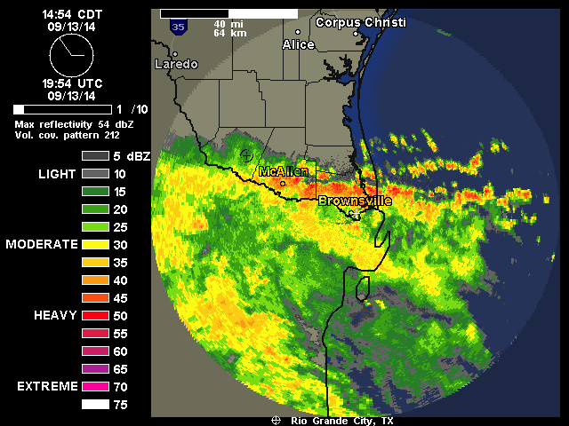
Brownsville is about to get pounded from x-94L.
http://radar.weather.gov/ridge/radar.ph ... o&loop=yes
http://radar.weather.gov/ridge/radar.ph ... o&loop=yes
0 likes
hurricanelonny
-
Rgv20

- S2K Supporter

- Posts: 2466
- Age: 39
- Joined: Wed Jan 05, 2011 5:42 pm
- Location: Edinburg/McAllen Tx
Thanks 94L! 

0 likes
The following post is NOT an official forecast and should not be used as such. It is just the opinion of the poster and may or may not be backed by sound meteorological data. It is NOT endorsed by any professional institution including storm2k.org For Official Information please refer to the NHC and NWS products.
Who is online
Users browsing this forum: No registered users and 18 guests