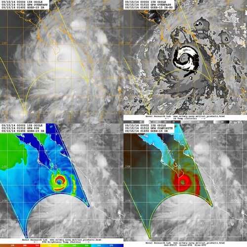
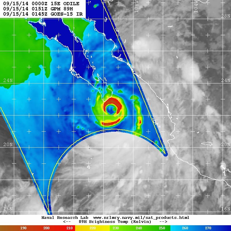
EPAC: ODILE - Remnants

Moderator: S2k Moderators

Message
Author
User avatar
Andrew92
S2K Supporter
S2K Supporter
Posts: 3247
Age: 41
Joined: Mon Jun 16, 2003 12:35 am
Location: Phoenix, Arizona

Re:

#421 Postby Andrew92 » Sun Sep 14, 2014 8:52 pm

RL3AO wrote:Well we've seen what happens to storms when they hit Mexico or Hispaniola. If this starts running up the Baja for any amount of time, it will weaken much quicker than the forecast and models show.


I'm not worried about weakening of the winds. I'm hoping we don't get a repeat of what Norbert did last week.

Last year, Ivo was barely a tropical storm as it approached Baja, and the west side of Phoenix still got hit with some very heavy rain from the remnants of that storm with as I recall some isolated flooding (though the east side, where I live, somehow got spared).

My ideal situation at this point is that this pulls a Jimena from 2009. That was the first storm I remember bringing moisture into Arizona since I moved here in 2007, but we only got a few passing showers from that one since it actually looped back to the southwest as it was dissipating. No flooding to speak of, and in fact made an already nice night even nicer.

-Andrew92
0 likes   

supercane4867
Category 5
Category 5
Posts: 4966
Joined: Wed Nov 14, 2012 10:43 am

Re: EPAC: ODILE - Hurricane

#422 Postby supercane4867 » Sun Sep 14, 2014 8:53 pm

Automated station at SAN LUCAS now observing sustained TS force wind with gusts near 60kt

http://smn.cna.gob.mx/emas/txt/BS03_10M.TXT
0 likes   

User avatar
Ivanhater
Storm2k Moderator
Storm2k Moderator
Posts: 11161
Age: 38
Joined: Fri Jul 01, 2005 8:25 am
Location: Pensacola

Re: Re:

#423 Postby Ivanhater » Sun Sep 14, 2014 8:55 pm

Andrew92 wrote:
RL3AO wrote:Well we've seen what happens to storms when they hit Mexico or Hispaniola. If this starts running up the Baja for any amount of time, it will weaken much quicker than the forecast and models show.


I'm not worried about weakening of the winds. I'm hoping we don't get a repeat of what Norbert did last week.

Last year, Ivo was barely a tropical storm as it approached Baja, and the west side of Phoenix still got hit with some very heavy rain from the remnants of that storm with as I recall some isolated flooding (though the east side, where I live, somehow got spared).

My ideal situation at this point is that this pulls a Jimena from 2009. That was the first storm I remember bringing moisture into Arizona since I moved here in 2007, but we only got a few passing showers from that one since it actually looped back to the southwest as it was dissipating. No flooding to speak of, and in fact made an already nice night even nicer.

-Andrew92


Exactly. my concern is the interaction with the possible cut off low coming in with the left over of Odile. Lots of dynamics here but first off, prayer are with the Cabo area
0 likes   
Michael

User avatar
Yellow Evan
Professional-Met
Professional-Met
Posts: 16143
Age: 27
Joined: Fri Jul 15, 2011 12:48 pm
Location: Henderson, Nevada/Honolulu, HI
Contact:

#424 Postby Yellow Evan » Sun Sep 14, 2014 8:56 pm

Been noticing a W wobble. Could spear Cabo just W, and set us up for a Todos Santos landfall.
0 likes   

User avatar
Yellow Evan
Professional-Met
Professional-Met
Posts: 16143
Age: 27
Joined: Fri Jul 15, 2011 12:48 pm
Location: Henderson, Nevada/Honolulu, HI
Contact:

#425 Postby Yellow Evan » Sun Sep 14, 2014 8:58 pm

UW - CIMSS
ADVANCED DVORAK TECHNIQUE
ADT-Version 8.2.1
Tropical Cyclone Intensity Algorithm

----- Current Analysis -----
Date : 15 SEP 2014 Time : 010000 UTC
Lat : 22:15:44 N Lon : 109:15:48 W


CI# /Pressure/ Vmax
6.4 / 930.3mb/124.6kt


Final T# Adj T# Raw T#
6.2 6.1 6.1

Estimated radius of max. wind based on IR : 12 km

Center Temp : -21.0C Cloud Region Temp : -68.8C

Scene Type : EYE

Positioning Method : SPIRAL ANALYSIS

Ocean Basin : EAST PACIFIC
Dvorak CI > MSLP Conversion Used : ATLANTIC

Tno/CI Rules : Constraint Limits : NO LIMIT
Weakening Flag : ON
Rapid Dissipation Flag : FLAG

C/K/Z MSLP Estimate Inputs :
- Average 34 knot radii : 145km
- Environmental MSLP : 1006mb

Satellite Name : GOES15
Satellite Viewing Angle : 38.9 degrees
0 likes   

supercane4867
Category 5
Category 5
Posts: 4966
Joined: Wed Nov 14, 2012 10:43 am

Re: EPAC: ODILE - Hurricane

#426 Postby supercane4867 » Sun Sep 14, 2014 9:01 pm

Steering currents are highly favorable for a continuous NNW movement

Image
0 likes   

User avatar
AJC3
Admin
Admin
Posts: 3999
Age: 61
Joined: Tue Aug 31, 2004 7:04 pm
Location: Ballston Spa, New York
Contact:

Re:

#427 Postby AJC3 » Sun Sep 14, 2014 9:03 pm

CrazyC83 wrote:Landfall, if anywhere, looks to be on the eastern edge of the southern tip.


I was thinking that up until about 90 minutes ago. Not anymore though. Looks more like a direct smack on Cabo.

Largely a moot point now anyway given the completion of the EWRC/dissipation of the smaller inner EW.
0 likes   

CrazyC83
Professional-Met
Professional-Met
Posts: 34002
Joined: Tue Mar 07, 2006 11:57 pm
Location: Deep South, for the first time!

#428 Postby CrazyC83 » Sun Sep 14, 2014 9:08 pm

From iCyclone: 8 pm. Lights flickering. Front doors of the hotel are gonna go. The sofa won't keep them up. 991 mb.
0 likes   

User avatar
Yellow Evan
Professional-Met
Professional-Met
Posts: 16143
Age: 27
Joined: Fri Jul 15, 2011 12:48 pm
Location: Henderson, Nevada/Honolulu, HI
Contact:

#429 Postby Yellow Evan » Sun Sep 14, 2014 9:11 pm

Who would have thought two and a half days ago we were be talking about a borderline Cat 4 landfall? Once again proves my new adge about how you watch out if a storm is forecast to A) Intensify and B) Pass W of Baja. The track almost always shifts W in these situations.
0 likes   

CrazyC83
Professional-Met
Professional-Met
Posts: 34002
Joined: Tue Mar 07, 2006 11:57 pm
Location: Deep South, for the first time!

#430 Postby CrazyC83 » Sun Sep 14, 2014 9:12 pm

Cabo San Lucas is at 22.9N 109.9W for reference.
0 likes   

User avatar
Yellow Evan
Professional-Met
Professional-Met
Posts: 16143
Age: 27
Joined: Fri Jul 15, 2011 12:48 pm
Location: Henderson, Nevada/Honolulu, HI
Contact:

Re:

#431 Postby Yellow Evan » Sun Sep 14, 2014 9:12 pm

CrazyC83 wrote:Cabo San Lucas is at 22.9N 109.9W for reference.


Looks like iCyclone is in the perfect spot.
0 likes   

Alyono
Professional-Met
Professional-Met
Posts: 6961
Joined: Fri Apr 26, 2013 3:52 pm
Location: Texas Coast

#432 Postby Alyono » Sun Sep 14, 2014 9:21 pm

may go just east of Cabo. It made another northward wobble
0 likes   

User avatar
Yellow Evan
Professional-Met
Professional-Met
Posts: 16143
Age: 27
Joined: Fri Jul 15, 2011 12:48 pm
Location: Henderson, Nevada/Honolulu, HI
Contact:

#433 Postby Yellow Evan » Sun Sep 14, 2014 9:21 pm

UW - CIMSS
ADVANCED DVORAK TECHNIQUE
ADT-Version 8.2.1
Tropical Cyclone Intensity Algorithm

----- Current Analysis -----
Date : 15 SEP 2014 Time : 013000 UTC
Lat : 22:20:44 N Lon : 109:19:46 W


CI# /Pressure/ Vmax
6.4 / 930.2mb/124.6kt


Final T# Adj T# Raw T#
6.1 6.0 6.0

Estimated radius of max. wind based on IR : 11 km

Center Temp : -35.1C Cloud Region Temp : -69.0C

Scene Type : EYE

Positioning Method : SPIRAL ANALYSIS

Ocean Basin : EAST PACIFIC
Dvorak CI > MSLP Conversion Used : ATLANTIC

Tno/CI Rules : Constraint Limits : NO LIMIT
Weakening Flag : ON
Rapid Dissipation Flag : FLAG

C/K/Z MSLP Estimate Inputs :
- Average 34 knot radii : 145km
- Environmental MSLP : 1006mb

Satellite Name : GOES15
Satellite Viewing Angle : 38.9 degrees
0 likes   

User avatar
Yellow Evan
Professional-Met
Professional-Met
Posts: 16143
Age: 27
Joined: Fri Jul 15, 2011 12:48 pm
Location: Henderson, Nevada/Honolulu, HI
Contact:

Re:

#434 Postby Yellow Evan » Sun Sep 14, 2014 9:23 pm

Alyono wrote:may go just east of Cabo. It made another northward wobble


If anything, it is starting to veer NW.
0 likes   

User avatar
NDG
S2K Supporter
S2K Supporter
Posts: 15446
Joined: Sun Jul 09, 2006 10:14 pm
Location: Orlando, FL

Re: EPAC: ODILE - Hurricane

#435 Postby NDG » Sun Sep 14, 2014 9:30 pm

No wonder I can't find much current observations from Baja, theyvarecstarting to get hit now.

Image
0 likes   

User avatar
Yellow Evan
Professional-Met
Professional-Met
Posts: 16143
Age: 27
Joined: Fri Jul 15, 2011 12:48 pm
Location: Henderson, Nevada/Honolulu, HI
Contact:

#436 Postby Yellow Evan » Sun Sep 14, 2014 9:33 pm

Noticing slight N wobble on loops now. Landfall is an hour or so away.
0 likes   

User avatar
Yellow Evan
Professional-Met
Professional-Met
Posts: 16143
Age: 27
Joined: Fri Jul 15, 2011 12:48 pm
Location: Henderson, Nevada/Honolulu, HI
Contact:

Re: EPAC: ODILE - Hurricane

#437 Postby Yellow Evan » Sun Sep 14, 2014 9:33 pm

NDG wrote:No wonder I can't find much current observations from Baja, theyvarecstarting to get hit now.


Power is out there AFAIK.
0 likes   

User avatar
NDG
S2K Supporter
S2K Supporter
Posts: 15446
Joined: Sun Jul 09, 2006 10:14 pm
Location: Orlando, FL

Re: EPAC: ODILE - Hurricane

#438 Postby NDG » Sun Sep 14, 2014 9:35 pm

Image
0 likes   

User avatar
Kingarabian
S2K Supporter
S2K Supporter
Posts: 15980
Joined: Sat Aug 08, 2009 3:06 am
Location: Honolulu, Hawaii

#439 Postby Kingarabian » Sun Sep 14, 2014 9:39 pm

Thankfully it never got the chance to fully complete its ERC.
0 likes   
RIP Kobe Bryant

User avatar
Kingarabian
S2K Supporter
S2K Supporter
Posts: 15980
Joined: Sat Aug 08, 2009 3:06 am
Location: Honolulu, Hawaii

#440 Postby Kingarabian » Sun Sep 14, 2014 9:40 pm

They're getting hit by the nastiest part of the eyewall right now.
0 likes   
RIP Kobe Bryant


Return to “2014”

Who is online

Users browsing this forum: No registered users and 7 guests