First Major cane of 2014 season
BULLETIN
HURRICANE EDOUARD ADVISORY NUMBER 21
NWS NATIONAL HURRICANE CENTER MIAMI FL AL062014
1100 AM AST TUE SEP 16 2014
...EDOUARD BECOMES THE FIRST MAJOR HURRICANE OF THE SEASON...
SUMMARY OF 1100 AM AST...1500 UTC...INFORMATION
-----------------------------------------------
LOCATION...31.1N 57.8W
ABOUT 420 MI...675 KM E OF BERMUDA
ABOUT 1720 MI...2770 KM W OF FAYAL ISLAND IN THE WESTERN AZORES
MAXIMUM SUSTAINED WINDS...115 MPH...185 KM/H
PRESENT MOVEMENT...NNW OR 345 DEGREES AT 13 MPH...20 KM/H
MINIMUM CENTRAL PRESSURE...955 MB...28.20 INCHES
HURRICANE EDOUARD DISCUSSION NUMBER 21
NWS NATIONAL HURRICANE CENTER MIAMI FL AL062014
1100 AM AST TUE SEP 16 2014
Visible satellite images show that Edouard has an impressive
satellite presentation, displaying a well-defined eye within the
central dense overcast. Edouard is upgraded to a major
hurricane based on a subjective Dvorak intensity estimate of 102 kt
from TAFB, an ADT estimate of 107 kt, and a recent SFMR surface
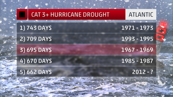
wind of 97 kt in the southwest eyewall. Edouard is the first major
hurricane of the 2014 Atlantic hurricane season, and the
first category 3 or greater hurricane in the basin since Sandy on
October 25, 2012.
Edouard is expected to reach its peak intensity within the next
12-18 hours while it remains in light shear conditions and over warm
waters. A combination of decreasing SSTs and increasing shear
should cause the hurricane to start a steady weakening by late
tomorrow. The intensity guidance is in good agreement, and the
latest NHC forecast is close to the previous NHC prediction and the
intensity consensus. Edouard is expected to become post-tropical by
day 4, but this transition could even occur around day 3 due to
rather cool waters in the cyclone's path.
The initial motion is gradually shifting to the right, now 345/11.
Edouard remains located to the west of the subtropical high and will
turn northward and northeastward into the mid-latitude westerlies
during the next 24-36 hours. An eastward acceleration is expected
by 48 hours, and the cyclone is forecast to turn southeastward and
slow down on days 4 and 5 when it approaches the west side of a
deep-layer low between Portugal and the Azores. The interaction of
the low and the tropical cyclone is causing the model guidance to
become more divergent at long range, with the GFS and the GFDL
models taking the cyclone well north of the Azores. However,
the GFS ensemble is much farther southwest than the deterministic
GFS, and is much more consistent with the previous forecast and the
bulk of the guidance. Thus, I have elected to leave the NHC
prediction virtually unchanged from the previous one, even though
the model consensus is a fair distance to the northeast of the new
official track at long range.
FORECAST POSITIONS AND MAX WINDS
INIT 16/1500Z 31.1N 57.8W 100 KT 115 MPH
12H 17/0000Z 33.0N 57.1W 100 KT 115 MPH
24H 17/1200Z 35.7N 54.6W 95 KT 110 MPH
36H 18/0000Z 38.4N 50.6W 85 KT 100 MPH
48H 18/1200Z 40.3N 45.7W 75 KT 85 MPH
72H 19/1200Z 41.0N 38.5W 55 KT 65 MPH
96H 20/1200Z 40.0N 35.0W 40 KT 45 MPH...POST-TROPICAL
120H 21/1200Z 38.0N 32.0W 30 KT 35 MPH...POST-TROPICAL
$$
Forecaster Blake
ATL: EDOUARD - Post-Tropical - Discussion
Moderator: S2k Moderators
-
cycloneye

- Admin

- Posts: 149508
- Age: 69
- Joined: Thu Oct 10, 2002 10:54 am
- Location: San Juan, Puerto Rico
Re: ATL: EDOUARD - Hurricane - Discussion
0 likes
Visit the Caribbean-Central America Weather Thread where you can find at first post web cams,radars
and observations from Caribbean basin members Click Here
and observations from Caribbean basin members Click Here

-
wxman57

- Moderator-Pro Met

- Posts: 23175
- Age: 68
- Joined: Sat Jun 21, 2003 8:06 pm
- Location: Houston, TX (southwest)
Re: ATL: EDOUARD - Hurricane - Discussion
The last Cat 3 or greater in the Atlantic Basin was Sandy south of Cuba in October of 2012.
0 likes
-
somethingfunny

- ChatStaff

- Posts: 3926
- Age: 37
- Joined: Thu May 31, 2007 10:30 pm
- Location: McKinney, Texas
Re: ATL: EDOUARD - Hurricane - Discussion
wxman57 wrote:The last Cat 3 or greater in the Atlantic Basin was Sandy south of Cuba in October of 2012.
Time to update this and close up the loose end.
Last edited by somethingfunny on Tue Sep 16, 2014 10:10 am, edited 1 time in total.
0 likes
I am not a meteorologist, and any posts made by me are not official forecasts or to be interpreted as being intelligent. These posts are just my opinions and are probably silly opinions.
-
SeGaBob


-
Chris_in_Tampa
- Category 5

- Posts: 5101
- Age: 42
- Joined: Thu Jun 21, 2007 11:06 pm
- Location: Tampa, Florida, USA
- Contact:

-
SapphireSea
- Category 1

- Posts: 430
- Joined: Wed Aug 24, 2005 12:13 pm
- Location: Miami, FL
Re: ATL: EDOUARD - Hurricane - Discussion
All the instability has been present above 25N these past two years. Good to see a harmless major come out of this though! I wonder if this will continue to be the common pattern. I figure as soon as this ENSO ends, instability should return.
Edouard really got the shape of Andrew in the last 24 hours, very impressive. May still get to near Cat 4 perhaps?
Edouard really got the shape of Andrew in the last 24 hours, very impressive. May still get to near Cat 4 perhaps?
0 likes
Forecast Disclaimer:
Don't be stupid. Make your own informed decisions.
Don't be stupid. Make your own informed decisions.
-
Chris_in_Tampa
- Category 5
- Posts: 5101
- Age: 42
- Joined: Thu Jun 21, 2007 11:06 pm
- Location: Tampa, Florida, USA
- Contact:

-
supercane4867
- Category 5
- Posts: 4966
- Joined: Wed Nov 14, 2012 10:43 am
Re: ATL: EDOUARD - Hurricane - Discussion
At this point it's very unlikely that Edouard can strengthen further to attain a T6.0 as waters ahead becoming progressively cooler
0 likes
-
TheStormExpert
It looks liked it peaked as its satellite presentation is becoming increasingly ragged. Hey, at least we squeezed out a major! Can't believe how challenging it has been for the Atlantic to produce Cat.3+ hurricanes over the past several years. I also predict that this will be the first and only major hurricane of this season.
0 likes
-
tolakram
- Admin
- Posts: 20186
- Age: 62
- Joined: Sun Aug 27, 2006 8:23 pm
- Location: Florence, KY (name is Mark)
Re: ATL: EDOUARD - Hurricane - Discussion
0 likes
M a r k
- - - - -
Join us in chat: Storm2K Chatroom Invite. Android and IOS apps also available.
The posts in this forum are NOT official forecasts and should not be used as such. Posts are NOT endorsed by any professional institution or STORM2K.org. For official information and forecasts, please refer to NHC and NWS products.
-
tolakram
- Admin
- Posts: 20186
- Age: 62
- Joined: Sun Aug 27, 2006 8:23 pm
- Location: Florence, KY (name is Mark)
Re: ATL: EDOUARD - Hurricane - Discussion
Looking at the RAMSDIS floater it appears shear from the south west has markedly increased over the past few hours.
http://rammb.cira.colostate.edu/products/tc_realtime/loop.asp?product=1kmsrvis&storm_identifier=AL062014&starting_image=2014AL06_1KMSRVIS_201409161145.GIF
http://rammb.cira.colostate.edu/products/tc_realtime/loop.asp?product=1kmsrvis&storm_identifier=AL062014&starting_image=2014AL06_1KMSRVIS_201409161145.GIF
0 likes
M a r k
- - - - -
Join us in chat: Storm2K Chatroom Invite. Android and IOS apps also available.
The posts in this forum are NOT official forecasts and should not be used as such. Posts are NOT endorsed by any professional institution or STORM2K.org. For official information and forecasts, please refer to NHC and NWS products.
- - - - -
Join us in chat: Storm2K Chatroom Invite. Android and IOS apps also available.
The posts in this forum are NOT official forecasts and should not be used as such. Posts are NOT endorsed by any professional institution or STORM2K.org. For official information and forecasts, please refer to NHC and NWS products.
-
tolakram
- Admin
- Posts: 20186
- Age: 62
- Joined: Sun Aug 27, 2006 8:23 pm
- Location: Florence, KY (name is Mark)
Re:
Yellow Evan wrote:I'm calling it. Not only will Edouard will become the season's first major, it will become a Cat 4.
Got the first part right, now can it go for cat 4 before hitting cooler waters in a day or so?
0 likes
M a r k
- - - - -
Join us in chat: Storm2K Chatroom Invite. Android and IOS apps also available.
The posts in this forum are NOT official forecasts and should not be used as such. Posts are NOT endorsed by any professional institution or STORM2K.org. For official information and forecasts, please refer to NHC and NWS products.
- - - - -
Join us in chat: Storm2K Chatroom Invite. Android and IOS apps also available.
The posts in this forum are NOT official forecasts and should not be used as such. Posts are NOT endorsed by any professional institution or STORM2K.org. For official information and forecasts, please refer to NHC and NWS products.
-
SeGaBob
Re: ATL: EDOUARD - Hurricane - Discussion
Hammy wrote:AL, 06, 2014091606, , BEST, 0, 296N, 572W, 95, 963, HU
Looks like no upgrade at 5am either, and the storm looks like it may be beginning an ERC (after which point it will be over steadily cooling waters) so I think Edouard missed it's opportunity to become a major hurricane. Euro no longer shows any further strengthening either.
Are you trolling? I've never seen anyone downplay a storm so much in my life.
Beautiful storm. So great to finally see a major in the Atlantic.
0 likes

Re: ATL: EDOUARD - Hurricane - Discussion
Time_Zone wrote:Hammy wrote:AL, 06, 2014091606, , BEST, 0, 296N, 572W, 95, 963, HU
Looks like no upgrade at 5am either, and the storm looks like it may be beginning an ERC (after which point it will be over steadily cooling waters) so I think Edouard missed it's opportunity to become a major hurricane. Euro no longer shows any further strengthening either.
Are you trolling? I've never seen anyone downplay a storm so much in my life.
Beautiful storm. So great to finally see a major in the Atlantic.
Gordon 2012 was coming to mind increasingly, it looked much better on satellite yesterday afternoon than it did overnight, and with two of three agencies showing Cat 3 with no upgrade, it appeared they would dither again until it began weakening (I personally believe Gordon reached 100kts and have it listed as such with notes regarding the satellite estimates)
The fact that it looked better before the plane reached the eye, and that the pressure has is up with each pass, indicates that it may have in fact been stronger earlier and was indeed weakening already.
edit: as an aside, BT is already down to 95kts again, so this would likely not have been upgraded without recon.
0 likes
The above post is not official and should not be used as such. It is the opinion of the poster and may or may not be backed by sound meteorological data. It is not endorsed by any professional institution or storm2k.org. For official information, please refer to the NHC and NWS products.
-
somethingfunny
- ChatStaff
- Posts: 3926
- Age: 37
- Joined: Thu May 31, 2007 10:30 pm
- Location: McKinney, Texas
Re: ATL: EDOUARD - Hurricane - Discussion
Did Gordon ever have recon? This year being so slow has provided alot of overflow for the hurricane hunter budget and that's probably given Edouard a leg up.
0 likes
I am not a meteorologist, and any posts made by me are not official forecasts or to be interpreted as being intelligent. These posts are just my opinions and are probably silly opinions.
Who is online
Users browsing this forum: No registered users and 30 guests