BULLETIN
TROPICAL STORM ODILE ADVISORY NUMBER 30
NWS NATIONAL HURRICANE CENTER MIAMI FL EP152014
800 AM PDT WED SEP 17 2014
...ODILE WEAKENING WHILE IT MOVES SLOWLY NORTHEASTWARD ACROSS THE
NORTHERN GULF OF CALIFORNIA...
...HEAVY RAINFALL EXPECTED TO CONTINUE OVER PORTIONS OF NORTHWESTERN
MEXICO AND THE SOUTHWESTERN UNITED STATES...
SUMMARY OF 800 AM PDT...1500 UTC...INFORMATION
----------------------------------------------
LOCATION...30.6N 113.3W
ABOUT 50 MI...85 KM SSE OF PUERTO PENASCO MEXICO
MAXIMUM SUSTAINED WINDS...40 MPH...65 KM/H
PRESENT MOVEMENT...NE OR 35 DEGREES AT 6 MPH...9 KM/H
MINIMUM CENTRAL PRESSURE...997 MB...29.44 INCHES
TROPICAL STORM ODILE DISCUSSION NUMBER 30
NWS NATIONAL HURRICANE CENTER MIAMI FL EP152014
800 AM PDT WED SEP 17 2014
First-light visible and microwave satellite imagery, along with NOAA
Doppler radar data from Yuma and Tucson, suggest that the low-level
center of Odile is still over the northern Gulf of California while
the mid- and upper-level circulations are displaced well to the
northeast over northwestern Mexico. As a result, satellite intensity
estimates have been rapidly decreasing, and the initial intensity
estimate has been lowered to 35 kt. The combination of the low-level
blocking effect of the mountains of northwestern Mexico, plus
increasing southwesterly vertical wind shear and abundant dry air
ahead of the aforementioned trough noted in water vapor imagery, are
expected to induce continued weakening, and Odile could potentially
degenerate into a remnant low or dissipate as early as this
afternoon.
The initial motion estimate is now 035/05 kt. A strong ridge
extending westward over Mexico, in conjunction with an approaching
mid-/upper-level trough to the west of Baja California, should keep
Odile moving toward the northeast over the next day or so. The
center of Odile or its remnants is expected to move slowly across
the northern Gulf of California today, and move into northwestern
Mexico and southern Arizona tonight and Thursday. The new forecast
track is just an update of the previous track and lies near the
consensus model TVCE. Alternatively, the low-level circulation could
continue to separate from the circulation aloft and remain behind
over the Gulf of California.
The primary threat with Odile and its remnants will be heavy
rainfall due to the large plume of deep tropical moisture that will
continue to spread across northwestern Mexico and the southwestern
United States over the next couple of days. These heavy rains will
likely cause flooding and mudslides, especially in mountainous
areas. Please see information from your local weather office for
more details.
FORECAST POSITIONS AND MAX WINDS
INIT 17/1500Z 30.6N 113.3W 35 KT 40 MPH
12H 18/0000Z 31.5N 112.4W 30 KT 35 MPH...INLAND
24H 18/1200Z 32.7N 111.3W 20 KT 25 MPH...POST-TROP/REMNT LOW
36H 19/0000Z...DISSIPATED
$$
Forecaster Stewart
EPAC: ODILE - Remnants
Moderator: S2k Moderators
-
cycloneye

- Admin

- Posts: 149550
- Age: 69
- Joined: Thu Oct 10, 2002 10:54 am
- Location: San Juan, Puerto Rico
Re: EPAC: ODILE - Tropical Storm
0 likes
Visit the Caribbean-Central America Weather Thread where you can find at first post web cams,radars
and observations from Caribbean basin members Click Here
and observations from Caribbean basin members Click Here
-
somethingfunny

- ChatStaff

- Posts: 3926
- Age: 37
- Joined: Thu May 31, 2007 10:30 pm
- Location: McKinney, Texas
Re: EPAC: ODILE - Tropical Storm
It looks like Phoenix will escape the flooding this time (this isn't a certainty yet by the way), but eastern Arizona (including Tucson) and the entirety of New Mexico are at significant risk.


0 likes
I am not a meteorologist, and any posts made by me are not official forecasts or to be interpreted as being intelligent. These posts are just my opinions and are probably silly opinions.
-
cycloneye
- Admin
- Posts: 149550
- Age: 69
- Joined: Thu Oct 10, 2002 10:54 am
- Location: San Juan, Puerto Rico
Re: EPAC: ODILE - Tropical Depression
BULLETIN
TROPICAL DEPRESSION ODILE INTERMEDIATE ADVISORY NUMBER 30A
NWS NATIONAL HURRICANE CENTER MIAMI FL EP152014
1100 AM PDT WED SEP 17 2014
...ODILE WEAKENS TO A DEPRESSION OVER NORTHWESTERN MEXICO...
...HEAVY RAINFALL TO CONTINUE ACROSS PORTIONS OF NORTHWESTERN MEXICO
AND THE SOUTHWESTERN UNITED STATES...
SUMMARY OF 1100 AM PDT...1800 UTC...INFORMATION
-----------------------------------------------
LOCATION...30.8N 113.0W
ABOUT 35 MI...55 KM W OF CABORCA MEXICO
ABOUT 150 MI...245 KM SW OF TUCSON ARIZONA
MAXIMUM SUSTAINED WINDS...35 MPH...55 KM/H
PRESENT MOVEMENT...NE OR 40 DEGREES AT 6 MPH...9 KM/H
MINIMUM CENTRAL PRESSURE...1004 MB...29.65 INCHES
0 likes
Visit the Caribbean-Central America Weather Thread where you can find at first post web cams,radars
and observations from Caribbean basin members Click Here
and observations from Caribbean basin members Click Here
-
cycloneye
- Admin
- Posts: 149550
- Age: 69
- Joined: Thu Oct 10, 2002 10:54 am
- Location: San Juan, Puerto Rico
Re: EPAC: ODILE - Remnants
Last advisory.
BULLETIN
REMNANTS OF ODILE ADVISORY NUMBER 31
NWS NATIONAL HURRICANE CENTER MIAMI FL EP152014
200 PM PDT WED SEP 17 2014
...ODILE DISSIPATES OVER NORTHWESTERN MEXICO...
...REMNANTS OF ODILE EXPECTED TO PRODUCE HEAVY RAINFALL ACROSS
PORTIONS OF NORTHWESTERN MEXICO AND THE SOUTHWESTERN UNITED
STATES...
SUMMARY OF 200 PM PDT...2100 UTC...INFORMATION
----------------------------------------------
LOCATION...31.1N 112.7W
ABOUT 20 MI...35 KM WNW OF CABORCA MEXICO
ABOUT 125 MI...200 KM WSW OF TUCSON ARIZONA
MAXIMUM SUSTAINED WINDS...30 MPH...45 KM/H
PRESENT MOVEMENT...NE OR 45 DEGREES AT 7 MPH...11 KM/H
MINIMUM CENTRAL PRESSURE...1004 MB...29.65 INCHES
REMNANTS OF ODILE DISCUSSION NUMBER 31
NWS NATIONAL HURRICANE CENTER MIAMI FL EP152014
200 PM PDT WED SEP 17 2014
Satellite and surface observations indicate that the low-level
circulation of Odile is becoming elongated and losing definition
over extreme northwestern mainland Mexico, with a number of small
cloud swirls rotating within a broad cyclonic envelope. In addition,
the remaining deep convection is becoming increasingly displaced
from the decaying surface center. Based on these observations,
Odile is no longer considered a tropical cyclone and this will be
the last advisory issued by the National Hurricane Center. Because
the remnants of Odile continue to represent a significant rainfall
threat, the NOAA Weather Prediction Center will issue public
advisories while that threat exists, beginning at 8 p.m. PDT under
AWIPS header TCPEP5 and WMO header WTPZ35 KWNH.
The initial motion estimate is now 045/06 kt. The remnants of
Odile should continue to move toward the northeast or east-northeast
across extreme northwestern Mexico tonight, and across southeastern
Arizona on Thursday ahead of an eastward-moving mid-latitude trough
currently approaching western Baja California.
Heavy rainfall and flooding associated with the remnants of Odile
will continue to be a significant threat across northwestern Mexico
and the southwestern United States during the next couple of days.
These heavy rains will likely cause flooding and mudslides,
especially in mountainous areas. For future details, please see
information from your local weather office and the NOAA Weather
Prediction Center.
FORECAST POSITIONS AND MAX WINDS
INIT 17/2100Z 31.1N 112.7W 25 KT 30 MPH...REMNANTS INLAND
12H 18/0600Z 31.9N 111.8W 20 KT 25 MPH...REMNANTS INLAND
24H 18/1800Z...DISSIPATED INLAND
$$
Forecaster Stewart
0 likes
Visit the Caribbean-Central America Weather Thread where you can find at first post web cams,radars
and observations from Caribbean basin members Click Here
and observations from Caribbean basin members Click Here
-
Steve820

- Tropical Storm

- Posts: 188
- Age: 26
- Joined: Sat May 17, 2014 8:04 pm
- Location: Southern California
- Contact:
It could cause some floods in Arizona but I don't think it'll be so bad for those guys. I wish it would've streamed into SoCal instead so we can get urgently-needed rain!
0 likes
Hurricanes are an amazing natural phenomena. While many are spiraling pits of evil that kill people or cause devastation, some are tame and stay clear of land.
I wish for you to
I wish for you to
-
Andrew92

- S2K Supporter

- Posts: 3247
- Age: 42
- Joined: Mon Jun 16, 2003 12:35 am
- Location: Phoenix, Arizona
No flooding to speak of in the Phoenix area. It did rain heavily for a little bit during my lunch but it let up quickly and it hasn't rained since. There are some puddles, it has been humid, and the mosquitoes are very bad, but that's probably going to be the worst if it here.
Let me just say that I am very thankful that it appears Phoenix has dodged a bullet. Prayers going to those who have suffered greatly from this storm.
-Andrew92
Let me just say that I am very thankful that it appears Phoenix has dodged a bullet. Prayers going to those who have suffered greatly from this storm.
-Andrew92
0 likes
-
CrazyC83
- Professional-Met

- Posts: 34315
- Joined: Tue Mar 07, 2006 11:57 pm
- Location: Deep South, for the first time!
Re: EPAC: ODILE - Remnants
Personal Forecast Disclaimer:
The posts in this forum are NOT official forecast and should not be used as such. They are just the opinion of the poster and may or may not be backed by sound meteorological data. They are NOT endorsed by any professional institution or storm2k.org. For official information, please refer to the NHC and NWS products.
NOT OFFICIAL, but this is how I would set the best track:
20140910, 0000, , TD, 14.0N, 101.8W, 25, 1005,
20140910, 0600, , TD, 14.3N, 102.4W, 30, 1004,
20140910, 1200, , TS, 14.8N, 102.8W, 35, 1002,
20140910, 1800, , TS, 15.2N, 103.1W, 35, 1001,
20140911, 0000, , TS, 15.4N, 103.4W, 40, 1000,
20140911, 0600, , TS, 15.4N, 103.8W, 45, 997,
20140911, 1200, , TS, 15.4N, 104.1W, 45, 996,
20140911, 1800, , TS, 15.3N, 104.4W, 45, 996,
20140912, 0000, , TS, 15.4N, 104.6W, 50, 993,
20140912, 0600, , TS, 15.5N, 104.6W, 50, 991,
20140912, 1200, , TS, 15.6N, 104.7W, 50, 990,
20140912, 1800, , TS, 15.6N, 104.8W, 55, 987,
20140913, 0000, , TS, 15.9N, 105.1W, 60, 984,
20140913, 0600, , HU, 16.1N, 105.5W, 65, 981,
20140913, 1200, , HU, 16.1N, 105.5W, 70, 973,
20140913, 1800, , HU, 16.6N, 106.0W, 80, 964,
20140914, 0000, , HU, 17.4N, 106.2W, 95, 946,
20140914, 0600, , HU, 18.5N, 106.9W, 110, 935,
20140914, 1200, , HU, 19.4N, 107.7W, 115, 930, Maximum Wind
20140914, 1800, , HU, 20.5N, 108.5W, 110, 924,
20140914, 2000, P, HU, 21.1N, 108.7W, 110, 922, Minimum Pressure
20140915, 0000, , HU, 22.0N, 109.3W, 110, 926,
20140915, 0445, L, HU, 22.9N, 109.9W, 105, 934, Landfall – Cabo San Lucas
20140915, 0600, , HU, 23.2N, 110.1W, 100, 938,
20140915, 1100, L, HU, 24.0N, 110.9W, 85, 948, Landfall – NW of Agua Fresca
20140915, 1200, , HU, 24.2N, 111.0W, 85, 950,
20140915, 1800, , HU, 25.1N, 111.5W, 70, 967,
20140916, 0000, , TS, 26.1N, 112.0W, 55, 982,
20140916, 0600, , TS, 27.0N, 112.5W, 50, 987,
20140916, 1200, , TS, 28.0N, 113.1W, 50, 989,
20140916, 1800, , TS, 28.8N, 113.5W, 45, 991,
20140917, 0000, L, TS, 29.4N, 113.6W, 45, 993, Landfall – Isla Angel de la Guarda
20140917, 0600, , TS, 29.9N, 113.6W, 45, 994,
20140917, 1200, , TS, 30.4N, 113.4W, 40, 996,
20140917, 1500, S, LO, 30.6N, 113.2W, 35, 998,
20140917, 1600, L, LO, 30.8N, 113.1W, 35, 999, Landfall – near Jaguay, Sonora (remnant low)
20140917, 1800, , LO, 30.9N, 112.9W, 35, 1000,
20140918, 0000, , LO, 31.2N, 111.9W, 30, 1002,
0 likes

Re: EPAC: ODILE - Remnants
Odile has been pretty bad for Baja California, I have not found reports of deaths fortunately but the damages are extensive:
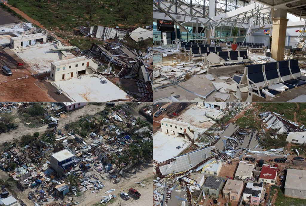
0 likes
-
somethingfunny
- ChatStaff
- Posts: 3926
- Age: 37
- Joined: Thu May 31, 2007 10:30 pm
- Location: McKinney, Texas
Re: EPAC: ODILE - Remnants
The situation in Baja California Sur sounds dire right now.
http://sanfrancisco.cbslocal.com/2014/0 ... ater-food/
http://sanfrancisco.cbslocal.com/2014/0 ... ater-food/
0 likes
I am not a meteorologist, and any posts made by me are not official forecasts or to be interpreted as being intelligent. These posts are just my opinions and are probably silly opinions.
-
euro6208
Re: EPAC: ODILE - Remnants
somethingfunny wrote:The situation in Baja California Sur sounds dire right now.
http://sanfrancisco.cbslocal.com/2014/0 ... ater-food/
Interesting that this is getting more attention as a passing rain cloud in the SW U.S than the destruction in Baja from reading and watching many media/forums...
0 likes
-
galaxy401

- Category 5

- Posts: 2446
- Age: 30
- Joined: Sat Aug 25, 2012 9:04 pm
- Location: Casa Grande, Arizona
Re: EPAC: ODILE - Remnants
euro6208 wrote:somethingfunny wrote:The situation in Baja California Sur sounds dire right now.
http://sanfrancisco.cbslocal.com/2014/0 ... ater-food/
Interesting that this is getting more attention as a passing rain cloud in the SW U.S than the destruction in Baja from reading and watching many media/forums...Anything that affects the U.S seems more important...
You need to remember is that the southwest is getting record rainfalls that they aren't used to (although it sounds like it didn't do that much damage there).
0 likes
Got my eyes on moving right into Hurricane Alley: Florida.
Who is online
Users browsing this forum: No registered users and 9 guests