Texas Fall-2014

U.S. & Caribbean Weather Discussions and Severe Weather Events

Moderator: S2k Moderators

Forum rules

The posts in this forum are NOT official forecast and should not be used as such. They are just the opinion of the poster and may or may not be backed by sound meteorological data. They are NOT endorsed by any professional institution or STORM2K.

Help Support Storm2K
Message
Author
User avatar
Texas Snowman
Storm2k Moderator
Storm2k Moderator
Posts: 6179
Joined: Fri Jan 25, 2008 11:29 am
Location: Denison, Texas

Re:

#381 Postby Texas Snowman » Thu Sep 25, 2014 3:19 pm

dhweather wrote:NWSFortWorth: DFW has had 0.06" of rain this month. Record for driest September ever is 0.09" in '84. No rain is in 7 day forecast. #dfwwx #txwx


Meanwhile, just 66 miles to the north of DFW Airport, it isn't the driest September on record...by far.

In fact, Sherman has recorded 2.93 inches of rain this month. Other places in Grayson County have had even more rainfall this month. My father-in-law's farm is one of them - his third-cutting hay crop looks to have grown nearly a foot since earlier in the month.

Some places in Texas are unusually dry this month, but many others are certainly not. Hopefully even the dry doughnut holes in the rainfall map will get some more good rains this fall and winter.
0 likes   
The above post and any post by Texas Snowman is NOT an official forecast and should not be used as such. It is just the opinion of the poster and may or may not be backed by sound meteorological data. It is NOT endorsed by any professional institution including storm2k.org. For official information, please refer to NWS products.

User avatar
TeamPlayersBlue
Category 5
Category 5
Posts: 3445
Joined: Tue Feb 02, 2010 1:44 am
Location: Denver/Applewood, CO

#382 Postby TeamPlayersBlue » Thu Sep 25, 2014 9:58 pm

Nice looking cold front on the 18z. Looks like the air comes from North of Alaska and is in the NW territories in 5 days, 1032 HP in the plains at 252. Something to look forward to. (Possibly)
0 likes   
Personal Forecast Disclaimer:
The posts in this forum are NOT official forecast and should not be used as such. They are just the opinion of the poster and may or may not be backed by sound meteorological data. They are NOT endorsed by any professional institution or storm2k.org. For official information, please refer to the NHC and NWS products.

User avatar
TheProfessor
Professional-Met
Professional-Met
Posts: 3506
Age: 28
Joined: Tue Dec 03, 2013 10:56 am
Location: Wichita, Kansas

#383 Postby TheProfessor » Thu Sep 25, 2014 11:56 pm

:uarrow: It also brings some nice rain for north Texas with it too, hope that run pans out.
0 likes   
An alumnus of The Ohio State University.

Your local National Weather Service office is your best source for weather information.

User avatar
ravyrn
S2K Supporter
S2K Supporter
Posts: 1000
Age: 42
Joined: Sun Aug 31, 2008 5:10 am
Location: Alderbranch, TX

Re: Texas Fall-2014

#384 Postby ravyrn » Fri Sep 26, 2014 2:17 am

horselattitudesfarm wrote::wink:
ravyrn wrote:When plane entrails stay in the sky you know it's cool weather!


I hope you mean 'Contrails' and not 'entrails' or else I'm running inside and hiding. :wink:


Noted! LOL!
0 likes   

User avatar
Rgv20
S2K Supporter
S2K Supporter
Posts: 2466
Age: 38
Joined: Wed Jan 05, 2011 5:42 pm
Location: Edinburg/McAllen Tx

#385 Postby Rgv20 » Fri Sep 26, 2014 5:53 pm

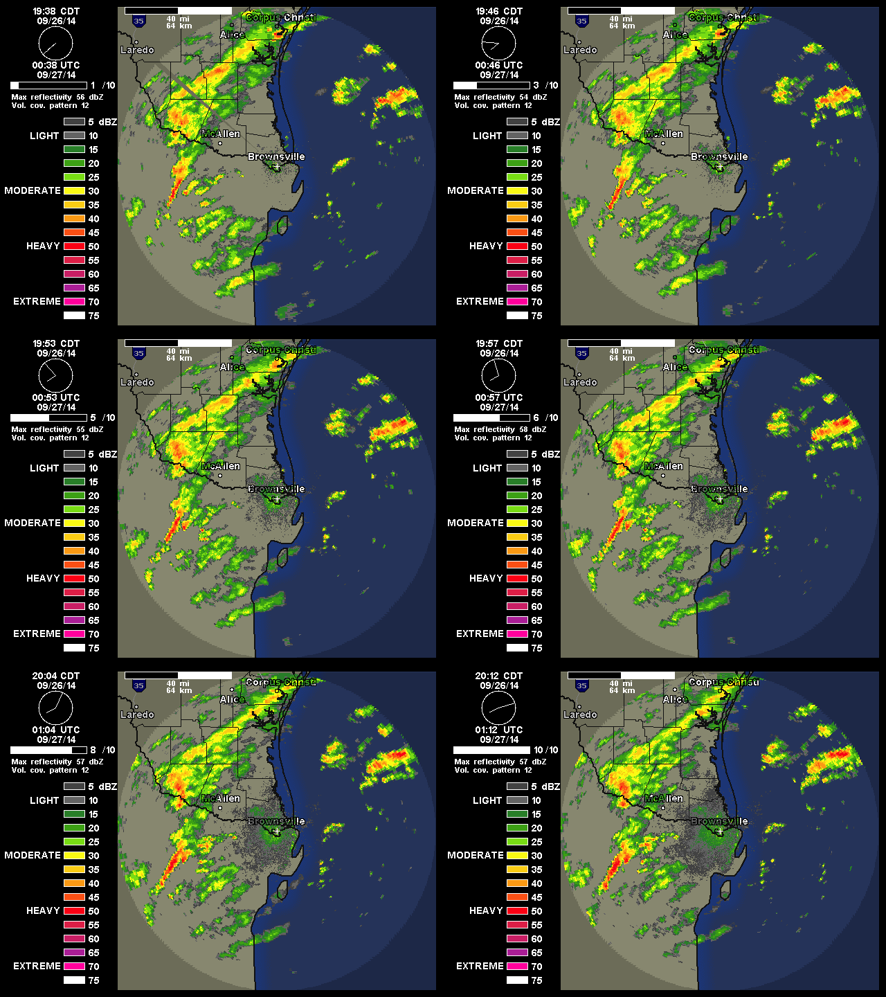
Its been raining cats and dogs for a while now!

FLASH FLOOD STATEMENT
NATIONAL WEATHER SERVICE BROWNSVILLE TX
549 PM CDT FRI SEP 26 2014

TXC427-270000-
/O.CON.KBRO.FF.W.0013.000000T0000Z-140927T0000Z/
/00000.0.ER.000000T0000Z.000000T0000Z.000000T0000Z.OO/
STARR TX-
549 PM CDT FRI SEP 26 2014

...FLASH FLOOD WARNING REMAINS IN EFFECT FOR CENTRAL STARR COUNTY
UNTIL 700 PM CDT...

AT 546 PM CDT...LOCAL LAW ENFORCEMENT OFFICIALS REPORTED STREET
FLOODING WAS OCCURRING IN RIO GRANDE CITY. RADAR CONTINUES TO
INDICATE HEAVY RAINFALL FALLING IN RIO GRANDE CITY...WITH MODERATE
TO HEAVY RAINFALL OCCURRING IN CENTRAL STARR COUNTY WHERE AS MUCH AS
FOUR TO NEARLY FIVE INCHES OF RAIN HAS FALLEN SINCE 400 PM. RAINFALL
IS EXPECTED TO CONTINUE THROUGH AT LEAST 630 PM AND FLOODING WILL
WORSEN.

THE LOS OLMOS CREEK...RUNNING THROUGH THE EASTERN HALF OF THE CITY
IS EXPECTED TO LEAVE ITS BANKS AND THREATEN PROPERTY AND POSSIBLY
CROSS HIGHWAY 755 AND HIGHWAY 83.

LOCATIONS AFFECTED INCLUDE...

PRECAUTIONARY/PREPAREDNESS ACTIONS...

THIS IS A POTENTIALLY DANGEROUS SITUATION. THOSE ALONG THE LOS OLMOS
CREEK SHOULD BE PREPARED TO MOVE TO HIGHER GROUND. TRAVELERS IN THE
AREA SHOULD BE VERY ALERT TO THE POSSIBILITY OF WATER COVERING
STREETS AND HIGHWAYS.

LOW WATER CROSSINGS ARE POTENTIALLY DANGEROUS IN HEAVY RAIN. DO NOT
ATTEMPT TO TRAVEL ACROSS FLOODED ROADS. FIND ALTERNATE ROUTES. IT
ONLY TAKES A FEW INCHES OF SWIFTLY FLOWING WATER TO CARRY VEHICLES
AWAY.

DON`T BECOME A STATISTIC. TURN AROUND...DON`T DROWN!

&&

LAT...LON 2657 9883 2662 9875 2655 9871 2649 9877
2642 9879 2640 9880 2635 9879 2635 9880
2637 9881 2643 9884

$$

JGG
0 likes   
The following post is NOT an official forecast and should not be used as such. It is just the opinion of the poster and may or may not be backed by sound meteorological data. It is NOT endorsed by any professional institution including storm2k.org For Official Information please refer to the NHC and NWS products.

User avatar
South Texas Storms
Professional-Met
Professional-Met
Posts: 4226
Joined: Thu Jun 24, 2010 12:28 am
Location: Houston, TX

Re: Texas Fall-2014

#386 Postby South Texas Storms » Fri Sep 26, 2014 6:21 pm

:uarrow: Nice Rgv!

Moderate rainfall is slowly moving across the Hill Country, San Antonio, and surrounding areas. Rain will likely continue through this evening.

Image
0 likes   

User avatar
gboudx
S2K Supporter
S2K Supporter
Posts: 4080
Joined: Thu Sep 04, 2003 1:39 pm
Location: Rockwall, Tx but from Harvey, La

#387 Postby gboudx » Fri Sep 26, 2014 7:32 pm

Here's what I miss from Steve McCauley not being on WFAA anymore. The guy was never scared to show something long-range.

I am cautiously optimistic to say that the long-range data continue to suggest a significant rain is coming to north Texas by late next week. A storm system - currently just west of the Aleutian Islands - will let loose a piece of its energy on its south side by next Monday which will drop into the southern Gulf of Alaska. There, the math suggests it should undergo rapid intensification and dive SE into California. From there it shoots east into north Texas by next Thursday.

This system should erode the strong cap that will be in place over north Texas and allow showers and storms to fire along a cold front that will be moving in from the west at the same time.

Since this storm system has not yet formed, and since it is still a week away, there are obviously still some uncertainty as to the exact timing and its ultimate strength. But we will be watching for that piece of energy to break off by early next week. Keep your eyes on the Gulf (of Alaska) !
0 likes   

User avatar
Rgv20
S2K Supporter
S2K Supporter
Posts: 2466
Age: 38
Joined: Wed Jan 05, 2011 5:42 pm
Location: Edinburg/McAllen Tx

#388 Postby Rgv20 » Fri Sep 26, 2014 8:19 pm

Wow the Rain just picked up again!

Image
0 likes   
The following post is NOT an official forecast and should not be used as such. It is just the opinion of the poster and may or may not be backed by sound meteorological data. It is NOT endorsed by any professional institution including storm2k.org For Official Information please refer to the NHC and NWS products.

justinggibbs
Tropical Wave
Tropical Wave
Posts: 7
Joined: Fri Oct 12, 2012 3:56 pm
Location: Brownsville, TX

Re:

#389 Postby justinggibbs » Fri Sep 26, 2014 8:57 pm

Rgv20 wrote:Wow the Rain just picked up again!

Do you know if there is much flooding going on there in town? Almost has to be.
0 likes   
This post is NOT AN OFFICIAL FORECAST and should not be used as such. It is just the opinion of the poster and may or may not be backed by sound meteorological data. It is NOT endorsed by any professional institution including storm2k.org. For Official Information please refer to the NHC and NWS products. Opinions my own and not those of my employer.

User avatar
Rgv20
S2K Supporter
S2K Supporter
Posts: 2466
Age: 38
Joined: Wed Jan 05, 2011 5:42 pm
Location: Edinburg/McAllen Tx

#390 Postby Rgv20 » Fri Sep 26, 2014 9:55 pm

:uarrow: Some serious wording out of the NWS.....I don't know anyone from Las Lomas Neighborhood but it sounds like a serious situation for those folks :(

FLASH FLOOD STATEMENT
NATIONAL WEATHER SERVICE BROWNSVILLE TX
935 PM CDT FRI SEP 26 2014

TXC427-270330-
/O.CON.KBRO.FF.W.0014.000000T0000Z-140927T0330Z/
/00000.0.ER.000000T0000Z.000000T0000Z.000000T0000Z.OO/
STARR TX-
935 PM CDT FRI SEP 26 2014

...FLASH FLOOD WARNING REMAINS IN EFFECT FOR CENTRAL STARR COUNTY
UNTIL 1030 PM CDT...

THIS IS A PARTICULARLY DANGEROUS SITUATION FOR THE LAS LOMAS
NEIGHBORHOOD.


AT 933 PM CDT...EMERGENCY MANAGEMENT REPORTED THE LOS OLMOS CREEK
HAS RISEN TWO TO THREE FEET ABOVE ITS BANKS IN LAS LOMAS AND THE
ENTIRE NEIGHBORHOOD IS FLOODED WITH WATER ENTERING HOMES. HEAVY
RAINFALL CONTINUES IN THE NEIGHBORHOOD WITH MODERATE RAINFALL TO THE
NORTH CONTINUING TO FALL ONTO THE LOS OLMOS CREEK AND FLOODING WILL
LIKELY WORSEN.


THE CREEK WILL ALSO CONTINUE TO THREATEN HOMES AND BUSINESSES AS
WELL AS HIGHWAY 83 AND HIGHWAY 755 IN THE GREATER RIO GRANDE CITY
AREA.

LOCATIONS AFFECTED INCLUDE...
RIO GRANDE CITY.
EL SAUZ.


OTHER LOCATIONS THAT WILL EXPERIENCE FLOODING INCLUDE...
GARCIASVILLE...LA PUERTA...LAS LOMAS AND SANTA CRUZ.

PRECAUTIONARY/PREPAREDNESS ACTIONS...

WIDESPREAD FLOODING IS OCCURRING OR WILL OCCUR SOON. NUMEROUS ROADS
WILL BE CLOSED...AND HOMES ESPECIALLY IN LOW LYING AREAS...WILL
BECOME INUNDATED. MOVE TO HIGHER GROUND IMMEDIATELY!

&&
0 likes   
The following post is NOT an official forecast and should not be used as such. It is just the opinion of the poster and may or may not be backed by sound meteorological data. It is NOT endorsed by any professional institution including storm2k.org For Official Information please refer to the NHC and NWS products.

User avatar
Rgv20
S2K Supporter
S2K Supporter
Posts: 2466
Age: 38
Joined: Wed Jan 05, 2011 5:42 pm
Location: Edinburg/McAllen Tx

#391 Postby Rgv20 » Fri Sep 26, 2014 10:23 pm

FLASH FLOOD STATEMENT
NATIONAL WEATHER SERVICE BROWNSVILLE TX
1017 PM CDT FRI SEP 26 2014

TXC427-270330-
/O.CON.KBRO.FF.W.0014.000000T0000Z-140927T0330Z/
/00000.0.ER.000000T0000Z.000000T0000Z.000000T0000Z.OO/
STARR TX-
1017 PM CDT FRI SEP 26 2014

...FLASH FLOOD WARNING REMAINS IN EFFECT FOR CENTRAL STARR COUNTY
UNTIL 1030 PM CDT...

THIS IS A PARTICULARLY DANGEROUS SITUATION FOR THE LAS LOMAS
NEIGHBORHOOD.

AT 1015 PM CDT...EMERGENCY MANAGEMENT REPORTED NUMEROUS CARS HAD
BEEN FLOODED ON HIGHWAY 83 NEAR LAS LOMAS AND FLOODWATERS REMAINED
HIGH IN LAS LOMAS. THE HEAVIEST RAINFALL HAS MOVED SOUTH OF THE
RIVER FOR NOW WITH MODERATE RAINFALL CONTINUING OVER THE LOS OLMOS
CREEK. FLOODING AND DANGEROUS TRAVEL CONDITIONS WILL CONTINUE.

LOCATIONS AFFECTED INCLUDE...
RIO GRANDE CITY.
EL SAUZ.

OTHER LOCATIONS THAT WILL EXPERIENCE FLOODING
INCLUDE...GARCIASVILLE...LA PUERTA...LAS LOMAS...HIGHWAY 755 AND
SANTA CRUZ.

PRECAUTIONARY/PREPAREDNESS ACTIONS...

WIDESPREAD FLOODING IS OCCURRING OR WILL OCCUR SOON. NUMEROUS ROADS
WILL BE CLOSED...AND HOMES ESPECIALLY IN LOW LYING AREAS...WILL
BECOME INUNDATED. MOVE TO HIGHER GROUND IMMEDIATELY!

DO NOT DRIVE YOUR VEHICLE INTO AREAS WHERE THE WATER COVERS THE ROAD.
THE WATER DEPTH MAY BE TOO GREAT TO ALLOW YOUR CAR TO CROSS SAFELY.
MOVE TO HIGHER GROUND.

&&
0 likes   
The following post is NOT an official forecast and should not be used as such. It is just the opinion of the poster and may or may not be backed by sound meteorological data. It is NOT endorsed by any professional institution including storm2k.org For Official Information please refer to the NHC and NWS products.

User avatar
Rgv20
S2K Supporter
S2K Supporter
Posts: 2466
Age: 38
Joined: Wed Jan 05, 2011 5:42 pm
Location: Edinburg/McAllen Tx

#392 Postby Rgv20 » Fri Sep 26, 2014 11:36 pm

So far today have received 5.09 inches of rain! Still getting some light rain..
0 likes   
The following post is NOT an official forecast and should not be used as such. It is just the opinion of the poster and may or may not be backed by sound meteorological data. It is NOT endorsed by any professional institution including storm2k.org For Official Information please refer to the NHC and NWS products.

User avatar
TeamPlayersBlue
Category 5
Category 5
Posts: 3445
Joined: Tue Feb 02, 2010 1:44 am
Location: Denver/Applewood, CO

#393 Postby TeamPlayersBlue » Sat Sep 27, 2014 12:13 pm

Wow, that will get the Rio flowing!
0 likes   
Personal Forecast Disclaimer:
The posts in this forum are NOT official forecast and should not be used as such. They are just the opinion of the poster and may or may not be backed by sound meteorological data. They are NOT endorsed by any professional institution or storm2k.org. For official information, please refer to the NHC and NWS products.

justinggibbs
Tropical Wave
Tropical Wave
Posts: 7
Joined: Fri Oct 12, 2012 3:56 pm
Location: Brownsville, TX

Re: Texas Fall-2014

#394 Postby justinggibbs » Sat Sep 27, 2014 4:09 pm

The Rio Grande at RGC rose 5 feet in a few hours overnight!
0 likes   
This post is NOT AN OFFICIAL FORECAST and should not be used as such. It is just the opinion of the poster and may or may not be backed by sound meteorological data. It is NOT endorsed by any professional institution including storm2k.org. For Official Information please refer to the NHC and NWS products. Opinions my own and not those of my employer.

User avatar
Portastorm
Storm2k Moderator
Storm2k Moderator
Posts: 9914
Age: 63
Joined: Fri Jul 11, 2003 9:16 am
Location: Round Rock, TX
Contact:

Re:

#395 Postby Portastorm » Sat Sep 27, 2014 7:09 pm

Rgv20 wrote:So far today have received 5.09 inches of rain! Still getting some light rain..


You all have really seen a bunch of rain this week, haven't you? Some of the emergency management info I saw about the Los Olmos area was quite concerning. Hope everyone is ok.
0 likes   
Any forecasts under my name are to be taken with a grain of salt. Get your best forecasts from the National Weather Service and National Hurricane Center.

User avatar
South Texas Storms
Professional-Met
Professional-Met
Posts: 4226
Joined: Thu Jun 24, 2010 12:28 am
Location: Houston, TX

Re: Texas Fall-2014

#396 Postby South Texas Storms » Sat Sep 27, 2014 9:07 pm

I got a little over .50 inch at my parent's house in San Antonio during the past 2 days. It was a nice, steady, moderate rainfall that soaked into the grass :D
0 likes   

User avatar
Ntxw
Storm2k Moderator
Storm2k Moderator
Posts: 22785
Joined: Wed Oct 21, 2009 6:34 pm
Location: DFW, Texas

#397 Postby Ntxw » Sun Sep 28, 2014 9:20 am

Some interesting signs week 2 and 3. Watch the far North this coming week, I'd suggest in the vicinity of Alaska and NW Canada.
0 likes   
The above post and any post by Ntxw is NOT an official forecast and should not be used as such. It is just the opinion of the poster and may or may not be backed by sound meteorological data. It is NOT endorsed by any professional institution including Storm2k. For official information, please refer to NWS products.

  Help support Storm2K!
Help Support Storm2K

User avatar
Ntxw
Storm2k Moderator
Storm2k Moderator
Posts: 22785
Joined: Wed Oct 21, 2009 6:34 pm
Location: DFW, Texas

Re: Texas Fall-2014

#398 Postby Ntxw » Sun Sep 28, 2014 12:58 pm

To follow up, the guidance is shifting to major -EPO block, first of the season. Could be first widespread frost and freeze for the CONUS north of interstate 70, and perhaps first snowstorm for the central and northern plains.

Image
0 likes   
The above post and any post by Ntxw is NOT an official forecast and should not be used as such. It is just the opinion of the poster and may or may not be backed by sound meteorological data. It is NOT endorsed by any professional institution including Storm2k. For official information, please refer to NWS products.


  Help support Storm2K!

Help Support Storm2K


User avatar
Rgv20
S2K Supporter
S2K Supporter
Posts: 2466
Age: 38
Joined: Wed Jan 05, 2011 5:42 pm
Location: Edinburg/McAllen Tx

Re: Re:

#399 Postby Rgv20 » Sun Sep 28, 2014 4:56 pm

Portastorm wrote:
Rgv20 wrote:So far today have received 5.09 inches of rain! Still getting some light rain..


You all have really seen a bunch of rain this week, haven't you? Some of the emergency management info I saw about the Los Olmos area was quite concerning. Hope everyone is ok.


Got an extra 1/2'' of Rain during the night on Friday.....September has really lived up to its name of being the wettest month for my area, so far have gotten about a foot of rain!
0 likes   
The following post is NOT an official forecast and should not be used as such. It is just the opinion of the poster and may or may not be backed by sound meteorological data. It is NOT endorsed by any professional institution including storm2k.org For Official Information please refer to the NHC and NWS products.

User avatar
gboudx
S2K Supporter
S2K Supporter
Posts: 4080
Joined: Thu Sep 04, 2003 1:39 pm
Location: Rockwall, Tx but from Harvey, La

#400 Postby gboudx » Sun Sep 28, 2014 5:36 pm

Latest from Steve McCauley on the mid-week system:

The storm system we have been monitoring for the past few days is now just south of the coast of Alaska and has spun off a couple of pieces of energy that are rotating on its back side headed for the southern Gulf of Alaska. These will eventually merge and take a southeast dive into California. From there it will intensify and sweep into North Texas by Thursday.

At this time, it appears this system will bring a 50% coverage of measurable rain for our area with the best chances across the eastern half of north Texas. There is even a slight chance that some of the storms could achieve severe levels with very heavy rain, hail, and strong winds, but most storms should behave, at least in our area. East and Southeast Texas may have higher severe weather potential than we by Thursday evening.

Being more than 24 hours away from this event, projected rainfall totals are unreliable. Half of us will not get a single drop, others a light shower, and other heavy soaking downpours. That's the way the thunderstorm game is played

Until then, rain chances remain at zero as subsidence (widespread sinking air) will be taking over north Texas for the rest of the month.
0 likes   


Return to “USA & Caribbean Weather”

Who is online

Users browsing this forum: No registered users and 18 guests