ATL: GONZALO - Post-Tropical - Discussion
Moderator: S2k Moderators
-
EquusStorm
- Category 5

- Posts: 1649
- Age: 35
- Joined: Thu Nov 07, 2013 1:04 pm
- Location: Jasper, AL
- Contact:
I believe it's very much reasonable to think it will become the most intense storm since Igor, though probably not a category five. It only has to drop below 940mb, the peak intensity of both Sandy in '12 and Ophelia in '11. Igor was 924mb, which in turn is the lowest pressure in the basin since Dean in 2007.
0 likes
Colors of lost purpose on the canvas of irrelevance
Not a meteorologist, in fact more of an idiot than anything. You should probably check with the NHC or a local NWS office for official information.
Not a meteorologist, in fact more of an idiot than anything. You should probably check with the NHC or a local NWS office for official information.
-
ozonepete
- Professional-Met

- Posts: 4743
- Joined: Mon Sep 07, 2009 3:23 pm
- Location: From Ozone Park, NYC / Now in Brooklyn, NY
Re: ATL: GONZALO - Hurricane - Discussion
abajan wrote:Firefox is warning me that that link is an untrusted connection.sponger wrote:Now that is a nice looking storm. If anyone can weather this intact it will be Bermuda. Here is the surf forecast from the Navy. It also gives you a decent idea of the unofficial track forecast https://www.fnmoc.navy.mil/wxmap_cgi/cgi-bin/wxmap_loop.cgi?&area=ww3_atlantic&prod=swlwvht&dtg=2014101418&set=SeaState
Yeah, Abajan, the Navy site has always had a certificate problem among some other weird problems and I never found out why. But it's a great site and you can trust it.
(But you probably know that lol.)
0 likes

Re: ATL: GONZALO - Hurricane - Discussion
How long is the recon mission planned to be?
0 likes
The above post is not official and should not be used as such. It is the opinion of the poster and may or may not be backed by sound meteorological data. It is not endorsed by any professional institution or storm2k.org. For official information, please refer to the NHC and NWS products.


-
cycloneye

- Admin

- Posts: 149511
- Age: 69
- Joined: Thu Oct 10, 2002 10:54 am
- Location: San Juan, Puerto Rico
Re: ATL: GONZALO - Hurricane - Discussion
URNT12 KNHC 150049
VORTEX DATA MESSAGE AL082014
A. 15/00:25:10Z
B. 21 deg 45 min N
066 deg 18 min W
C. 700 mb 2725 m
D. 106 kt
E. 336 deg 4 nm
F. 065 deg 109 kt
G. 331 deg 7 nm
H. 955 mb
I. 10 C / 3068 m
J. 20 C / 3015 m
K. NA / NA
L. CLOSED
M. C10
N. 12345 / 07
O. 0.02 / 1 nm
P. AF302 0608A GONZALO OB 13
MAX FL WIND 125 KT 108 / 20 NM 22:44:00Z
CNTR DROPSONDE SFC WIND 235 / 08 KT
0 likes
Visit the Caribbean-Central America Weather Thread where you can find at first post web cams,radars
and observations from Caribbean basin members Click Here
and observations from Caribbean basin members Click Here
-
CrazyC83
- Professional-Met
- Posts: 34315
- Joined: Tue Mar 07, 2006 11:57 pm
- Location: Deep South, for the first time!
Not that it matters much, but...
TXNT26 KNES 150009
TCSNTL
A. 08L (GONZALO)
B. 14/2345Z
C. 21.8N
D. 66.2W
E. ONE/GOES-E
F. T5.5/5.5/D2.0/24HRS
G. IR/EIR/SWIR
H. REMARKS...OW EYE IS EMBEDDED IN LG AND SURROUNDED BY B WITH 0.5
ADDED FOR EYE ADJUSTMENT YIELDING A DT OF 5.5. MET = 5.0 AND PT = 5.5.
FT IS BASED ON DT.
I. ADDL POSITIONS
NIL
...KIBLER
0 likes
-
CrazyC83
- Professional-Met
- Posts: 34315
- Joined: Tue Mar 07, 2006 11:57 pm
- Location: Deep South, for the first time!
Re:
gatorcane wrote:Do we have anybody from Bermuda on this board? I would love to hear what is going on there. Could be a major hurricane for the island.
Also, when was the last time Bermuda saw a major hurricane?
Fabian 2003. Did over $300M in damage and 4 deaths.
0 likes
-
EquusStorm
- Category 5
- Posts: 1649
- Age: 35
- Joined: Thu Nov 07, 2013 1:04 pm
- Location: Jasper, AL
- Contact:
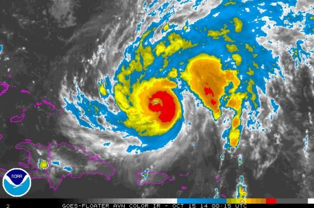
The north and west side of the core looked a little unimpressive earlier, but after some fluctuations it looks like it might finally be trying to develop a more uniform and solid presentation on the IR imagery. Would like to see the eye surrounded by an unbroken band of deep crimson to be really impressed with its presentation, though it's plenty impressive already, considering these last couple of hurricance seasons...

0 likes
Colors of lost purpose on the canvas of irrelevance
Not a meteorologist, in fact more of an idiot than anything. You should probably check with the NHC or a local NWS office for official information.
Not a meteorologist, in fact more of an idiot than anything. You should probably check with the NHC or a local NWS office for official information.
-
cycloneye
- Admin
- Posts: 149511
- Age: 69
- Joined: Thu Oct 10, 2002 10:54 am
- Location: San Juan, Puerto Rico
Re:
gatorcane wrote:Do we have anybody from Bermuda on this board? I would love to hear what is going on there. Could be a major hurricane for the island.
Also, when was the last time Bermuda saw a major hurricane?
JahJa,is one member there but I know there is another one. FYI,theree is a sticky thread at the top of the forum where you can go and see how things are in Bermuda. There is a link to the news from Bermuda that he provided at that thread.
0 likes
Visit the Caribbean-Central America Weather Thread where you can find at first post web cams,radars
and observations from Caribbean basin members Click Here
and observations from Caribbean basin members Click Here
-
ozonepete
- Professional-Met
- Posts: 4743
- Joined: Mon Sep 07, 2009 3:23 pm
- Location: From Ozone Park, NYC / Now in Brooklyn, NY
Re: ATL: GONZALO - Hurricane - Discussion
Satellite presentation continues to improve. The circulation is much more symmetrical now, with a very circular rather than elliptical core and the most intense thunderstorms are closing off in a substantial wall around a pinhole eye now. This configuration favors continued strengthening since it should not allow for any eyewall replacements for a while yet.

0 likes
-
ozonepete
- Professional-Met
- Posts: 4743
- Joined: Mon Sep 07, 2009 3:23 pm
- Location: From Ozone Park, NYC / Now in Brooklyn, NY
Re: ATL: GONZALO - Hurricane - Discussion
I guess we'll soon be doing wobble watches for the first time in quite a while. 
0 likes
Seems like the winds are down slightly with each pass and the pressure has leveled off again. And the plane is going NW after going through the eye, is the mission over?
Last edited by Hammy on Tue Oct 14, 2014 8:34 pm, edited 1 time in total.
0 likes
The above post is not official and should not be used as such. It is the opinion of the poster and may or may not be backed by sound meteorological data. It is not endorsed by any professional institution or storm2k.org. For official information, please refer to the NHC and NWS products.

Re: Re:
Yep. There are other similarities between Gonzalo and Fabian:CrazyC83 wrote:gatorcane wrote:Do we have anybody from Bermuda on this board? I would love to hear what is going on there. Could be a major hurricane for the island.
Also, when was the last time Bermuda saw a major hurricane?
Fabian 2003. Did over $300M in damage and 4 deaths.
- The eye of Fabian passed to the west of Bermuda and Gonzalo is currently projected to do the same
- Fabian struck on a Friday and Gonzalo is currently projected to do the same
Here's an interesting account of Fabian's wrath:
[youtube]http://www.youtube.com/watch?v=E7iKD5yzMhA[/youtube]
The content of this post does NOT constitute official forecast and should not be used as such. They are the opinion of the poster and may or may not be backed by sound meteorological data. They are NOT endorsed by any professional institution or Storm2K. For official information, please refer to the local meteorological centers of respective areas.
0 likes
-
TheAustinMan

- Category 5
- Posts: 1060
- Joined: Mon Jul 08, 2013 4:26 pm
- Location: Central TX / United States
Latest reconnaissance dropsonde indicating a minimum pressure of 955mbar and reporting 129 mph winds.
Last edited by TheAustinMan on Tue Oct 14, 2014 8:39 pm, edited 1 time in total.
0 likes
Treat my opinions with a grain of salt. For official information see your local weather service.
“It's tough to make predictions, especially about the future.”
“It's tough to make predictions, especially about the future.”
-
supercane4867
- Category 5
- Posts: 4966
- Joined: Wed Nov 14, 2012 10:43 am
Re: ATL: GONZALO - Hurricane - Discussion
Dropsonde Location: Dropped in eyewall 45° (NE) from the eye center.
Level Wind Direction Wind Speed
965mb (Surface) 320° (from the NW) 112 knots (129 mph)
962mb 320° (from the NW) 118 knots (136 mph)
956mb 325° (from the NW) 110 knots (127 mph)
953mb 330° (from the NNW) 120 knots (138 mph)
945mb 335° (from the NNW) 129 knots (148 mph)
942mb 340° (from the NNW) 125 knots (144 mph)
937mb 340° (from the NNW) 128 knots (147 mph)
933mb 345° (from the NNW) 118 knots (136 mph)
925mb 350° (from the N) 109 knots (125 mph)
916mb 0° (from the N) 130 knots (150 mph)
907mb 5° (from the N) 112 knots (129 mph)
903mb 10° (from the N) 122 knots (140 mph)
900mb 10° (from the N) 122 knots (140 mph)
899mb 25° (from the NNE) 128 knots (147 mph)
889mb 25° (from the NNE) 117 knots (135 mph)
876mb 25° (from the NNE) 123 knots (142 mph)
865mb 35° (from the NE) 114 knots (131 mph)
856mb 45° (from the NE) 129 knots (148 mph)
850mb 45° (from the NE) 130 knots (150 mph)
0 likes
-
TheAustinMan
- Category 5
- Posts: 1060
- Joined: Mon Jul 08, 2013 4:26 pm
- Location: Central TX / United States
Re: ATL: GONZALO - Hurricane - Discussion
supercane4867 wrote:Dropsonde Location: Dropped in eyewall 45° (NE) from the eye center.
Level Wind Direction Wind Speed
965mb (Surface) 320° (from the NW) 112 knots (129 mph)
Considering the dropsonde was dropped in the northeastern quadrant and dropped in a location with winds blowing from the northwest shows that it traveled quite a distance on its descent. Also considering that these winds are in the southwest quadrant, we may be looking at a Category 4 right now.
0 likes
Treat my opinions with a grain of salt. For official information see your local weather service.
“It's tough to make predictions, especially about the future.”
“It's tough to make predictions, especially about the future.”
Who is online
Users browsing this forum: No registered users and 68 guests