

beoumont wrote:Bahamas wx wrote --" I don't know how legit that image is. I was present in Nassau for Michelle, and although there was a long calm period during the eye, it was always 100% overcast--not an ounce of blue sky."
You must have looked out at the wrong moment. Me, Jim Leonard, Mike Theis, Brad Riley all intercepted Michelle on Paradise Island (Nassau suburb). Check their websites for similar images. Not only was there clear skies in the "eye" captured on video by all of us for nearly an hour, there was the unusual occurrence of sunlit skies on the backside circulation with 90 mph sustained winds for over a half hour with the sun shining through a very thin cirrus cover SW of the calm center. Thanks for the compliment on the highly rare photo.
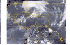
Below, albeit low quality, is satellite image of Michelle at the same time as the clear eye from the ground image; showing a clear center.
Better quality, showing the same http://199.9.2.143/tcdat/tc01/ATL/15L.MICHELLE/vis/geo/1km/20011105.1402.goes-8.vis.x.15LMICHELLE.70kts-974mb.jpg
CrazyC83 wrote:Given its small size, the ERC may drop the intensity quite a bit - perhaps to Cat 2.
I'd say very likely, probably even by tonight, and in fact the strengthening is likely over for the duration at this point.


