
Finally this El Nino seems to be materializing: ssta's have been on the steady increase past week or two with no significant decline, SOI negative.
Question is, is this warming permanent? Or is it temporary, only being enhanced by a hurricane or other temporary feature?
ENSO Updates (2007 thru 2023)
Moderator: S2k Moderators
Forum rules

The posts in this forum are NOT official forecasts and should not be used as such. They are just the opinion of the poster and may or may not be backed by sound meteorological data. They are NOT endorsed by any professional institution or STORM2K. For official information, please refer to products from the National Hurricane Center and National Weather Service.
Re: ENSO Updates
0 likes
This post is NOT AN OFFICIAL FORECAST and should not be used as such. It is just the opinion of the poster and may or may not be backed by sound meteorological data. It is NOT endorsed by any professional institution including storm2k.org. For Official Information please refer to the NHC and NWS products.
-
cycloneye

- Admin

- Posts: 148895
- Age: 69
- Joined: Thu Oct 10, 2002 10:54 am
- Location: San Juan, Puerto Rico
Re: ENSO Updates
The upcoming El Nino may not help California to aliviate the drought.Read why below.
REUTERS/Ilya Naymushin
BY MARK KOBA,
CNBC
October 21, 2014
Every week, a government weather agency releases a report on the conditions of California's drought. And every week seems to bring grim news. The latest report is no exception. The National Oceanic and Atmospheric Administration said Thursday that California's record-setting drought—heading into its fourth year—will likely persist or even intensify in large parts of the state.
"Complete drought recovery in California this winter is highly unlikely," said Mike Halpert, acting director of NOAA's Climate Prediction Center, in releasing the analysis.
Related: Extreme California Drought Pays Off for Some
"While we're predicting at least a 2 to 3 percent chance that precipitation will be near normal or above normal throughout the state, with such widespread, extreme deficits (in rainfall) the recovery will be slow," Halpert added.
The fact that the drought is nowhere near ending means the hard times will only get worse, said Michael Hanemann, an environmental economist at Arizona State University. "Another dry winter will mean this is going into territory we haven't had before," said Hanemann. "We'll have even less water to distribute, putting more stress on the system," he said. "We'll likely have more severe water shortages next spring and summer."
Record Low for Rain
There had been hope for heavy rains this winter. The weather condition known as El Nino was expected to bring strong rains to the state, but those projections have been toned way down. Now NOAA predicts that even if El Nino does occur, it is expected to be weak with little rainfall.
That prospect is coming on top of an already dire situation. This past year was the fourth-driest year ever for California based on rainfall and water runoff measurements. It got only around 60 percent of the yearly average precipitation.
- See more at: http://www.thefiscaltimes.com/2014/10/21/Even-El-N ino-May-Not-Help-Californias-Drought#sthash.rymt4F 9v.dpuf
0 likes
Visit the Caribbean-Central America Weather Thread where you can find at first post web cams,radars
and observations from Caribbean basin members Click Here
and observations from Caribbean basin members Click Here
-
xtyphooncyclonex

- Category 5

- Posts: 3889
- Age: 24
- Joined: Sat Dec 08, 2012 9:07 am
- Location: Cebu City
- Contact:
CFSv2 has the EL NIÑO nearing strong threshold by July....
0 likes
REMINDER: My opinions that I, or any other NON Pro-Met in this forum, are unofficial. Please do not take my opinions as an official forecast and warning. I am NOT a meteorologist. Following my forecasts blindly may lead to false alarm, danger and risk if official forecasts from agencies are ignored.

Re: ENSO Updates
Looks like all Ninos regions have continued to warm up by looking at the graphics, an official El Nino is just around the corner, IMO.
0 likes
-
cycloneye
- Admin
- Posts: 148895
- Age: 69
- Joined: Thu Oct 10, 2002 10:54 am
- Location: San Juan, Puerto Rico
Re: ENSO: CPC 10/27/14 update=Nino 3.4 remains at +0.5C
CPC in it's weekly update has Nino 3.4 at +0.5C and that is the same as last week's update.
http://www.cpc.noaa.gov/products/analys ... ts-web.pdf
http://www.cpc.noaa.gov/products/analys ... ts-web.pdf
0 likes
Visit the Caribbean-Central America Weather Thread where you can find at first post web cams,radars
and observations from Caribbean basin members Click Here
and observations from Caribbean basin members Click Here
-
euro6208
Re: ENSO: CPC 10/27/14 update=Nino 3.4 remains at +0.5C
BOM in their weekly update now at +0.6...
0 likes
-
Kingarabian

- S2K Supporter

- Posts: 16330
- Joined: Sat Aug 08, 2009 3:06 am
- Location: Honolulu, Hawaii
-
dexterlabio
- Category 5
- Posts: 3499
- Joined: Sat Oct 24, 2009 11:50 pm
Re: ENSO Updates
Kingarabian wrote:About time...
Watch it drop to 0.3C+ for absolutely no reason.
There's nothing to hold it back now, IMO. We have a potentially warm ENSO this Autumn and additional warming is favored as we get into NHem Winter. There also seems to be a new subsurface warm pool in WPAC as the present one is just about to emerge at the surface.
0 likes
Personal Forecast Disclaimer:
The posts in this forum are NOT official forecast and should not be used as such. They are just the opinion of the poster and may or may not be backed by sound meteorological data. They are NOT endorsed by any professional institution or storm2k.org. For official information, please refer to the NHC and NWS products.
The posts in this forum are NOT official forecast and should not be used as such. They are just the opinion of the poster and may or may not be backed by sound meteorological data. They are NOT endorsed by any professional institution or storm2k.org. For official information, please refer to the NHC and NWS products.
-
cycloneye
- Admin
- Posts: 148895
- Age: 69
- Joined: Thu Oct 10, 2002 10:54 am
- Location: San Juan, Puerto Rico
Re: ENSO Updates=SOI at El Nino Threshold below -8
A true sign of El Nino coming soon is the crash of the 30 day SOI to below -8 at El Nino threshold. That new warm subsurface pool growing in the WestCentral Pacific will be the key to put El Nino officially over the top.


0 likes
Visit the Caribbean-Central America Weather Thread where you can find at first post web cams,radars
and observations from Caribbean basin members Click Here
and observations from Caribbean basin members Click Here
-
Hurricaneman

- Category 5
- Posts: 7404
- Age: 45
- Joined: Tue Aug 31, 2004 3:24 pm
- Location: central florida
Re: ENSO Updates=SOI at El Nino Threshold below -8
Looking at the tropical tidbits site it seems to be showing an emerging El Nino madoki, lets see how that progresses as we go into 2015 as even though it could end up an el nino it could very well be a madoki one which a lot of the time leads to an active hurricane season
The posts in this forum are NOT official forecast and should not be used as such. They are just the opinion of the poster and may or may not be backed by sound meteorological data. They are NOT endorsed by any professional institution or storm2k.org. For official information, please refer to the NHC and NWS products
The posts in this forum are NOT official forecast and should not be used as such. They are just the opinion of the poster and may or may not be backed by sound meteorological data. They are NOT endorsed by any professional institution or storm2k.org. For official information, please refer to the NHC and NWS products
0 likes
-
cycloneye
- Admin
- Posts: 148895
- Age: 69
- Joined: Thu Oct 10, 2002 10:54 am
- Location: San Juan, Puerto Rico
Re: ENSO Updates=SOI at El Nino Threshold below -8
Is possible that the upcoming El Nino is going to be a Modoki one but is early yet to know.

0 likes
Visit the Caribbean-Central America Weather Thread where you can find at first post web cams,radars
and observations from Caribbean basin members Click Here
and observations from Caribbean basin members Click Here
Re: ENSO Updates=SOI at El Nino Threshold below -8
Yes, too early to know for sure if this will turn into a Modoki El Nino, but if it does it will not be good for southern California's water deficit, IMO.
0 likes
-
Hurricaneman
- Category 5
- Posts: 7404
- Age: 45
- Joined: Tue Aug 31, 2004 3:24 pm
- Location: central florida
Re: ENSO Updates=SOI at El Nino Threshold below -8
The NOAA charts don't agree with the tropical tidbits charts so I'm guessing that it could be errors in the data at the tropical tidbits site, we'll have to see what it looks like when the next update on the NOAA site to see
0 likes
-
Yellow Evan

- Professional-Met

- Posts: 16214
- Age: 27
- Joined: Fri Jul 15, 2011 12:48 pm
- Location: Henderson, Nevada/Honolulu, HI
- Contact:
Re: ENSO Updates=SOI at El Nino Threshold below -8
Hurricaneman wrote:Looking at the tropical tidbits site it seems to be showing an emerging El Nino madoki, lets see how that progresses as we go into 2015 as even though it could end up an el nino it could very well be a madoki one which a lot of the time leads to an active hurricane season
The posts in this forum are NOT official forecast and should not be used as such. They are just the opinion of the poster and may or may not be backed by sound meteorological data. They are NOT endorsed by any professional institution or storm2k.org. For official information, please refer to the NHC and NWS products
Levi's site uses satellite data only. And why would a Modoki lead to an active hurricane season? 2004 is overrated, although epic. 2002 was meh aside from a nice 4 week stretch and was mostly high latitude crap aside from Lili and Isidore. 1991 was quiet, ditto for the most part 1994. 2009 was a Modoki but not for the hurricane season. 1991-92 was not a Modoki at the end IIRC.
0 likes
Re: ENSO Updates=SOI at El Nino Threshold below -8
Yellow Evan wrote:Hurricaneman wrote:Looking at the tropical tidbits site it seems to be showing an emerging El Nino madoki, lets see how that progresses as we go into 2015 as even though it could end up an el nino it could very well be a madoki one which a lot of the time leads to an active hurricane season
The posts in this forum are NOT official forecast and should not be used as such. They are just the opinion of the poster and may or may not be backed by sound meteorological data. They are NOT endorsed by any professional institution or storm2k.org. For official information, please refer to the NHC and NWS products
Levi's site uses satellite data only. And why would a Modoki lead to an active hurricane season? 2004 is overrated, although epic. 2002 was meh aside from a nice 4 week stretch and was mostly high latitude crap aside from Lili and Isidore. 1991 was quiet, ditto for the most part 1994. 2009 was a Modoki but not for the hurricane season. 1991-92 was not a Modoki at the end IIRC.
IMO, next year should be more active for the Atlantic Season regardless if this winter's El Nino is a Modoki or not, look at 2010. I am not buying the idea that El Nino would persist through next year's hurricane season.
Unless dry conditions persist at the MDR once again through next year.
0 likes
-
Yellow Evan
- Professional-Met
- Posts: 16214
- Age: 27
- Joined: Fri Jul 15, 2011 12:48 pm
- Location: Henderson, Nevada/Honolulu, HI
- Contact:
Re: ENSO Updates=SOI at El Nino Threshold below -8
NDG wrote:Yellow Evan wrote:Hurricaneman wrote:Looking at the tropical tidbits site it seems to be showing an emerging El Nino madoki, lets see how that progresses as we go into 2015 as even though it could end up an el nino it could very well be a madoki one which a lot of the time leads to an active hurricane season
The posts in this forum are NOT official forecast and should not be used as such. They are just the opinion of the poster and may or may not be backed by sound meteorological data. They are NOT endorsed by any professional institution or storm2k.org. For official information, please refer to the NHC and NWS products
Levi's site uses satellite data only. And why would a Modoki lead to an active hurricane season? 2004 is overrated, although epic. 2002 was meh aside from a nice 4 week stretch and was mostly high latitude crap aside from Lili and Isidore. 1991 was quiet, ditto for the most part 1994. 2009 was a Modoki but not for the hurricane season. 1991-92 was not a Modoki at the end IIRC.
IMO, next year should be more active for the Atlantic Season regardless if this winter's El Nino is a Modoki or not, look at 2010. I am not buying the idea that El Nino would persist through next year's hurricane season.
Unless dry conditions persist at the MDR once again through next year.
Well, we might have no El Nino this year. And even then, why aren't you buying the idea of an El Nino next year, regardless if we get one this winter or not? It's too soon to say the ATL is going to be active.
0 likes
-
cycloneye
- Admin
- Posts: 148895
- Age: 69
- Joined: Thu Oct 10, 2002 10:54 am
- Location: San Juan, Puerto Rico
Re: ENSO Updates=SOI at El Nino Threshold below -8
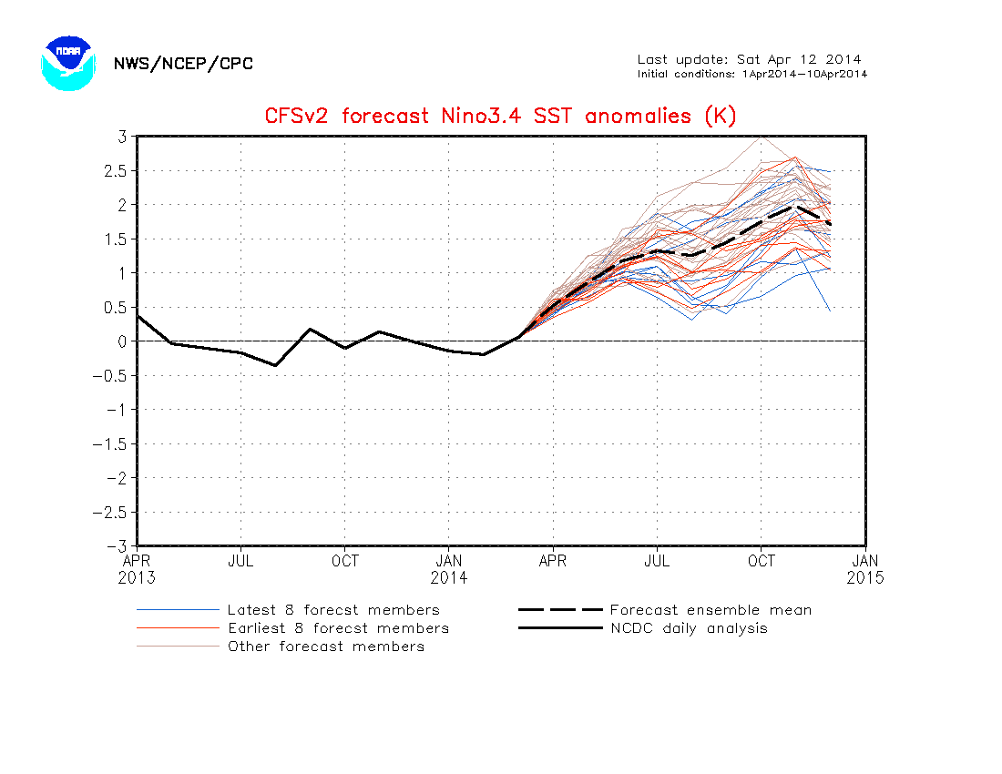
NDG,in other words you dont believe what CFSv2 forecasts of El Nino extending thru the first 7 months of 2015 and in fact turning from Weak to Moderate late in the forecast period.

0 likes
Visit the Caribbean-Central America Weather Thread where you can find at first post web cams,radars
and observations from Caribbean basin members Click Here
and observations from Caribbean basin members Click Here
Re: ENSO Updates=SOI at El Nino Threshold below -8
Yellow Evan wrote:NDG wrote:Yellow Evan wrote:
Levi's site uses satellite data only. And why would a Modoki lead to an active hurricane season? 2004 is overrated, although epic. 2002 was meh aside from a nice 4 week stretch and was mostly high latitude crap aside from Lili and Isidore. 1991 was quiet, ditto for the most part 1994. 2009 was a Modoki but not for the hurricane season. 1991-92 was not a Modoki at the end IIRC.
IMO, next year should be more active for the Atlantic Season regardless if this winter's El Nino is a Modoki or not, look at 2010. I am not buying the idea that El Nino would persist through next year's hurricane season.
Unless dry conditions persist at the MDR once again through next year.
Well, we might have no El Nino this year. And even then, why aren't you buying the idea of an El Nino next year, regardless if we get one this winter or not? It's too soon to say the ATL is going to be active.
IMO, all indications are that we will have an El Nino though weak one, though it was not official the atmosphere also behaved very much like an El Nino during hurricane season across the EPAC and the Caribbean.
The reason why I am not buying the idea of an El Nino for next year is because I simply do not believe in long range forecast for the ENSO regions.
0 likes
Re: ENSO Updates=SOI at El Nino Threshold below -8
cycloneye wrote:NDG,in other words you dont believe what CFSv2 forecasts of El Nino extending thru the first 7 months of 2015 and in fact turning from Weak to Moderate late in the forecast period.
http://oi61.tinypic.com/90r19y.jpg
Like I mentioned in the post above, I got to the point to where I do not believe in any long range forecasts for ENSO regions.
If the CFSv2 would had been correct a few months ago we would had been in moderate to strong El Nino by now.
0 likes

Re: ENSO Updates=SOI at El Nino Threshold below -8
Interesting that Modoki El Nino is possible. The last El Nino was Modoki, which was 2009-2010. I notice hurricane seasons following Modoki El Nino tend to be very active like 1995, 2005, and 2010.
0 likes
Who is online
Users browsing this forum: No registered users and 125 guests