Met Office to build £97m supercomputer
Let's see how this new tool improves more than they are doing now the ECMWF and UKMET.
http://www.bbc.com/news/science-environment-29789208
Global model runs discussion
Moderator: S2k Moderators
-
cycloneye

- Admin

- Posts: 149275
- Age: 69
- Joined: Thu Oct 10, 2002 10:54 am
- Location: San Juan, Puerto Rico
Re: Global Model Runs Discussion
0 likes
Visit the Caribbean-Central America Weather Thread where you can find at first post web cams,radars
and observations from Caribbean basin members Click Here
and observations from Caribbean basin members Click Here
-
gatorcane

- S2K Supporter

- Posts: 23708
- Age: 48
- Joined: Sun Mar 13, 2005 3:54 pm
- Location: Boca Raton, FL
Re: Global Model Runs Discussion
Hammy wrote:Euro is developing another storm in about nine days on the end of a frontal boundary.
Here is the 240 hour frame with the system heading towards the NW with a large ridge over the NE United States building in. Strange setup for November. Not much to see on the GFS except I do see it showing a large area of disturbed weather retrograding west from the tail end of the front. Let's see if future Euro runs continue with this:


0 likes
-
gatorcane
- S2K Supporter
- Posts: 23708
- Age: 48
- Joined: Sun Mar 13, 2005 3:54 pm
- Location: Boca Raton, FL
Re: Global Model Runs Discussion
cycloneye wrote:Met Office to build £97m supercomputer
Let's see how this new tool improves more than they are doing now the ECMWF and UKMET.
http://www.bbc.com/news/science-environment-29789208
Wow looks like a very impressive supercomputer. That is great the UK is investing so much in computer weather forecasting models. Does anybody know what the plans are for this country to upgrade their systems - namely the GFS model?
Also, are we going to have access to this model's output like we have for the UKMET or is it going to be more like the ECMWF where data is proprietary?
0 likes

Re: Global Model Runs Discussion
The year of the trough. Updated graphic. Amazing how stuck the pattern has been. Bermuda surely wants to see this end I would think.

0 likes
The following post is NOT an official forecast and should not be used as such. It is just the opinion of the poster and may or may not be backed by sound meteorological data. It is NOT endorsed by any professional institution including storm2k.org For Official Information please refer to the NHC and NWS products.
-
cycloneye
- Admin
- Posts: 149275
- Age: 69
- Joined: Thu Oct 10, 2002 10:54 am
- Location: San Juan, Puerto Rico
Re: Global Model Runs Discussion
Also, are we going to have access to this model's output like we have for the UKMET or is it going to be more like the ECMWF where data is proprietary?
gatorcane,I am sure that as time goes by before the September 2015 upgrade there will be more details about what you are asking.
0 likes
Visit the Caribbean-Central America Weather Thread where you can find at first post web cams,radars
and observations from Caribbean basin members Click Here
and observations from Caribbean basin members Click Here
-
TheStormExpert
Re: Global Model Runs Discussion
Hammy wrote:Euro is developing another storm in about nine days on the end of a frontal boundary.
12z Euro no longer develops it due to strong EC trough, unlike 00z where there was strong ridging instead.
0 likes
-
SFLcane

- S2K Supporter
- Posts: 10281
- Age: 48
- Joined: Sat Jun 05, 2010 1:44 pm
- Location: Lake Worth Florida
Re: Global Model Runs Discussion
Its been the year of the trof for a few seasons now. New prime zone for development 30n in the Atlantic.
0 likes
-
gatorcane
- S2K Supporter
- Posts: 23708
- Age: 48
- Joined: Sun Mar 13, 2005 3:54 pm
- Location: Boca Raton, FL
Global models seem to be advertising the possibility of some kind of weak low / area of disturbed weather that forms from the tail end of an anomalously strong cold front (same front that is causing the below normal temperatures this weekend over the Eastern United States) just a little north of Puerto Rico and retrogrades back west starting around 5-6 days from now. I included the 00Z ECMWF 168 hour image below as an example
None of them are showing development in the 00Z runs, but curious what ends up happening to this feature. Given it's late in the season out there for getting development, I am not expecting anything significant to come of this, but something to keep an eye on as that is the only thing I can see looking at the models that has the slightest chance of tropical development through the next 10 days.

None of them are showing development in the 00Z runs, but curious what ends up happening to this feature. Given it's late in the season out there for getting development, I am not expecting anything significant to come of this, but something to keep an eye on as that is the only thing I can see looking at the models that has the slightest chance of tropical development through the next 10 days.
0 likes
-
AJC3

- Admin
- Posts: 4153
- Age: 62
- Joined: Tue Aug 31, 2004 7:04 pm
- Location: Ballston Spa, New York
- Contact:
Re:
gatorcane wrote:Global models seem to be advertising the possibility of some kind of weak low / area of disturbed weather that forms from the tail end of an anomalously strong cold front (same front that is causing the below normal temperatures this weekend over the Eastern United States) just a little north of Puerto Rico and retrogrades back west starting around 5-6 days from now. I included the 00Z ECMWF 168 hour image below as an example
None of them are showing development in the 00Z runs, but curious what ends up happening to this feature. Given it's late in the season out there for getting development, I am not expecting anything significant to come of this, but something to keep an eye on as that is the only thing I can see looking at the models that has the slightest chance of tropical development through the next 10 days.
The 12Z/18Z global guidance is pointing to the base of the 500MB trough pinching off in the western Atlantic somewhere near 25N 70W in about 4.5 days, then continuing to drop southwestward for another day or two and then slowly westward as it gets trapped beneath a building ridge to the north. To me this is a pretty strong signal, and suggests unsettled weather (storms, heavy rain) for the DR/PR area next week, with the (baroclinic) development or enhancement of an inverted surface trough (the stalled frontal boundary) in that area.


0 likes
Re: Global Model Runs Discussion
Thanks for posting.
0 likes
The following post is NOT an official forecast and should not be used as such. It is just the opinion of the poster and may or may not be backed by sound meteorological data. It is NOT endorsed by any professional institution including storm2k.org For Official Information please refer to the NHC and NWS products.
Re: Global Model Runs Discussion
Levi Cowan now posting Parallel GFS runs on his site. I did not know they were going to upgrade the GFS. That is great news. 
A limited selection of Parallel GFS products are available in real-time until the GFS gets officially upgraded in December.
0 likes
The following post is NOT an official forecast and should not be used as such. It is just the opinion of the poster and may or may not be backed by sound meteorological data. It is NOT endorsed by any professional institution including storm2k.org For Official Information please refer to the NHC and NWS products.
-
Yellow Evan

- Professional-Met

- Posts: 16231
- Age: 27
- Joined: Fri Jul 15, 2011 12:48 pm
- Location: Henderson, Nevada/Honolulu, HI
- Contact:
http://www.washingtonpost.com/blogs/cap ... er-behind/
Very long but interesting read. It's been one run, but I wasn't too impressed by the new parallel GFS. It seemed a bit conservative. I know the GFS took a lot of heat in 2012, but honestly, that year, from my observation, was the best the GFS has ever preformed.
I know nothing about the KMA and I'm not a fan of the UKMET, two other models the article mentions.
0 likes
-
tolakram
- Admin
- Posts: 20179
- Age: 62
- Joined: Sun Aug 27, 2006 8:23 pm
- Location: Florence, KY (name is Mark)
Re: Global Model Runs Discussion
The problem won't be fixed by throwing more hardware at it, in my opinion.
0 likes
M a r k
- - - - -
Join us in chat: Storm2K Chatroom Invite. Android and IOS apps also available.
The posts in this forum are NOT official forecasts and should not be used as such. Posts are NOT endorsed by any professional institution or STORM2K.org. For official information and forecasts, please refer to NHC and NWS products.
-
Yellow Evan
- Professional-Met
- Posts: 16231
- Age: 27
- Joined: Fri Jul 15, 2011 12:48 pm
- Location: Henderson, Nevada/Honolulu, HI
- Contact:
Re: Global Model Runs Discussion
Since I thought this comment was rather interesting, I will re-post it here (fee free to delete if deemed inappropriate).
Doing some more browsing, here are some graphics.
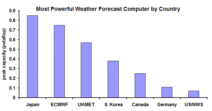
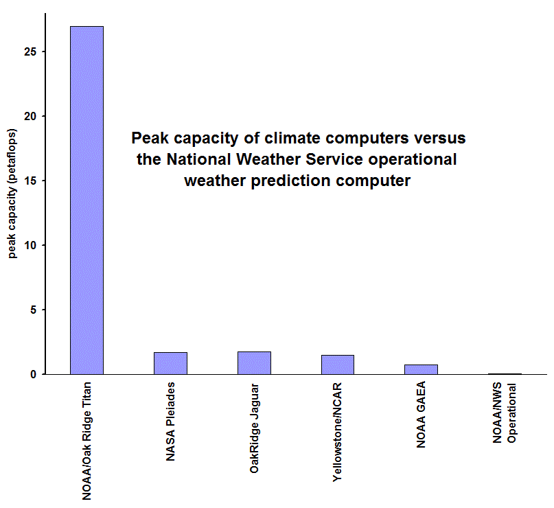
It turns out that NOAA made a very bad decision in their computer acquisitions. They committed themselves for an extended period to buy only from IBM, thus losing the ability to shop around for the best deal during each replacement cycle. And now IBM is planning to sell its server business to Lenovo, a Chinese company, and this is setting off all sorts of warning bells in the U.S. government, and specifically for the new weather computer acquisition. If NOAA was not stuck with IBM they could go with other vendors, like CRAY, which sells U.S. machines that have no security issues (in fact, the European Center liked them so much they bought one!).
Doing some more browsing, here are some graphics.
0 likes
-
somethingfunny

- ChatStaff

- Posts: 3926
- Age: 37
- Joined: Thu May 31, 2007 10:30 pm
- Location: McKinney, Texas
-
floridasun78
- Category 5

- Posts: 3755
- Joined: Sun May 17, 2009 10:16 pm
- Location: miami fl
Re:
somethingfunny wrote:Anything new on the horizon? I wouldn't be surprised to see a few more subtropical style popups
here Tropical Weather Outlook Text
TROPICAL WEATHER OUTLOOK
NWS NATIONAL HURRICANE CENTER MIAMI FL
700 AM EST MON NOV 3 2014
For the North Atlantic...Caribbean Sea and the Gulf of Mexico:
1. An area of low pressure is expected to form to the north of
Hispaniola around the middle of the week. This system could
acquire subtropical characteristics before it moves northward and
northeastward and weakens or merges with a frontal system toward the
end of the week.
* Formation chance through 48 hours...low...near 0 percent.
* Formation chance through 5 days...low...20 percent.
Forecaster Brown
0 likes
-
cycloneye
- Admin
- Posts: 149275
- Age: 69
- Joined: Thu Oct 10, 2002 10:54 am
- Location: San Juan, Puerto Rico
Re: Global Model Runs Discussion=New upgrade to GFS on Dec 17
New upgrade to GFS on December 17 at 12z
Let's see if this new upgrade eliminates the ghost storms.
Effective on or about December 17, 2014, beginning with the 1200
Coordinated Universal Time (UTC) run, the National Centers for
Environmental Prediction (NCEP) will upgrade the GFS Analysis and
Forecast System which includes:
- Changing model components
- Increasing horizontal resolution
- Adding 0.25 degree gridded output
- Adding new product fields
- Changing product naming convention
- Changing product timeliness
- Generating downstream model impacts
More at link below:
http://www.nws.noaa.gov/os/notification/tin14-46gfs.htm
0 likes
Visit the Caribbean-Central America Weather Thread where you can find at first post web cams,radars
and observations from Caribbean basin members Click Here
and observations from Caribbean basin members Click Here
Who is online
Users browsing this forum: No registered users and 33 guests