ENSO Updates (2007 thru 2023)
Moderator: S2k Moderators
Forum rules

The posts in this forum are NOT official forecasts and should not be used as such. They are just the opinion of the poster and may or may not be backed by sound meteorological data. They are NOT endorsed by any professional institution or STORM2K. For official information, please refer to products from the National Hurricane Center and National Weather Service.
-
cycloneye

- Admin

- Posts: 149442
- Age: 69
- Joined: Thu Oct 10, 2002 10:54 am
- Location: San Juan, Puerto Rico
Re: ENSO Updates=SOI at El Nino Threshold below -8
The most telling sign right now about El Nino coming soon is the SOI being very negative followed by the second sign and that is the warm pool growing in the WestCentral Pacific. Notice that I only say El Nino coming soon as is early to say if is going to be Modoki or Traditional and also if is going to be a Weak one or it may be stronger than that. I think by December going into January we may have a more clear picture.
0 likes
Visit the Caribbean-Central America Weather Thread where you can find at first post web cams,radars
and observations from Caribbean basin members Click Here
and observations from Caribbean basin members Click Here


Looks like 0.6C this week. Should be an interesting update given new month, lots of values coming out. CPC should be pretty close to declaring it.
0 likes
The above post and any post by Ntxw is NOT an official forecast and should not be used as such. It is just the opinion of the poster and may or may not be backed by sound meteorological data. It is NOT endorsed by any professional institution including Storm2k. For official information, please refer to NWS products.
Help support Storm2K!
-
cycloneye
- Admin
- Posts: 149442
- Age: 69
- Joined: Thu Oct 10, 2002 10:54 am
- Location: San Juan, Puerto Rico
Re:
Ntxw wrote:Looks like 0.6C this week. Should be an interesting update given new month, lots of values coming out. CPC should be pretty close to declaring it.
It's three weeks in a row at or above +0.5C.
0 likes
Visit the Caribbean-Central America Weather Thread where you can find at first post web cams,radars
and observations from Caribbean basin members Click Here
and observations from Caribbean basin members Click Here
Re: Re:
cycloneye wrote:Ntxw wrote:Looks like 0.6C this week. Should be an interesting update given new month, lots of values coming out. CPC should be pretty close to declaring it.
It's three weeks in a row at or above +0.5C.
Its also been hovering around 0.4C since late August, we had a week I think at 0.3C but averaging it all out its very close for 60-90 days worth.
0 likes
The above post and any post by Ntxw is NOT an official forecast and should not be used as such. It is just the opinion of the poster and may or may not be backed by sound meteorological data. It is NOT endorsed by any professional institution including Storm2k. For official information, please refer to NWS products.
Help support Storm2K!
Help support Storm2K!
-
cycloneye
- Admin
- Posts: 149442
- Age: 69
- Joined: Thu Oct 10, 2002 10:54 am
- Location: San Juan, Puerto Rico
Re: ENSO: CPC 11/3/14 update: Nino 3.4 up to +0.6C
Here is the text of the 11/3/14 weekly update by CPC that shows Nino 3.4 up to +0.6C and that is three weeks in a row with readings at or above +0.5C making the El Nino official declaration more closer.
http://www.cpc.noaa.gov/products/analys ... ts-web.pdf
http://www.cpc.noaa.gov/products/analys ... ts-web.pdf
0 likes
Visit the Caribbean-Central America Weather Thread where you can find at first post web cams,radars
and observations from Caribbean basin members Click Here
and observations from Caribbean basin members Click Here
Regarding about next year, as I've mentioned had the stronger Nino occurred this year a La Nina probably would've been a good shoo in. Weak Nino's increases the chances of a second Nino or neutral. It's not a good idea to trust anything at this point for next year. One thing to keep eyes on is the PDO. October is going to come in with another very +PDO number. The NPAC SST forecasts have been quite good this year and they are expecting it to continue into 2015, if that remains then we'll go from there.
0 likes
The above post and any post by Ntxw is NOT an official forecast and should not be used as such. It is just the opinion of the poster and may or may not be backed by sound meteorological data. It is NOT endorsed by any professional institution including Storm2k. For official information, please refer to NWS products.
Help support Storm2K!
Help support Storm2K!

-
cycloneye
- Admin
- Posts: 149442
- Age: 69
- Joined: Thu Oct 10, 2002 10:54 am
- Location: San Juan, Puerto Rico
Re: ENSO Updates
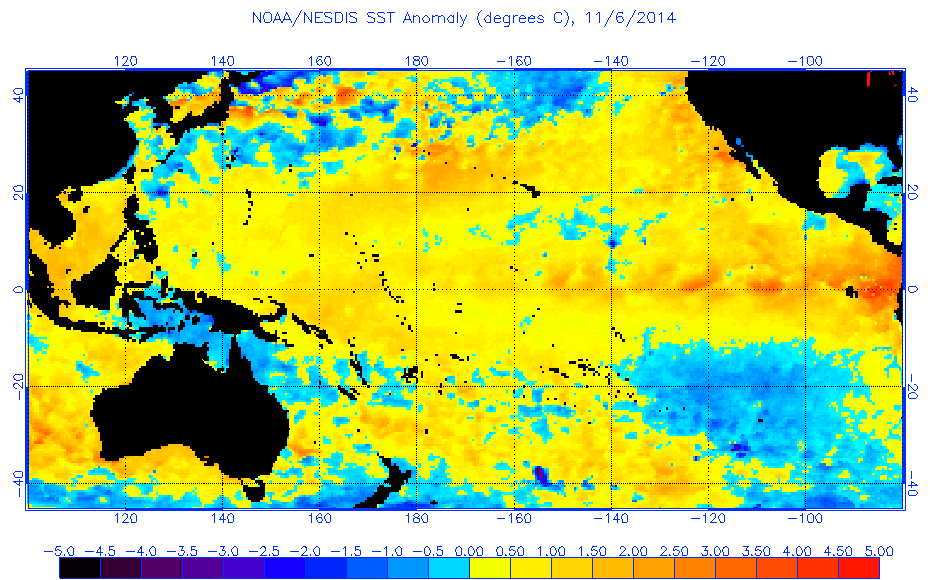
November update by CPC at 11/6/14 has a 58% chance of Weak El Nino by Northern Hemisphere Winter
That 58% is lower than the past couple of months when it was at 65%.
EL NIÑO/SOUTHERN OSCILLATION (ENSO)
DIAGNOSTIC DISCUSSION
issued by
CLIMATE PREDICTION CENTER/NCEP/NWS
and the International Research Institute for Climate and Society
6 November 2014
ENSO Alert System Status: El Niño Watch
Synopsis: There is a 58% chance of El Niño during the Northern Hemisphere winter, which is favored to last into the Northern Hemisphere spring 2015.
During October 2014, above-average sea surface temperatures (SST) increased slightly across the eastern half of the equatorial Pacific (Fig. 1). The weekly Niño indices were between +0.6oC (Niño-3.4 and Niño-1+2) and +0.9oC (Niño-3) at the end of the month (Fig. 2). Subsurface heat content anomalies (averaged between 180o-100oW) were largely unchanged (Fig. 3) even as a new downwelling Kelvin wave increased temperatures at depth in the central Pacific (Fig. 4). The monthly equatorial low-level winds were near average, although anomalous westerlies continued to emerge on occasion. Upper-level winds were also mostly average across the Pacific. The Southern Oscillation Index continued to be negative, accompanied by mostly average rainfall near the Date Line and suppressed rainfall over Indonesia (Fig. 5). Overall, several features across the tropical Pacific are characteristic of borderline El Niño conditions, but collectively, the combined atmosphere and oceanic state remains ENSO-neutral.
Similar to last month, most models predict El Niño to develop during October-December 2014 and to continue into early 2015 (Fig. 6). However, the ongoing lack of clear atmosphere-ocean coupling and the latest NCEP CFSv2 model forecast (Fig. 7) have reduced confidence that El Niño will fully materialize (at least five overlapping consecutive 3-month values of the Niño-3.4 index at or greater than 0.5oC). If El Niño does emerge, the forecaster consensus favors a weak event. In summary, there is a 58% chance of El Niño during the Northern Hemisphere winter, which is favored to last into the Northern Hemisphere spring 2015 (click CPC/IRI consensus forecast for the chance of each outcome).
http://www.cpc.noaa.gov/products/analys ... odisc.html
0 likes
Visit the Caribbean-Central America Weather Thread where you can find at first post web cams,radars
and observations from Caribbean basin members Click Here
and observations from Caribbean basin members Click Here
-
cycloneye
- Admin
- Posts: 149442
- Age: 69
- Joined: Thu Oct 10, 2002 10:54 am
- Location: San Juan, Puerto Rico
Re: CPC at 11/6/14 has 58% chance of Weak El Nino by Winter
Impressive stuff about all the details of the upcoming El Nino by Steve Gregory who is posting at Dr Masters blog while he is on vacation.Scroll down to read all about ENSO.
http://www.wunderground.com/blog/JeffMa ... #commentop
http://www.wunderground.com/blog/JeffMa ... #commentop
0 likes
Visit the Caribbean-Central America Weather Thread where you can find at first post web cams,radars
and observations from Caribbean basin members Click Here
and observations from Caribbean basin members Click Here
-
Kingarabian

- S2K Supporter

- Posts: 16361
- Joined: Sat Aug 08, 2009 3:06 am
- Location: Honolulu, Hawaii
Re: CPC at 11/6/14 has 58% chance of Weak El Nino by Winter
I really don't understand the CPC's lowering of the probabilities of an El Nino by this winter, if anything it looks like it is already here with SSTs anomaly and with the Peninsula of FL is going into a fairly wet pattern at least into the next couple of weeks.
0 likes

Re: CPC at 11/6/14 has 58% chance of Weak El Nino by Winter
NDG wrote:I really don't understand the CPC's lowering of the probabilities of an El Nino by this winter, if anything it looks like it is already here with SSTs anomaly and with the Peninsula of FL is going into a fairly wet pattern at least into the next couple of weeks.
I agree that an El Nino is definitely materializing and rapidly at that. My guess for your question is that the CPC probably doesn't want to take any chances just in case the weather changes its mind. Don't forget earlier this year with the historic Kelvin Wave. The CPC NOAA NWS was calling for a very high chance of El Nino by now, but soon afterwards, the warm pool faded big time. Now the El Nino is getting its act together, in my opinion for real this time, but the CPC NOAA NWS just wants to be on the safe side.
0 likes
This post is NOT AN OFFICIAL FORECAST and should not be used as such. It is just the opinion of the poster and may or may not be backed by sound meteorological data. It is NOT endorsed by any professional institution including storm2k.org. For Official Information please refer to the NHC and NWS products.
-
HURRICANELONNY
- Category 5

- Posts: 1392
- Joined: Wed May 07, 2003 6:48 am
- Location: HOLLYWOOD.FL
Looking at all the maps and data, I think we'll see 0.7C reading this coming week. CPC should considering declaring this soon.
0 likes
The above post and any post by Ntxw is NOT an official forecast and should not be used as such. It is just the opinion of the poster and may or may not be backed by sound meteorological data. It is NOT endorsed by any professional institution including Storm2k. For official information, please refer to NWS products.
Help support Storm2K!
Help support Storm2K!
-
cycloneye
- Admin
- Posts: 149442
- Age: 69
- Joined: Thu Oct 10, 2002 10:54 am
- Location: San Juan, Puerto Rico
Re: ENSO=SOI at El Nino Threshold below -8 and going down

0 likes
Visit the Caribbean-Central America Weather Thread where you can find at first post web cams,radars
and observations from Caribbean basin members Click Here
and observations from Caribbean basin members Click Here

0 likes
The above post and any post by Ntxw is NOT an official forecast and should not be used as such. It is just the opinion of the poster and may or may not be backed by sound meteorological data. It is NOT endorsed by any professional institution including Storm2k. For official information, please refer to NWS products.
Help support Storm2K!
Help support Storm2K!
Re: ENSO=SOI at El Nino Threshold below -8 and going down
To everyone saying that El Nino is close to being declared: Doesn't the 3.4 index have to be at least 0.5 for 5 consecutive seasons. We just completed ASO, should be close to 0.5. But even if it was 0.5, wouldn't we have to wait till the end of February? (ASO, SON, OND, NDJ, DJF)
0 likes
This post is NOT AN OFFICIAL FORECAST and should not be used as such. It is just the opinion of the poster and may or may not be backed by sound meteorological data. It is NOT endorsed by any professional institution including storm2k.org. For Official Information please refer to the NHC and NWS products.
Re: ENSO=SOI at El Nino Threshold below -8 and going down
asd123 wrote:To everyone saying that El Nino is close to being declared: Doesn't the 3.4 index have to be at least 0.5 for 5 consecutive seasons. We just completed ASO, should be close to 0.5. But even if it was 0.5, wouldn't we have to wait till the end of February? (ASO, SON, OND, NDJ, DJF)
NOAA's Climate Prediction Center, which is part of the National Weather Service, declares the onset of an El Ni�o episode when the 3-month average sea-surface temperature departure exceeds 0.5oC in the east-central equatorial Pacific [between 5oN-5oS and 170oW-120oW].
http://www.cpc.ncep.noaa.gov/products/a ... shtml#NINO
0 likes
Re: ENSO=SOI at El Nino Threshold below -8 and going down
NDG wrote:asd123 wrote:To everyone saying that El Nino is close to being declared: Doesn't the 3.4 index have to be at least 0.5 for 5 consecutive seasons. We just completed ASO, should be close to 0.5. But even if it was 0.5, wouldn't we have to wait till the end of February? (ASO, SON, OND, NDJ, DJF)NOAA's Climate Prediction Center, which is part of the National Weather Service, declares the onset of an El Ni�o episode when the 3-month average sea-surface temperature departure exceeds 0.5oC in the east-central equatorial Pacific [between 5oN-5oS and 170oW-120oW].
http://www.cpc.ncep.noaa.gov/products/a ... shtml#NINO
Understood. But then what is this? (http://www.cpc.noaa.gov/products/analys ... ts-web.pdf Slide 23: it says "5 consecutive overlapping seasons" for El Nino or La Nina This info is a little conflicting.
0 likes
This post is NOT AN OFFICIAL FORECAST and should not be used as such. It is just the opinion of the poster and may or may not be backed by sound meteorological data. It is NOT endorsed by any professional institution including storm2k.org. For Official Information please refer to the NHC and NWS products.
Re: ENSO=SOI at El Nino Threshold below -8 and going down
asd123 wrote:Understood. But then what is this? (http://www.cpc.noaa.gov/products/analys ... ts-web.pdf Slide 23: it says "5 consecutive overlapping seasons" for El Nino or La Nina
When we say declared we mean by them upgrading the watch into a warning meaning El Nino conditions have occurred and expected to continue. That definition is up to the CPC's interpretation based on if they believe all indicators are evident. An official El Nino won't be classified until after the 5 trimonthlies as you state but for forecasting purposes it's kind of pointless to use it to predict weather after it has already occured.
0 likes
The above post and any post by Ntxw is NOT an official forecast and should not be used as such. It is just the opinion of the poster and may or may not be backed by sound meteorological data. It is NOT endorsed by any professional institution including Storm2k. For official information, please refer to NWS products.
Help support Storm2K!
Help support Storm2K!
Who is online
Users browsing this forum: Hurricane2022, RomP, Ulf and 202 guests