
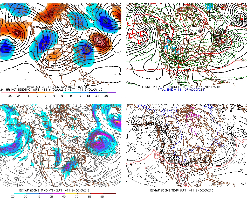
The -EPO is now forecasted not only to tank but is off the charts low. The AO keeps going lower as well and staying low.
We're about to end fall abrubtly and dive head first to winter
Texas Fall-2014
Moderator: S2k Moderators
Forum rules

The posts in this forum are NOT official forecast and should not be used as such. They are just the opinion of the poster and may or may not be backed by sound meteorological data. They are NOT endorsed by any professional institution or STORM2K.
Last edited by Ntxw on Fri Nov 07, 2014 8:28 am, edited 1 time in total.
0 likes
The above post and any post by Ntxw is NOT an official forecast and should not be used as such. It is just the opinion of the poster and may or may not be backed by sound meteorological data. It is NOT endorsed by any professional institution including Storm2k. For official information, please refer to NWS products.
Help support Storm2K!
-
Portastorm

- Storm2k Moderator

- Posts: 9955
- Age: 63
- Joined: Fri Jul 11, 2003 9:16 am
- Location: Round Rock, TX
- Contact:
Re: Texas Fall-2014
Wow ... did srainhoutx do a fabulous job of framing our discussion for the next 7-10 days or what?! Nice work, sir. 
Let's keep the dialogue rolling ... a lot of good posts in this thread the last few days.
Let's keep the dialogue rolling ... a lot of good posts in this thread the last few days.
0 likes
Any forecasts under my name are to be taken with a grain of salt. Get your best forecasts from the National Weather Service and National Hurricane Center.
-
TeamPlayersBlue

- Category 5

- Posts: 3530
- Joined: Tue Feb 02, 2010 1:44 am
- Location: Denver/Applewood, CO
Great post above. Really excited, im interested in what this secondary cold blast will look like and if something happens in the state of texas with it... Again still too early to see if any precip will be with it but im liking what i see
0 likes
Personal Forecast Disclaimer:
The posts in this forum are NOT official forecast and should not be used as such. They are just the opinion of the poster and may or may not be backed by sound meteorological data. They are NOT endorsed by any professional institution or storm2k.org. For official information, please refer to the NHC and NWS products.
The posts in this forum are NOT official forecast and should not be used as such. They are just the opinion of the poster and may or may not be backed by sound meteorological data. They are NOT endorsed by any professional institution or storm2k.org. For official information, please refer to the NHC and NWS products.
-
Ralph's Weather
- S2K Supporter

- Posts: 3371
- Age: 38
- Joined: Fri Dec 13, 2013 11:55 am
- Location: Lindale, TX
- Contact:
Looks like we are in for repeated cold shots and increasing chances for storminess as time goes on.
0 likes
Follow on Facebook at Ralph's Weather.
-
gatorcane

- S2K Supporter
- Posts: 23708
- Age: 48
- Joined: Sun Mar 13, 2005 3:54 pm
- Location: Boca Raton, FL
This storm and potential arctic outbreak for the lower 48 is starting to get national attention - of course we sniffed it out first here on storm2k!
http://news.yahoo.com/remnant-typhoon-n ... 35931.html
http://news.yahoo.com/remnant-typhoon-n ... 35931.html
0 likes
-
CYCLONE MIKE
- Category 5
- Posts: 2183
- Joined: Tue Aug 31, 2004 6:04 pm
- Location: Gonzales, LA
Re: Texas Fall-2014
I'm getting pumped about the potential of this coming winter down here. Need something after such a dismal hurricane season. Anyway don't know if any of y'all caught it last night but my wife was watching CNN and they were already talking about this potential outbreak as well. Of course they were hyping the dreaded "polar vortex" but people are starting to acknowledge the potential.
0 likes

Re: Texas Fall-2014
At the moment, the upcoming cold snap looks dry, perhaps some precip in Texas Friday into the weekend.
0 likes

-
Tireman4

- S2K Supporter
- Posts: 5903
- Age: 60
- Joined: Fri Jun 30, 2006 1:08 pm
- Location: Humble, Texas
- Contact:
Re: Texas Fall-2014
CYCLONE MIKE wrote:I'm getting pumped about the potential of this coming winter down here. Need something after such a dismal hurricane season. Anyway don't know if any of y'all caught it last night but my wife was watching CNN and they were already talking about this potential outbreak as well. Of course they were hyping the dreaded "polar vortex" but people are starting to acknowledge the potential.
Superpolarvortexmaggedon!!
0 likes
-
TheProfessor

- Professional-Met

- Posts: 3506
- Age: 29
- Joined: Tue Dec 03, 2013 10:56 am
- Location: Wichita, Kansas
How does this storm match up with the McFarland signature from last year, I know the cold and length of cold won't be the same, but how close are they related intensity wise?
0 likes
An alumnus of The Ohio State University.
Your local National Weather Service office is your best source for weather information.
Your local National Weather Service office is your best source for weather information.
-
srainhoutx

- S2K Supporter
- Posts: 6919
- Age: 68
- Joined: Sun Jan 14, 2007 11:34 am
- Location: Haywood County, NC
- Contact:
Re: Texas Fall-2014
A quick update on the 12Z parallel GFS regarding early next week. It is not often even in the heart of Winter we see a 1052mb Arctic High settling into Montana, much less on November 11th-12th. This my friends will be a true 'blue norther'...
0 likes
Carla/Alicia/Jerry(In The Eye)/Michelle/Charley/Ivan/Dennis/Katrina/Rita/Wilma/Ike/Harvey
Member: National Weather Association
Wx Infinity Forums
http://wxinfinity.com/index.php
Facebook.com/WeatherInfinity
Twitter @WeatherInfinity
Member: National Weather Association
Wx Infinity Forums
http://wxinfinity.com/index.php
Facebook.com/WeatherInfinity
Twitter @WeatherInfinity
Re:
TheProfessor wrote:How does this storm match up with the McFarland signature from last year, I know the cold and length of cold won't be the same, but how close are they related intensity wise?
I was about to make a post on it. At 500mb it is McFarland's signature block. Anomalous high pressures in the EPO/NP region and davis strait-hudson pv. However at the surface it is November and not DJF, but make no doubt it is potent.
0 likes
The above post and any post by Ntxw is NOT an official forecast and should not be used as such. It is just the opinion of the poster and may or may not be backed by sound meteorological data. It is NOT endorsed by any professional institution including Storm2k. For official information, please refer to NWS products.
Help support Storm2K!
Help support Storm2K!
Re: Texas Fall-2014
Look at the temp anomalies for next Friday via the parallel GFS! >50F below normal in parts of Montana and the Dakotas, with 25-30F below normal here in SE TX.
0 likes
-
srainhoutx
- S2K Supporter
- Posts: 6919
- Age: 68
- Joined: Sun Jan 14, 2007 11:34 am
- Location: Haywood County, NC
- Contact:
Re: Texas Fall-2014
ronyan wrote:Look at the temp anomalies for next Friday via the parallel GFS! >50F below normal in parts of Montana and the Dakotas, with 25-30F below normal here in SE TX.
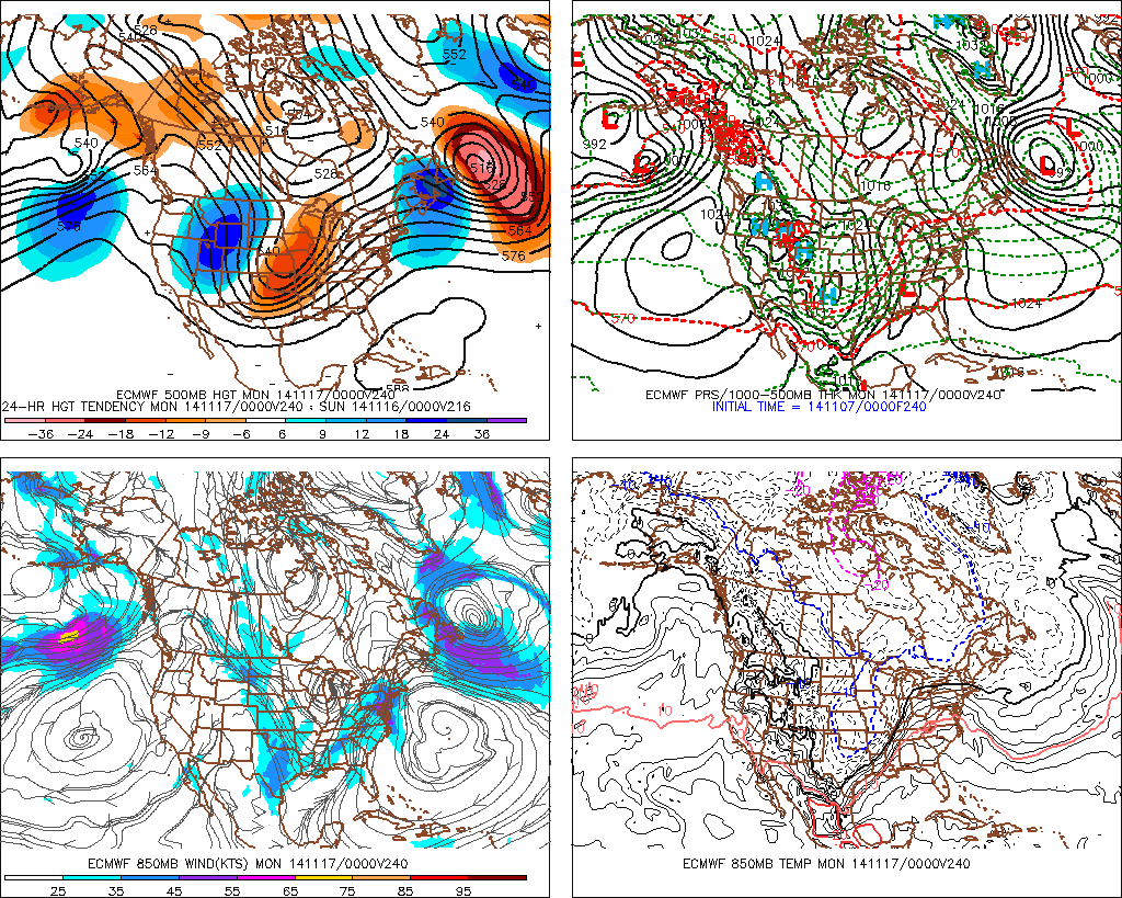
The p types for later next week are also interesting. The parallel GFS suggests light snow falling across the Central/Southern Plains as a secondary shortwave drops S. There are hints of over running precip developing into next weekend, so that will be something to monitor as we get into the mid next week timeframe to see if it verifies. Also the parallel GFS suggests a secondary surge of Arctic air nearing the Border next Saturday into Sunday, so the pattern may well reload into the longer range.
0 likes
Carla/Alicia/Jerry(In The Eye)/Michelle/Charley/Ivan/Dennis/Katrina/Rita/Wilma/Ike/Harvey
Member: National Weather Association
Wx Infinity Forums
http://wxinfinity.com/index.php
Facebook.com/WeatherInfinity
Twitter @WeatherInfinity
Member: National Weather Association
Wx Infinity Forums
http://wxinfinity.com/index.php
Facebook.com/WeatherInfinity
Twitter @WeatherInfinity
Great post srain, these arctic blasts usually comes with a storm we're just not in close enough yet for these things to be resolute on guidance yet. They will probably trend wetter as the days come.
0 likes
The above post and any post by Ntxw is NOT an official forecast and should not be used as such. It is just the opinion of the poster and may or may not be backed by sound meteorological data. It is NOT endorsed by any professional institution including Storm2k. For official information, please refer to NWS products.
Help support Storm2K!
Help support Storm2K!
-
Ralph's Weather
- S2K Supporter
- Posts: 3371
- Age: 38
- Joined: Fri Dec 13, 2013 11:55 am
- Location: Lindale, TX
- Contact:
Re: Texas Fall-2014
srainhoutx wrote:ronyan wrote:Look at the temp anomalies for next Friday via the parallel GFS! >50F below normal in parts of Montana and the Dakotas, with 25-30F below normal here in SE TX.
The p types for later next week are also interesting. The parallel GFS suggests light snow falling across the Central/Southern Plains as a secondary shortwave drops S. There are hints of over running precip developing into next weekend, so that will be something to monitor as we get into the mid next week timeframe to see if it verifies. Also the parallel GFS suggests a secondary surge of Arctic air nearing the Border next Saturday into Sunday, so the pattern may well reload into the longer range.
The models are starting to show what we have been expecting out of this with the initial surge of cold on Monday then a shortwave then a coastal low then repeat the next week. Or at least I think it will play out that way. I just do not see room for much warming in between and if we can get some good snow cover over the Plains next week we are set to go for winter.
0 likes
Follow on Facebook at Ralph's Weather.

I'm in camp with WXMAN57, UNLESS we get winter precip, then I don't mind it being just plain old cold.
If it is cold and dry, I'd rather it be in the 80's or 90's.
If it is cold and dry, I'd rather it be in the 80's or 90's.
0 likes
The above post and any post by dhweather is NOT an official forecast and should not be used as such. It is just the opinion of the poster and may or may not be backed by sound meteorological data. It is NOT endorsed by any professional institution including storm2k.org. For official information, please refer to NWS products.
Re: Texas Fall-2014
srainhoutx wrote:All system are go for a pleasant weekend and the upper low currently just S of the Big Bend finally weakens and shears out. The pesky upper low which helped in steering the remnants of EPAC TC Vance NE across Texas brought and 8 foot rise in the Edwards Aquifer in a 48 hour period. This sort of steady rainfall was sorely needed across Central Texas. A cold front will arrive on Saturday reinforcing the pleasant Fall temperatures before the big pattern change we've all heard about by now ahead for next week.
The Global Ensembles and Operational computer guidance is in remarkably good agreement the former Super Typhoon Nuri will transition into a powerful Extratropical Storm near the Bering Sea. In the water vapor satellite imagery above, the storm is now entering the far upper left of the imagery and should wrap up and be rather impressive via satellite visible pictures over the weekend into Monday. Winds near or above 80 MPH with wave heights nearing 50 feet are forecast and expect near the Aleutian Island and the Bering Sea. The Super Storm will buckle the jet stream and allow very impressive cold air that has been building across Eurasia/Siberia due to extremely heavy October snowfall near record territory to be pulled across the Arctic into North America and spill very far south into Texas, Mexico and eventually into the Yucatan and Cuba later next week. The Canadian Prairies have been getting snow over the past several weeks, but the Northern/Central Plains are lacking any snow, so airmass modification will occur. That said the coldest air of the season will plunge S along and E of the Continental Divide and remain entrenched with reinforcing shots of cold air with the fast moving Northerly flow aloft and embedded upper air energy (shortwaves) bring cold fronts in fairly rapid progression during next week. The teleconnection indices are aligning in a very impressive fashion that bring a very - Arctic Oscillation/AO (-4+) -North Atlantic Oscillation/NAO (-1.5+) -East Pacific Oscillation/EPO (-4+) +Pacific North America Pattern/PNA (+3) regime together next week and just beyond the mid November timeframe. What this means for the Southern Plains and Texas is a Ridge of High Pressure build off the West Coast into Eastern Alaska into the Arctic while a very deep trough develops across Central and Eastern North America. The Pattern become blocked across the Atlantic which would allow the cold air to sweep E and miss our Region as we see in most Fall and Winter patterns. The fly in the ointment is the sub tropical jet across the Pacific and what it may or may not bring as El Nino continues to unfold.
There is convection associated with a tropical disturbance (96E) several hundred miles off the W Coast of Mexico and the track guidance is suggesting this disturbance remains rather weak, but does turn it NE toward the Pacific Coast of Mexico next week. At the same time the computer guidance is 'sniffing' a robust piece of upper level energy (shortwave) under cutting the Ridge out W and developing a low pressure system along the front range of the Southern Rockies near New Mexico/Colorado. This happens later next week (around November 15th -17th) after the Arctic front arrives late on Monday into Tuesday. IF, and it is a big if the models such as the European are correct a big Winter like storm may develop across the Panhandle and cross the Southern Plains ushering in even colder air and build a snow cover across the Plains. If that happens, then much less airmass modification is a possibility. The guidance is suggesting another stronger Arctic front following this energy, so we have a lot of moving parts to follow on our weather plate and should lead to some interesting discussions as next week unfolds.
I did a post reply to get this on the current page - OUTSTANDING writeup by srainhoutex on the next 7-10 days - WELL DONE SIR !!!
0 likes
The above post and any post by dhweather is NOT an official forecast and should not be used as such. It is just the opinion of the poster and may or may not be backed by sound meteorological data. It is NOT endorsed by any professional institution including storm2k.org. For official information, please refer to NWS products.
-
Tireman4
- S2K Supporter
- Posts: 5903
- Age: 60
- Joined: Fri Jun 30, 2006 1:08 pm
- Location: Humble, Texas
- Contact:
Re: Texas Fall-2014
[
I did a post reply to get this on the current page - OUTSTANDING writeup by srainhoutex on the next 7-10 days - WELL DONE SIR !!![/quote]
That is because the man knows his weather. Again, amazing write up sir!!
I did a post reply to get this on the current page - OUTSTANDING writeup by srainhoutex on the next 7-10 days - WELL DONE SIR !!![/quote]
That is because the man knows his weather. Again, amazing write up sir!!
0 likes
Return to “USA & Caribbean Weather”
Who is online
Users browsing this forum: South Texas Storms, Stratton23 and 61 guests