Texas Fall-2014

U.S. & Caribbean Weather Discussions and Severe Weather Events

Moderator: S2k Moderators

Forum rules

The posts in this forum are NOT official forecast and should not be used as such. They are just the opinion of the poster and may or may not be backed by sound meteorological data. They are NOT endorsed by any professional institution or STORM2K.

Help Support Storm2K
Message
Author
User avatar
Ntxw
Storm2k Moderator
Storm2k Moderator
Posts: 22784
Joined: Wed Oct 21, 2009 6:34 pm
Location: DFW, Texas

#981 Postby Ntxw » Sat Nov 08, 2014 8:32 am

And there it is, the powerful record breaking Aleutian low/ex-Nuri. 924mb this morning breaking the record held by a storm in the bering in 1977 of 926mb.

Image

As a result the coldest air across the NHEM is beginning to drain into central and western Canada. WPC/HPC discussions suggests some -30s or greater temperatures in the Northern Rockies (US) next week is possible.
0 likes   
The above post and any post by Ntxw is NOT an official forecast and should not be used as such. It is just the opinion of the poster and may or may not be backed by sound meteorological data. It is NOT endorsed by any professional institution including Storm2k. For official information, please refer to NWS products.

  Help support Storm2K!
Help Support Storm2K

Ralph's Weather
S2K Supporter
S2K Supporter
Posts: 3269
Age: 38
Joined: Fri Dec 13, 2013 11:55 am
Location: Lindale, TX
Contact:

Re:

#982 Postby Ralph's Weather » Sat Nov 08, 2014 9:03 am

Ntxw wrote:And there it is, the powerful record breaking Aleutian low/ex-Nuri. 924mb this morning breaking the record held by a storm in the bering in 1977 of 926mb.

Image

As a result the coldest air across the NHEM is beginning to drain into central and western Canada. WPC/HPC discussions suggests some -30s or greater temperatures in the Northern Rockies (US) next week is possible.

Even though we knew it was coming it is still incredible. Also a great job by the models picking this up way ahead of time. Now time to see the downstream affects it has on the the weather in the Lower 48.
0 likes   
Follow on Facebook at Ralph's Weather.

User avatar
TeamPlayersBlue
Category 5
Category 5
Posts: 3445
Joined: Tue Feb 02, 2010 1:44 am
Location: Denver/Applewood, CO

#983 Postby TeamPlayersBlue » Sat Nov 08, 2014 9:30 am

1050 MB High coming into Wyoming, 1048 into Colorado. Woah buddy. Modifies very quickly after that, but i like what this winter is showing us already.

After looking at some data from the GFS, this looks to be a very shallow system as well. 850 temps are warmer than 925 temps.
0 likes   
Personal Forecast Disclaimer:
The posts in this forum are NOT official forecast and should not be used as such. They are just the opinion of the poster and may or may not be backed by sound meteorological data. They are NOT endorsed by any professional institution or storm2k.org. For official information, please refer to the NHC and NWS products.

User avatar
gatorcane
S2K Supporter
S2K Supporter
Posts: 23691
Age: 47
Joined: Sun Mar 13, 2005 3:54 pm
Location: Boca Raton, FL

#984 Postby gatorcane » Sat Nov 08, 2014 9:37 am

00Z ECMWF and Parallel GFS continuing to show the coldest of the anomalies impacting the panhandle of Texas and points north, 144 hour graphics below:

Image

Image
0 likes   

User avatar
Portastorm
Storm2k Moderator
Storm2k Moderator
Posts: 9914
Age: 63
Joined: Fri Jul 11, 2003 9:16 am
Location: Round Rock, TX
Contact:

#985 Postby Portastorm » Sat Nov 08, 2014 9:51 am

Interesting AFD out of EWX this morning. They allude to the potential for wintry precip late next week in parts of their CWA.

Hope y'all are locked in here as this week is going to be interesting for sure. The Grey Goose-swilling mets of the PWC are even disdaining from their favorite beverage and starting a fitness program designed by Tireman to be on their game. :wink:
0 likes   
Any forecasts under my name are to be taken with a grain of salt. Get your best forecasts from the National Weather Service and National Hurricane Center.

User avatar
dhweather
S2K Supporter
S2K Supporter
Posts: 6199
Joined: Sat Aug 14, 2004 9:29 pm
Location: Heath, TX
Contact:

Re:

#986 Postby dhweather » Sat Nov 08, 2014 11:32 am

Portastorm wrote:Interesting AFD out of EWX this morning. They allude to the potential for wintry precip late next week in parts of their CWA.

Hope y'all are locked in here as this week is going to be interesting for sure. The Grey Goose-swilling mets of the PWC are even disdaining from their favorite beverage and starting a fitness program designed by Tireman to be on their game. :wink:


I wouldn't have them any other way!


:lol:
0 likes   
The above post and any post by dhweather is NOT an official forecast and should not be used as such. It is just the opinion of the poster and may or may not be backed by sound meteorological data. It is NOT endorsed by any professional institution including storm2k.org. For official information, please refer to NWS products.

User avatar
Janie2006
Category 5
Category 5
Posts: 1329
Joined: Mon Sep 18, 2006 3:28 pm
Location: coastal Ms aka home of the hurricanes

Re: Texas Fall-2014

#987 Postby Janie2006 » Sat Nov 08, 2014 1:13 pm

The local WFOs have finally caught up with the rest of us in talking about next week, although to be fair the event is still on the periphery of most AFDs. The chatter is quite interesting, from EWX's mention of wintery precip to KJAN's discussion about following the MOS guidance. KJAN noted that following MOS in this instance would be a mistake since MOS blends climatological norms into its temperature outlook. The answer? So far the folks in Jackson are following raw model data, which I find really interesting since it points to the significance of what's to come.
0 likes   

User avatar
gatorcane
S2K Supporter
S2K Supporter
Posts: 23691
Age: 47
Joined: Sun Mar 13, 2005 3:54 pm
Location: Boca Raton, FL

#988 Postby gatorcane » Sat Nov 08, 2014 2:52 pm

12Z ECMWF shows the coldest of the anomalies have shifted a little north from the 00Z run. These anomalies eventually shift east but don't make it as far south as the GFS or what the ECMWF was showing a few days ago. 120,144, and 168 hour graphics below:

Image
Image
Image
0 likes   

ronyan
S2K Supporter
S2K Supporter
Posts: 791
Age: 39
Joined: Tue Sep 09, 2008 5:46 pm
Location: Lake Jackson, TX

Re: Texas Fall-2014

#989 Postby ronyan » Sat Nov 08, 2014 2:59 pm

The 850mb 0C line goes slightly farther south on the GFS, but those are 850 temps not surface.
0 likes   

User avatar
srainhoutx
S2K Supporter
S2K Supporter
Posts: 6919
Age: 67
Joined: Sun Jan 14, 2007 11:34 am
Location: Haywood County, NC
Contact:

Re:

#990 Postby srainhoutx » Sat Nov 08, 2014 4:16 pm

gatorcane wrote:12Z ECMWF shows the coldest of the anomalies have shifted a little north from the 00Z run. These anomalies eventually shift east but don't make it as far south as the GFS or what the ECMWF was showing a few days ago. 120,144, and 168 hour graphics below:


I am highly skeptical of the 12Z OP Euro. With such a strong blocking regime depicted, it is darn near impossible getting a Great Lakes Cutter heading right into the strong blocking High Pressure signal across the Arctic.
0 likes   
Carla/Alicia/Jerry(In The Eye)/Michelle/Charley/Ivan/Dennis/Katrina/Rita/Wilma/Ike/Harvey

Member: National Weather Association
Wx Infinity Forums
http://wxinfinity.com/index.php

Facebook.com/WeatherInfinity
Twitter @WeatherInfinity

User avatar
Tireman4
S2K Supporter
S2K Supporter
Posts: 5853
Age: 59
Joined: Fri Jun 30, 2006 1:08 pm
Location: Humble, Texas
Contact:

Re:

#991 Postby Tireman4 » Sat Nov 08, 2014 5:05 pm

Portastorm wrote:Interesting AFD out of EWX this morning. They allude to the potential for wintry precip late next week in parts of their CWA.

Hope y'all are locked in here as this week is going to be interesting for sure. The Grey Goose-swilling mets of the PWC are even disdaining from their favorite beverage and starting a fitness program designed by Tireman to be on their game. :wink:

We need you folks to be ship shape this Winter. 5 miler for all of you...lol
0 likes   

User avatar
Ntxw
Storm2k Moderator
Storm2k Moderator
Posts: 22784
Joined: Wed Oct 21, 2009 6:34 pm
Location: DFW, Texas

#992 Postby Ntxw » Sat Nov 08, 2014 8:30 pm

We also have to remember this is not one singular blast, it's a prolonged blocking event. It's not going to moderate much after either. The first cold front you will feel on Tuesday and it will be a hit to the system. There will be another strong cold front at the end of the week and it keeps things well below normal. What we haven't worked out is impulses that may traverse across.
0 likes   
The above post and any post by Ntxw is NOT an official forecast and should not be used as such. It is just the opinion of the poster and may or may not be backed by sound meteorological data. It is NOT endorsed by any professional institution including Storm2k. For official information, please refer to NWS products.


  Help support Storm2K!

Help Support Storm2K


Wntrwthrguy
Tropical Storm
Tropical Storm
Posts: 161
Joined: Thu Nov 21, 2013 8:48 pm
Location: North Austin

#993 Postby Wntrwthrguy » Sat Nov 08, 2014 8:42 pm

Is the thinking that this first round will lay down a nice snow cover to our north to keep subsequent surges of cold air from modifying as much?
0 likes   
Any post should not be taken as a forecast. I am just an amateur living the dream.

Ralph's Weather
S2K Supporter
S2K Supporter
Posts: 3269
Age: 38
Joined: Fri Dec 13, 2013 11:55 am
Location: Lindale, TX
Contact:

Re:

#994 Postby Ralph's Weather » Sat Nov 08, 2014 10:35 pm

Wntrwthrguy wrote:Is the thinking that this first round will lay down a nice snow cover to our north to keep subsequent surges of cold air from modifying as much?


That is what I am expecting to happen.
Last edited by Ralph's Weather on Sun Nov 09, 2014 10:02 am, edited 2 times in total.
0 likes   
Follow on Facebook at Ralph's Weather.

User avatar
srainhoutx
S2K Supporter
S2K Supporter
Posts: 6919
Age: 67
Joined: Sun Jan 14, 2007 11:34 am
Location: Haywood County, NC
Contact:

Re: Texas Fall-2014

#995 Postby srainhoutx » Sun Nov 09, 2014 9:09 am

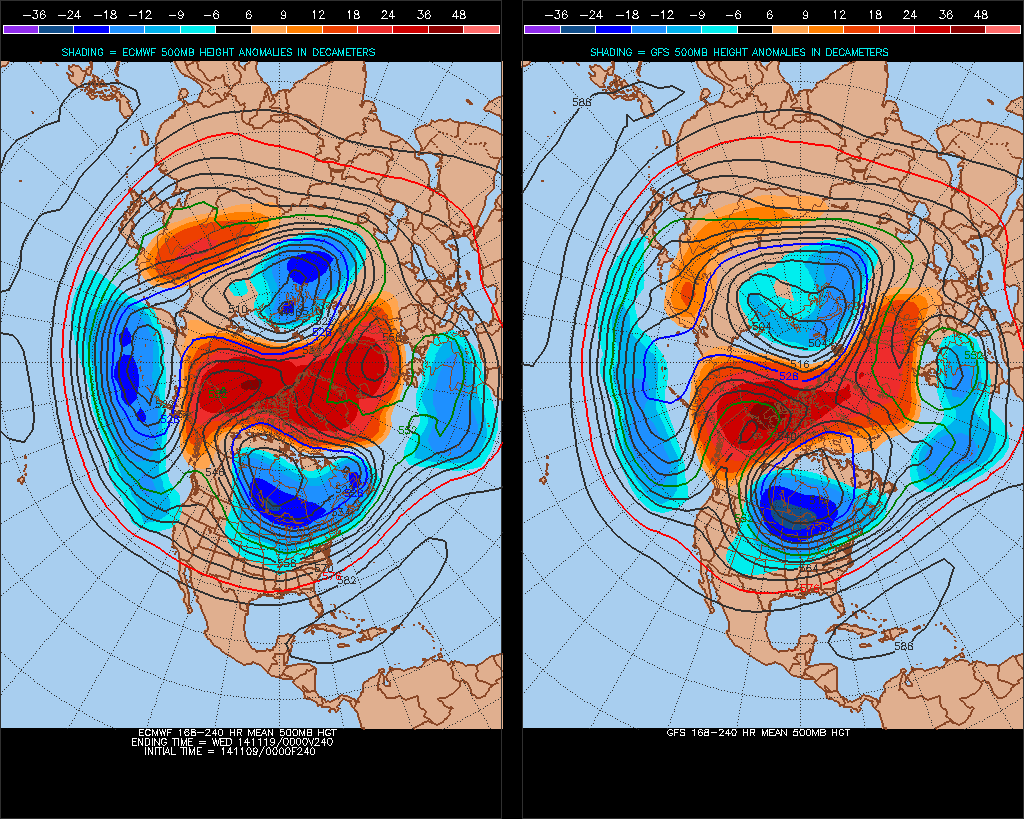
A cool morning in NW Harris County with temperatures is the mid to upper 40's will warm up to the comfortable 70's today under sunny skies. Tomorrow will continue to warm as we begin to feel the response to the much advertised pattern change to a much colder pattern by Tuesday evening across the Lone Star State and much of North America. We are expecting a Omega Blocking Pattern that has several feature involved. Extratropical Storm Nuri played an important role in beginning the process of buckling the jet stream across N America, but other factors are in play such as tropical forcing, a robust Madden-Julian Oscillation (MJO) as well as rather strong Convectively Coupled Kelvin Wave (cckw) across the Pacific. At the High Latitudes across the North Pole and Arctic, very strong High Pressure extends across that area known as an Omega Block. Ridging in Alaska allows very cold air that has been building across Eurasia/Siberia to be pulled across the N Pole and plunge very far S into the United States and even Mexico. The blocking pattern extends into the NE Atlantic Ocean that does not allow the cold air to move E that far off the E Coast into the Atlantic as wee typically see in Winter. The main issue is this blocking regime does not appear to be transient and will be in place into the extended range that may well last into the week of Thanksgiving. If this blocking pattern persists, reinforcing shots of very cold air will continue to drop S in fairly rapid progression with the arrival of additional fronts about every 4-5 days. The main concerns are the embedded upper air disturbances under cutting the Western Ridge as well as those dropping S from Western Canada. Add to the mix a noisy sub tropical jet with over running moisture and upglide precipitation and you have a recipe for a very complicated forecast that is typical of a weak El Nino year. There will be periods of moderation, but the appear to be very short lived and the disturbances cross the Inter Mountain West and Plains will begin to lay down snow leading to less and less airmass modification as time goes on.

Image

EXTENDED FORECAST DISCUSSION
NWS WEATHER PREDICTION CENTER COLLEGE PARK MD
1234 AM EST SUN NOV 09 2014

VALID 12Z WED NOV 12 2014 - 12Z SUN NOV 16 2014

...RELOADING UPPER PATTERN TO CONTINUE TROUGHING/COLD OVER MOST OF
THE CONUS...

...OVERVIEW...

WELL-ADVERTISED COLD SNAP WILL LEAD THE MEDIUM RANGE PERIOD
MIDWEEK NEXT WEEK AS STRONG RIDGING /500MB HEIGHT STND ANOMALY
NEARING +4 WHICH IS VERY RARE/ HOLDS OVER NORTHWESTERN NORTH
AMERICA. THIS FAVORS TROUGHING TO ITS SOUTHWEST AND SOUTHEAST IN
AN OMEGA BLOCK PATTERN... LOCKING IN THE COLD FOR MOST OF THE
CONUS OUTSIDE THE WEST COAST BUT PARTICULARLY FOCUSED OVER THE
CENTRAL STATES.

...GUIDANCE PREFERENCES...

SYNOPTIC AGREEMENT REMAINS GOOD AMONG THE 18Z PARALLEL GFS AND 12Z
ECMWF/ECENS MEAN... AND THEIR BLEND WAS USED AS THE BASE TO THE
FORECAST. THE DETAILS TO BE IRONED OUT LIE WITH THE EXODUS SPEED
OF THE UPPER TROUGH THROUGH THE NORTHEAST ON FRIDAY /WHERE THE
ECMWF MAY BE OVERLY WRAPPED UP/ AND ALSO THE STRENGTH OF THE RIDGE
ALONG THE WEST COAST UP INTO ALASKA. ECMWF ENSEMBLE MEMBERS
SUGGEST A STRONGER AND MORE RESILIENT RIDGE THAN THE GEFS MEMBERS
AND GIVEN THE LEAD-IN WAS INCLINED TO SIDE WITH MORE RIDGING
UPSTREAM WHICH SUPPORTS MORE DIGGING DOWNSTREAM INTO THE ROCKIES
BY THE END OF NEXT WEEKEND. 12Z GFS WAS NOT TOO FAR FROM THIS
CLUSTER OF SOLUTIONS AS WELL. THIS WOULD SUPPORT CYCLOGENESIS IN
THE UPPER MS VALLEY BY SUNDAY.


...SENSIBLE WEATHER HIGHLIGHTS...

PRECIP WILL FOCUS ALONG/AHEAD OF THE ARCTIC BOUNDARY PUSHING OFF
THE EAST COAST ON WEDNESDAY AND ALSO BACK THROUGH THE ROCKIES
WHERE THE COLD AIR WILL SPUTTER OVER THE DIVIDE. LAKE-EFFECT SNOW
SHOULD FLY IN EARNEST WITH NW FLOW OVER THE REGION AND A SFC-850
DELTA T OF ABOUT 15-20C. ENERGY THAT WILL SLIP BETWEEN THE RIDGE
CENTERS WILL SERVE AS THE MAIN PRECIP AREA WED-THU AS IT PUSHES
INTO OREGON AND NORTHERN CALIFORNIA. THE COLD TEMPERATURES REMAIN
THE TOP STORY WITH 30-40F BELOW AVERAGE TEMPERATURES POSSIBLE FROM
MT SOUTHEASTWARD AND EVEN 20-30F BELOW AVERAGE INTO TEXAS. SOME
RECORD LOW MINS/MAXES ARE POSSIBLE. SECONDARY SURGE NEXT WEEKEND
SHOULD BE INTERRUPTED BY BRIEF MODERATION BUT STILL COLDER THAN
AVERAGE FOR MID-NOVEMBER.


FRACASSO


The forecast late in the week is already presenting some challenges as a fairly strong upper air disturbance arrives from the Western US into the Southern Rockies/Southern Plains. There are some indications that a wave of low pressure may develop along the Lower Texas Gulf Coast and spread moisture over a shallow Arctic airmass at the surface. The best chance for wintry mischief will be across the Panhandle and Oklahoma and on E into Arkansas. As always we cannot not accurately predict what the sensible weather will be beyond the day 2 to 4 day range and as we know, that can even be challenging.

Image
0 likes   
Carla/Alicia/Jerry(In The Eye)/Michelle/Charley/Ivan/Dennis/Katrina/Rita/Wilma/Ike/Harvey

Member: National Weather Association
Wx Infinity Forums
http://wxinfinity.com/index.php

Facebook.com/WeatherInfinity
Twitter @WeatherInfinity

Ralph's Weather
S2K Supporter
S2K Supporter
Posts: 3269
Age: 38
Joined: Fri Dec 13, 2013 11:55 am
Location: Lindale, TX
Contact:

#996 Postby Ralph's Weather » Sun Nov 09, 2014 10:12 am

Another great discussion srainhoutx. We are in for some very interesting weather over the next few weeks. The first thing will be to watch ad the models start to get a handle on late this week. It will likely be just light rain here, but there is also the chance that there will be more cold air involved which could lead to mischief. This early in the winter I expect it to be all rain though.
0 likes   
Follow on Facebook at Ralph's Weather.

User avatar
Ntxw
Storm2k Moderator
Storm2k Moderator
Posts: 22784
Joined: Wed Oct 21, 2009 6:34 pm
Location: DFW, Texas

#997 Postby Ntxw » Sun Nov 09, 2014 10:33 am

The blocking in NW Canada and Alaska is progged to reach some 4-5 deviations below normal. That would be a tanking -EPO ridge of equal magnitude usually 3-4 is typically record breaking. We'll have to see, 3 SD's is pretty much a lock. There's only a handful of times we've had such blocking there that stayed around.
0 likes   
The above post and any post by Ntxw is NOT an official forecast and should not be used as such. It is just the opinion of the poster and may or may not be backed by sound meteorological data. It is NOT endorsed by any professional institution including Storm2k. For official information, please refer to NWS products.


  Help support Storm2K!

Help Support Storm2K


User avatar
dhweather
S2K Supporter
S2K Supporter
Posts: 6199
Joined: Sat Aug 14, 2004 9:29 pm
Location: Heath, TX
Contact:

#998 Postby dhweather » Sun Nov 09, 2014 11:10 am

The next couple of weeks will be interesting to watch. If we had a true el-nino event going on (I'm just not sold it is/will happen), there would likely be multiple shots of getting wintry precip.
0 likes   
The above post and any post by dhweather is NOT an official forecast and should not be used as such. It is just the opinion of the poster and may or may not be backed by sound meteorological data. It is NOT endorsed by any professional institution including storm2k.org. For official information, please refer to NWS products.

aggiecutter
Category 5
Category 5
Posts: 1753
Joined: Thu Oct 14, 2004 9:22 pm
Location: Texarkana

Re: Texas Fall-2014

#999 Postby aggiecutter » Sun Nov 09, 2014 12:11 pm

The last several runs of the models are backing off the secondary surge of arctic air next weekend. Looks like a cold Thursday-Saturday, with a moderation trend continuing until the middle of the following week. After that, the models hint at another surge arctic air. However, at this time, I don't see anything that would rival November 76 as far as cold is concerned. Highs in the low 40's and lows either side of 30 is cold for this time of year, but November of 76 had several instances of highs in the low 30's and lows in the mid and lower teens. I don't see anything close to that in the foreseeable future.


I am not a pro-met and take my forecast with a grain of salt.
0 likes   

User avatar
Ntxw
Storm2k Moderator
Storm2k Moderator
Posts: 22784
Joined: Wed Oct 21, 2009 6:34 pm
Location: DFW, Texas

#1000 Postby Ntxw » Sun Nov 09, 2014 12:15 pm

Dont be so sure on temps with models. -EPO beats them every time, never fails
0 likes   
The above post and any post by Ntxw is NOT an official forecast and should not be used as such. It is just the opinion of the poster and may or may not be backed by sound meteorological data. It is NOT endorsed by any professional institution including Storm2k. For official information, please refer to NWS products.


  Help support Storm2K!

Help Support Storm2K


Return to “USA & Caribbean Weather”

Who is online

Users browsing this forum: JDawg512, txtwister78 and 11 guests