Texas Fall-2014
Moderator: S2k Moderators
Forum rules

The posts in this forum are NOT official forecast and should not be used as such. They are just the opinion of the poster and may or may not be backed by sound meteorological data. They are NOT endorsed by any professional institution or STORM2K.
-
Portastorm

- Storm2k Moderator

- Posts: 9955
- Age: 63
- Joined: Fri Jul 11, 2003 9:16 am
- Location: Round Rock, TX
- Contact:
Re: Texas Fall-2014
aggiecutter is right about how the 0z models looked ... but I just checked out the 12z GFS run and it reverses what the 0z run showed and pretty much keeps us locked down into below normal/much below normal temps over its 384-hour run.
0 likes
Any forecasts under my name are to be taken with a grain of salt. Get your best forecasts from the National Weather Service and National Hurricane Center.
-
aggiecutter
- Category 5

- Posts: 1755
- Joined: Thu Oct 14, 2004 9:22 pm
- Location: Texarkana
Re: Texas Fall-2014
Portastorm wrote:aggiecutter is right about how the 0z models looked ... but I just checked out the 12z GFS run and it reverses what the 0z run showed and pretty much keeps us locked down into below normal/much below normal temps over its 384-hour run.
I saw the 12Z run of the GFS. However, I didn't see anything that would lead me to believe that November 76 type of cold is coming for the next week. I see a overall pattern that is cold, but not 76 cold.
0 likes

Re: Texas Fall-2014
I just hope we don't use up the pattern for the rest of the winter.. imagine if this was in January hehe. it is a very impressive length of cold air advection, seems to have some staying power if the models are right. Remember when we had those years when the big arctic blast was always in the future. This year, the big warm up may always be showing in future model runs but not really materializing.
0 likes
-
srainhoutx

- S2K Supporter

- Posts: 6919
- Age: 68
- Joined: Sun Jan 14, 2007 11:34 am
- Location: Haywood County, NC
- Contact:
Re: Texas Fall-2014
Portastorm and I have been chatting since late last week about the upcoming pattern and what it may mean as we progress into early/mid Winter. The are some indications that the pattern that developing so soon may not be transient and for those that would like to read a bit more technical discussion from some research being done by Judah Cohen, Ph.D., and Jason Furtado, Ph.D., who work at Atmospheric and Environmental Research (AER), a division of Verisk Climate. This was released on Friday and is a great read about the Arctic Oscillation, ENSO, PDO state and a potential early season SSW event developing and how it may impact our sensible weather as far South as our part of the World....
http://www.aer.com/science-research/cli ... scillation
Edit to add the 12Z GGEM and Euro are much different in their solutions suggested yesterday and overnight with much colder air across much of North America and embedded shortwaves adding to the developing snow cover across the Plains suggesting increasing odds of less airmass modification and insolation increasing. We have to start building that snow cover across the Lower 48 and it is beginning to look like the pattern will reload. Stepping down as I like to say as an analogy with each intrusion of Arctic air.
0 likes
Carla/Alicia/Jerry(In The Eye)/Michelle/Charley/Ivan/Dennis/Katrina/Rita/Wilma/Ike/Harvey
Member: National Weather Association
Wx Infinity Forums
http://wxinfinity.com/index.php
Facebook.com/WeatherInfinity
Twitter @WeatherInfinity
Member: National Weather Association
Wx Infinity Forums
http://wxinfinity.com/index.php
Facebook.com/WeatherInfinity
Twitter @WeatherInfinity

12z Euro is back to mischief, the cold air is a lock but any disturbances or digging trough out west has not been consistent on them be wary.
0 likes
The above post and any post by Ntxw is NOT an official forecast and should not be used as such. It is just the opinion of the poster and may or may not be backed by sound meteorological data. It is NOT endorsed by any professional institution including Storm2k. For official information, please refer to NWS products.
Help support Storm2K!
-
Ralph's Weather
- S2K Supporter
- Posts: 3371
- Age: 38
- Joined: Fri Dec 13, 2013 11:55 am
- Location: Lindale, TX
- Contact:
This is one of the times that we are better off going on the atmospheric setup and just use models as a tool to see what the sensible affects of those conditions may be. When the EPO goes negative the the cold air usually makes it farther south and with more intensity than the models depict as we saw many times last year.
0 likes
Follow on Facebook at Ralph's Weather.
-
aggiecutter
- Category 5
- Posts: 1755
- Joined: Thu Oct 14, 2004 9:22 pm
- Location: Texarkana
Re: Texas Fall-2014
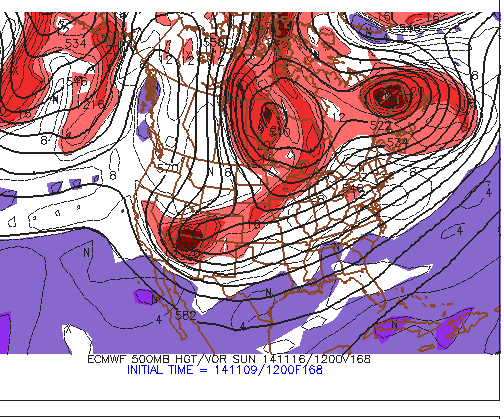
Now this looks impressive for the following week. After that vort max ejects out from the 4 corners area, that should bring down some very cold air into the southern plains.

0 likes
-
srainhoutx
- S2K Supporter
- Posts: 6919
- Age: 68
- Joined: Sun Jan 14, 2007 11:34 am
- Location: Haywood County, NC
- Contact:
Re: Texas Fall-2014
Very nice cross Polar flow developing via the Global guidance today in the medium to longer range. Amazing pattern for mid November gang...
0 likes
Carla/Alicia/Jerry(In The Eye)/Michelle/Charley/Ivan/Dennis/Katrina/Rita/Wilma/Ike/Harvey
Member: National Weather Association
Wx Infinity Forums
http://wxinfinity.com/index.php
Facebook.com/WeatherInfinity
Twitter @WeatherInfinity
Member: National Weather Association
Wx Infinity Forums
http://wxinfinity.com/index.php
Facebook.com/WeatherInfinity
Twitter @WeatherInfinity
Re: Texas Fall-2014
hriverajr wrote:I just hope we don't use up the pattern for the rest of the winter.. imagine if this was in January hehe. it is a very impressive length of cold air advection, seems to have some staying power if the models are right. Remember when we had those years when the big arctic blast was always in the future. This year, the big warm up may always be showing in future model runs but not really materializing.
I know you may have said this in jest but there is something to it. The pattern is very stable and hard to breakdown. The Aleutian low is the key, heights in that region for weeks and months have been quite low, that is why Nuri was allowed to bomb out there. I think that is the dominant feature this season, typical of El Nino. It will be tough to break and if so won't break for long. The base state for the past 12 months is colder.
0 likes
The above post and any post by Ntxw is NOT an official forecast and should not be used as such. It is just the opinion of the poster and may or may not be backed by sound meteorological data. It is NOT endorsed by any professional institution including Storm2k. For official information, please refer to NWS products.
Help support Storm2K!
Help support Storm2K!
-
srainhoutx
- S2K Supporter
- Posts: 6919
- Age: 68
- Joined: Sun Jan 14, 2007 11:34 am
- Location: Haywood County, NC
- Contact:
Re: Texas Fall-2014
Afternoon briefing from Jeff:
Prolonged period of below to well below normal temperatures heading for much of the central and eastern US this week including TX.
Surface high pressure is gradually moving eastward this afternoon with surface winds swinging around to the south and southwest over the area. Winds will increase from the south on Monday and this will result in a fairly warm day with highs in the 70’s across much of the area. Monday will be the last day of highs in the 70’s likely for the next 10-15 days across the region.
US upper air pattern will undergo significant amplification along the US west coast into western Canada and blocking over the Atlantic Ocean in response to the extremely intense extra-tropical cyclone (ex-super typhoon Nuri remains) over the northern Pacific Ocean. Significant ridging along the west coast will dislodge a pool of cold polar air in NW Canada and send in quickly down the front range of the Rockies early this week. The trough being carved out downstream of the ridge over the central US is fairly significant for mid-November with below mid-level heights on the order of 2-3 standard deviations from normal. This will result in a strong polar air mass reaching the US Gulf coast and by Tuesday. Powerful cold front will enter TX Monday evening and sweep quickly off the TX coast Tuesday. Temperatures ahead of the front will be in the 70’s and fall quickly into the 50’s and even 40’s behind the front. Moisture looks fairly meager with the boundary and while forcing will be strong, will not go any higher than 30% for a line of showers mainly toward the coast.
Gusty north winds and strong cold air advection will be in place Tuesday night into Wednesday. Some of the guidance is suggesting a period of about 12-24 hours of weak overrunning clouds as WSW mid-level flow brings moisture over top of the surface cold dome. Any cloud cover will have effects on daytime highs and overnight lows. It is possible that coastal locations could remain mostly cloudy on Wednesday with highs staying in the 50’s. Overrunning regime should end Thursday as deep polar high builds into TX. Clearing skies and lighter winds will result in near excellent cooling conditions Thursday night. With dewpoints in the upper 20’s to lower 30’s a few locations north of I-10 will likely fall to freezing. GFS guidance is showing a low of 29 for Conroe, 32 for College Station, and 35 for IAH Friday morning. Will need to watch this period very closely to see if more widespread freezing conditions are possible. Freezing conditions are likely Friday morning across much of central and north TX.
Cold air will remain locked in place into next week as downstream blocking in the upper air pattern over the Atlantic keeps cold fronts moving southward preventing air mass modification. Undercutting sub-tropical flow and position of the polar highs suggest a fairly potent short wave drops through the mean trough next weekend. With cold air locked in place at the surface mid level moisture will begin to overrun the cold dome on Saturday resulting in increasing clouds and by late afternoon showers developing from SW to NE across the region. Latest GFS run is very aggressive in moisture return late Saturday. Coastal troughing is possible Saturday night into Sunday with rain chances increasing as moisture pours into and over the cold air mass at the surface. This will likely result in very raw conditions by Sunday with highs likely not getting much above 50 with clouds and rainfall. There is some potential for P-type concerns over W/NW/N TX late next weekend where the air will be colder, but all rain for SE TX.
Departing storm system early next week potentially grabs a batch of arctic air over Canada and brings it southward down the plains keeping cold conditions in place through Thanksgiving week as downstream blocking remains in place over the Atlantic.
0 likes
Carla/Alicia/Jerry(In The Eye)/Michelle/Charley/Ivan/Dennis/Katrina/Rita/Wilma/Ike/Harvey
Member: National Weather Association
Wx Infinity Forums
http://wxinfinity.com/index.php
Facebook.com/WeatherInfinity
Twitter @WeatherInfinity
Member: National Weather Association
Wx Infinity Forums
http://wxinfinity.com/index.php
Facebook.com/WeatherInfinity
Twitter @WeatherInfinity
-
somethingfunny

- ChatStaff

- Posts: 3926
- Age: 37
- Joined: Thu May 31, 2007 10:30 pm
- Location: McKinney, Texas
Re: Texas Fall-2014

I love these silly snow maps
0 likes
I am not a meteorologist, and any posts made by me are not official forecasts or to be interpreted as being intelligent. These posts are just my opinions and are probably silly opinions.
-
Portastorm
- Storm2k Moderator
- Posts: 9955
- Age: 63
- Joined: Fri Jul 11, 2003 9:16 am
- Location: Round Rock, TX
- Contact:
Re: Texas Fall-2014
This board would explode if that happened!
0 likes
Any forecasts under my name are to be taken with a grain of salt. Get your best forecasts from the National Weather Service and National Hurricane Center.
-
Wntrwthrguy
- Tropical Storm

- Posts: 161
- Joined: Thu Nov 21, 2013 8:48 pm
- Location: North Austin
Re: Texas Fall-2014
Portastorm wrote::uarrow:
This board would explode if that happened!
So you're saying there's a chance?
0 likes
Any post should not be taken as a forecast. I am just an amateur living the dream.
-
TheProfessor

- Professional-Met

- Posts: 3506
- Age: 29
- Joined: Tue Dec 03, 2013 10:56 am
- Location: Wichita, Kansas
-
Tireman4

- S2K Supporter
- Posts: 5903
- Age: 60
- Joined: Fri Jun 30, 2006 1:08 pm
- Location: Humble, Texas
- Contact:
Re: Texas Fall-2014
Portastorm wrote::uarrow:
This board would explode if that happened!
Somehow, Wxman 57 is either biking right now ( I betcha he is!!) or not enthused at all at those maps...
0 likes
-
TheProfessor
- Professional-Met
- Posts: 3506
- Age: 29
- Joined: Tue Dec 03, 2013 10:56 am
- Location: Wichita, Kansas
-
TeamPlayersBlue

- Category 5
- Posts: 3530
- Joined: Tue Feb 02, 2010 1:44 am
- Location: Denver/Applewood, CO
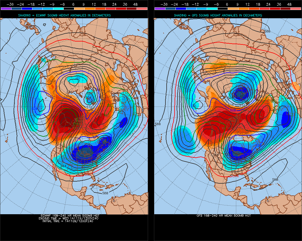
One thing about this outbreak, while this high is absolutely massive, especially for this time of year, but the trough on the 500 MB chart does 'dig' as far south as it could. Notice how the initial high shifts east after it hits the plains. Correct me if im wrong mets. It could be colder if the high crashed straight down into the central texas region but it doesnt make it that far. Like Ntx said though, the -EPO can provide surprises.
Ive noticed that a big low around the Aleutians will be key this year, this brings blocking to the Polar region.
Ive noticed that a big low around the Aleutians will be key this year, this brings blocking to the Polar region.
0 likes
Personal Forecast Disclaimer:
The posts in this forum are NOT official forecast and should not be used as such. They are just the opinion of the poster and may or may not be backed by sound meteorological data. They are NOT endorsed by any professional institution or storm2k.org. For official information, please refer to the NHC and NWS products.
The posts in this forum are NOT official forecast and should not be used as such. They are just the opinion of the poster and may or may not be backed by sound meteorological data. They are NOT endorsed by any professional institution or storm2k.org. For official information, please refer to the NHC and NWS products.
Time to look upstream, aside from all the indexes (yes all of them) tanking lets have a look at source region. The coldest air at the surface in the Northern Hemisphere is currently settling into North Central/Western Canada.

And here comes the Arctic High that is going to intensify

And here comes the Arctic High that is going to intensify
0 likes
The above post and any post by Ntxw is NOT an official forecast and should not be used as such. It is just the opinion of the poster and may or may not be backed by sound meteorological data. It is NOT endorsed by any professional institution including Storm2k. For official information, please refer to NWS products.
Help support Storm2K!
Help support Storm2K!
-
aggiecutter
- Category 5
- Posts: 1755
- Joined: Thu Oct 14, 2004 9:22 pm
- Location: Texarkana
Re: Texas Fall-2014
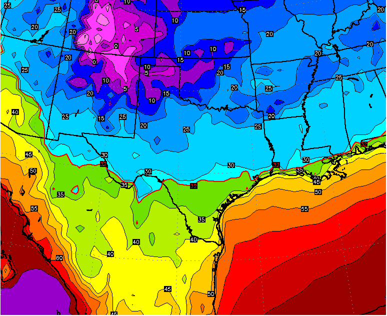
Meteorologist Todd Warren of NBC 6 in Shreveport just posted this on his Facebook: The map is from his Future Cast Weather Model. The map is for lows Tuesday night the 17th of November.
Todd Warren NBC 6
about an hour ago
Still looking at a big blast of Arctic air that begins to arrive next weekend and will be firmly in place by the first of next week. Here is one model's depiction of Monday's high temperatures (30s & low 40s) and Tuesday's low temperatures (10s & 20s). Still looks like lots of rain on the way next weekend. We will have to watch the end of this event as some models indicate that winter precip will be possible. Stay Tuned!

0 likes
Return to “USA & Caribbean Weather”
Who is online
Users browsing this forum: snownado and 45 guests