Texas Fall-2014

U.S. & Caribbean Weather Discussions and Severe Weather Events

Moderator: S2k Moderators

Forum rules

The posts in this forum are NOT official forecast and should not be used as such. They are just the opinion of the poster and may or may not be backed by sound meteorological data. They are NOT endorsed by any professional institution or STORM2K.

Help Support Storm2K
Message
Author
weatherdude1108
Category 5
Category 5
Posts: 4228
Joined: Tue Dec 13, 2011 1:04 pm
Location: Northwest Austin/Cedar Park, TX

#1041 Postby weatherdude1108 » Mon Nov 10, 2014 10:22 am

I've lived in south central Texas for 38 years. During that time, I can't recall a time when there was a threat of freezing temperatures this early in the season (early to mid-November). I may be wrong.

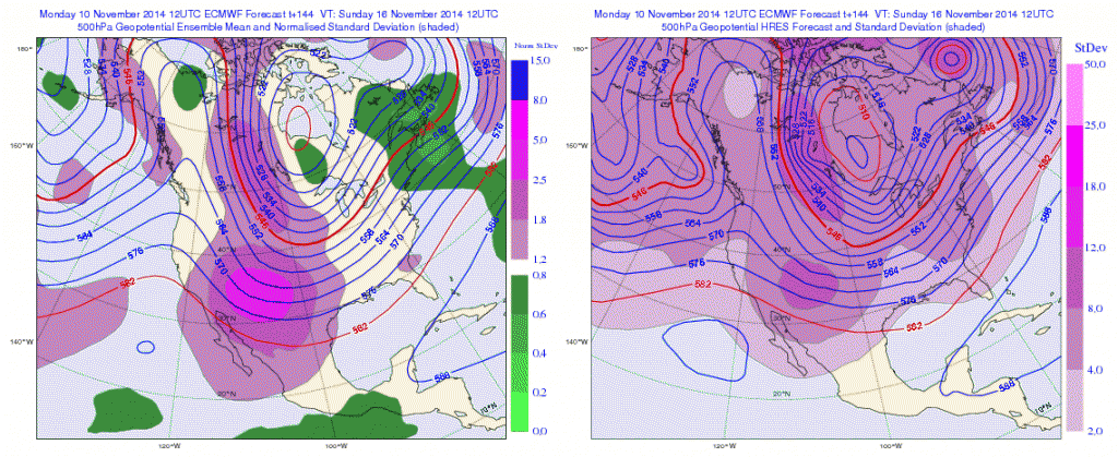
Superstorm Nuri's nudging of the jet stream is having a Butterfly Effect of historic proportions it seems(?). A lot of awesome write-ups on this thread, over half of which I know not much, if anything, about (example: teleconnections of 5?).

Anyway, I'm just honored to read all of it and try to learn from it. Wealth of knowledgeable people here! :D

SPECIAL WEATHER STATEMENT
NATIONAL WEATHER SERVICE AUSTIN/SAN ANTONIO TX
616 AM CST MON NOV 10 2014

TXZ171>173-183>194-202>209-217>225-228-102100-
LLANO-BURNET-WILLIAMSON-VAL VERDE-EDWARDS-REAL-KERR-BANDERA-
GILLESPIE-KENDALL-BLANCO-HAYS-TRAVIS-BASTROP-LEE-KINNEY-UVALDE-
MEDINA-BEXAR-COMAL-GUADALUPE-CALDWELL-FAYETTE-MAVERICK-ZAVALA-
FRIO-ATASCOSA-WILSON-KARNES-GONZALES-DE WITT-LAVACA-DIMMIT-
INCLUDING THE CITIES OF...LLANO...BURNET...GEORGETOWN...DEL RIO...
ROCKSPRINGS...LEAKEY...KERRVILLE...BANDERA...FREDERICKSBURG...
BOERNE...BLANCO...SAN MARCOS...AUSTIN...BASTROP...GIDDINGS...
BRACKETTVILLE...UVALDE...HONDO...SAN ANTONIO...NEW BRAUNFELS...
SEGUIN...LOCKHART...LA GRANGE...EAGLE PASS...CRYSTAL CITY...
PEARSALL...PLEASANTON...FLORESVILLE...KARNES CITY...GONZALES...
CUERO...HALLETTSVILLE...CARRIZO SPRINGS
616 AM CST MON NOV 10 2014

...MUCH COLDER TEMPERATURES TUESDAY THROUGH FRIDAY WITH THE FIRST
FREEZE OF THE SEASON POSSIBLE IN SOME AREAS LATER THIS WEEK...

A STRONG COLD FRONT WILL MOVE THROUGH SOUTH-CENTRAL TEXAS TUESDAY
MORNING. AHEAD OF THE FRONT TODAY...WARM TEMPERATURES IN THE UPPER
70S TO LOW 80S AND A BREEZY SOUTH WIND.

BEHIND THE COLD FRONT...TEMPERATURES WILL FALL TUESDAY AFTERNOON
INTO THE 40S ACROSS THE HILL COUNTRY AND CENTRAL TEXAS AND INTO
THE 50S ACROSS SOUTHERN AREAS. BY WEDNESDAY MORNING TEMPERATURES
WILL DIP INTO THE MID AND UPPER 30S ACROSS THE HILL COUNTRY AND
LOW 40S ELSEWHERE. HIGHS ON WEDNESDAY WILL ONLY BE IN THE LOW TO
MID 50S....WITH IT FEELING EVEN COLDER WITH A BRISK NORTH WIND.

EVEN COLDER TEMPERATURES ARE EXPECTED THURSDAY...WITH LOWS ACROSS
SOME LOCATIONS IN THE NORTHERN HILL COUNTRY POSSIBLY DIPPING TO
THE FREEZING MARK...AND UPPER 30S TO LOW 40S ELSEWHERE. HIGHS ON
THURSDAY WILL RANGE FROM THE MID AND UPPER 40S ACROSS THE HILL
COUNTRY AND CENTRAL TEXAS TO LOW 50S ACROSS SOUTHERN AREAS.

AT THIS TIME...FREEZING TEMPERATURES OF 28 TO 32 DEGREES ARE
EXPECTED FRIDAY MORNING ALONG AND NORTH OF A ROCKSPRINGS TO MEDINA
TO BOERNE TO JOHNSON CITY TO KILLEEN LINE. THERE IS THE
POSSIBILITY OF THIS LINE BEING EXTENDED SLIGHTLY FARTHER SOUTH IN
THE COMING DAYS...AS MODELS HAVE BEEN TRENDING COLDER.
SOUTH OF
THE LINE LOW TEMPERATURES IN THE MID 30S TO AROUND 40 ARE
EXPECTED. HIGHS ON FRIDAY WILL ONLY BE IN THE LOW TO MID 50S.

SLIGHTLY WARMER TEMPERATURES ARE EXPECTED OVER THE WEEKEND...ALONG WITH
A SLIGHT CHANCE OF RAIN.


$$
0 likes   
The preceding post is NOT an official forecast, and should not be used as such. It is only the opinion of the poster and may or may not be backed by sound meteorological data. It is NOT endorsed by any professional institution including storm2k.org. For Official Information please refer to the NHC and NWS products.

BrokenGlassRepublicn
Category 1
Category 1
Posts: 481
Joined: Sun Nov 20, 2011 8:07 pm
Location: Richardson, Texas

Re: Texas Fall-2014

#1042 Postby BrokenGlassRepublicn » Mon Nov 10, 2014 10:50 am

dhweather wrote:
wxman57 wrote:Latest runs of the GFS (even the parallel run) are losing the cold air by next Saturday, at least across SE TX. They are now showing a slow warm-up back to the 70s next week. Euro says "nope" and indicates freezing temps for SE TX next week. It's common for the GFS to lose the cold air in the 5-10 day time frame.


The GFS always struggles badly with cold weather. Hopefully V2 is better with it.


I was going to ask the same thing...with the reported changes/upgrades to GFS model, can we trust those same model tendancies this winter?
0 likes   

Ralph's Weather
S2K Supporter
S2K Supporter
Posts: 3269
Age: 38
Joined: Fri Dec 13, 2013 11:55 am
Location: Lindale, TX
Contact:

Re: Texas Fall-2014

#1043 Postby Ralph's Weather » Mon Nov 10, 2014 10:57 am

BrokenGlassRepublicn wrote:
dhweather wrote:
wxman57 wrote:Latest runs of the GFS (even the parallel run) are losing the cold air by next Saturday, at least across SE TX. They are now showing a slow warm-up back to the 70s next week. Euro says "nope" and indicates freezing temps for SE TX next week. It's common for the GFS to lose the cold air in the 5-10 day time frame.


The GFS always struggles badly with cold weather. Hopefully V2 is better with it.


I was going to ask the same thing...with the reported changes/upgrades to GFS model, can we trust those same model tendancies this winter?


I expect this will be something we will have to watch and learn as the winter goes. All models are going to have biases, but hopefully they have fixed that one.
0 likes   
Follow on Facebook at Ralph's Weather.

User avatar
srainhoutx
S2K Supporter
S2K Supporter
Posts: 6919
Age: 67
Joined: Sun Jan 14, 2007 11:34 am
Location: Haywood County, NC
Contact:

Re: Texas Fall-2014

#1044 Postby srainhoutx » Mon Nov 10, 2014 11:26 am

Already seeing some subtle differences in regard the 12Z GFS ~vs~ the parallel version. The parallel is 'sniffing' a bit stronger shortwave dropping SE from the Pacific NW and a stronger high building in from Canada this weekend. Flip flopping right along.
0 likes   
Carla/Alicia/Jerry(In The Eye)/Michelle/Charley/Ivan/Dennis/Katrina/Rita/Wilma/Ike/Harvey

Member: National Weather Association
Wx Infinity Forums
http://wxinfinity.com/index.php

Facebook.com/WeatherInfinity
Twitter @WeatherInfinity

Jarodm12
Category 1
Category 1
Posts: 337
Joined: Sat Jan 29, 2011 8:05 pm

Re: Texas Fall-2014

#1045 Postby Jarodm12 » Mon Nov 10, 2014 11:30 am

Wonder what the euro is going to say, the model spread is significant at 132 hrs. Would be nice if temps were forecast lower. Obviously details need to be refined but i hopeful north texas may see a flake this weekend in monday, you can always hope.
0 likes   

texas1836
Tropical Storm
Tropical Storm
Posts: 223
Age: 55
Joined: Fri Aug 17, 2012 10:10 am
Location: Ruidoso, New Mexico

#1046 Postby texas1836 » Mon Nov 10, 2014 12:10 pm

Looks like our front is gaining ground in Kansas. Might hit McKinney by midnight.
0 likes   

Ralph's Weather
S2K Supporter
S2K Supporter
Posts: 3269
Age: 38
Joined: Fri Dec 13, 2013 11:55 am
Location: Lindale, TX
Contact:

Re:

#1047 Postby Ralph's Weather » Mon Nov 10, 2014 12:27 pm

texas1836 wrote:Looks like our front is gaining ground in Kansas. Might hit McKinney by midnight.


These intense fronts always seem to come faster than forecasted. The temp drops around Denver are very impressive.
0 likes   
Follow on Facebook at Ralph's Weather.

User avatar
opticsguy
S2K Supporter
S2K Supporter
Posts: 230
Joined: Wed Jan 05, 2011 9:27 pm
Location: McKinney, TX

Re: Texas Fall-2014

#1048 Postby opticsguy » Mon Nov 10, 2014 1:17 pm

Where does one find this new GFS output?
0 likes   

User avatar
South Texas Storms
Professional-Met
Professional-Met
Posts: 4226
Joined: Thu Jun 24, 2010 12:28 am
Location: Houston, TX

Re: Texas Fall-2014

#1049 Postby South Texas Storms » Mon Nov 10, 2014 1:47 pm

opticsguy wrote:Where does one find this new GFS output?


Here you go: http://www.tropicaltidbits.com/analysis/models/gfsp/
0 likes   

User avatar
gatorcane
S2K Supporter
S2K Supporter
Posts: 23691
Age: 47
Joined: Sun Mar 13, 2005 3:54 pm
Location: Boca Raton, FL

#1050 Postby gatorcane » Mon Nov 10, 2014 2:20 pm

12Z ECMWF continues to show the coldest anomalies impacting impacting the Texas Panhandle and points north with the coldest anomalies shifting east and staying well north of SE Texas and the Southern Gulf coast

72, 96, and 120 hour graphics below:
Image
Image
Image
Last edited by gatorcane on Mon Nov 10, 2014 2:26 pm, edited 7 times in total.
0 likes   

User avatar
vbhoutex
Storm2k Executive
Storm2k Executive
Posts: 29112
Age: 73
Joined: Wed Oct 09, 2002 11:31 pm
Location: Cypress, TX
Contact:

Re:

#1051 Postby vbhoutex » Mon Nov 10, 2014 2:21 pm

texas1836 wrote:Looks like our front is gaining ground in Kansas. Might hit McKinney by midnight.

Right now it is looking anywhere from 3 - 8 hrs ahead of schedule depending on if it accelerates any more. That was even noted in the Houston AFD this am. The models generally do not do well with these major cold snaps and their depths and the temps. It will be interesting to see what happens. :cold: :froze:
0 likes   
Skywarn, C.E.R.T.
Please click below to donate to STORM2K to help with the expenses of keeping the site going:
Image

User avatar
gatorcane
S2K Supporter
S2K Supporter
Posts: 23691
Age: 47
Joined: Sun Mar 13, 2005 3:54 pm
Location: Boca Raton, FL

Re: Texas Fall-2014

#1052 Postby gatorcane » Mon Nov 10, 2014 2:29 pm

wxman57 wrote:Latest runs of the GFS (even the parallel run) are losing the cold air by next Saturday, at least across SE TX. They are now showing a slow warm-up back to the 70s next week. Euro says "nope" and indicates freezing temps for SE TX next week. It's common for the GFS to lose the cold air in the 5-10 day time frame.


Euro seems to have backed off on the freezing temperatures for SE Texas next week, per the 12Z run.
0 likes   

Stormcenter
S2K Supporter
S2K Supporter
Posts: 6684
Joined: Wed Sep 03, 2003 11:27 am
Location: Houston, TX

Re: Texas Fall-2014

#1053 Postby Stormcenter » Mon Nov 10, 2014 2:33 pm

I wouldn't be surprised if it flip flopped back and forth a few more times.


gatorcane wrote:
wxman57 wrote:Latest runs of the GFS (even the parallel run) are losing the cold air by next Saturday, at least across SE TX. They are now showing a slow warm-up back to the 70s next week. Euro says "nope" and indicates freezing temps for SE TX next week. It's common for the GFS to lose the cold air in the 5-10 day time frame.


Euro seems to have backed off on the freezing temperatures for SE Texas next week, per the 12Z run.
0 likes   

User avatar
TheProfessor
Professional-Met
Professional-Met
Posts: 3506
Age: 28
Joined: Tue Dec 03, 2013 10:56 am
Location: Wichita, Kansas

#1054 Postby TheProfessor » Mon Nov 10, 2014 2:37 pm

There's a quite a bit of snow on the ground up in Minnesota, I might be able to post a picture later, but that should help prevent modification later on if it stays on the ground right?
0 likes   
An alumnus of The Ohio State University.

Your local National Weather Service office is your best source for weather information.

User avatar
srainhoutx
S2K Supporter
S2K Supporter
Posts: 6919
Age: 67
Joined: Sun Jan 14, 2007 11:34 am
Location: Haywood County, NC
Contact:

Re: Texas Fall-2014

#1055 Postby srainhoutx » Mon Nov 10, 2014 2:41 pm

The 12Z Euro has a rather deep low developing around day 8 near Dallas at the 500mb level and the surface. Typically we see the guidance struggle beyond 3-5 days. Tomorrow likely will offer a different solution.
0 likes   
Carla/Alicia/Jerry(In The Eye)/Michelle/Charley/Ivan/Dennis/Katrina/Rita/Wilma/Ike/Harvey

Member: National Weather Association
Wx Infinity Forums
http://wxinfinity.com/index.php

Facebook.com/WeatherInfinity
Twitter @WeatherInfinity

User avatar
Portastorm
Storm2k Moderator
Storm2k Moderator
Posts: 9914
Age: 63
Joined: Fri Jul 11, 2003 9:16 am
Location: Round Rock, TX
Contact:

Re: Texas Fall-2014

#1056 Postby Portastorm » Mon Nov 10, 2014 2:50 pm

srainhoutx wrote:The 12Z Euro has a rather deep low developing around day 8 near Dallas at the 500mb level and the surface. Typically we see the guidance struggle beyond 3-5 days. Tomorrow likely will offer a different solution.


Agreed ... that's why we all need to be looking at the ensemble means as well. Some of those cycle operational runs from both the GFS and Euro can (and often do) vary. Ideally, the ensemble means stay a little more consistent.

I know it's going to be 20-25 degrees below normal later this week in Austin and that cold, cloudy, perhaps wet conditions by the weekend. Beyond that? Remains to be seen.
0 likes   
Any forecasts under my name are to be taken with a grain of salt. Get your best forecasts from the National Weather Service and National Hurricane Center.

weatherdude1108
Category 5
Category 5
Posts: 4228
Joined: Tue Dec 13, 2011 1:04 pm
Location: Northwest Austin/Cedar Park, TX

#1057 Postby weatherdude1108 » Mon Nov 10, 2014 3:12 pm

I don't know if I should post this in the Fall or Winter thread. We had about a month of Fall. Now diving head first into Winter. :flag: :cold: :froze:

Today's forecast solutions indicate another very strong cold front will sweep south across the region next Sunday night into Monday morning bringing another blast of very cold air. This air looks to be as cold, or even colder than the air arriving this week. Today's data indicates the Hill Country and most of Central Texas will see another freeze next Tuesday and Wednesday mornings. The cold pattern is forecast to persist throughout the week with another strong front expected late next week.

I hope everyone takes advantage of today's mild temperatures to complete their cold weather preparations. Tender vegetation and container plants will need to be moved to a warm place. And make sure you have a warm place for your pets as this cold pattern is going to persist for at least the next couple of weeks. Say hello to winter!

Bob


http://www.lcra.org/water/river-and-wea ... ather.aspx
0 likes   
The preceding post is NOT an official forecast, and should not be used as such. It is only the opinion of the poster and may or may not be backed by sound meteorological data. It is NOT endorsed by any professional institution including storm2k.org. For Official Information please refer to the NHC and NWS products.

User avatar
TeamPlayersBlue
Category 5
Category 5
Posts: 3445
Joined: Tue Feb 02, 2010 1:44 am
Location: Denver/Applewood, CO

#1058 Postby TeamPlayersBlue » Mon Nov 10, 2014 3:17 pm

I think the models losing the big shot of cold is something we expect. That timeframe is always iffy for the GFS
0 likes   
Personal Forecast Disclaimer:
The posts in this forum are NOT official forecast and should not be used as such. They are just the opinion of the poster and may or may not be backed by sound meteorological data. They are NOT endorsed by any professional institution or storm2k.org. For official information, please refer to the NHC and NWS products.

User avatar
Portastorm
Storm2k Moderator
Storm2k Moderator
Posts: 9914
Age: 63
Joined: Fri Jul 11, 2003 9:16 am
Location: Round Rock, TX
Contact:

Re:

#1059 Postby Portastorm » Mon Nov 10, 2014 3:23 pm

weatherdude1108 wrote:I don't know if I should post this in the Fall or Winter thread. We had about a month of Fall. Now diving head first into Winter. :flag: :cold: :froze:

Today's forecast solutions indicate another very strong cold front will sweep south across the region next Sunday night into Monday morning bringing another blast of very cold air. This air looks to be as cold, or even colder than the air arriving this week. Today's data indicates the Hill Country and most of Central Texas will see another freeze next Tuesday and Wednesday mornings. The cold pattern is forecast to persist throughout the week with another strong front expected late next week.

I hope everyone takes advantage of today's mild temperatures to complete their cold weather preparations. Tender vegetation and container plants will need to be moved to a warm place. And make sure you have a warm place for your pets as this cold pattern is going to persist for at least the next couple of weeks. Say hello to winter!

Bob


http://www.lcra.org/water/river-and-wea ... ather.aspx


While the weather may feel "wintry" we are still technically in Fall. I would say we should keep our focus here until December 1st and then feel free to migrate our discussion over to the Texas Winter thread.
0 likes   
Any forecasts under my name are to be taken with a grain of salt. Get your best forecasts from the National Weather Service and National Hurricane Center.

User avatar
srainhoutx
S2K Supporter
S2K Supporter
Posts: 6919
Age: 67
Joined: Sun Jan 14, 2007 11:34 am
Location: Haywood County, NC
Contact:

Re: Texas Fall-2014

#1060 Postby srainhoutx » Mon Nov 10, 2014 3:35 pm

Here is the 12Z Euro Ensemble Mean based on hour 144 which would be Sunday the 17th. Notice the brighter shades of purple SW of the trough axis in the Desert SW/Great Basin into Northern Mexico. That suggests that a lot of the 50+ individual members are suggesting a 500mb upper air disturbance swing pretty far S. Also notice the Polar jet flow straight across the North Pole into the Inter Mountain West and Great Plains. That suggests a rather strong cold high pressure cell is anchored across the mid section of N America and the Lower 48.

Image
0 likes   
Carla/Alicia/Jerry(In The Eye)/Michelle/Charley/Ivan/Dennis/Katrina/Rita/Wilma/Ike/Harvey

Member: National Weather Association
Wx Infinity Forums
http://wxinfinity.com/index.php

Facebook.com/WeatherInfinity
Twitter @WeatherInfinity


Return to “USA & Caribbean Weather”

Who is online

Users browsing this forum: No registered users and 5 guests