Texas Fall-2014
Moderator: S2k Moderators
Forum rules

The posts in this forum are NOT official forecast and should not be used as such. They are just the opinion of the poster and may or may not be backed by sound meteorological data. They are NOT endorsed by any professional institution or STORM2K.
-
srainhoutx

- S2K Supporter

- Posts: 6919
- Age: 68
- Joined: Sun Jan 14, 2007 11:34 am
- Location: Haywood County, NC
- Contact:
Re: Texas Fall-2014
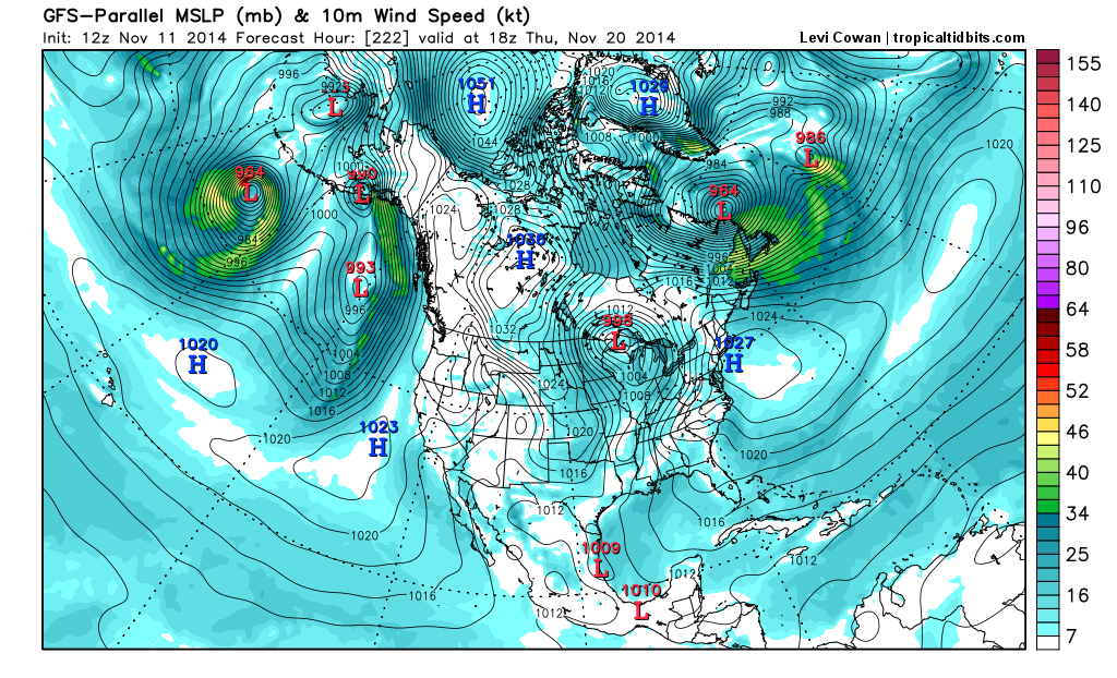
Obviously to far out to take seriously, but that is one impressive Arctic High near Alaska with a cross Polar flow well established into the longer range.
0 likes
Carla/Alicia/Jerry(In The Eye)/Michelle/Charley/Ivan/Dennis/Katrina/Rita/Wilma/Ike/Harvey
Member: National Weather Association
Wx Infinity Forums
http://wxinfinity.com/index.php
Facebook.com/WeatherInfinity
Twitter @WeatherInfinity
Member: National Weather Association
Wx Infinity Forums
http://wxinfinity.com/index.php
Facebook.com/WeatherInfinity
Twitter @WeatherInfinity
-
Ralph's Weather
- S2K Supporter
- Posts: 3371
- Age: 38
- Joined: Fri Dec 13, 2013 11:55 am
- Location: Lindale, TX
- Contact:
Re: Texas Fall-2014
Ntxw wrote:Ralph's Weather wrote:Every run for the past day plus has trended more and more this direction and it seems to match the pattern that we are in.
The shortwave is there, it was always there in various forms. Some model runs kick off a coastal low and throw back a lot of moisture and other times it doesn't and mostly dry. Either way there will be several pieces of energy to watch.
We are now around 100 hours out from this event so the models should start to get a better handle on it. The GFS Parallel seems to be pretty good at least in the 5 day type range.
0 likes
Follow on Facebook at Ralph's Weather.
-
TheProfessor

- Professional-Met

- Posts: 3506
- Age: 29
- Joined: Tue Dec 03, 2013 10:56 am
- Location: Wichita, Kansas

Re: Texas Fall-2014
srainhoutx wrote:Obviously to far out to take seriously, but that is one impressive Arctic High near Alaska with a cross Polar flow well established into the longer range.
http://i228.photobucket.com/albums/ee29 ... mer_38.png
The ENS have been showing displacement of a chunk of the Aleutian low and sinking it south across the southern US and perhaps up the Atlantic coast. Good chance a newsworthy Thanksgiving week system may take shape in that pattern. But we have more pressing matters currently, outside.
0 likes
The above post and any post by Ntxw is NOT an official forecast and should not be used as such. It is just the opinion of the poster and may or may not be backed by sound meteorological data. It is NOT endorsed by any professional institution including Storm2k. For official information, please refer to NWS products.
Help support Storm2K!
-
srainhoutx
- S2K Supporter
- Posts: 6919
- Age: 68
- Joined: Sun Jan 14, 2007 11:34 am
- Location: Haywood County, NC
- Contact:
Re: Texas Fall-2014
Ntxw wrote:srainhoutx wrote:Obviously to far out to take seriously, but that is one impressive Arctic High near Alaska with a cross Polar flow well established into the longer range.
http://i228.photobucket.com/albums/ee29 ... mer_38.png
The ENS have been showing displacement of a chunk of the Aleutian low and sinking it south across the southern US and perhaps up the Atlantic coast. Good chance a newsworthy Thanksgiving week system may take shape in that pattern. But we have more pressing matters currently, outside.
Yeah, there is some ensemble support for a Thanksgiving Holiday timeframe storm that has been showing up. As always, it's 15 days out so we will have to see if that trend continues.
0 likes
Carla/Alicia/Jerry(In The Eye)/Michelle/Charley/Ivan/Dennis/Katrina/Rita/Wilma/Ike/Harvey
Member: National Weather Association
Wx Infinity Forums
http://wxinfinity.com/index.php
Facebook.com/WeatherInfinity
Twitter @WeatherInfinity
Member: National Weather Association
Wx Infinity Forums
http://wxinfinity.com/index.php
Facebook.com/WeatherInfinity
Twitter @WeatherInfinity
-
TeamPlayersBlue

- Category 5

- Posts: 3530
- Joined: Tue Feb 02, 2010 1:44 am
- Location: Denver/Applewood, CO
Re: Texas Fall-2014
srainhoutx wrote:Obviously to far out to take seriously, but that is one impressive Arctic High near Alaska with a cross Polar flow well established into the longer range.
[img]http://i228.photobucket.com/albums/ee298/ srainhoutx/1111201412ZPGFS222gfsp_mslp_wind_namer_38.png[/img]
Yes.... Please... with the snow cover in place, we would be getting some really cold air down here.
Now as far as the snow map from the parallel GFS, i wasnt expecting any winter weather from this event so i dont want to get too excited. With the overrunning in place, all we need is the cold air though
0 likes
Personal Forecast Disclaimer:
The posts in this forum are NOT official forecast and should not be used as such. They are just the opinion of the poster and may or may not be backed by sound meteorological data. They are NOT endorsed by any professional institution or storm2k.org. For official information, please refer to the NHC and NWS products.
The posts in this forum are NOT official forecast and should not be used as such. They are just the opinion of the poster and may or may not be backed by sound meteorological data. They are NOT endorsed by any professional institution or storm2k.org. For official information, please refer to the NHC and NWS products.


-
Ralph's Weather
- S2K Supporter
- Posts: 3371
- Age: 38
- Joined: Fri Dec 13, 2013 11:55 am
- Location: Lindale, TX
- Contact:
Re: Texas Fall-2014
srainhoutx wrote:Ntxw wrote:srainhoutx wrote:Obviously to far out to take seriously, but that is one impressive Arctic High near Alaska with a cross Polar flow well established into the longer range.
http://i228.photobucket.com/albums/ee29 ... mer_38.png
The ENS have been showing displacement of a chunk of the Aleutian low and sinking it south across the southern US and perhaps up the Atlantic coast. Good chance a newsworthy Thanksgiving week system may take shape in that pattern. But we have more pressing matters currently, outside.
Yeah, there is some ensemble support for a Thanksgiving Holiday timeframe storm that has been showing up. As always, it's 15 days out so we will have to see if that trend continues.
There was some mention last week about a strong Aleutian low correlating to a US storm about 20 days later, that would seem to line up with a Thanksgiving week storm.
0 likes
Follow on Facebook at Ralph's Weather.


-
TeamPlayersBlue
- Category 5
- Posts: 3530
- Joined: Tue Feb 02, 2010 1:44 am
- Location: Denver/Applewood, CO
Ryan Maue post a bit ago. Posted the Euro 6 days out. I dont think we could draw a better map for an arctic front. Seriously. Its ridiculous.
RyanMaue: Day 6 (+144 hrs) ECMWF and GFS upgrade 12z models as close as you'll ever see in agreement on 500-mb height forecast http://t.co/6Znb0nFumx
RyanMaue: Day 6 (+144 hrs) ECMWF and GFS upgrade 12z models as close as you'll ever see in agreement on 500-mb height forecast http://t.co/6Znb0nFumx
0 likes
Personal Forecast Disclaimer:
The posts in this forum are NOT official forecast and should not be used as such. They are just the opinion of the poster and may or may not be backed by sound meteorological data. They are NOT endorsed by any professional institution or storm2k.org. For official information, please refer to the NHC and NWS products.
The posts in this forum are NOT official forecast and should not be used as such. They are just the opinion of the poster and may or may not be backed by sound meteorological data. They are NOT endorsed by any professional institution or storm2k.org. For official information, please refer to the NHC and NWS products.
-
BigB0882
- S2K Supporter
- Posts: 2292
- Joined: Thu Jul 03, 2003 12:08 am
- Location: Baton Rouge, LA
- Contact:
Re: Texas Fall-2014
I keep thinking "if only this were in January."
I also notice this cold blast resembles a lot of the early cold blasts last year that seemed to just scrape us over here in SELA while folks in SETX were getting more direct hits. Hopefully these cold blasts can make it far enough south and east to get us in on the action.
I also notice this cold blast resembles a lot of the early cold blasts last year that seemed to just scrape us over here in SELA while folks in SETX were getting more direct hits. Hopefully these cold blasts can make it far enough south and east to get us in on the action.
0 likes
Re: Texas Fall-2014
BigB0882 wrote:I keep thinking "if only this were in January."
I also notice this cold blast resembles a lot of the early cold blasts last year that seemed to just scrape us over here in SELA while folks in SETX were getting more direct hits. Hopefully these cold blasts can make it far enough south and east to get us in on the action.
Yeah, the driver for this outbreak is the same as last year (albeit with -AO, so it has staying power). The common denominator is the -EPO over NW NA and high pressure drives the cold. It's easier for cold to ooze due south underneath these highs with lowering slopes in the front range and great plains quickly than SE as they slow down and have more time to modify. Cold for the southeastern third to half requires more of a strong PV anomaly over the lakes and blocking centered more over Greenland.
0 likes
The above post and any post by Ntxw is NOT an official forecast and should not be used as such. It is just the opinion of the poster and may or may not be backed by sound meteorological data. It is NOT endorsed by any professional institution including Storm2k. For official information, please refer to NWS products.
Help support Storm2K!
Help support Storm2K!

I can confirm it is cold outside. 
0 likes
The above post and any post by dhweather is NOT an official forecast and should not be used as such. It is just the opinion of the poster and may or may not be backed by sound meteorological data. It is NOT endorsed by any professional institution including storm2k.org. For official information, please refer to NWS products.
-
Ralph's Weather
- S2K Supporter
- Posts: 3371
- Age: 38
- Joined: Fri Dec 13, 2013 11:55 am
- Location: Lindale, TX
- Contact:
The PGFS has continued to increase the snow accumulations for Sunday into Sunday night. Hopefully the other models will pick up on what it has been seeing for a number of runs. BTW it is showing very cold lows for Tuesday.

0 likes
Follow on Facebook at Ralph's Weather.
-
Portastorm

- Storm2k Moderator

- Posts: 9955
- Age: 63
- Joined: Fri Jul 11, 2003 9:16 am
- Location: Round Rock, TX
- Contact:
Re: Texas Fall-2014
Figures ... the southern extent of the line stops just north of Travis County.
0 likes
Any forecasts under my name are to be taken with a grain of salt. Get your best forecasts from the National Weather Service and National Hurricane Center.

Re: Texas Fall-2014
Portastorm wrote::uarrow:
Figures ... the southern extent of the line stops just north of Travis County.
You just aren't wishing hard enough, Porta! Throw science out the window and wait for your clock to hit 11:11!
0 likes
-
Portastorm
- Storm2k Moderator
- Posts: 9955
- Age: 63
- Joined: Fri Jul 11, 2003 9:16 am
- Location: Round Rock, TX
- Contact:
Re: Texas Fall-2014
iorange55 wrote:Portastorm wrote::uarrow:
Figures ... the southern extent of the line stops just north of Travis County.
You just aren't wishing hard enough, Porta! Throw science out the window and wait for your clock to hit 11:11!
Oh yeah, iorange55! That's right ... well, I guess we all better get our wishing in tonight and wish in those multiple Texas winter storms!
Wxman57 will no doubt be wishing the opposite.
0 likes
Any forecasts under my name are to be taken with a grain of salt. Get your best forecasts from the National Weather Service and National Hurricane Center.

Re: Texas Fall-2014
Portastorm wrote::uarrow:
Figures ... the southern extent of the line stops just north of Travis County.
It looks like it stops right at my house.
0 likes
Any opinions stated are those of an amateur, please take with several grains of salt and for official forecast refer to the National Weather Service.
-
aggiecutter
- Category 5
- Posts: 1755
- Joined: Thu Oct 14, 2004 9:22 pm
- Location: Texarkana
Re: Texas Fall-2014
Portastorm wrote::uarrow:
Figures ... the southern extent of the line stops just north of Travis County.
Ryan Maue @RyanMaue 4m4 minutes ago: nature has a sense of humor along w/GFS model, an #omegablock sets up shop over Austin next week.
0 likes
It isnt just the parallel, GFS at least has something flying in the air. Euro has been dry for a few runs after showing it for a few days. Lets see if it picks it back up within 100 hrs.
0 likes
The above post and any post by Ntxw is NOT an official forecast and should not be used as such. It is just the opinion of the poster and may or may not be backed by sound meteorological data. It is NOT endorsed by any professional institution including Storm2k. For official information, please refer to NWS products.
Help support Storm2K!
Help support Storm2K!
Return to “USA & Caribbean Weather”
Who is online
Users browsing this forum: No registered users and 54 guests