Texas Fall-2014

U.S. & Caribbean Weather Discussions and Severe Weather Events

Moderator: S2k Moderators

Forum rules

The posts in this forum are NOT official forecast and should not be used as such. They are just the opinion of the poster and may or may not be backed by sound meteorological data. They are NOT endorsed by any professional institution or STORM2K.

Help Support Storm2K
Message
Author
GRAYSONCO.WX
Category 1
Category 1
Posts: 450
Joined: Thu Jan 06, 2011 4:29 pm
Location: Denison, Texas

Re: Re:

#1301 Postby GRAYSONCO.WX » Fri Nov 14, 2014 5:22 pm

SouthernMet wrote:
Ralph's Weather wrote:18Z PGFS is pretty weak with the Sunday system. I hope there is more to this system than just some flurries, that would be a big waste of all of this cold air. And the 18Z GFS goes north into OK with it.


As far as the pgfs... atleast it has snow accumulation at all, as opposed to the 12z.. Its a good trend.


Indeed!
0 likes   

Ralph's Weather
S2K Supporter
S2K Supporter
Posts: 3269
Age: 37
Joined: Fri Dec 13, 2013 11:55 am
Location: Lindale, TX
Contact:

Re: Re:

#1302 Postby Ralph's Weather » Fri Nov 14, 2014 5:52 pm

SouthernMet wrote:
Ralph's Weather wrote:18Z PGFS is pretty weak with the Sunday system. I hope there is more to this system than just some flurries, that would be a big waste of all of this cold air. And the 18Z GFS goes north into OK with it.


As far as the pgfs... atleast it has snow accumulation at all, as opposed to the 12z.. Its a good trend.

Agreed, just going that this is not what we settle on. The storm is just reaching the Northwest so maybe there will be some surprises as it is sampled more.
0 likes   
Follow on Facebook at Ralph's Weather.

User avatar
SouthernMet
Category 3
Category 3
Posts: 857
Joined: Sun Aug 29, 2010 8:23 pm
Location: fort worth, tx

Re: Texas Fall-2014

#1303 Postby SouthernMet » Fri Nov 14, 2014 5:56 pm

Is it too early to get your thoughts Orangeblood? :wink:
0 likes   
Nothing that SouthernMet posts, is an official forecast,nor does it reflect views of STORM2K.. SouthernMet is just adding to the great discussions on STORM2K.. Refer to NWS for official forecasts.

User avatar
JDawg512
Category 5
Category 5
Posts: 1074
Age: 45
Joined: Mon Aug 26, 2013 8:56 pm
Location: Austin
Contact:

Re: Texas Fall-2014

#1304 Postby JDawg512 » Fri Nov 14, 2014 9:17 pm

My weather station recorded 27 degrees early this morning here on the southside a couple of blocks from South Austin Hospital. Even though I covered my tomatos and peppers, it didn't any good at saving them.
0 likes   
Resident Rain Miser

I am a weather hobbyist living 3.5 miles south of Downtown Austin and in no way or fashion should anything I say concerning forecasts be taken seriously. Please check your local NWS for accurate weather forecasting and conditions.

User avatar
Ntxw
Storm2k Moderator
Storm2k Moderator
Posts: 22731
Joined: Wed Oct 21, 2009 6:34 pm
Location: DFW, Texas

#1305 Postby Ntxw » Fri Nov 14, 2014 10:39 pm

From FW this afternoon


.CLIMATE...
DFW AIRPORT HAS STAYED AT OR BELOW 40 DEGREES FOR 3 CONSECUTIVE
DAYS. THIS HAS HAPPENED ONLY ONCE BEFORE DURING NOVEMBER...IN
1976.
0 likes   
The above post and any post by Ntxw is NOT an official forecast and should not be used as such. It is just the opinion of the poster and may or may not be backed by sound meteorological data. It is NOT endorsed by any professional institution including Storm2k. For official information, please refer to NWS products.

  Help support Storm2K!
Help Support Storm2K

orangeblood
S2K Supporter
S2K Supporter
Posts: 3714
Joined: Tue Dec 15, 2009 6:14 pm
Location: Fort Worth, TX

Re:

#1306 Postby orangeblood » Fri Nov 14, 2014 11:33 pm

Ntxw wrote:From FW this afternoon


.CLIMATE...
DFW AIRPORT HAS STAYED AT OR BELOW 40 DEGREES FOR 3 CONSECUTIVE
DAYS. THIS HAS HAPPENED ONLY ONCE BEFORE DURING NOVEMBER...IN
1976.


Should not be surprising to those that follow the analogs for this winter but still an incredible feat for this time of year. RE; Sunday's system, unfortunately it appears most of the UL energy will stay to our north across Oklahoma this time around...lifting mechanism isn't quite there. Hopefully we can squeeze out a few light snow flakes though.
0 likes   

gpsnowman
S2K Supporter
S2K Supporter
Posts: 3157
Joined: Fri Jan 07, 2011 10:35 am
Location: Grand Prairie Tx

#1307 Postby gpsnowman » Sat Nov 15, 2014 9:05 am

The snow line is getting pushed more to the southeast according to the NWS morning map.

http://www.srh.noaa.gov/images/fxc/fwd/ ... image1.gif
0 likes   

User avatar
KatDaddy
Category 5
Category 5
Posts: 2815
Joined: Mon Oct 21, 2002 6:23 pm
Location: League City, Texas

#1308 Postby KatDaddy » Sat Nov 15, 2014 9:18 am

SE TX temps to rise into the upper 50s inland to low 60s along the coastal areas. Increasing rain and thunderstorm chances this afternoon as a low pressure area moves up the TX Coast. S of the warm front areas will have a marginal risk of severe storms tonight. Currently this looks to be areas S and E of Highway 59. In addition these areas may pick up 1-3" of rain by Sunday night before a strong cold front pushes offshore. NTX snowfall is looking more likely this morning beginning late tomorrow afternoon and overnight. The models are showing the strong cold front arriving earlier than previous runs. Accumulating snow may be possible on grassy and elevated surfaces to the N and W of the DFW Metroplex.
0 likes   
The following post is NOT an official forecast and should not be used as such. It is just the opinion of the poster and may or may not be backed by sound meteorological data. It is NOT endorsed by any professional institution including storm2k.org For Official Information please refer to the NHC and NWS products.

gpsnowman
S2K Supporter
S2K Supporter
Posts: 3157
Joined: Fri Jan 07, 2011 10:35 am
Location: Grand Prairie Tx

#1309 Postby gpsnowman » Sat Nov 15, 2014 9:23 am

Thanks KatDaddy, another arctic front busting the models again it seems. Temps all this week in DFW have been much lower than forecasted. Maybe the same can be said for this one as well. Just need some more moisture to work with. You know it is winter when we start seeing NAM updates!! Hope to see some snow tomorrow.
0 likes   

User avatar
srainhoutx
S2K Supporter
S2K Supporter
Posts: 6919
Age: 67
Joined: Sun Jan 14, 2007 11:34 am
Location: Haywood County, NC
Contact:

Re: Texas Fall-2014

#1310 Postby srainhoutx » Sat Nov 15, 2014 9:30 am

Morning briefing from Jeff:

Cold arctic air mass remains in place over the region this morning with another colder surge heading for the US border out of Canada.

Coastal trough and surface low pressure system starting to take shape along the lower TX coast will bring an active 36 hours to the region.

Temperatures this morning running a solid 10 degrees above Friday morning values. Freeze line Friday morning ran roughly along US 59 north of Houston to FM 2920 to Waller then WSW to Columbus. Mid level cloud deck hampered central and coastal counties freezing conditions Friday morning…but we will all have another shot next week. Surface arctic dome is attempting to modify, but increasing ENE to NE winds will help lock in the cold air today. Clouds have never really cleared out much since last Tuesday and will only increase with thickening and lowering today as moisture is pulled northward over the surface cold pool. Think surface dry layer will take much of today to saturate before rainfall becomes a concern…likely not until this evening. Patchy fog and some drizzle may develop by mid to late afternoon as the surface warm front moves toward the coast.

Strong short wave will help to energize the coastal low tonight and bring it near/just inland over the upper TX coast. Warm front progresses toward the coast and possibly inland as far as US 59 overnight into Sunday with significantly warmer temperatures (60’s) south of that boundary, in fact there may be a fairly impressive temperature gradient across the area early Sunday. Low level shear values are maximized late tonight into early Sunday along and south of US 59 and if any of the elevated storms can work toward the surface and take advantage of the strong low level shear an isolated severe storm will be possible. Main threats will be wind damage and isolated tornadoes.

Widespread rain will blanket much of the area from late tonight through most of Sunday with heavy rainfall certainly possible. Rainfall amounts have been increased in the past 24 hours and now suggest an average of 1-3 inches is possible across the region with the heaviest rain likely near and south of the warm frontal boundary.

Secondary arctic surge with temperatures over NW Canada currently well below zero will roar southward behind this storm system and off the TX coast late Sunday. Very strong cold air advection will result in tumbling temperatures by Sunday evening likely from the 50’s and 60’s into the 30’s and 40’s with strong winds. Gale Watch is in effect for the Gulf waters and a Gale Warning will likely be needed as very strong NW winds develop under the building arctic high and models showing 925mb winds of 40-45kts Sunday night over the coastal bend into the Gulf waters. A third weaker short wave will move across mainly the northern part of the state Sunday afternoon into Sunday night. Models are a little more aggressive with the onset and intensity of the cold air advection which brings P-type into question for Sunday afternoon and evening mainly across north TX. Expect a rain/snow line to develop and move southward Sunday afternoon as the air column cools. A mixture of might rain/flurries may extend as far south as the Hill Country Sunday evening. Current thinking is that the profiles over SE TX will still be too warm for any P-type mixture Sunday night as the rain ends.

If clouds can clear out Monday then a widespread freeze is likely by Tuesday morning with lows in the upper 20’s and lower 30’s. As we saw yesterday however cloud cover will play havoc with the overnight lows.

A sustained warming tend looks likely by the end of next week with southerly flow returning along with clouds and rain chances. In fact temperatures may warm into the lower 70’s by next Friday as this arctic outbreak is dislodged.
0 likes   
Carla/Alicia/Jerry(In The Eye)/Michelle/Charley/Ivan/Dennis/Katrina/Rita/Wilma/Ike/Harvey

Member: National Weather Association
Wx Infinity Forums
http://wxinfinity.com/index.php

Facebook.com/WeatherInfinity
Twitter @WeatherInfinity

User avatar
SouthernMet
Category 3
Category 3
Posts: 857
Joined: Sun Aug 29, 2010 8:23 pm
Location: fort worth, tx

Re: Texas Fall-2014

#1311 Postby SouthernMet » Sat Nov 15, 2014 9:54 am

2 interesting things... PGFS wants to dissipate the precip before it reaches dfw, NAM/CMC kinda the same but CMC gives the northern 2 rows some decent action (Denton/Gainesville/Denision). NAM just west/nw of metro before it completely dissipates..

But.... fwiw the UKMET actually holds the band together through dfw, with decent qpf, which is very intresting.

New 12z NAM has moderate band from Lubbock-Childress in 36 hours, with light precip all across west central tx, but by 42 hours it's all gone..
0 likes   
Nothing that SouthernMet posts, is an official forecast,nor does it reflect views of STORM2K.. SouthernMet is just adding to the great discussions on STORM2K.. Refer to NWS for official forecasts.

GRAYSONCO.WX
Category 1
Category 1
Posts: 450
Joined: Thu Jan 06, 2011 4:29 pm
Location: Denison, Texas

Re: Texas Fall-2014

#1312 Postby GRAYSONCO.WX » Sat Nov 15, 2014 10:14 am

SouthernMet wrote:2 interesting things... PGFS wants to dissipate the precip before it reaches dfw, NAM/CMC kinda the same but CMC gives the northern 2 rows some decent action (Denton/Gainesville/Denision). NAM just west/nw of metro before it completely dissipates..

But.... fwiw the UKMET actually holds the band together through dfw, with decent qpf, which is very intresting.

New 12z NAM has moderate band from Lubbock-Childress in 36 hours, with light precip all across west central tx, but by 42 hours it's all gone..

I see that. It's so odd that that band of precipitation just dissipates so quickly.
0 likes   

weatherdude1108
Category 5
Category 5
Posts: 4228
Joined: Tue Dec 13, 2011 1:04 pm
Location: Northwest Austin/Cedar Park, TX

#1313 Postby weatherdude1108 » Sat Nov 15, 2014 10:47 am

Meanwhile, Lakes Travis and Buchanan rose 2 to 2.5 INCHES during this last widespread rain event. :roll:

A large weather system brought gentle rain to the entire lower Colorado River basin in early November, but the rainfall provided very little runoff to the Highland Lakes. Most of the rainfall soaked into extremely dry soil. In all, the rain added about 3,800 acre-feet to storage in lakes Buchanan and Travis. Lake Buchanan rose about 2 inches, and Lake Travis rose about 2 ½ inches.

http://www.lcra.org/water/water-supply/ ... fault.aspx
0 likes   
The preceding post is NOT an official forecast, and should not be used as such. It is only the opinion of the poster and may or may not be backed by sound meteorological data. It is NOT endorsed by any professional institution including storm2k.org. For Official Information please refer to the NHC and NWS products.

User avatar
srainhoutx
S2K Supporter
S2K Supporter
Posts: 6919
Age: 67
Joined: Sun Jan 14, 2007 11:34 am
Location: Haywood County, NC
Contact:

Re: Texas Fall-2014

#1314 Postby srainhoutx » Sat Nov 15, 2014 10:58 am

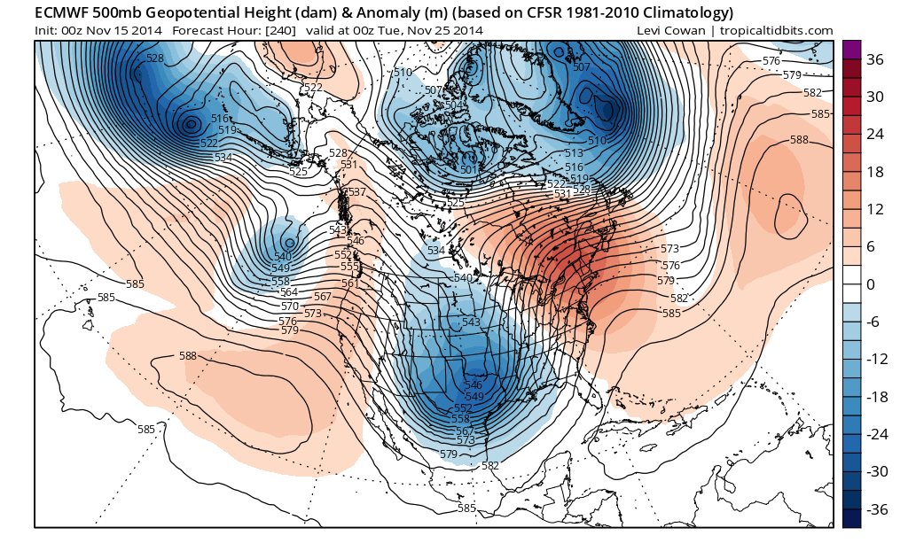
The Edwards Aquifer rose 8 ft earlier in the month and with El Nino showing its hand already, I suspect we will see improvements during the Winter and Spring with an active storm track across the Desert SW, Northern Mexico and Texas. The longer range guidance is looking favorable for increasing rainfall as we end November for the Highland Lakes of Central Texas.

Image
0 likes   
Carla/Alicia/Jerry(In The Eye)/Michelle/Charley/Ivan/Dennis/Katrina/Rita/Wilma/Ike/Harvey

Member: National Weather Association
Wx Infinity Forums
http://wxinfinity.com/index.php

Facebook.com/WeatherInfinity
Twitter @WeatherInfinity

User avatar
wxman57
Moderator-Pro Met
Moderator-Pro Met
Posts: 22951
Age: 67
Joined: Sat Jun 21, 2003 8:06 pm
Location: Houston, TX (southwest)

Re: Texas Fall-2014

#1315 Postby wxman57 » Sat Nov 15, 2014 11:24 am

12Z PGFS keeps the snow confined to the TX panhandle tomorrow night/early Monday. There doesn't appear to be enough moisture for any snow in the DFW area.
0 likes   

aggiecutter
Category 5
Category 5
Posts: 1751
Joined: Thu Oct 14, 2004 9:22 pm
Location: Texarkana

Re: Texas Fall-2014

#1316 Postby aggiecutter » Sat Nov 15, 2014 11:27 am

Chance of rain and snow for Texarkana tomorrow night:

Sunday Night A chance of rain and snow. Mostly cloudy, with a low around 29. Northwest wind around 10 mph. Chance of precipitation is 50%.
Monday Sunny, with a high near 44. Northwest wind 10 to 15 mph increasing to 15 to 20 mph in the afternoon. Winds could gust as high as 30 mph.
Monday Night Mostly clear, with a low around 23.
0 likes   

User avatar
Ntxw
Storm2k Moderator
Storm2k Moderator
Posts: 22731
Joined: Wed Oct 21, 2009 6:34 pm
Location: DFW, Texas

Re: Texas Fall-2014

#1317 Postby Ntxw » Sat Nov 15, 2014 11:33 am

srainhoutx wrote:The Edwards Aquifer rose 8 ft earlier in the month and with El Nino showing its hand already, I suspect we will see improvements during the Winter and Spring with an active storm track across the Desert SW, Northern Mexico and Texas. The longer range guidance is looking favorable for increasing rainfall as we end November for the Highland Lakes of Central Texas.

http://i228.photobucket.com/albums/ee29 ... mer_11.png


Those are very low heights. Looks like the OP is finally picking up on the Thanksgiving week storm potential as been showing for days on the ensembles. Disruptive for travelers busiest travel week.
0 likes   
The above post and any post by Ntxw is NOT an official forecast and should not be used as such. It is just the opinion of the poster and may or may not be backed by sound meteorological data. It is NOT endorsed by any professional institution including Storm2k. For official information, please refer to NWS products.


  Help support Storm2K!

Help Support Storm2K


GRAYSONCO.WX
Category 1
Category 1
Posts: 450
Joined: Thu Jan 06, 2011 4:29 pm
Location: Denison, Texas

Re: Texas Fall-2014

#1318 Postby GRAYSONCO.WX » Sat Nov 15, 2014 11:39 am

wxman57 wrote:12Z PGFS keeps the snow confined to the TX panhandle tomorrow night/early Monday. There doesn't appear to be enough moisture for any snow in the DFW area.

The haters gonna hate, hate, hate, hate, hate! :D
0 likes   

User avatar
Ntxw
Storm2k Moderator
Storm2k Moderator
Posts: 22731
Joined: Wed Oct 21, 2009 6:34 pm
Location: DFW, Texas

#1319 Postby Ntxw » Sat Nov 15, 2014 11:41 am

Pfft cherry pick the Ukmet! Some windshield flakes counts as a win
0 likes   
The above post and any post by Ntxw is NOT an official forecast and should not be used as such. It is just the opinion of the poster and may or may not be backed by sound meteorological data. It is NOT endorsed by any professional institution including Storm2k. For official information, please refer to NWS products.


  Help support Storm2K!

Help Support Storm2K


User avatar
Tireman4
S2K Supporter
S2K Supporter
Posts: 5851
Age: 59
Joined: Fri Jun 30, 2006 1:08 pm
Location: Humble, Texas
Contact:

Re:

#1320 Postby Tireman4 » Sat Nov 15, 2014 12:03 pm

Ntxw wrote:Pfft cherry pick the Ukmet! Some windshield flakes counts as a win


That is it Ntwx...I like it too. Just a little on the windshield and that will send Wxman 57 scurrying...:)
0 likes   


Return to “USA & Caribbean Weather”

Who is online

Users browsing this forum: Cpv17 and 39 guests