Texas Winter 2014-2015

Winter Weather Discussion

Moderator: S2k Moderators

Forum rules

The posts in this forum are NOT official forecast and should not be used as such. They are just the opinion of the poster and may or may not be backed by sound meteorological data. They are NOT endorsed by any professional institution or STORM2K.

Help Support Storm2K
Message
Author
User avatar
Ntxw
Storm2k Moderator
Storm2k Moderator
Posts: 22784
Joined: Wed Oct 21, 2009 6:34 pm
Location: DFW, Texas

#261 Postby Ntxw » Sat Nov 29, 2014 11:06 pm

More present matters, Arctic front making its way through Sunday night/Monday morning. DFW will be dropping to mid 30s by late afternoon and the wind chill be even nastier. It may not feel it in the morning, but bring a hefty jacket. This cold air mass is bullying it's way down under it's own weight.

Image

Believe it or not, there is more cold in Canada now than there was this week last year during the big outbreak. Last year though had optimum 500mb flow to deliver and not so this week, but just a reminder of how cold it really is up there of late.

2013
Image
0 likes   
The above post and any post by Ntxw is NOT an official forecast and should not be used as such. It is just the opinion of the poster and may or may not be backed by sound meteorological data. It is NOT endorsed by any professional institution including Storm2k. For official information, please refer to NWS products.

  Help support Storm2K!
Help Support Storm2K

User avatar
srainhoutx
S2K Supporter
S2K Supporter
Posts: 6919
Age: 67
Joined: Sun Jan 14, 2007 11:34 am
Location: Haywood County, NC
Contact:

Re: Texas Winter 2014-2015

#262 Postby srainhoutx » Sun Nov 30, 2014 8:22 am

Folks across N Texas mainly north of the Metroplex need to keep on eye out for some light freezing drizzle Monday afternoon into early Tuesday. Travel issues do not look like a big concern, but light icing on metal surfaces and trees may be possible. Ground temperatures are just too warm for any elevated bridge issues as of right now. Light icing may spread further E toward Texarkana early Tuesday as the sharp/shallow very cold airmass allows over running moisture to develop with the up glide. Stay warm. This quick hitting shot of cold air will feel much different than the upper 70's to low 80's we've been experiencing.

Image
0 likes   
Carla/Alicia/Jerry(In The Eye)/Michelle/Charley/Ivan/Dennis/Katrina/Rita/Wilma/Ike/Harvey

Member: National Weather Association
Wx Infinity Forums
http://wxinfinity.com/index.php

Facebook.com/WeatherInfinity
Twitter @WeatherInfinity

User avatar
wxman57
Moderator-Pro Met
Moderator-Pro Met
Posts: 22978
Age: 67
Joined: Sat Jun 21, 2003 8:06 pm
Location: Houston, TX (southwest)

Re: Texas Winter 2014-2015

#263 Postby wxman57 » Sun Nov 30, 2014 9:20 am

High in Houston should be near 80 today. After winning the office first freeze contest I have successfully turned off winter for 2014-2015. There's no sign of anything remotely close to what we saw the 3rd week of November over the next couple of weeks.
0 likes   

User avatar
srainhoutx
S2K Supporter
S2K Supporter
Posts: 6919
Age: 67
Joined: Sun Jan 14, 2007 11:34 am
Location: Haywood County, NC
Contact:

Re: Texas Winter 2014-2015

#264 Postby srainhoutx » Sun Nov 30, 2014 9:40 am

The global guidance continues to advertise a changeable pattern in the medium to longer range as we head deeper into December. After our quick cool down Monday night into Tuesday, foggy continues look to be the theme as the sharp Arctic front retreats N rather quickly in the zonal flow off the Pacific. There are indications that another storm system may develop in the Southern jet stream later this week into next weekend as the southern branch system has more energy associated with it than the northern branch due to the fast zonal flow and the coldest air remains bottled up N of the US border.

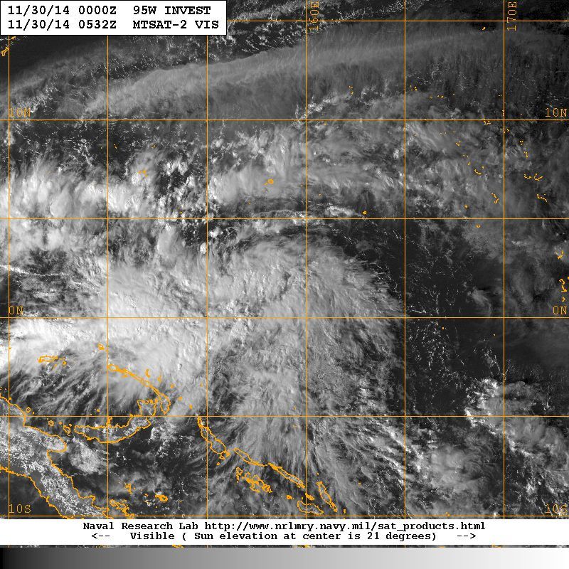
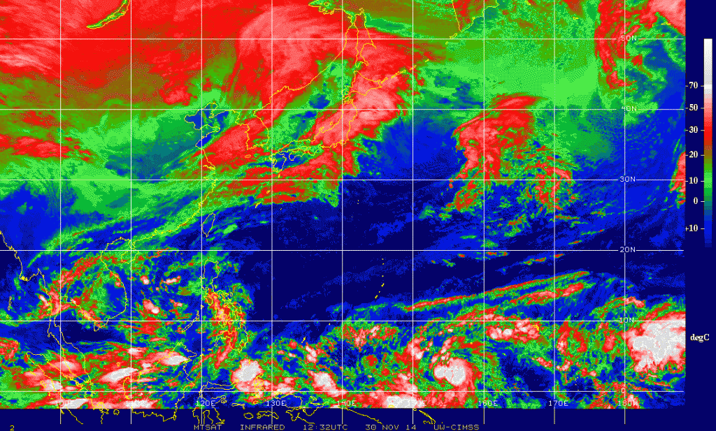
The fly in the ointment in the longer range will be what becomes of a developing tropical cyclone in the Western Pacific (95W) near New Guinea. It is important to understand that what happens halfway around the world does have an effect on our sensible weather across North America. The Global models are suggesting a powerful Typhoon will develop and skirt near the Philippines and eventual recurve into a powerful cold upper low near the Aleutian Islands and Bering Sea in about 10-12 days. Such a pattern developed with Super Typhoon Nuri as you recall back in early November that reshuffled the entire planetary weather pattern across the Northern Hemisphere and brought our record breaking cold outbreak mid-November. It is also noteworthy that the global models are suggesting the cold pool of water across the Northern Pacific (PDO) will continue to be strongly positive. We have not witnessed a strongly +PDO for many years, so that suggests the colder stormier weather is very possible along and E of the Continental Divide. Other teleconnection indices we monitor are trending toward a pattern that is very capable of delivery cold air very far south. In fact, if the –EPO (East Pacific Oscillation), + PNA (Pacific-North American Pattern) and a – AO (Arctic Oscillation) coincide with a –NAO (North Atlantic Oscillation), then it is very possible the coldest air of the Winter Season may arrive before Christmas. It is also noteworthy that the sub-tropical jet appears to remain very noisy allowing for mid/upper level tropical moisture to stream over any cold airmass at the surface that may be in place later in the month. Typically we need to monitor for areas of low pressure in the upper levels that track across Northern Mexico into the Southern Rockies and the Southern Plains. It is always a wildcard to forecast any surface lows spinning up along the NW Gulf Coast, but usually we see such a pattern in Winter where coastal waves of low pressure develop and sometimes deepen into rather strong Coastal Lows as they move N and E toward the Atlantic. In closing the pattern looks rather volatile, so expect changes as we enter the month of December and deeper into Winter during January.

Image

Image
Last edited by srainhoutx on Sun Nov 30, 2014 9:41 am, edited 1 time in total.
0 likes   
Carla/Alicia/Jerry(In The Eye)/Michelle/Charley/Ivan/Dennis/Katrina/Rita/Wilma/Ike/Harvey

Member: National Weather Association
Wx Infinity Forums
http://wxinfinity.com/index.php

Facebook.com/WeatherInfinity
Twitter @WeatherInfinity

User avatar
Tireman4
S2K Supporter
S2K Supporter
Posts: 5853
Age: 59
Joined: Fri Jun 30, 2006 1:08 pm
Location: Humble, Texas
Contact:

Re: Texas Winter 2014-2015

#265 Postby Tireman4 » Sun Nov 30, 2014 9:40 am

wxman57 wrote:High in Houston should be near 80 today. After winning the office first freeze contest I have successfully turned off winter for 2014-2015. There's no sign of anything remotely close to what we saw the 3rd week of November over the next couple of weeks.


Winter has not even begun young sir. Keep your tires inflated for Winter will come sir. It will come with a vengeance. It shall and must. :)
0 likes   

User avatar
cycloneye
Admin
Admin
Posts: 145303
Age: 68
Joined: Thu Oct 10, 2002 10:54 am
Location: San Juan, Puerto Rico

Re: Texas Winter 2014-2015

#266 Postby cycloneye » Sun Nov 30, 2014 12:27 pm

What is now 95W ends up in the Alaska area 2 weeks from now as a powerful extratropical low.

Image
0 likes   
Visit the Caribbean-Central America Weather Thread where you can find at first post web cams,radars
and observations from Caribbean basin members Click Here

User avatar
gatorcane
S2K Supporter
S2K Supporter
Posts: 23691
Age: 47
Joined: Sun Mar 13, 2005 3:54 pm
Location: Boca Raton, FL

#267 Postby gatorcane » Sun Nov 30, 2014 12:46 pm

Long-range GEM shows some cold anomalies for Texas. Parallel GFS does too though not as cold. Interesting that both models show near identical anomalies as far as where the cold and warm anomalies will setup even by day 10 for the U.S. and southern Canada:

Image

Image
0 likes   

User avatar
Ntxw
Storm2k Moderator
Storm2k Moderator
Posts: 22784
Joined: Wed Oct 21, 2009 6:34 pm
Location: DFW, Texas

Re:

#268 Postby Ntxw » Sun Nov 30, 2014 1:14 pm

gatorcane wrote:Long-range GEM shows some cold anomalies for Texas. Parallel GFS does too though not as cold. Interesting that both models show near identical anomalies as far as where the cold and warm anomalies will setup even by day 10 for the U.S. and southern Canada:

http://i60.tinypic.com/3029kcz.jpg

http://i59.tinypic.com/2uo6zcl.jpg


Thanks for posting this! It really points out well the typical El Nino climo of how it is warm north, cool south. The Subtropical jet is the culprit.
0 likes   
The above post and any post by Ntxw is NOT an official forecast and should not be used as such. It is just the opinion of the poster and may or may not be backed by sound meteorological data. It is NOT endorsed by any professional institution including Storm2k. For official information, please refer to NWS products.


  Help support Storm2K!

Help Support Storm2K


User avatar
TheProfessor
Professional-Met
Professional-Met
Posts: 3506
Age: 28
Joined: Tue Dec 03, 2013 10:56 am
Location: Wichita, Kansas

#269 Postby TheProfessor » Sun Nov 30, 2014 5:34 pm

Can small ponds change air temperature? I was walking my dog earlier last week and as I came within 100-200 yards of the pond The air temperature became about 5-10 degrees colder, and then When I walked away from the pond the air warmed back up.
0 likes   
An alumnus of The Ohio State University.

Your local National Weather Service office is your best source for weather information.

Nairobi

#270 Postby Nairobi » Sun Nov 30, 2014 6:33 pm

Still no freezing surface temperatures for Dallas or Austin predicted by the ECMWF thru December 10. Nor by GFS thru December 16.
0 likes   

Nairobi

Re: Texas Winter 2014-2015

#271 Postby Nairobi » Sun Nov 30, 2014 6:38 pm

cycloneye wrote:What is now 95W ends up in the Alaska area 2 weeks from now as a powerful extratropical low.


Not according to ECMWF.
0 likes   

User avatar
Ntxw
Storm2k Moderator
Storm2k Moderator
Posts: 22784
Joined: Wed Oct 21, 2009 6:34 pm
Location: DFW, Texas

Re:

#272 Postby Ntxw » Sun Nov 30, 2014 6:49 pm

Nairobi wrote:Still no freezing surface temperatures for Dallas or Austin predicted by the ECMWF thru December 10. Nor by GFS thru December 16.


It'l be 35 in the middle of the afternoon tomorrow in Dallas. Close enough, brrr.
0 likes   
The above post and any post by Ntxw is NOT an official forecast and should not be used as such. It is just the opinion of the poster and may or may not be backed by sound meteorological data. It is NOT endorsed by any professional institution including Storm2k. For official information, please refer to NWS products.


  Help support Storm2K!

Help Support Storm2K


User avatar
cycloneye
Admin
Admin
Posts: 145303
Age: 68
Joined: Thu Oct 10, 2002 10:54 am
Location: San Juan, Puerto Rico

Re: Texas Winter 2014-2015

#273 Postby cycloneye » Sun Nov 30, 2014 8:12 pm

Nairobi wrote:
cycloneye wrote:What is now 95W ends up in the Alaska area 2 weeks from now as a powerful extratropical low.


Not according to ECMWF.


95W is now TD 22W at the first warning issued. The warning has the track recurving as a powerful Typhoon as they go with the GFS recurving scenario. Go to the TD 22W thread to see the details.
0 likes   
Visit the Caribbean-Central America Weather Thread where you can find at first post web cams,radars
and observations from Caribbean basin members Click Here

User avatar
gatorcane
S2K Supporter
S2K Supporter
Posts: 23691
Age: 47
Joined: Sun Mar 13, 2005 3:54 pm
Location: Boca Raton, FL

#274 Postby gatorcane » Sun Nov 30, 2014 8:26 pm

The cold air continues to build over Canada with a -38F showing up this hour. Question now is can 95L in the WPAC eventually cause a pattern shift across North America to funnel this very cold air south down the road?

Image
0 likes   

Nairobi

#275 Postby Nairobi » Sun Nov 30, 2014 8:56 pm

Probably not per the ECMWF. Its ensembles have a very weak system heading across the central Philippines on a westward track to southern Vietnam. The operational is much stronger but on an almost identical track.
Last edited by Nairobi on Sun Nov 30, 2014 9:03 pm, edited 1 time in total.
0 likes   

User avatar
Texas Snowman
Storm2k Moderator
Storm2k Moderator
Posts: 6179
Joined: Fri Jan 25, 2008 11:29 am
Location: Denison, Texas

#276 Postby Texas Snowman » Sun Nov 30, 2014 9:03 pm

Meanwhile, it's 30 in Amarillo and 35 in Oklahoma City. Currently 70 in Denison prior to the frontal passage.

Temps in the 30s all day tomorrow here in the Red River Valley. NWS is forecasting a low of 33 overnight, a high of 36 tomorrow and a low of 32 tomorrow night.

Nice first day of December coming up!
0 likes   
The above post and any post by Texas Snowman is NOT an official forecast and should not be used as such. It is just the opinion of the poster and may or may not be backed by sound meteorological data. It is NOT endorsed by any professional institution including storm2k.org. For official information, please refer to NWS products.

User avatar
Ntxw
Storm2k Moderator
Storm2k Moderator
Posts: 22784
Joined: Wed Oct 21, 2009 6:34 pm
Location: DFW, Texas

#277 Postby Ntxw » Sun Nov 30, 2014 9:54 pm

Arctic front is still racing southward. At this rate it may cross well before 3 am.
0 likes   
The above post and any post by Ntxw is NOT an official forecast and should not be used as such. It is just the opinion of the poster and may or may not be backed by sound meteorological data. It is NOT endorsed by any professional institution including Storm2k. For official information, please refer to NWS products.


  Help support Storm2K!

Help Support Storm2K


Ralph's Weather
S2K Supporter
S2K Supporter
Posts: 3269
Age: 38
Joined: Fri Dec 13, 2013 11:55 am
Location: Lindale, TX
Contact:

#278 Postby Ralph's Weather » Mon Dec 01, 2014 5:29 am

I am currently sitting at 63 with the front about to cross over me. Looks like it will be a drizzly, cold day. Northwestern North Texas could see some freezing drizzle so we will have to keep an eye on the freeze line.
0 likes   
Follow on Facebook at Ralph's Weather.

gpsnowman
S2K Supporter
S2K Supporter
Posts: 3185
Joined: Fri Jan 07, 2011 10:35 am
Location: Grand Prairie Tx

#279 Postby gpsnowman » Mon Dec 01, 2014 5:51 am

Happy December everyone. An exciting three months are ahead and I am looking forward to sharing winter weather thoughts with everyone.
Very windy drivng to work this morning. Car temp read 42. I expect the temp to drop all day. More typical of December. Yesterday was way too warm for my taste. This is more like it.
0 likes   

User avatar
srainhoutx
S2K Supporter
S2K Supporter
Posts: 6919
Age: 67
Joined: Sun Jan 14, 2007 11:34 am
Location: Haywood County, NC
Contact:

Re: Texas Winter 2014-2015

#280 Postby srainhoutx » Mon Dec 01, 2014 8:40 am

Morning briefing from Jeff:

Big changes on the way today as a strong cold front moves across the area.

Arctic boundary located along a line from Del Rio to Georgetown at 700am. Temperatures across this boundary show at least a 20 degree drop in an hour or so. College Station is currently 63 and Waco 41 (wind chill of 32). Cold front will advance across SE TX today with rapidly falling temperatures and increasing north winds. Radar shows showers along the coast this morning attempting to spread inland and HRRR short term model shows some additional development especially along US 59 and toward the coast late this morning/afternoon as the shallow arctic boundary moves through. Cold front should reach College Station between 800-900am and metro Houston 1100-noon and then off the coast in the 300-400pm period.

Fairly messy week on tap as arctic front stalls in the nearshore waters late tonight and upglide of warm air over the surface cold dome establishes. This will result in a period of cold and damp conditions on Tuesday with light drizzle, fog, and thick cloud cover preventing much if any temperature recovery. Expect temperatures to remain nearly steady in the 40’s to low 50’s on Tuesday.

Forecast becomes more uncertain on Wednesday with the main question being when does the arctic boundary lift northward as a warm front with warm and muggy conditions returning. I will trend toward the slower northward progression of the boundary with thick cloud cover north of the front helping to mitigate the warming. Upglide will continue and expect light drizzle and foggy conditions into Wednesday. Temperatures will start to slowly rise on Tuesday evening and continue on Wednesday with highs likely back into the 70’s by Thursday.

Warm front should return northward late Wednesday into Thursday with dewpoints recovering into the 60’s. Abundant mid and high level moisture will stream into the region from the Pacific while low level moisture increases at the surface yielding a cloudy and at times wet forecast Thursday-next weekend. Hard to time short waves in the SW flow aloft will determine when the best rain chances will be indicated. Temperatures will return to above normal values for early December as southerly low level flow is established. Will need to keep an eye on potential for near shore/ bays sea fog by Friday as dewpoints rise above the “chilled” waters near the coast.


0 likes   
Carla/Alicia/Jerry(In The Eye)/Michelle/Charley/Ivan/Dennis/Katrina/Rita/Wilma/Ike/Harvey

Member: National Weather Association
Wx Infinity Forums
http://wxinfinity.com/index.php

Facebook.com/WeatherInfinity
Twitter @WeatherInfinity


Return to “Winter Weather”

Who is online

Users browsing this forum: No registered users and 8 guests