WPAC: HAGUPIT - Post-Tropical
Moderator: S2k Moderators

-
euro6208
Re: WPAC: HAGUPIT - Typhoon
Looks like they are expecting this to reach an 8.0 thus the 170 knots peak intensity.
0 likes
-
cycloneye

- Admin

- Posts: 149379
- Age: 69
- Joined: Thu Oct 10, 2002 10:54 am
- Location: San Juan, Puerto Rico
Re: WPAC: HAGUPIT - Typhoon
I would like to get images close to peak,at peak and just after peak to post them at the first post of thread as I did with the Haiyan and Marie threads.I will begin to post those after I wake up. 
0 likes
Visit the Caribbean-Central America Weather Thread where you can find at first post web cams,radars
and observations from Caribbean basin members Click Here
and observations from Caribbean basin members Click Here
-
oaba09
- S2K Supporter

- Posts: 1496
- Age: 39
- Joined: Thu Oct 01, 2009 10:02 am
- Location: Valenzuela, Philippines
- Contact:
At this point, it would be better for people in southern Luzon and visayas to prepare even if the track is still uncertain. There are reports of panic buying in tacloban which is understandable considering what they experienced with haiyan...
JTWC's prognostic reasoning shows how tough it is to track this thing...
JTWC's prognostic reasoning shows how tough it is to track this thing...
0 likes
-
CrazyC83
- Professional-Met

- Posts: 34315
- Joined: Tue Mar 07, 2006 11:57 pm
- Location: Deep South, for the first time!
Re:
oaba09 wrote:At this point, it would be better for people in southern Luzon and visayas to prepare even if the track is still uncertain. There are reports of panic buying in tacloban which is understandable considering what they experienced with haiyan...
JTWC's prognostic reasoning shows how tough it is to track this thing...
I remember storms after Katrina there was panic due to the disaster being fresh on their minds...
0 likes
-
ozonepete
- Professional-Met
- Posts: 4743
- Joined: Mon Sep 07, 2009 3:23 pm
- Location: From Ozone Park, NYC / Now in Brooklyn, NY
Re: WPAC: HAGUPIT - Typhoon
cycloneye wrote:I would like to get images close to peak,at peak and just after peak to post them at the first post of thread as I did with the Haiyan and Marie threads.I will begin to post those after I wake up.
That would be awesome. Very valuable for us to do analysis and especially comparisons. Thanks Luis.
0 likes
-
dexterlabio
- Category 5

- Posts: 3505
- Joined: Sat Oct 24, 2009 11:50 pm
Re:
oaba09 wrote:At this point, it would be better for people in southern Luzon and visayas to prepare even if the track is still uncertain. There are reports of panic buying in tacloban which is understandable considering what they experienced with haiyan...
JTWC's prognostic reasoning shows how tough it is to track this thing...
GFS shifting away from a sharp recurve scenario is enough for me to say that this one will hit any portions of the Philippines, from Eastern Luzon down to Visayas.
0 likes
Personal Forecast Disclaimer:
The posts in this forum are NOT official forecast and should not be used as such. They are just the opinion of the poster and may or may not be backed by sound meteorological data. They are NOT endorsed by any professional institution or storm2k.org. For official information, please refer to the NHC and NWS products.
The posts in this forum are NOT official forecast and should not be used as such. They are just the opinion of the poster and may or may not be backed by sound meteorological data. They are NOT endorsed by any professional institution or storm2k.org. For official information, please refer to the NHC and NWS products.
-
dexterlabio
- Category 5
- Posts: 3505
- Joined: Sat Oct 24, 2009 11:50 pm
for a solid 8.0, it only needs warmer eye. I don't know if it's just me but there is one image few hours ago that I can't tell if it's Haiyan or Hagupit. Oh the curse of late season typhoons...
0 likes
Personal Forecast Disclaimer:
The posts in this forum are NOT official forecast and should not be used as such. They are just the opinion of the poster and may or may not be backed by sound meteorological data. They are NOT endorsed by any professional institution or storm2k.org. For official information, please refer to the NHC and NWS products.
The posts in this forum are NOT official forecast and should not be used as such. They are just the opinion of the poster and may or may not be backed by sound meteorological data. They are NOT endorsed by any professional institution or storm2k.org. For official information, please refer to the NHC and NWS products.
-
mrbagyo

- Category 5
- Posts: 3963
- Age: 33
- Joined: Thu Apr 12, 2012 9:18 am
- Location: 14.13N 120.98E
- Contact:
Re: WPAC: HAGUPIT - Typhoon
This season is just incredible. Having 3 typhoons nearly matching Typhoon Haiyan's Intensity within a year is just insane.
0 likes
The posts in this forum are NOT official forecast and should not be used as such. They are just the opinion of the poster and may or may not be backed by sound meteorological data. They are NOT endorsed by any professional institution or storm2k.org. For official information, please refer to RSMC, NHC and NWS products.


-
tatertawt24
- Category 1

- Posts: 309
- Joined: Wed Oct 24, 2012 12:57 pm
Re: WPAC: HAGUPIT - Typhoon
Are the Philippines like the worst spot in the entire world for intense cyclones? Off the top of my head, Haiyan, Megi, Bopha... also Angela farther back.
0 likes
Personal Forecast Disclaimer:
The posts in this forum are NOT official forecast and should not be used as such. They are just the opinion of the poster and may or may not be backed by sound meteorological data. They are NOT endorsed by any professional institution or storm2k.org. For official information, please refer to the NHC and NWS products.
The posts in this forum are NOT official forecast and should not be used as such. They are just the opinion of the poster and may or may not be backed by sound meteorological data. They are NOT endorsed by any professional institution or storm2k.org. For official information, please refer to the NHC and NWS products.
-
CrazyC83
- Professional-Met
- Posts: 34315
- Joined: Tue Mar 07, 2006 11:57 pm
- Location: Deep South, for the first time!
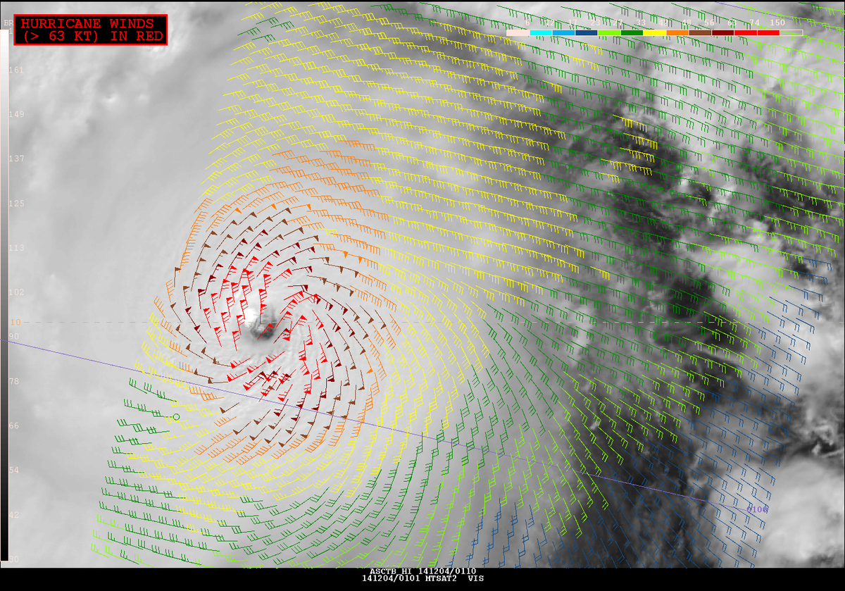
ASCAT just went in: wind field larger than first thought.
https://pbs.twimg.com/media/B3_E4PfCQAAAw4Y.png from OPC Twitter
https://pbs.twimg.com/media/B3_E4PfCQAAAw4Y.png from OPC Twitter
0 likes
Re: WPAC: HAGUPIT - Typhoon
tatertawt24 wrote:Are the Philippines like the worst spot in the entire world for intense cyclones? Off the top of my head, Haiyan, Megi, Bopha... also Angela farther back.
In terms of how often you get hit by intense storms? Yes probably. Taiwan is close too.

0 likes
-
mrbagyo
- Category 5
- Posts: 3963
- Age: 33
- Joined: Thu Apr 12, 2012 9:18 am
- Location: 14.13N 120.98E
- Contact:
Re: WPAC: HAGUPIT - Typhoon
RL3AO wrote:tatertawt24 wrote:Are the Philippines like the worst spot in the entire world for intense cyclones? Off the top of my head, Haiyan, Megi, Bopha... also Angela farther back.
In terms of how often you get hit by intense storms? Yes probably. Taiwan is close too.
Taiwan is the closest, but actually it's not that close.
0 likes
The posts in this forum are NOT official forecast and should not be used as such. They are just the opinion of the poster and may or may not be backed by sound meteorological data. They are NOT endorsed by any professional institution or storm2k.org. For official information, please refer to RSMC, NHC and NWS products.
-
euro6208
Re: WPAC: HAGUPIT - Typhoon
2014DEC04 051400 7.7 904.6 161.0 7.7 7.7 7.7 NO LIMIT OFF OFF 15.24 -81.65 EYE 20 IR 94.9 10.49 -132.40 COMBO MTSAT2 19.1
Solid 7.7...
Solid 7.7...
0 likes


-
dexterlabio
- Category 5
- Posts: 3505
- Joined: Sat Oct 24, 2009 11:50 pm
Haiyan of course was more impressive at her peak than Hagupit, but it looks like this one is a far larger storm when it comes to size/diameter.
0 likes
Personal Forecast Disclaimer:
The posts in this forum are NOT official forecast and should not be used as such. They are just the opinion of the poster and may or may not be backed by sound meteorological data. They are NOT endorsed by any professional institution or storm2k.org. For official information, please refer to the NHC and NWS products.
The posts in this forum are NOT official forecast and should not be used as such. They are just the opinion of the poster and may or may not be backed by sound meteorological data. They are NOT endorsed by any professional institution or storm2k.org. For official information, please refer to the NHC and NWS products.
-
somethingfunny

- ChatStaff

- Posts: 3926
- Age: 37
- Joined: Thu May 31, 2007 10:30 pm
- Location: McKinney, Texas
Hagupit's motion appears to be a steady WNW direction now. Once it clears the latitude of Leyte Gulf and Tacloban we can breathe a small sigh of relief at least for that region and its' inherent storm surge risk.
It's quite unusual in this modern era of forecasting to have such a consistent spread between model forecast tracks so close to (potential) landfall. Tracking this storm will be a nail biter right up to the end.
What are we expecting to happen with Hagupit's structure once it approaches the coastline? Isn't shear still expected to increase and hopefully weaken the typhoon?
If it doesn't cause a recurve (looks increasingly likely that it won't) I suspect that the passing trough might allow Hagupit to grow larger in size but also perhaps weaker in intensity as it stalls off the coast of Samar or Luzon, before resuming the westward or even WSWward movement into the Philippines archipelago. The end result might be a smaller impact from wind and surge than Haiyan had, but catastrophic amounts of rainfall as a very large and very slow moving former supertyphoon makes its way west.
0 likes
I am not a meteorologist, and any posts made by me are not official forecasts or to be interpreted as being intelligent. These posts are just my opinions and are probably silly opinions.
-
dexterlabio
- Category 5
- Posts: 3505
- Joined: Sat Oct 24, 2009 11:50 pm
I don't know what will be the implication of this development, but the 06z GFS run gave in to the Samar landfall. If the same scenario will be shown in the 12z and 18z run, I think we can all say that this typhoon is decided to strike...
0 likes
Personal Forecast Disclaimer:
The posts in this forum are NOT official forecast and should not be used as such. They are just the opinion of the poster and may or may not be backed by sound meteorological data. They are NOT endorsed by any professional institution or storm2k.org. For official information, please refer to the NHC and NWS products.
The posts in this forum are NOT official forecast and should not be used as such. They are just the opinion of the poster and may or may not be backed by sound meteorological data. They are NOT endorsed by any professional institution or storm2k.org. For official information, please refer to the NHC and NWS products.
Who is online
Users browsing this forum: No registered users and 9 guests