Texas Winter 2014-2015

Winter Weather Discussion

Moderator: S2k Moderators

Forum rules

The posts in this forum are NOT official forecast and should not be used as such. They are just the opinion of the poster and may or may not be backed by sound meteorological data. They are NOT endorsed by any professional institution or STORM2K.

Help Support Storm2K
Message
Author
User avatar
srainhoutx
S2K Supporter
S2K Supporter
Posts: 6919
Age: 67
Joined: Sun Jan 14, 2007 11:34 am
Location: Haywood County, NC
Contact:

Re: Re:

#401 Postby srainhoutx » Fri Dec 05, 2014 10:14 am

Big O wrote:
srainhoutx wrote:
Ntxw wrote:The Euro weeklies are shaking things up mid month, CFSv2 still looks warm. The +EPO signal will relax, it's not a strong signal for changes yet but it's moving. The JMA long range is heading towards blocking towards the second half of this month week 3 and 4.

In the very long range, some of the ensemble guidance is hinting towards maybe some possible activity chatter heading towards the holiday frame.


Nice +PNA that has been modeled is certainly showing up nicely via the Euro weeklies around week 3. The pattern is much better in week 4 for an -AO/-EPO regime with a bit of -NOA blocking developing as Christmas nears. The week between Christmas and New Years Day may prove interesting if the longer range ensembles are correct.


Quick question Steve: I have always wondered if it is possible to have a +PNA and -EPO at the same time. What do you think?

Ryan Maue once told me that you can't have a western ridge and eastern blocking. As such, what about the a +PNA, -EPO, -AO, -NAO?

Everyone's thoughts are welcomed.


If you recall we had such a set up in mid November that delivered the extremely cold early season Arctic outbreak across much of North America. Remember the coldest anomalies began in the Inter Mountain West and Plains and slowly spread east after about 5-7 days.

Interesting analysis from Mike Ventrice that is worth mentioning:

http://www.wsi.com/blog/energy/el-nino- ... -just-yet/
0 likes   
Carla/Alicia/Jerry(In The Eye)/Michelle/Charley/Ivan/Dennis/Katrina/Rita/Wilma/Ike/Harvey

Member: National Weather Association
Wx Infinity Forums
http://wxinfinity.com/index.php

Facebook.com/WeatherInfinity
Twitter @WeatherInfinity

aggiecutter
Category 5
Category 5
Posts: 1753
Joined: Thu Oct 14, 2004 9:22 pm
Location: Texarkana

Re: Texas Winter 2014-2015

#402 Postby aggiecutter » Fri Dec 05, 2014 11:41 am

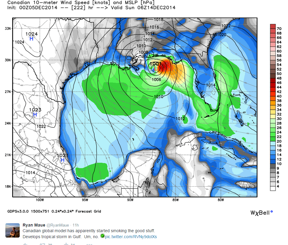
WINTER CANCEL: Tropical season has begun


Image
0 likes   

User avatar
Tireman4
S2K Supporter
S2K Supporter
Posts: 5853
Age: 59
Joined: Fri Jun 30, 2006 1:08 pm
Location: Humble, Texas
Contact:

#403 Postby Tireman4 » Fri Dec 05, 2014 12:07 pm

Woo Hoo.. the Cat 5 in the Gulf. Now we are talking. I was wondering when this would happen. All is right with the world now!!!!!!!!! :uarrow: :lol:
0 likes   

Ralph's Weather
S2K Supporter
S2K Supporter
Posts: 3269
Age: 38
Joined: Fri Dec 13, 2013 11:55 am
Location: Lindale, TX
Contact:

Re: Texas Winter 2014-2015

#404 Postby Ralph's Weather » Fri Dec 05, 2014 12:10 pm

aggiecutter wrote:WINTER CANCEL: Tropical season has begun


Image


Not sure about that one, crazy Canadian. I had been looking for winter to return around then, but hey we mostly missed out on tropical weather so why not.
0 likes   
Follow on Facebook at Ralph's Weather.

User avatar
Portastorm
Storm2k Moderator
Storm2k Moderator
Posts: 9914
Age: 63
Joined: Fri Jul 11, 2003 9:16 am
Location: Round Rock, TX
Contact:

Re: Texas Winter 2014-2015

#405 Postby Portastorm » Fri Dec 05, 2014 12:12 pm

Gotta love the Canadian model. Always good for a hoot. :lol:

It always spins up systems during the tropical season (most of which never materialize) but this seems a little early even by its own standards.
0 likes   
Any forecasts under my name are to be taken with a grain of salt. Get your best forecasts from the National Weather Service and National Hurricane Center.

User avatar
Tireman4
S2K Supporter
S2K Supporter
Posts: 5853
Age: 59
Joined: Fri Jun 30, 2006 1:08 pm
Location: Humble, Texas
Contact:

Re: Texas Winter 2014-2015

#406 Postby Tireman4 » Fri Dec 05, 2014 12:21 pm

Portastorm wrote:Gotta love the Canadian model. Always good for a hoot. :lol:

It always spins up systems during the tropical season (most of which never materialize) but this seems a little early even by its own standards.


The Crazy Canadian. Next thing you know, it will spin up a snowstorm right on top of Austin...he he..I mean...cough..Crazy Canadian.
0 likes   

User avatar
srainhoutx
S2K Supporter
S2K Supporter
Posts: 6919
Age: 67
Joined: Sun Jan 14, 2007 11:34 am
Location: Haywood County, NC
Contact:

Re: Texas Winter 2014-2015

#407 Postby srainhoutx » Fri Dec 05, 2014 12:34 pm

What? No mention of the 12Z GFS in this thread. Nice storm across the Southern Rockies into the Panhandles of TX/OK and much colder air than the warm pattern we are currently witnessing. +PNA with ridging developing into Alaska. Nice pattern transition via the GFS for the cold weather lovers out there. :wink:

Image

Image
0 likes   
Carla/Alicia/Jerry(In The Eye)/Michelle/Charley/Ivan/Dennis/Katrina/Rita/Wilma/Ike/Harvey

Member: National Weather Association
Wx Infinity Forums
http://wxinfinity.com/index.php

Facebook.com/WeatherInfinity
Twitter @WeatherInfinity

User avatar
TheProfessor
Professional-Met
Professional-Met
Posts: 3506
Age: 28
Joined: Tue Dec 03, 2013 10:56 am
Location: Wichita, Kansas

#408 Postby TheProfessor » Fri Dec 05, 2014 1:11 pm

This write up by NWS FWD describes cobblestone ice and how rare it is for it to occur in North Texas, which shows just how rare last years ice storm was. http://www.srh.noaa.gov/fwd/?n=december72013
0 likes   
An alumnus of The Ohio State University.

Your local National Weather Service office is your best source for weather information.

Ralph's Weather
S2K Supporter
S2K Supporter
Posts: 3269
Age: 38
Joined: Fri Dec 13, 2013 11:55 am
Location: Lindale, TX
Contact:

Re:

#409 Postby Ralph's Weather » Fri Dec 05, 2014 1:30 pm

TheProfessor wrote:This write up by NWS FWD describes cobblestone ice and how rare it is for it to occur in North Texas, which shows just how rare last years ice storm was. http://www.srh.noaa.gov/fwd/?n=december72013

Thanks for sharing.
0 likes   
Follow on Facebook at Ralph's Weather.

Nairobi

Re: Texas Winter 2014-2015

#410 Postby Nairobi » Fri Dec 05, 2014 2:10 pm

ECMWF progging a deep trough to approach Texas in about 8 days but without any arctic air to accompany it.

Image
0 likes   

User avatar
gatorcane
S2K Supporter
S2K Supporter
Posts: 23691
Age: 47
Joined: Sun Mar 13, 2005 3:54 pm
Location: Boca Raton, FL

#411 Postby gatorcane » Fri Dec 05, 2014 2:12 pm

The 12Z ECMWF shows nothing but much warmer anomalies for most of the lower 48 and Southern Canada through 10 days.
Last edited by gatorcane on Fri Dec 05, 2014 2:13 pm, edited 1 time in total.
0 likes   

User avatar
TeamPlayersBlue
Category 5
Category 5
Posts: 3445
Joined: Tue Feb 02, 2010 1:44 am
Location: Denver/Applewood, CO

#412 Postby TeamPlayersBlue » Fri Dec 05, 2014 2:12 pm

Been on an MJO fix lately and understanding even more how it works. What are some good sites for information? I think its dominating our weather right now, as i think it typically does in El nino years. Interested in seeing how it effects the weather at the 500 MB level. Right now, the Pacific has so much activity going on and im curious to see how it reacts differently as the MJO approaches phase 7,8,1. Thanks guys! Always learning.
0 likes   
Personal Forecast Disclaimer:
The posts in this forum are NOT official forecast and should not be used as such. They are just the opinion of the poster and may or may not be backed by sound meteorological data. They are NOT endorsed by any professional institution or storm2k.org. For official information, please refer to the NHC and NWS products.

User avatar
Portastorm
Storm2k Moderator
Storm2k Moderator
Posts: 9914
Age: 63
Joined: Fri Jul 11, 2003 9:16 am
Location: Round Rock, TX
Contact:

Re:

#413 Postby Portastorm » Fri Dec 05, 2014 2:24 pm

gatorcane wrote:The 12Z ECMWF shows nothing but much warmer anomalies for most of the lower 48 and Southern Canada through 10 days.


Sorry but that's not entirely accurate. Days 9-10 of the 12z Euro run show normal to below normal for much of the western half of the CONUS.
0 likes   
Any forecasts under my name are to be taken with a grain of salt. Get your best forecasts from the National Weather Service and National Hurricane Center.

User avatar
srainhoutx
S2K Supporter
S2K Supporter
Posts: 6919
Age: 67
Joined: Sun Jan 14, 2007 11:34 am
Location: Haywood County, NC
Contact:

Re: Re:

#414 Postby srainhoutx » Fri Dec 05, 2014 3:08 pm

Portastorm wrote:
gatorcane wrote:The 12Z ECMWF shows nothing but much warmer anomalies for most of the lower 48 and Southern Canada through 10 days.


Sorry but that's not entirely accurate. Days 9-10 of the 12z Euro run show normal to below normal for much of the western half of the CONUS.


It also noteworthy that the 12Z ECMWF suggests the West Coast trough slowly moving E which tend it agree with the OP GFS and GEFS meaning that pattern is beginning to shift. I believe we are on schedule to see an active colder regime along and E of the Continental Divide as we transition in the Christmas Holiday timeframe.
0 likes   
Carla/Alicia/Jerry(In The Eye)/Michelle/Charley/Ivan/Dennis/Katrina/Rita/Wilma/Ike/Harvey

Member: National Weather Association
Wx Infinity Forums
http://wxinfinity.com/index.php

Facebook.com/WeatherInfinity
Twitter @WeatherInfinity

User avatar
MississippiWx
S2K Supporter
S2K Supporter
Posts: 1699
Joined: Sat Aug 14, 2010 1:44 pm
Location: Hattiesburg, Mississippi

Re: Texas Winter 2014-2015

#415 Postby MississippiWx » Fri Dec 05, 2014 4:16 pm

I'm mostly a lurker of this forum, mainly because it's a Texas thing, but those of you who have access to the Euro weeklies should be drooling at what it shows later this month and into January. For those who don't, it shows monster ridging into Alaska and a persistent trough across the United States. Out of respect to Dr. Maue and his site, I will not post his maps. However, they make you do this --->> :eek: :cold: :cold:

Let's hope they pan out! :D
0 likes   
This post is not an official forecast and should not be used as such. It is just the opinion of MississippiWx and may or may not be backed by sound meteorological data. It is not endorsed by any professional institution including storm2k.org. For Official Information please refer to the NHC and NWS products.

User avatar
Portastorm
Storm2k Moderator
Storm2k Moderator
Posts: 9914
Age: 63
Joined: Fri Jul 11, 2003 9:16 am
Location: Round Rock, TX
Contact:

Re: Texas Winter 2014-2015

#416 Postby Portastorm » Fri Dec 05, 2014 4:26 pm

:uarrow:

Thanks for jumping in and offering the information, MississippiWx!

I saw a tweet earlier today from Joe Bastardi that said the CFSv2 for January was looking colder and colder for the central/eastern CONUS every day.
0 likes   
Any forecasts under my name are to be taken with a grain of salt. Get your best forecasts from the National Weather Service and National Hurricane Center.

Nairobi

Re: Texas Winter 2014-2015

#417 Postby Nairobi » Fri Dec 05, 2014 4:29 pm

The Climate Forecasting System is not showing much abnormally cold air for the week after Christmas. Not shown below, but the so-called polar vortex stays locked up around Baffin Bay.

Image
Last edited by Nairobi on Fri Dec 05, 2014 4:44 pm, edited 2 times in total.
0 likes   

User avatar
TeamPlayersBlue
Category 5
Category 5
Posts: 3445
Joined: Tue Feb 02, 2010 1:44 am
Location: Denver/Applewood, CO

Re: Texas Winter 2014-2015

#418 Postby TeamPlayersBlue » Fri Dec 05, 2014 4:40 pm

Nairobi wrote:Not showing much abnormally cold air for the week after Christmas.

[img]http://oi58.tinypic.com/ic64nt .jpg[/img]


Thats not the Euro weekly. Thanks though!
0 likes   
Personal Forecast Disclaimer:
The posts in this forum are NOT official forecast and should not be used as such. They are just the opinion of the poster and may or may not be backed by sound meteorological data. They are NOT endorsed by any professional institution or storm2k.org. For official information, please refer to the NHC and NWS products.

User avatar
Portastorm
Storm2k Moderator
Storm2k Moderator
Posts: 9914
Age: 63
Joined: Fri Jul 11, 2003 9:16 am
Location: Round Rock, TX
Contact:

Re: Texas Winter 2014-2015

#419 Postby Portastorm » Fri Dec 05, 2014 4:42 pm

Here's yet another voice in the growing chorus of weather enthusiasts and experts who are predicting winter returns with a vengeance to much of the nation in January:

http://theweathercentre.blogspot.com/2014/12/new-successful-analog-guidance-predicts.html
0 likes   
Any forecasts under my name are to be taken with a grain of salt. Get your best forecasts from the National Weather Service and National Hurricane Center.

weatherdude1108
Category 5
Category 5
Posts: 4228
Joined: Tue Dec 13, 2011 1:04 pm
Location: Northwest Austin/Cedar Park, TX

#420 Postby weatherdude1108 » Fri Dec 05, 2014 4:54 pm

Here's Hampshire's afternoon discussion.
I am honored that the EWX office has its own "Cavanaugh" :cheesy:
I like the practicality of his last sentence ("ALL
IN ALL THIS WILL BE CLOSE TO SEASONAL NORMALS AND NOT TOO BAD FOR
THIS TIME OF THE YEAR"). Hope he doesn't leave us. Happy Friday!! :wink:

00
FXUS64 KEWX 052109
AFDEWX

AREA FORECAST DISCUSSION
NATIONAL WEATHER SERVICE AUSTIN/SAN ANTONIO TX
309 PM CST FRI DEC 5 2014

.SHORT TERM (TONIGHT THROUGH SATURDAY NIGHT)...
LOW CLOUDS CONTINUE TO BE IN PLACE FOR MOST OF THE REGION WITH THE
CLEARING LINE CURRENTLY EXTENDING FROM DEL RIO TO BURNET. THE
KDFX VAD WIND PROFILE HAS BEEN INDICATING VEERING WINDS ALOFT WITH
NORTH FLOW NOW PRESENT ABOVE 4KFT. THIS IS INDICATIVE OF DRYING
AIR ALOFT WHICH SHOULD SLOWLY CONTINUE TO PUSH THE CLEARING LINE
TO THE SOUTHEAST. THE WIND SHIFT ALOFT IS IN ASSOCIATION WITH A
TROUGH AXIS THAT IS PUSHING EAST OF THE AREA. THIS TROUGH WILL
SEND A WEAK COLD FRONT INTO THE CWA LATE THIS EVENING AND
OVERNIGHT. CURRENTLY THE FRONT WAS LOCATED NEAR A MIDLAND TO
WICHITA FALLS TO OKLAHOMA CITY LINE. THIS FRONT WILL HAVE LITTLE
EFFECT WITH THE MORNING LOWS OR HIGH TEMPERATURES TOMORROW. HIGHS
TOMORROW WILL REACH THE MIDDLE 60S TO LOWER 70S WHICH IS ABOUT A 5
DEGREE DROP ON AVERAGE IN COMPARISON TO TODAY. THERE IS THE
POTENTIAL FOR FOG OR AN ISOLATED SHOWER BEFORE THE FRONT MOVES IN
TONIGHT FOR THE SOUTHEASTERN COUNTIES. THE SOUTHWEST AND WESTERLY
FLOW JUST OFF THE SURFACE SHOULD LIMIT DENSE FOG POTENTIAL. TOMORROW
AND TOMORROW NIGHT SHOULD BE DRY AS SUBSIDENCE TAKES A HOLD AS A
WEAK RIDGE AXIS QUICKLY SLIDES OVER THE REGION BEHIND THE TROUGH.

&&

.LONG TERM (SUNDAY THROUGH FRIDAY)...
THE WEAK RIDGE AXIS WILL QUICKLY SLIDE EAST BY SUNDAY AS ANOTHER
TROUGH MOVES THROUGH THE SOUTHERN PLAINS. MODELS HAVE SOME
DISAGREEMENT REGARDING THE AMOUNT OF MOISTURE AND INSTABILITY
AVAILABLE FOR SHOWER PRODUCTION. THE GFS/ECMWF SHOW A WEAK CAP
AROUND 700 MB THAT WOULD KEEP ANY PRECIPITATION PROCESSES IN THE
LOWEST 3KM OF THE ATMOSPHERE. THIS WOULD THEN LIMIT THE COVERAGE
AND AMOUNTS OF PRECIP. THE NAM DOES NOT SHOW THIS INVERSION AND
THUS HAS MUCH MORE QPF IN THE RAW MODEL OUTPUT. WILL CONTINUE TO
FORECAST AROUND A 30 POP FOR SUNDAY AND SUNDAY NIGHT. EVEN IF THE
NAM VERIFIES AVERAGE PRECIP AMOUNTS WILL GENERALLY BE LESS THAN 2
TENTHS OF AN INCH.

WEAK RIDGING RETURNS MONDAY BEHIND THE SHORTWAVE WHICH SHOULD END
PRECIP CHANCES FOR MOST OF THE AREA. THERE COULD BE SOME LIGHT
RAIN OF DRIZZLE CLOSER TO THE RIO GRANDE WHERE THERE IS BETTER
LOW-LEVEL LAPSE RATES IN A SATURATED LAYER UP TO 800 MB. SEVERAL
WEAK TROUGHS EMBEDDED IN NEARLY ZONAL FLOW WILL LEAD TO CONTINUED
RAIN CHANCES FOR MUCH OF THE CWA TUESDAY THROUGH THURSDAY. FORCING
WILL REMAIN WEAK AND MOISTURE LIMITED...AND AM NOT EXPECTING MUCH
IN THE WAY OF RAIN AMOUNTS. SURFACE FLOW WILL REMAIN SOUTHERLY
WITH TEMPERATURES IN THE 60S FOR HIGHS AND 40S/50S FOR LOWS. ALL
IN ALL THIS WILL BE CLOSE TO SEASONAL NORMALS AND NOT TOO BAD FOR
THIS TIME OF THE YEAR.


HAMPSHIRE
0 likes   
The preceding post is NOT an official forecast, and should not be used as such. It is only the opinion of the poster and may or may not be backed by sound meteorological data. It is NOT endorsed by any professional institution including storm2k.org. For Official Information please refer to the NHC and NWS products.


Return to “Winter Weather”

Who is online

Users browsing this forum: No registered users and 6 guests