Texas Winter 2014-2015

Winter Weather Discussion

Moderator: S2k Moderators

Forum rules

The posts in this forum are NOT official forecast and should not be used as such. They are just the opinion of the poster and may or may not be backed by sound meteorological data. They are NOT endorsed by any professional institution or STORM2K.

Help Support Storm2K
Message
Author
User avatar
Ntxw
Storm2k Moderator
Storm2k Moderator
Posts: 22785
Joined: Wed Oct 21, 2009 6:34 pm
Location: DFW, Texas

Re: Texas Winter 2014-2015

#581 Postby Ntxw » Wed Dec 10, 2014 2:49 pm

TarrantWx wrote:Ntxw,

I'm interested to get your take on the GOA warm pool. I've been watching SST's in the Pacific and noticed that the Gulf of Alaska warm pool anomalies relaxed following the November arctic blast. But I've been noticing that the anomalies are warming up again in the GOA and it looks like it's rebounded quite nicely. Could this contribute to the EPO going negative and the impending pattern change?


Its a factor but it is different than last year. Last year it was THE anomaly so the pattern reflected. It has since morphed into a +PDO signal so its a little different now. The PNA will likely see the bigger values but it still promotes some alaskan ridging. El Nino is a larger influence so everything is transpiring closer to what occured in the later 70s in a similar sst shift.
0 likes   
The above post and any post by Ntxw is NOT an official forecast and should not be used as such. It is just the opinion of the poster and may or may not be backed by sound meteorological data. It is NOT endorsed by any professional institution including Storm2k. For official information, please refer to NWS products.

  Help support Storm2K!
Help Support Storm2K

User avatar
gatorcane
S2K Supporter
S2K Supporter
Posts: 23691
Age: 47
Joined: Sun Mar 13, 2005 3:54 pm
Location: Boca Raton, FL

Re:

#582 Postby gatorcane » Wed Dec 10, 2014 3:05 pm

Big O wrote:JB tweeted the 12z GEFS valid 0z 12/26, and it looks amazing for us in Texas and all areas east of the Continental Divide.

http://t.co/xwk9JdbDlC


Here is the temp anomaly graphic from GEFS for Christmas and trending colder for Texas:

Image
0 likes   

User avatar
gboudx
S2K Supporter
S2K Supporter
Posts: 4080
Joined: Thu Sep 04, 2003 1:39 pm
Location: Rockwall, Tx but from Harvey, La

Re:

#583 Postby gboudx » Wed Dec 10, 2014 3:11 pm

high_lander wrote:Just saw that, while I am dreaming of snow, we are driving down to NOLA on the 26th.

Oof.


We'll be driving down there on the 24th and then back on the 29th. Hoping for no icy roads.
0 likes   

User avatar
gatorcane
S2K Supporter
S2K Supporter
Posts: 23691
Age: 47
Joined: Sun Mar 13, 2005 3:54 pm
Location: Boca Raton, FL

#584 Postby gatorcane » Wed Dec 10, 2014 3:13 pm

GEM is coming in much colder in the long-range. Pattern shift?

Image
0 likes   

Ralph's Weather
S2K Supporter
S2K Supporter
Posts: 3269
Age: 38
Joined: Fri Dec 13, 2013 11:55 am
Location: Lindale, TX
Contact:

Re:

#585 Postby Ralph's Weather » Wed Dec 10, 2014 4:55 pm

gatorcane wrote:GEM is coming in much colder in the long-range. Pattern shift?

Image

It is always nice when the models start to back what we have been thinking for a while.
0 likes   
Follow on Facebook at Ralph's Weather.

User avatar
TeamPlayersBlue
Category 5
Category 5
Posts: 3445
Joined: Tue Feb 02, 2010 1:44 am
Location: Denver/Applewood, CO

#586 Postby TeamPlayersBlue » Wed Dec 10, 2014 5:11 pm

If the cold comes back that week, that would be about 6 weeks since the cold left us
0 likes   
Personal Forecast Disclaimer:
The posts in this forum are NOT official forecast and should not be used as such. They are just the opinion of the poster and may or may not be backed by sound meteorological data. They are NOT endorsed by any professional institution or storm2k.org. For official information, please refer to the NHC and NWS products.

User avatar
JDawg512
Category 5
Category 5
Posts: 1077
Age: 45
Joined: Mon Aug 26, 2013 8:56 pm
Location: Austin
Contact:

Re: Texas Winter 2014-2015

#587 Postby JDawg512 » Wed Dec 10, 2014 5:21 pm

EWX continues to insist the weekend system will stay well north into Kansas. I'm hoping that is not the case since that would deminish rainfall amounts.
0 likes   
Resident Rain Miser

I am a weather hobbyist living 3.5 miles south of Downtown Austin and in no way or fashion should anything I say concerning forecasts be taken seriously. Please check your local NWS for accurate weather forecasting and conditions.

User avatar
Portastorm
Storm2k Moderator
Storm2k Moderator
Posts: 9914
Age: 63
Joined: Fri Jul 11, 2003 9:16 am
Location: Round Rock, TX
Contact:

#588 Postby Portastorm » Wed Dec 10, 2014 8:39 pm

:uarrow:

Yeah I saw that too. The trend is NOT our friend. Hopefully we see a reversal back to a more southerly route.
0 likes   
Any forecasts under my name are to be taken with a grain of salt. Get your best forecasts from the National Weather Service and National Hurricane Center.

User avatar
Ntxw
Storm2k Moderator
Storm2k Moderator
Posts: 22785
Joined: Wed Oct 21, 2009 6:34 pm
Location: DFW, Texas

#589 Postby Ntxw » Wed Dec 10, 2014 8:49 pm

It's interesting on the headlines of this storm coming into California. After the NWS in SF mentioned an "atmospheric river" different terms are making news such as fire-hose, river in the sky etc. Of course for us weather folks it's simply the El Nino subtropical jet :lol:.
0 likes   
The above post and any post by Ntxw is NOT an official forecast and should not be used as such. It is just the opinion of the poster and may or may not be backed by sound meteorological data. It is NOT endorsed by any professional institution including Storm2k. For official information, please refer to NWS products.


  Help support Storm2K!

Help Support Storm2K


User avatar
dhweather
S2K Supporter
S2K Supporter
Posts: 6199
Joined: Sat Aug 14, 2004 9:29 pm
Location: Heath, TX
Contact:

Re:

#590 Postby dhweather » Wed Dec 10, 2014 8:57 pm

gboudx wrote:If you look at the historical lake levels for NCTX, you see steep increases indicating the lakes filled fairly quickly. The most recent I can remember, either 2006 or 2008 I think, Lavon was over 9' low and within a few months time was so high, water was being released downstream. IIRC, most of the rain occurred in the Spring months. Once the ground gets saturated, these lakes fill up fast with additional rainfall.


It was Srping 2008 - it was amazing how the skies opened up. We went from -9 on Lake Lavon to opening floodgates in a matter of weeks.
0 likes   
The above post and any post by dhweather is NOT an official forecast and should not be used as such. It is just the opinion of the poster and may or may not be backed by sound meteorological data. It is NOT endorsed by any professional institution including storm2k.org. For official information, please refer to NWS products.

User avatar
TheProfessor
Professional-Met
Professional-Met
Posts: 3506
Age: 28
Joined: Tue Dec 03, 2013 10:56 am
Location: Wichita, Kansas

#591 Postby TheProfessor » Wed Dec 10, 2014 9:09 pm

:uarrow: Yes I remember early summer 2008 quite well, I went to a church camp near Tulsa Oklahoma, and the lake we were at was like 20-30 ft above normal, the water went up to about the 2nd step from the top of a pier, the whole beach was under water including the rock climbing wall on the beach.
0 likes   
An alumnus of The Ohio State University.

Your local National Weather Service office is your best source for weather information.

User avatar
dhweather
S2K Supporter
S2K Supporter
Posts: 6199
Joined: Sat Aug 14, 2004 9:29 pm
Location: Heath, TX
Contact:

Re: Texas Winter 2014-2015

#592 Postby dhweather » Wed Dec 10, 2014 10:31 pm

JDawg512 wrote:EWX continues to insist the weekend system will stay well north into Kansas. I'm hoping that is not the case since that would deminish rainfall amounts.


I'm counting on it, because it happens 95.98685875% of the time.

:grrr: :grrr: :grrr:
0 likes   
The above post and any post by dhweather is NOT an official forecast and should not be used as such. It is just the opinion of the poster and may or may not be backed by sound meteorological data. It is NOT endorsed by any professional institution including storm2k.org. For official information, please refer to NWS products.

User avatar
dhweather
S2K Supporter
S2K Supporter
Posts: 6199
Joined: Sat Aug 14, 2004 9:29 pm
Location: Heath, TX
Contact:

#593 Postby dhweather » Wed Dec 10, 2014 11:03 pm

I've noticed a strong correlation In the multi decadal oscillation in the Atlantic and multi decadal droughts in Texas.

Lots of Atlantic hurricanes in the 30's, 50's, 2000-2012, same decades we've had bad droughts in Texas.

As NTXW pointed out last year, the Pacific is a major player in Texas weather as well.

So if we can get the Atlantic shut off for tropical activity, maybe we can finally resume normal, or GASP, above normal rainfalls, and I won't cry looking at my dead or dying yard and trees. I lost two more this summer.
0 likes   
The above post and any post by dhweather is NOT an official forecast and should not be used as such. It is just the opinion of the poster and may or may not be backed by sound meteorological data. It is NOT endorsed by any professional institution including storm2k.org. For official information, please refer to NWS products.

User avatar
Rgv20
S2K Supporter
S2K Supporter
Posts: 2466
Age: 38
Joined: Wed Jan 05, 2011 5:42 pm
Location: Edinburg/McAllen Tx

#594 Postby Rgv20 » Thu Dec 11, 2014 1:42 am

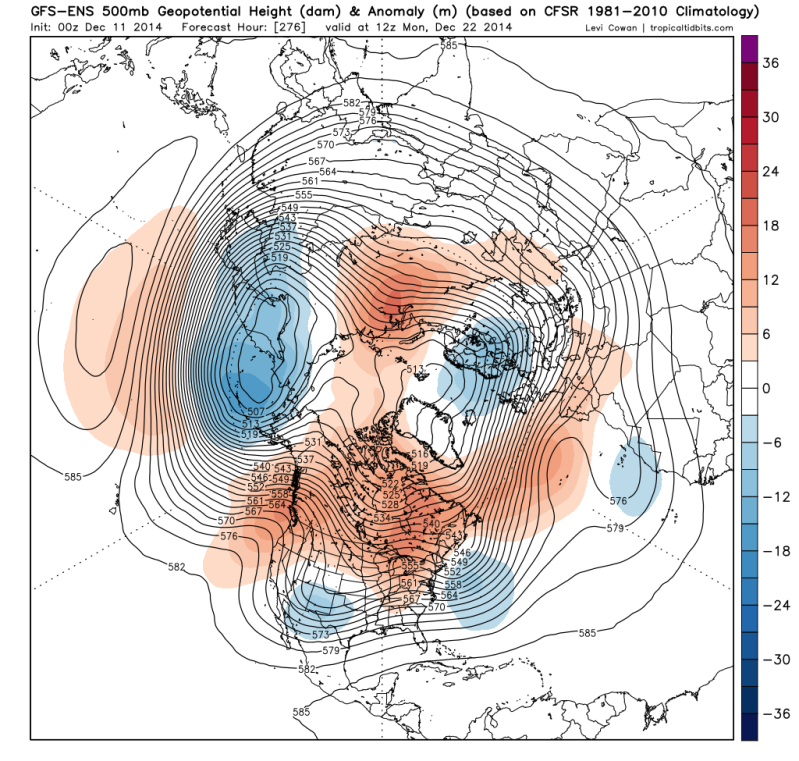
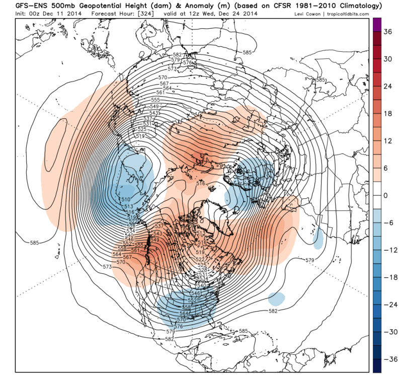
Nice pattern change consistently showing up in the GFS Ensembles as we head to the Holiday Week if you like Winter! :D


0zGFS Ensemble Means 500MB Anomaly for Monday December 22
Image


0zGFS Ensemble Means 500MB Anomaly for Wednesday December 24
Image
0 likes   
The following post is NOT an official forecast and should not be used as such. It is just the opinion of the poster and may or may not be backed by sound meteorological data. It is NOT endorsed by any professional institution including storm2k.org For Official Information please refer to the NHC and NWS products.

weatherdude1108
Category 5
Category 5
Posts: 4228
Joined: Tue Dec 13, 2011 1:04 pm
Location: Northwest Austin/Cedar Park, TX

Re: Texas Winter 2014-2015

#595 Postby weatherdude1108 » Thu Dec 11, 2014 9:42 am

JDawg512 wrote:EWX continues to insist the weekend system will stay well north into Kansas. I'm hoping that is not the case since that would deminish rainfall amounts.


Yeah, wonder why the models have trended that way(?). Earlier this week, I was hoping for just heavy rain and no severe weather. Now, I'm hoping for ANY RAIN.

I'm tired of this mist/drizzle nonsense that has been going on the past week or so. It just dirties the car and causes oily slippery road conditions :roll:

Interesting how much this trough differs in trajectory from the November 22nd trough. Hopefully we can get this parade of troughs going up through the pipeline.
0 likes   

orangeblood
S2K Supporter
S2K Supporter
Posts: 3714
Joined: Tue Dec 15, 2009 6:14 pm
Location: Fort Worth, TX

Re: Texas Winter 2014-2015

#596 Postby orangeblood » Thu Dec 11, 2014 10:11 am

weatherdude1108 wrote:
JDawg512 wrote:EWX continues to insist the weekend system will stay well north into Kansas. I'm hoping that is not the case since that would deminish rainfall amounts.


Yeah, wonder why the models have trended that way(?). Earlier this week, I was hoping for just heavy rain and no severe weather. Now, I'm hoping for ANY RAIN.

I'm tired of this mist/drizzle nonsense that has been going on the past week or so. It just dirties the car and causes oily slippery road conditions :roll:

Interesting how much this trough differs in trajectory from the November 22nd trough. Hopefully we can get this parade of troughs going up through the pipeline.


Don't worry, the Canada to Greenland block is only forecast to intensify, forcing systems much further south, right through the 'pipeline'. All we need is to entrain a little more Arctic Air into the lower 48, this should do the trick....

Image
0 likes   

gpsnowman
S2K Supporter
S2K Supporter
Posts: 3185
Joined: Fri Jan 07, 2011 10:35 am
Location: Grand Prairie Tx

Re: Texas Winter 2014-2015

#597 Postby gpsnowman » Thu Dec 11, 2014 10:12 am

weatherdude1108 wrote:
JDawg512 wrote:EWX continues to insist the weekend system will stay well north into Kansas. I'm hoping that is not the case since that would deminish rainfall amounts.


Yeah, wonder why the models have trended that way(?). Earlier this week, I was hoping for just heavy rain and no severe weather. Now, I'm hoping for ANY RAIN.

I'm tired of this mist/drizzle nonsense that has been going on the past week or so. It just dirties the car and causes oily slippery road conditions :roll:

Interesting how much this trough differs in trajectory from the November 22nd trough. Hopefully we can get this parade of troughs going up through the pipeline.

Agreed. All the cloud cover and leafless trees sure give a winter look. Just gotta be patient to get the feel. I would be very surprised if we are not monitoring something wintry next week for the week after.
0 likes   

User avatar
Portastorm
Storm2k Moderator
Storm2k Moderator
Posts: 9914
Age: 63
Joined: Fri Jul 11, 2003 9:16 am
Location: Round Rock, TX
Contact:

Re: Texas Winter 2014-2015

#598 Postby Portastorm » Thu Dec 11, 2014 10:24 am

gpsnowman wrote:
weatherdude1108 wrote:
JDawg512 wrote:EWX continues to insist the weekend system will stay well north into Kansas. I'm hoping that is not the case since that would deminish rainfall amounts.


Yeah, wonder why the models have trended that way(?). Earlier this week, I was hoping for just heavy rain and no severe weather. Now, I'm hoping for ANY RAIN.

I'm tired of this mist/drizzle nonsense that has been going on the past week or so. It just dirties the car and causes oily slippery road conditions :roll:

Interesting how much this trough differs in trajectory from the November 22nd trough. Hopefully we can get this parade of troughs going up through the pipeline.

Agreed. All the cloud cover and leafless trees sure give a winter look. Just gotta be patient to get the feel. I would be very surprised if we are not monitoring something wintry next week for the week after.


Meanwhile, this bodes well (or at least better) for your folks in North Texas who will have better rain chances that South Central or South Texas. Good luck. We all need it! :wink:
0 likes   
Any forecasts under my name are to be taken with a grain of salt. Get your best forecasts from the National Weather Service and National Hurricane Center.

User avatar
Ntxw
Storm2k Moderator
Storm2k Moderator
Posts: 22785
Joined: Wed Oct 21, 2009 6:34 pm
Location: DFW, Texas

#599 Postby Ntxw » Thu Dec 11, 2014 10:25 am

Nothing new to add to the great posts by many. We are moving through a transitional period of change. These bigger storms means something, if we get lucky something might just be cold enough for the holidays. After that there is very strong agreement on the ensembles of blocking and locking. If you expect winter to end before it begins you will be in for a shock. Those analogs are proving to be money.
0 likes   
The above post and any post by Ntxw is NOT an official forecast and should not be used as such. It is just the opinion of the poster and may or may not be backed by sound meteorological data. It is NOT endorsed by any professional institution including Storm2k. For official information, please refer to NWS products.


  Help support Storm2K!

Help Support Storm2K


User avatar
gatorcane
S2K Supporter
S2K Supporter
Posts: 23691
Age: 47
Joined: Sun Mar 13, 2005 3:54 pm
Location: Boca Raton, FL

#600 Postby gatorcane » Thu Dec 11, 2014 10:33 am

Taking a look at the global models shows no arctic air diving into the lower 48 for the forseeable future. I am inclined to think that with the analogs we should start seeing a change towards the end of this month and into January. If you look back several months going back into the summer, we saw the "polar vortex" even then, last one was in November, so you got to think we will see it return this winter. I am thinking January could be the month we see another whopper coming out of Canada which could send much of the lower 48 east of the Rockies into a deep freeze. Time will tell.
0 likes   


Return to “Winter Weather”

Who is online

Users browsing this forum: No registered users and 10 guests