From Mike Ventrice:
My 6-10 and 11-15 day period discussions from this morning:
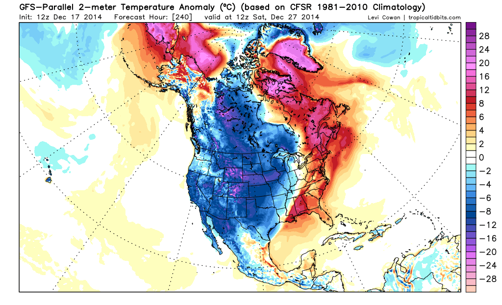
Models have rounded into better agreement this morning, all of which may be contributed to a local cyclonic wave breaking event setting up over the eastern U.S. during the latter half of the 6-10 day period forecast. Models often struggle with these wave breaking events and they have been clearly struggling over the past week as the forecast continues to trend warmer over the East. The latest models are moving away from the idea of a strong coastal "Nor'easter" to impact the coastal east and towards the idea of a major winter storm to impact the Midwest as a highly-anomalous upper-level cold trough digs across the central U.S. The change of pattern is clearly being driven by upstream processes over the Pacific Ocean. We have been locked into an El Nino driven pattern for the good portion of this month. That pattern will be ending during the 6-10 day period forecast, in response to a very deep upper-level cold trough sliding off the coast of Asia, forcing a high-latitude wave anticyclonic breaking event over the North Pacific. This event will result in warm upper-level ridge development over Alaska mid-to-late period, tanking the East Pacific Oscillation (EPO) into negative territory. A direct downstream response will be felt over the U.S., in which some colder air from the north will be able to freely flow down the Rockies and fuel the explosive deepening of a mid-latitude cyclone aiming to take shape over the Midwest and Ohio Valley. The details remain to be panned out, but the synoptic set up is favoring for strong dynamical forcing that results in a winter storm across the major markets in PJM mid-to-late period. A flux of moist tropical air from the east will fuel the system. This plume of mild, moist Atlantic air will result in unseasonably mild temperatures across the Northeastern U.S. around Christmas, setting up a possible heavy rain event for DCA, PHL, NYC in through BOS.
Now while the 6-10 day period forecast has trended warmer in response to this upcoming cyclonic wave breaking event, this particular event (in addition to the upstream forcing) is setting the stage for a major pattern change during the 11-15 day period forecast. With the massive cyclone to spin across the Great Lakes and up through eastern Canada late in the period, it will aid in advecting a highly anomalous cold air mass down the western two thirds of the nation, resulting in well below average temperatures to flood the western two thirds of the nation. We typically see major pattern transitions across the lower 48 following the development a significant mid-latitude cyclone, and this is the anticipated pattern evolution heading into the final week of the month.
11-15 day:
A period of cold weather and high heating demand is anticipated during the 11-15 day period forecast. High latitude blocking will be the theme during late December in through January, with a prominent upper-level warm ridge forecast to spin up over Alaska and build northward in through the North Pole and eastern Siberia. This pattern sets will generate cross polar flow from Siberia in through the U.S. during the time frame, sponsoring a period of well below average temperatures from the Pacific Northwest Basin in through the eastern two thirds of the nation. We have seen a significant shift in the ECMWF EPS towards the GFS model package solution, in which the model is now more aggressive with building a western U.S. ridge and deepening and eastern U.S. trough as heights build across the North Pole. A split of the tropospheric "Polar Vortex" looks prominent, which a lobe will likely spin down across the Hudson Bay and facilitate cold northwesterly flow on its western flank. Coast to coast cold weather will be the rule during the 11-15 day period forecast, impacting all major markets in the U.S. with exception of those in the Southwest.
Now while the state of convection in the tropics, specifically the Madden Julian Oscillation (MJO) is headed for the "Warm USA" phases, it will have no impact on the U.S. pattern as high-latitude blocking will set up over the North-Northeast Pacific, driving a series of arctic air masses down across the U.S. The pattern looks extremely similar to what was observed last winter or back in November, and we should expect a similar outcome... Cold temperatures and increased heating demand. Now while there will likely be some details that remain to be panned out in response to synoptic waves (winter storms) spinning around the U.S., we hold higher than average confidence in the upcoming pattern change that will end in winter-type conditions across the lower 48.
Texas Winter 2014-2015
Moderator: S2k Moderators
Forum rules
 The posts in this forum are NOT official forecast and should not be used as such. They are just the opinion of the poster and may or may not be backed by sound meteorological data. They are NOT endorsed by any professional institution or STORM2K.

The posts in this forum are NOT official forecast and should not be used as such. They are just the opinion of the poster and may or may not be backed by sound meteorological data. They are NOT endorsed by any professional institution or STORM2K.
-
srainhoutx

- S2K Supporter

- Posts: 6919
- Age: 68
- Joined: Sun Jan 14, 2007 11:34 am
- Location: Haywood County, NC
- Contact:
Re: Texas Winter 2014-2015
0 likes
Carla/Alicia/Jerry(In The Eye)/Michelle/Charley/Ivan/Dennis/Katrina/Rita/Wilma/Ike/Harvey
Member: National Weather Association
Wx Infinity Forums
http://wxinfinity.com/index.php
Facebook.com/WeatherInfinity
Twitter @WeatherInfinity
Member: National Weather Association
Wx Infinity Forums
http://wxinfinity.com/index.php
Facebook.com/WeatherInfinity
Twitter @WeatherInfinity
-
Ralph's Weather
- S2K Supporter
- Posts: 3371
- Age: 38
- Joined: Fri Dec 13, 2013 11:55 am
- Location: Lindale, TX
- Contact:
Re: Texas Winter 2014-2015
All of that sounds reasonable and it is a very good set-up for cold around here. Now we just need a system to add some moisture to the mix and we are in business for snow. The post-Christmas period will be a great one for cold weather lovers and hopefully snow lovers also. I would love a repeat of 2009 since I missed most of that being in College Station at the time while Lindale got almost a foot in one storm along with a few other snows.
0 likes
Follow on Facebook at Ralph's Weather.
-
gatorcane

- S2K Supporter
- Posts: 23708
- Age: 48
- Joined: Sun Mar 13, 2005 3:54 pm
- Location: Boca Raton, FL
South Texas Storms wrote:0z Euro is indicating a very cold airmass will move south into Texas in about 10 days. It's showing snow in Oklahoma and the Texas Panhandle as the run ends.
http://i59.tinypic.com/2m31nki.png
I'd say that is a significant artic outbreak heading straight for Texas in that run. The GFS has been showing this artic outbreak invading the U.S. since last week and now with the ECMWF on board, it's looking more likely it will happen.
0 likes
-
cycloneye

- Admin

- Posts: 149453
- Age: 69
- Joined: Thu Oct 10, 2002 10:54 am
- Location: San Juan, Puerto Rico
Re: Texas Winter 2014-2015
El Nino-like Sub-Tropical jet looks great for Texas. 

0 likes
Visit the Caribbean-Central America Weather Thread where you can find at first post web cams,radars
and observations from Caribbean basin members Click Here
and observations from Caribbean basin members Click Here

I'm just not quite ready to buy off on the pattern change. The current pattern has had a strong hold on us since the November cold outbreak.
My Weather-Display software has been having issues as of late, so I went into the Davis Weatherlink software and checked, Sunday/Monday I got a total of 1.20" of liquid gold, which we will always take.
My Weather-Display software has been having issues as of late, so I went into the Davis Weatherlink software and checked, Sunday/Monday I got a total of 1.20" of liquid gold, which we will always take.
0 likes
The above post and any post by dhweather is NOT an official forecast and should not be used as such. It is just the opinion of the poster and may or may not be backed by sound meteorological data. It is NOT endorsed by any professional institution including storm2k.org. For official information, please refer to NWS products.
On a side note, heard on the radio this morning that a flight from Seoul to DFW had to make an emergency landing in Tokyo after encountering severe turbulence, injuring 14 people. This is likely a result of the strong double barreled system taking shape in the far WPAC, I think I was a Maue tweet about that a couple of days ago?
Glad no injuries were too severe or life threatening.
Glad no injuries were too severe or life threatening.
0 likes
The above post and any post by dhweather is NOT an official forecast and should not be used as such. It is just the opinion of the poster and may or may not be backed by sound meteorological data. It is NOT endorsed by any professional institution including storm2k.org. For official information, please refer to NWS products.
-
gboudx

- S2K Supporter
- Posts: 4090
- Joined: Thu Sep 04, 2003 1:39 pm
- Location: Rockwall, Tx but from Harvey, La
Re:
dhweather wrote:On a side note, heard on the radio this morning that a flight from Seoul to DFW had to make an emergency landing in Tokyo after encountering severe turbulence, injuring 14 people. This is likely a result of the strong double barreled system taking shape in the far WPAC, I think I was a Maue tweet about that a couple of days ago?
Glad no injuries were too severe or life threatening.
It was on Fox 4 last night. You know almost every story has a "North Texas" connection to it. There was a guy from this area on the flight and recorded some of the event. Said the turbulence lasted about an hour and flight crew asked for a doctor over the PA for assistance.
0 likes

On a side note, a little over halfway through the month DFW has recorded 1 clear day. How's that for El Nino? Unfortunately this has yet to result in meaningful rainfall as the big airport recorded thus far only 0.14 inches. It has also averaged 5.6F warmer than normal, that will come down the next 2 weeks but still impressive.
Its a good thing 1965, 1976, 1977 had mediocre to mild Decembers otherwise panic abound.
Its a good thing 1965, 1976, 1977 had mediocre to mild Decembers otherwise panic abound.
0 likes
The above post and any post by Ntxw is NOT an official forecast and should not be used as such. It is just the opinion of the poster and may or may not be backed by sound meteorological data. It is NOT endorsed by any professional institution including Storm2k. For official information, please refer to NWS products.
Help support Storm2K!
-
Portastorm

- Storm2k Moderator

- Posts: 9955
- Age: 63
- Joined: Fri Jul 11, 2003 9:16 am
- Location: Round Rock, TX
- Contact:
Re: Re:
gboudx wrote:dhweather wrote:On a side note, heard on the radio this morning that a flight from Seoul to DFW had to make an emergency landing in Tokyo after encountering severe turbulence, injuring 14 people. This is likely a result of the strong double barreled system taking shape in the far WPAC, I think I was a Maue tweet about that a couple of days ago?
Glad no injuries were too severe or life threatening.
It was on Fox 4 last night. You know almost every story has a "North Texas" connection to it. There was a guy from this area on the flight and recorded some of the event. Said the turbulence lasted about an hour and flight crew asked for a doctor over the PA for assistance.
Yes, the turbulence was a result of that very powerful storm system. I saw a flight path map overlaid with satellite. Kinda wonder why the airline's flight planners didn't route around it and am glad I wasn't on that plane! Of course anyone seated with a seat belt was fine ... which is always a good idea when seated in an airborne plane, regardless of whether the "fasten seat belts" light is on or not.
Apparently here is a video on that plane:
https://www.youtube.com/watch?v=V21eV22fYxI
This same storm system produced crazy amounts of snow in parts of Japan, including the city of Hokkaido.
0 likes
Any forecasts under my name are to be taken with a grain of salt. Get your best forecasts from the National Weather Service and National Hurricane Center.
-
gboudx
- S2K Supporter
- Posts: 4090
- Joined: Thu Sep 04, 2003 1:39 pm
- Location: Rockwall, Tx but from Harvey, La
Re: Re:
Portastorm wrote:
Yes, the turbulence was a result of that very powerful storm system. I saw a flight path map overlaid with satellite. Kinda wonder why the airline's flight planners didn't route around it and am glad I wasn't on that plane! Of course anyone seated with a seat belt was fine ... which is always a good idea when seated in an airborne plane, regardless of whether the "fasten seat belts" light is on or not.
Apparently here is a video on that plane:
https://www.youtube.com/watch?v=V21eV22fYxI
This same storm system produced crazy amounts of snow in parts of Japan, including the city of Hokkaido.
Regarding routing around it, the news said that no plane had been on that route to experience the turbulence so that was the reason given for why the plane was routed around it.
0 likes
-
aggiecutter
- Category 5

- Posts: 1755
- Joined: Thu Oct 14, 2004 9:22 pm
- Location: Texarkana
Re: Texas Winter 2014-2015
The 0z EURO flips to a upper air pattern that resembles January-February 1978. Blocking over the top, PNA ridge of the west coast, generally lower heights over much of the contiguous 48, and the subtropical jet undercutting the PNA ridge. That pattern pretty much held true January through Mid-March of 78, resulting in Texarkana getting more than 10 significant winter weather events during that period. If memory serves me correct, the snow and ice that year was severe as far south as the Georgetown-Round Rock area. I think areas south of the there received only a cold rain, although I think I read somewhere that SW Austin received 4 flakes of snow that winter, shutting the city down for a couple days.

0 likes
-
srainhoutx
- S2K Supporter
- Posts: 6919
- Age: 68
- Joined: Sun Jan 14, 2007 11:34 am
- Location: Haywood County, NC
- Contact:
Re: Texas Winter 2014-2015
12Z parallel GFS is dumping a lot of cold air into North American just after Christmas...
0 likes
Carla/Alicia/Jerry(In The Eye)/Michelle/Charley/Ivan/Dennis/Katrina/Rita/Wilma/Ike/Harvey
Member: National Weather Association
Wx Infinity Forums
http://wxinfinity.com/index.php
Facebook.com/WeatherInfinity
Twitter @WeatherInfinity
Member: National Weather Association
Wx Infinity Forums
http://wxinfinity.com/index.php
Facebook.com/WeatherInfinity
Twitter @WeatherInfinity
-
Portastorm
- Storm2k Moderator
- Posts: 9955
- Age: 63
- Joined: Fri Jul 11, 2003 9:16 am
- Location: Round Rock, TX
- Contact:
Re: Texas Winter 2014-2015
aggiecutter wrote:The 0z EURO flips to a upper air pattern that resembles January-February 1978. Blocking over the top, PNA ridge of the west coast, generally lower heights over much of the contiguous 48, and the subtropical jet undercutting the PNA ridge. That pattern pretty much held true January through Mid-March of 78, resulting in Texarkana getting more than 10 significant winter weather events during that period. If memory serves me correct, the snow and ice that year was severe as far south as the Georgetown-Round Rock area. I think areas south of the there received only a cold rain, although I think I read somewhere that SW Austin received 4 flakes of snow that winter, shutting the city down for a couple days.
(image deleted)
You're a real comedian, aren't you aggiecutter?!
If four flakes of snow do fall in SW Austin, I will be there to catch it on video. Otherwise no one would believe me.
Thanks for your post. Very interesting developments.
0 likes
Any forecasts under my name are to be taken with a grain of salt. Get your best forecasts from the National Weather Service and National Hurricane Center.
-
wxman57

- Moderator-Pro Met

- Posts: 23174
- Age: 68
- Joined: Sat Jun 21, 2003 8:06 pm
- Location: Houston, TX (southwest)
Re: Texas Winter 2014-2015
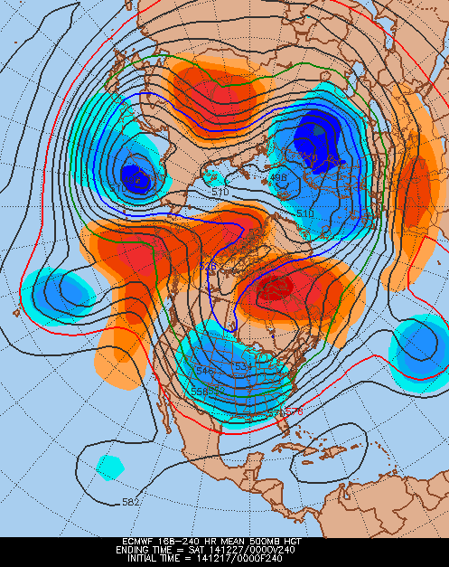
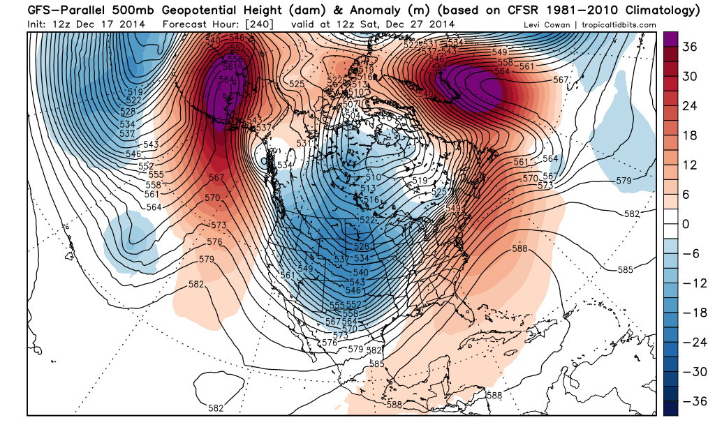
If you look at the loop below, the parallel run of the GFS moves the coldest air into the U.S. on the 22-24. By the 27th, the upper trof is not digging southward, it's lifting northward.
http://www.tropicaltidbits.com/analysis ... lp_us.html
http://www.tropicaltidbits.com/analysis ... lp_us.html
0 likes


Re: Texas Winter 2014-2015
Well it does have some frozen precip near the hill country on the morning of the 27th 
0 likes
Anything I post is my personal opinion and should not used for any type of planning or lifesaving reasons. Please refer to National Weather Service forecasts.
-
srainhoutx
- S2K Supporter
- Posts: 6919
- Age: 68
- Joined: Sun Jan 14, 2007 11:34 am
- Location: Haywood County, NC
- Contact:
Re: Texas Winter 2014-2015
the 12Z GEFS mean is not nearly as progressive as the operation runs regarding the trough for what it's worth.
0 likes
Carla/Alicia/Jerry(In The Eye)/Michelle/Charley/Ivan/Dennis/Katrina/Rita/Wilma/Ike/Harvey
Member: National Weather Association
Wx Infinity Forums
http://wxinfinity.com/index.php
Facebook.com/WeatherInfinity
Twitter @WeatherInfinity
Member: National Weather Association
Wx Infinity Forums
http://wxinfinity.com/index.php
Facebook.com/WeatherInfinity
Twitter @WeatherInfinity
-
Ralph's Weather
- S2K Supporter
- Posts: 3371
- Age: 38
- Joined: Fri Dec 13, 2013 11:55 am
- Location: Lindale, TX
- Contact:
The 0Z Euro looks great for some very cold air moving into Texas by hour 240 with an Arctic front pushing through Texas and very high heights over Alaska. Before that it has a good sharp trough for Christmas Eve. Let's see what the 12Z shows. Besides the typically progressive GFS the other models seem to just about all show troughing down the Rockies for late month.
0 likes
Follow on Facebook at Ralph's Weather.
-
wxman57
- Moderator-Pro Met
- Posts: 23174
- Age: 68
- Joined: Sat Jun 21, 2003 8:06 pm
- Location: Houston, TX (southwest)
Re: Texas Winter 2014-2015
hriverajr wrote:Well it does have some frozen precip near the hill country on the morning of the 27th
That looks like a small patch of light upslope snow into the Midland area. High pressure building over Texas with the storm system in Alabama at the time.

Colder air is indicated over Texas the night of the 23rd and Christmas Eve morning:

0 likes
-
Tireman4

- S2K Supporter
- Posts: 5903
- Age: 60
- Joined: Fri Jun 30, 2006 1:08 pm
- Location: Humble, Texas
- Contact:
Re: Texas Winter 2014-2015
wxman57 wrote:If you look at the loop below, the parallel run of the GFS moves the coldest air into the U.S. on the 22-24. By the 27th, the upper trof is not digging southward, it's lifting northward.
http://www.tropicaltidbits.com/analysis ... lp_us.html
Holding on to the dream of hot weather ain't ya sir...he he
0 likes
-
wxman57
- Moderator-Pro Met
- Posts: 23174
- Age: 68
- Joined: Sat Jun 21, 2003 8:06 pm
- Location: Houston, TX (southwest)
Re:
Ralph's Weather wrote:The 0Z Euro looks great for some very cold air moving into Texas by hour 240 with an Arctic front pushing through Texas and very high heights over Alaska. Before that it has a good sharp trough for Christmas Eve. Let's see what the 12Z shows. Besides the typically progressive GFS the other models seem to just about all show troughing down the Rockies for late month.
I'm looking at a plot of surface temps at 240hrs on the 00Z Euro. Front is across central TX at 6pm on the 26th. Temps 42-45 in the D-FW area, 18-20 in the panhandle, 20-40 across OK, 8-25 across KS, -2 to 15 across NE and -8 to 10 across SD. I'd say that qualifies as fairly cold air. Not sure if it's as cold as what came down in November. Regardless, it looks too cold for me!
Note that a temperature of 18F in Amarillo, as in the 240hr Euro, indicates a temperature of 38F in Houston. You have to add 20F to Amarillo's temperature to drop it down to sea level (Houston). Let's see what the 12Z shows for 12Z on the 27th...
0 likes
Who is online
Users browsing this forum: No registered users and 53 guests