Texas Winter 2014-2015

Winter Weather Discussion

Moderator: S2k Moderators

Forum rules

The posts in this forum are NOT official forecast and should not be used as such. They are just the opinion of the poster and may or may not be backed by sound meteorological data. They are NOT endorsed by any professional institution or STORM2K.

Help Support Storm2K
Message
Author
User avatar
wxman57
Moderator-Pro Met
Moderator-Pro Met
Posts: 22979
Age: 67
Joined: Sat Jun 21, 2003 8:06 pm
Location: Houston, TX (southwest)

Re: Texas Winter 2014-2015

#821 Postby wxman57 » Wed Dec 17, 2014 1:10 pm

Tireman4 wrote:
wxman57 wrote:If you look at the loop below, the parallel run of the GFS moves the coldest air into the U.S. on the 22-24. By the 27th, the upper trof is not digging southward, it's lifting northward.

http://www.tropicaltidbits.com/analysis ... lp_us.html

Holding on to the dream of hot weather ain't ya sir...he he


I'm afraid last Sunday's 80F is the last time I'll see 80F until maybe March. I'm not expecting a winter like '85-'86, when Houston hit the low 90s in February. Now THAT was a winter!
0 likes   

Ralph's Weather
S2K Supporter
S2K Supporter
Posts: 3269
Age: 38
Joined: Fri Dec 13, 2013 11:55 am
Location: Lindale, TX
Contact:

Re: Re:

#822 Postby Ralph's Weather » Wed Dec 17, 2014 1:28 pm

wxman57 wrote:
Ralph's Weather wrote:The 0Z Euro looks great for some very cold air moving into Texas by hour 240 with an Arctic front pushing through Texas and very high heights over Alaska. Before that it has a good sharp trough for Christmas Eve. Let's see what the 12Z shows. Besides the typically progressive GFS the other models seem to just about all show troughing down the Rockies for late month.


I'm looking at a plot of surface temps at 240hrs on the 00Z Euro. Front is across central TX at 6pm on the 26th. Temps 42-45 in the D-FW area, 18-20 in the panhandle, 20-40 across OK, 8-25 across KS, -2 to 15 across NE and -8 to 10 across SD. I'd say that qualifies as fairly cold air. Not sure if it's as cold as what came down in November. Regardless, it looks too cold for me!

If this one is like most Arctic fronts then we will see actual surface temps colder than what the models show, maybe much so.
0 likes   
Follow on Facebook at Ralph's Weather.

User avatar
hriverajr
Professional-Met
Professional-Met
Posts: 786
Joined: Tue Jul 19, 2005 12:16 am

Re: Texas Winter 2014-2015

#823 Postby hriverajr » Wed Dec 17, 2014 1:30 pm

My version of the parallel shows a bit more precip than that, especially at 240 hours.. but as you know so far out..hehe
0 likes   
Anything I post is my personal opinion and should not used for any type of planning or lifesaving reasons. Please refer to National Weather Service forecasts.

Ralph's Weather
S2K Supporter
S2K Supporter
Posts: 3269
Age: 38
Joined: Fri Dec 13, 2013 11:55 am
Location: Lindale, TX
Contact:

#824 Postby Ralph's Weather » Wed Dec 17, 2014 1:46 pm

NWS Shreveport just posted their this week in weather history, the latter half of Dec '83 was brutal with heavy snow mid month followed by two weeks of freezing temps across East Texas and much of the state if I recall. Here is the image they posted showing the heavy snow in our area.

Image
0 likes   

User avatar
gatorcane
S2K Supporter
S2K Supporter
Posts: 23691
Age: 47
Joined: Sun Mar 13, 2005 3:54 pm
Location: Boca Raton, FL

#825 Postby gatorcane » Wed Dec 17, 2014 1:52 pm

12Z GFS 12Z temp map shows the artic blast getting Texas again and really most of the country for that matter. Those are midday temp folks.... :eek: :cold:

Image
0 likes   

User avatar
hriverajr
Professional-Met
Professional-Met
Posts: 786
Joined: Tue Jul 19, 2005 12:16 am

Re:

#826 Postby hriverajr » Wed Dec 17, 2014 1:55 pm

gatorcane wrote:12Z GFS 12Z temp map shows the artic blast getting Texas again and really most of the country for that matter. Those are midday temp folks.... :eek: :cold:

actually 6 am CST
0 likes   

WeatherGuesser
Category 5
Category 5
Posts: 2672
Joined: Tue Jun 29, 2010 6:46 am

#827 Postby WeatherGuesser » Wed Dec 17, 2014 1:57 pm

Have you all heard about the Waco TV Met shot at the KECN station?

http://dfw.cbslocal.com/2014/12/17/waco ... rking-lot/
0 likes   

User avatar
gatorcane
S2K Supporter
S2K Supporter
Posts: 23691
Age: 47
Joined: Sun Mar 13, 2005 3:54 pm
Location: Boca Raton, FL

Re: Re:

#828 Postby gatorcane » Wed Dec 17, 2014 2:00 pm

hriverajr wrote:
gatorcane wrote:12Z GFS 12Z temp map shows the artic blast getting Texas again and really most of the country for that matter. Those are midday temp folks.... :eek: :cold:
actually 6 am CST


Yes that's true, didn't realize thanks for the correction. Came across this link to help with the conversion. Still cold nonetheless!

https://ready.arl.noaa.gov/READYtime.php
0 likes   

User avatar
wxman57
Moderator-Pro Met
Moderator-Pro Met
Posts: 22979
Age: 67
Joined: Sat Jun 21, 2003 8:06 pm
Location: Houston, TX (southwest)

Re: Texas Winter 2014-2015

#829 Postby wxman57 » Wed Dec 17, 2014 2:03 pm

Here's a 12Z GFS meteogram for Houston (IAH on north side). A brief cool-down after Christmas then a warm-up before New Year's. Earlier runs had colder air hanging around into January. Note that the GFS parallel run is much colder for the 23rd-24th across Texas.

Image

Image
0 likes   

User avatar
South Texas Storms
Professional-Met
Professional-Met
Posts: 4227
Joined: Thu Jun 24, 2010 12:28 am
Location: Houston, TX

Re: Texas Winter 2014-2015

#830 Postby South Texas Storms » Wed Dec 17, 2014 2:11 pm

The 12z Euro is similar to it's 0z run with a very cold airmass moving south across TX at the end of the run. It's showing wintry precipitation approaching DFW and the Hill Country as the run ends in about 10 days.
0 likes   

User avatar
wxman57
Moderator-Pro Met
Moderator-Pro Met
Posts: 22979
Age: 67
Joined: Sat Jun 21, 2003 8:06 pm
Location: Houston, TX (southwest)

Re: Texas Winter 2014-2015

#831 Postby wxman57 » Wed Dec 17, 2014 2:19 pm

The snow contours that really matter (12Z Euro 240hrs) are the ones between Midland & Lubbock. That light gray area (WxBell maps) usually translates into nothing. And it looks like all upslope precip as the high builds south into Texas. Storm center is well east of Texas by that time.
0 likes   

weatherdude1108
Category 5
Category 5
Posts: 4228
Joined: Tue Dec 13, 2011 1:04 pm
Location: Northwest Austin/Cedar Park, TX

Re: Texas Winter 2014-2015

#832 Postby weatherdude1108 » Wed Dec 17, 2014 2:33 pm

Portastorm wrote:
aggiecutter wrote:The 0z EURO flips to a upper air pattern that resembles January-February 1978. Blocking over the top, PNA ridge of the west coast, generally lower heights over much of the contiguous 48, and the subtropical jet undercutting the PNA ridge. That pattern pretty much held true January through Mid-March of 78, resulting in Texarkana getting more than 10 significant winter weather events during that period. If memory serves me correct, the snow and ice that year was severe as far south as the Georgetown-Round Rock area. I think areas south of the there received only a cold rain, although I think I read somewhere that SW Austin received 4 flakes of snow that winter, shutting the city down for a couple days.

(image deleted)


You're a real comedian, aren't you aggiecutter?! :lol:

If four flakes of snow do fall in SW Austin, I will be there to catch it on video. Otherwise no one would believe me.

Thanks for your post. Very interesting developments.


That made me laugh out loud. :lol:

That is how this place tends to react to four snowflakes.

Anything more than that would be the Snowpocalypse!
:froze:
Last edited by weatherdude1108 on Wed Dec 17, 2014 2:35 pm, edited 1 time in total.
0 likes   

User avatar
Portastorm
Storm2k Moderator
Storm2k Moderator
Posts: 9914
Age: 63
Joined: Fri Jul 11, 2003 9:16 am
Location: Round Rock, TX
Contact:

Re: Texas Winter 2014-2015

#833 Postby Portastorm » Wed Dec 17, 2014 2:33 pm

wxman57 wrote:The snow contours that really matter (12Z Euro 240hrs) are the ones between Midland & Lubbock. That light gray area (WxBell maps) usually translates into nothing. And it looks like all upslope precip as the high builds south into Texas. Storm center is well east of Texas by that time.


The Portastorm Weather Center super-secret computer model shows upper low energy coming out of Mexico at that time and snowing on the Hill Country and Austin. :cheesy:
0 likes   
Any forecasts under my name are to be taken with a grain of salt. Get your best forecasts from the National Weather Service and National Hurricane Center.

weatherdude1108
Category 5
Category 5
Posts: 4228
Joined: Tue Dec 13, 2011 1:04 pm
Location: Northwest Austin/Cedar Park, TX

#834 Postby weatherdude1108 » Wed Dec 17, 2014 2:55 pm

Thunder here at work and raining right now in north Austin. Shook the building! :eek: Rain nice! :D :lightning: :rain:
0 likes   

User avatar
Texas Snowman
Storm2k Moderator
Storm2k Moderator
Posts: 6179
Joined: Fri Jan 25, 2008 11:29 am
Location: Denison, Texas

Re:

#835 Postby Texas Snowman » Wed Dec 17, 2014 2:58 pm

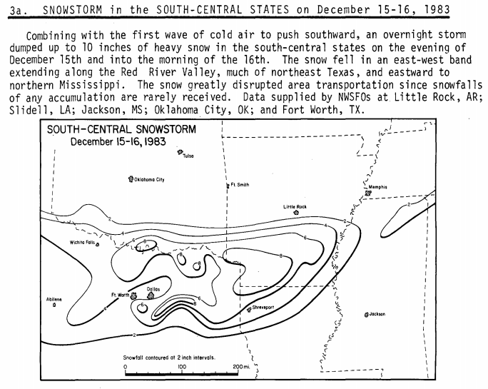
Ralph's Weather wrote:NWS Shreveport just posted their this week in weather history, the latter half of Dec '83 was brutal with heavy snow mid month followed by two weeks of freezing temps across East Texas and much of the state if I recall. Here is the image they posted showing the heavy snow in our area.

Image


Thanks for posting that Ralph's Weather! The Fort Worth NWS office's two or three sentence paragraph about the event the other day didn't even mention the big snowfall amounts recorded up here along the Red River in the Gainesville/Denison/Sherman area. I've read their brief account of that snowstorm before and I have to admit that I was wondering if I was remembering the event for being bigger than it actually was.

I was a senior at Denison High School and I worked evenings in nearby Sherman. When I got out of school, we only had a 20-30% chance of light snow with no significant accumulation expected according to NWS. I told my mom that I was convinced it was going to snow and snow big. I went to work and by the time it was time to drive home, it was coming down heavily. It was the first time I had ever driven in snow and my mom was scared to death (no cell phones back then)!

Moderate to heavy snow fell throughout much of the night and we ended up with 6-8" here in Denison. I remember how beautiful it was the next morning, how Christmas-like it seemed. Bummer was that we had to go to school - if you could make it the superintendent said - because it was the last day before Christmas break. Massive, massive, massive snowball fights erupted between every class change that day. It was one of the most fun days I ever had in school!

It was a beautiful, heavy snowfall but unlike a lot of others, it didn't melt away. The great Dec. 1983 cold wave had begun and the snow stuck around for several days, eventually sublimating into nothing after the long lasting and intense cold. It snowed another time or two during that nearly two week long cold snap, but it was light and wispy stuff, nothing that ever really amounted to much. Eventually, the real story wasn't the snow but the length of the cold, the 290+ hours below freezing, the pipes and water mains bursting, the demand on the power grid and area lakes freezing over.

I'll never forget that snow event or the cold wave that followed, the greatest of the latter part of the 20th century in North Texas. It helped spawn my love of winter weather, especially around Christmas time.

And every year since then, I eagerly hope for a repeat of one of the biggest and best winter weather events of my lifetime! :froze: :cold: :D
0 likes   
The above post and any post by Texas Snowman is NOT an official forecast and should not be used as such. It is just the opinion of the poster and may or may not be backed by sound meteorological data. It is NOT endorsed by any professional institution including storm2k.org. For official information, please refer to NWS products.

User avatar
gatorcane
S2K Supporter
S2K Supporter
Posts: 23691
Age: 47
Joined: Sun Mar 13, 2005 3:54 pm
Location: Boca Raton, FL

#836 Postby gatorcane » Wed Dec 17, 2014 3:40 pm

GEM model also showing the arctic intrusion though slower in it's progression south than the ECMWF:

Image
0 likes   

Ralph's Weather
S2K Supporter
S2K Supporter
Posts: 3269
Age: 38
Joined: Fri Dec 13, 2013 11:55 am
Location: Lindale, TX
Contact:

Re:

#837 Postby Ralph's Weather » Wed Dec 17, 2014 3:47 pm

gatorcane wrote:GEM model also showing the arctic intrusion though slower in it's progression south than the ECMWF:

Image

I like that look cold Plains means continued cold air supply near the surface and cold in the Southwest means upper level storms off of the Pacific. Combined that should yield winter weather.
0 likes   
Follow on Facebook at Ralph's Weather.

User avatar
TheProfessor
Professional-Met
Professional-Met
Posts: 3506
Age: 28
Joined: Tue Dec 03, 2013 10:56 am
Location: Wichita, Kansas

#838 Postby TheProfessor » Wed Dec 17, 2014 4:11 pm

Wow I'm just sitting here in my off period by our court yard in our school and almost instantaneously hail and heavy rain starts coming down. Probably one of the coolest things I've ever seen. :eek:
0 likes   
An alumnus of The Ohio State University.

Your local National Weather Service office is your best source for weather information.

User avatar
CaptinCrunch
S2K Supporter
S2K Supporter
Posts: 8728
Age: 57
Joined: Mon Nov 03, 2003 4:33 pm
Location: Kennedale, TX (Tarrant Co.)

#839 Postby CaptinCrunch » Wed Dec 17, 2014 4:13 pm

Raining here in FTW, very nice to see..... :ggreen:
0 likes   

User avatar
gatorcane
S2K Supporter
S2K Supporter
Posts: 23691
Age: 47
Joined: Sun Mar 13, 2005 3:54 pm
Location: Boca Raton, FL

#840 Postby gatorcane » Wed Dec 17, 2014 4:43 pm

I would say this setup as shown by the 12Z ECMWF should funnel in extreme cold down the back side of that monster low over the Great lakes:


168 hours:
Image

192 hours:
Image
Last edited by gatorcane on Wed Dec 17, 2014 4:45 pm, edited 2 times in total.
0 likes   


Return to “Winter Weather”

Who is online

Users browsing this forum: No registered users and 7 guests