This is kind of Winter-related being that holiday lights are usually during the Winter months. Interesting blog from Bob Rose on the holiday light intensity from space!
http://www.lcra.org/water/river-and-wea ... ather.aspx
Texas Winter 2014-2015
Moderator: S2k Moderators
Forum rules
 The posts in this forum are NOT official forecast and should not be used as such. They are just the opinion of the poster and may or may not be backed by sound meteorological data. They are NOT endorsed by any professional institution or STORM2K.

The posts in this forum are NOT official forecast and should not be used as such. They are just the opinion of the poster and may or may not be backed by sound meteorological data. They are NOT endorsed by any professional institution or STORM2K.
-
weatherdude1108
- Category 5

- Posts: 4228
- Joined: Tue Dec 13, 2011 1:04 pm
- Location: Northwest Austin/Cedar Park, TX
0 likes
The preceding post is NOT an official forecast, and should not be used as such. It is only the opinion of the poster and may or may not be backed by sound meteorological data. It is NOT endorsed by any professional institution including storm2k.org. For Official Information please refer to the NHC and NWS products.
-
srainhoutx

- S2K Supporter

- Posts: 6919
- Age: 68
- Joined: Sun Jan 14, 2007 11:34 am
- Location: Haywood County, NC
- Contact:
Re: Texas Winter 2014-2015
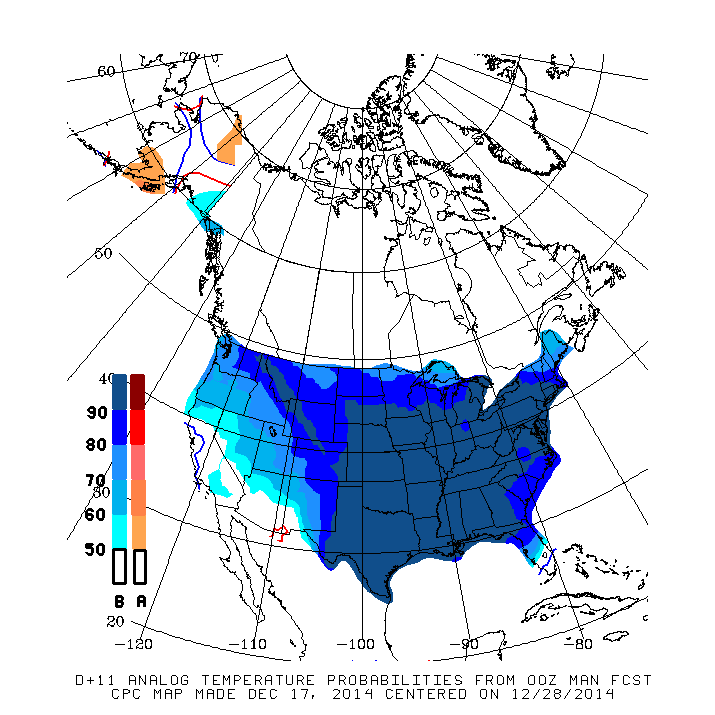
The Day 11+ Analogs continue to advertise a big pattern change as we end December and head into the New Year.

0 likes
Carla/Alicia/Jerry(In The Eye)/Michelle/Charley/Ivan/Dennis/Katrina/Rita/Wilma/Ike/Harvey
Member: National Weather Association
Wx Infinity Forums
http://wxinfinity.com/index.php
Facebook.com/WeatherInfinity
Twitter @WeatherInfinity
Member: National Weather Association
Wx Infinity Forums
http://wxinfinity.com/index.php
Facebook.com/WeatherInfinity
Twitter @WeatherInfinity

After looking over the 12Z models, here's my .02
There will not be significant amounts of precipitation in North Texas in the next 10 days
Temps will be around 20F above normal as we approach Christmas
Right after Christmas, it gets much colder, temps will be around 20F below normal
There is a ZERO percent chance of a white (or wet) Christmas in North Texas, in my opinion.
0 likes
The above post and any post by dhweather is NOT an official forecast and should not be used as such. It is just the opinion of the poster and may or may not be backed by sound meteorological data. It is NOT endorsed by any professional institution including storm2k.org. For official information, please refer to NWS products.
-
gatorcane

- S2K Supporter
- Posts: 23708
- Age: 48
- Joined: Sun Mar 13, 2005 3:54 pm
- Location: Boca Raton, FL
Re:
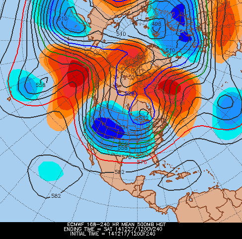
gatorcane wrote:I would say this setup as shown by the 12Z ECMWF should funnel in extreme cold down the back side of that monster low over the Great lakes:
168 hours:
http://i57.tinypic.com/302sz6d.gif
192 hours:
http://i60.tinypic.com/2ngsh93.gif
NWS Albany draws similarities to what the 12Z ECMWF is showing to the Great Appalachian storm of 1950 as well as the "Cleveland Bomb" OF 1978
Details in this thread:
viewtopic.php?f=22&t=116504&st=0&sk=t&sd=a&start=20
0 likes
-
CaptinCrunch

- S2K Supporter
- Posts: 8779
- Age: 58
- Joined: Mon Nov 03, 2003 4:33 pm
- Location: Kennedale, TX (Tarrant Co.)
Re:
dhweather wrote:After looking over the 12Z models, here's my .02
There will not be significant amounts of precipitation in North Texas in the next 10 days
Temps will be around 20F above normal as we approach Christmas
Right after Christmas, it gets much colder, temps will be around 20F below normal
There is a ZERO percent chance of a white (or wet) Christmas in North Texas, in my opinion.
from the NWS FTW forecast thru Christmas Eve the warmest day in the 7 day forecast will be Monday with a high of 63, otherwise temps remain in the 50's with nightly lows in the upper 30's. Christmas Eve H58/L38 which is only a few degrees above the average high of 52 for late December.
0 likes
-
aggiecutter
- Category 5
- Posts: 1755
- Joined: Thu Oct 14, 2004 9:22 pm
- Location: Texarkana
Re: Texas Winter 2014-2015
12z EURO continues its January-February 78' look. If this pattern locks in, I-20 and I-30 will be skating rinks by mid January:

0 likes
-
Texas Snowman

- Storm2k Moderator

- Posts: 6197
- Joined: Fri Jan 25, 2008 11:29 am
- Location: Denison, Texas
Lovely bike riding weather today in Denison. It's POURING down rain here right now. And it's been 39 degrees most of the afternoon. About 2/3 an inch so far with lots of ponding and runoff this afternoon. Even thunder at times.
If only it was 29 degrees!
If only it was 29 degrees!
0 likes
The above post and any post by Texas Snowman is NOT an official forecast and should not be used as such. It is just the opinion of the poster and may or may not be backed by sound meteorological data. It is NOT endorsed by any professional institution including storm2k.org. For official information, please refer to NWS products.
Just re-read most of the posts leading up to and during the Christmas Eve snowstorm 2009. Man, that was an awesome storm! I was not part of Storm2k then but it sure looked like good times on the forum. And I realize how much I miss seeing snow falling. Aggiecutters map sure looks promising. Pouring down here is Grand Prairie though it has let up a bit. Good to have some rain. Bring on winter!!!!!
0 likes
-
Texas Snowman
- Storm2k Moderator
- Posts: 6197
- Joined: Fri Jan 25, 2008 11:29 am
- Location: Denison, Texas
Pouring down rain again here in Denison. Good soaking rain in the Red River Valley this afternoon.
Just saw an interesting post on a friend's Facebook page. Have never heard this "weatherism" before.
"Mama always said if it thunders in December, it will snow in February. Time will tell."
Wonder what the origins of this saying stem from? A weak El Nino year with bleeding cold and an active subtropical jet?
0 likes
The above post and any post by Texas Snowman is NOT an official forecast and should not be used as such. It is just the opinion of the poster and may or may not be backed by sound meteorological data. It is NOT endorsed by any professional institution including storm2k.org. For official information, please refer to NWS products.
-
ThunderSleetDreams

- S2K Supporter
- Posts: 1510
- Age: 43
- Joined: Tue Dec 20, 2011 4:42 pm
- Location: S of Weimar, TX
Re: Texas Winter 2014-2015
Liking the idea of a 78 Winter
0 likes
#NeverSummer
I hibernate when it gets above 75 degrees!
I hibernate when it gets above 75 degrees!

I still wouldn't sleep on the storm around Christmas +-. The models look dry, but that is one heck of low heights and a deep trof with a lot of 5h energy. It also looks warm at the surface but then again so did today and we know how that turned out, late last week GFS had us what 60 for today? The ENS are deep.
0 likes
The above post and any post by Ntxw is NOT an official forecast and should not be used as such. It is just the opinion of the poster and may or may not be backed by sound meteorological data. It is NOT endorsed by any professional institution including Storm2k. For official information, please refer to NWS products.
Help support Storm2K!
-
Rgv20

- S2K Supporter
- Posts: 2466
- Age: 39
- Joined: Wed Jan 05, 2011 5:42 pm
- Location: Edinburg/McAllen Tx
12zECMWF Ensemble Control run forecast some very cold air for the weekend of the 27&28...even has some frozen precipitation for Deep South Texas come Monday the 29th!
0 likes
The following post is NOT an official forecast and should not be used as such. It is just the opinion of the poster and may or may not be backed by sound meteorological data. It is NOT endorsed by any professional institution including storm2k.org For Official Information please refer to the NHC and NWS products.
-
GRAYSONCO.WX
- Category 1

- Posts: 450
- Joined: Thu Jan 06, 2011 4:29 pm
- Location: Denison, Texas
Re: Texas Winter 2014-2015
It looks like the 00Z NAM is hinting at some wrap-around precipitation developing Friday evening. It appears too warm for any wintry weather, but it will be interesting to see if this is a trend and to closely watch temperatures
0 likes
-
somethingfunny

- ChatStaff

- Posts: 3926
- Age: 37
- Joined: Thu May 31, 2007 10:30 pm
- Location: McKinney, Texas
Re:
Texas Snowman wrote:Pouring down rain again here in Denison. Good soaking rain in the Red River Valley this afternoon.
Just saw an interesting post on a friend's Facebook page. Have never heard this "weatherism" before.
"Mama always said if it thunders in December, it will snow in February. Time will tell."
Wonder what the origins of this saying stem from? A weak El Nino year with bleeding cold and an active subtropical jet?
That's a neat weatherism! I've gotta question it though... because we had a tornado in Denison in December 2008, but as far as I recall the 08-09 winter featured a whole lotta nothing. I think we had a light freezing rain event sometime in January and that was it. :p
0 likes
I am not a meteorologist, and any posts made by me are not official forecasts or to be interpreted as being intelligent. These posts are just my opinions and are probably silly opinions.
-
Texas Snowman
- Storm2k Moderator
- Posts: 6197
- Joined: Fri Jan 25, 2008 11:29 am
- Location: Denison, Texas
Re: Re:
somethingfunny wrote:Texas Snowman wrote:Pouring down rain again here in Denison. Good soaking rain in the Red River Valley this afternoon.
Just saw an interesting post on a friend's Facebook page. Have never heard this "weatherism" before.
"Mama always said if it thunders in December, it will snow in February. Time will tell."
Wonder what the origins of this saying stem from? A weak El Nino year with bleeding cold and an active subtropical jet?
That's a neat weatherism! I've gotta question it though... because we had a tornado in Denison in December 2008, but as far as I recall the 08-09 winter featured a whole lotta nothing. I think we had a light freezing rain event sometime in January and that was it. :p
Remember that tornado well. It hit my sister's in-law's house over by the high school as it hopscotched through town, high the house next to a friend of mine, hit our football coach's house and destroyed the bowling alley in town (among other things). Fortunately, it wasn't on the ground all of the time on its journey across town and no one was seriously injured.
0 likes
The above post and any post by Texas Snowman is NOT an official forecast and should not be used as such. It is just the opinion of the poster and may or may not be backed by sound meteorological data. It is NOT endorsed by any professional institution including storm2k.org. For official information, please refer to NWS products.
-
somethingfunny
- ChatStaff
- Posts: 3926
- Age: 37
- Joined: Thu May 31, 2007 10:30 pm
- Location: McKinney, Texas
Re: Re:
Texas Snowman wrote:
Remember that tornado well. It hit my sister's in-law's house over by the high school as it hopscotched through town, high the house next to a friend of mine, hit our football coach's house and destroyed the bowling alley in town (among other things). Fortunately, it wasn't on the ground all of the time on its journey across town and no one was seriously injured.
The sheet metal factory (in a building made of sheet metal) was absolutely terrifying. It's a real miracle nobody was seriously injured with sheet metal whipping through the neighborhood like that - even as "just an EF1" that could have been a very horrific situation.
That night was also the first time anybody outside of the Denison FD found out that the city's tornado sirens weren't working.
0 likes
I am not a meteorologist, and any posts made by me are not official forecasts or to be interpreted as being intelligent. These posts are just my opinions and are probably silly opinions.
-
wxman57

- Moderator-Pro Met

- Posts: 23174
- Age: 68
- Joined: Sat Jun 21, 2003 8:06 pm
- Location: Houston, TX (southwest)
Re: Texas Winter 2014-2015
The 00Z Euro is forecasting a 78 winter for Dallas-Ft. Worth - 78F, that is, on the 26th. It really backed off on any significant cold in the current run. GFS, too.
0 likes

-
weatherdude1108
- Category 5
- Posts: 4228
- Joined: Tue Dec 13, 2011 1:04 pm
- Location: Northwest Austin/Cedar Park, TX
Reading the EWX discussion (not Hampshire). Came across this:
VERTICAL TOTALS LOOK TO INCREASE INTO THE 26-29C RANGE WITH
IMPRESSIVE -2 TO -5 NEGATIVE SHOWALTERS COUPLED WITH 60-70 KT 0-6 KM
SHEAR WILL SUPPORT A MARGINAL HAIL RISK INITIALLY AROUND MIDNIGHT.
("What???") Vertical totals and showalters?
I feel like the guy in class who is lost.

AREA FORECAST DISCUSSION
NATIONAL WEATHER SERVICE AUSTIN/SAN ANTONIO TX
544 AM CST THU DEC 18 2014.PREV DISCUSSION... /ISSUED 439 AM CST THU DEC 18 2014/
..PERIODS OF HEAVY RAIN EXPECTED OVERNIGHT...
SHORT TERM (TODAY THROUGH FRIDAY)...
MAIN FOCUS WILL CENTER ON NEXT 24-36 HOURS WHERE PERIODS OF HEAVY
RAIN WILL BE LIKELY FOR AREAS ALONG AND SOUTHEAST OF A PLEASANTON TO
GEORGETOWN LINE BEGINNING LATE TONIGHT THROUGH MID MORNING FRIDAY.
OVERALL ACCUMULATIONS NEAR 2 INCHES WITH LOCAL AREAS REACHING NEAR 3
INCHES SHOULD BE GREATEST ACROSS THE INLAND COASTAL PRAIRIES AND
SLOWLY TAPERING LOWER INTO THE 1-2 INCH RANGE TOWARDS THE I-35
CORRIDOR. SOME LOCALIZED FLASH FLOODING OR URBAN FLOODING COULD
OCCUR IF ENOUGH STORM TRAINING OCCURS.
FOR THIS MORNING, LIGHT SCATTERED SHOWERS AND DRIZZLE ARE SLOWLY
SHIFTING EAST ACROSS THE REGION WITH LIGHT DRIZZLE REMAINING
POSSIBLE THROUGH THE EARLY MORNING HOURS FOR MAINLY THE I-35
CORRIDOR AND AREAS EAST. AREAS OF FOG ARE ALSO ONGOING EARLY THIS
MORNING WITH SOME LOCALS SEEING DENSE FOG. FOG WILL IMPROVE THROUGH
THE EARLY TO MID MORNING. EXPECT A LULL IN ACTIVITY THROUGH MID
MORNING TO EARLY AFTERNOON WITH MOST SHOWER ACTIVITY RESIDING
TOWARDS THE TX COAST. THIS ACTIVITY HOWEVER WILL BEGIN TO MIGRATE
NORTHWARD AND BLOSSOM OVER THE REGION BY TONIGHT AS UPPER LEVEL
DIVERGENCE INCREASES WITH THE APPROACH OF POTENT SHORTWAVE TROUGH.
AS FAR AS WEATHER EVOLUTION TODAY AND OVERNIGHT, SHOWERS WILL
INITIALLY MOVE NORTH INTO SOUTHERN ZONES FROM SOUTH TEXAS LATE THIS
AFTERNOON. AS THE SHORTWAVE TROUGH PIVOTS TOWARDS THE REGION
TONIGHT, AND INVERTED SURFACE TROUGH AND EVENTUAL CLOSED LOW WILL
AID MOIST SE FLOW INTO THE RIO GRANDE VALLEY. THIS ADDITIONAL
MOISTURE UNDERNEATH AN ELEVATED COOLER CORE POCKET WILL INCREASE
BOTH SURFACE AND ELEVATED INSTABILITY FOR WESTERN LOCATIONS.
VERTICAL TOTALS LOOK TO INCREASE INTO THE 26-29C RANGE WITH
IMPRESSIVE -2 TO -5 NEGATIVE SHOWALTERS COUPLED WITH 60-70 KT 0-6 KM
SHEAR WILL SUPPORT A MARGINAL HAIL RISK INITIALLY AROUND MIDNIGHT.
THIS RISK WILL DECREASE INTO EARLY MORNING AS BAROCLINIC ZONE
FOCUSES FARTHER EAST. THE MAIN FOCUS OF IMPACTS FROM THIS SYSTEM
WILL BE THE BLOSSOMING OF SHOWER AND THUNDERSTORM ACTIVITY BY
MIDNIGHT ACROSS SOUTH-CENTRAL AND SOUTHEAST ZONES. OF HIGHEST
CONCERN WILL BE THE INLAND COASTAL PRAIRIE COUNTIES WHERE HI-RES
GUIDANCE AND SPC SSEO OUTPUT SUGGEST GREATEST RAIN TOTALS IN THE 2-3
INCH REALM COULD BE LOCATED. OVERALL GFS AND GFS-PARALLEL TRENDS
HAVE ALSO FOCUSED IN THIS VICINITY WITH LESSER OVERALL AMOUNTS WEST
OF HWY 281 AND AMOUNTS TAPERING LOWER TOWARDS THE I-35 CORRIDOR. IF
SURFACE LOW DEVELOPS FARTHER SOUTH OR EAST, EVEN LOWER AMOUNTS FOR
THE I-35 CORRIDOR COULD OCCUR AS MOISTURE FLUX BECOMES DECREASED BY
BEING BLOCKED CLOSER TO THE COAST. HAVE PLACED GREATEST POPS IN
DURING THE MIDNIGHT TO 6AM TIMEFRAME WITH A RAMP UP AND RAMP DOWN
FOR THE PRE AND POST 3 HOUR TIME STEPS. SHOWER AND THUNDERSTORM
ACTIVITY WILL DECREASE AND MOVE EAST THROUGH MID MORNING FRIDAY WITH
MOST, IF NOT ALL, ACTIVITY EAST BY EARLY AFTERNOON. /ALLEN/
VERTICAL TOTALS LOOK TO INCREASE INTO THE 26-29C RANGE WITH
IMPRESSIVE -2 TO -5 NEGATIVE SHOWALTERS COUPLED WITH 60-70 KT 0-6 KM
SHEAR WILL SUPPORT A MARGINAL HAIL RISK INITIALLY AROUND MIDNIGHT.
("What???") Vertical totals and showalters?
I feel like the guy in class who is lost.
AREA FORECAST DISCUSSION
NATIONAL WEATHER SERVICE AUSTIN/SAN ANTONIO TX
544 AM CST THU DEC 18 2014.PREV DISCUSSION... /ISSUED 439 AM CST THU DEC 18 2014/
..PERIODS OF HEAVY RAIN EXPECTED OVERNIGHT...
SHORT TERM (TODAY THROUGH FRIDAY)...
MAIN FOCUS WILL CENTER ON NEXT 24-36 HOURS WHERE PERIODS OF HEAVY
RAIN WILL BE LIKELY FOR AREAS ALONG AND SOUTHEAST OF A PLEASANTON TO
GEORGETOWN LINE BEGINNING LATE TONIGHT THROUGH MID MORNING FRIDAY.
OVERALL ACCUMULATIONS NEAR 2 INCHES WITH LOCAL AREAS REACHING NEAR 3
INCHES SHOULD BE GREATEST ACROSS THE INLAND COASTAL PRAIRIES AND
SLOWLY TAPERING LOWER INTO THE 1-2 INCH RANGE TOWARDS THE I-35
CORRIDOR. SOME LOCALIZED FLASH FLOODING OR URBAN FLOODING COULD
OCCUR IF ENOUGH STORM TRAINING OCCURS.
FOR THIS MORNING, LIGHT SCATTERED SHOWERS AND DRIZZLE ARE SLOWLY
SHIFTING EAST ACROSS THE REGION WITH LIGHT DRIZZLE REMAINING
POSSIBLE THROUGH THE EARLY MORNING HOURS FOR MAINLY THE I-35
CORRIDOR AND AREAS EAST. AREAS OF FOG ARE ALSO ONGOING EARLY THIS
MORNING WITH SOME LOCALS SEEING DENSE FOG. FOG WILL IMPROVE THROUGH
THE EARLY TO MID MORNING. EXPECT A LULL IN ACTIVITY THROUGH MID
MORNING TO EARLY AFTERNOON WITH MOST SHOWER ACTIVITY RESIDING
TOWARDS THE TX COAST. THIS ACTIVITY HOWEVER WILL BEGIN TO MIGRATE
NORTHWARD AND BLOSSOM OVER THE REGION BY TONIGHT AS UPPER LEVEL
DIVERGENCE INCREASES WITH THE APPROACH OF POTENT SHORTWAVE TROUGH.
AS FAR AS WEATHER EVOLUTION TODAY AND OVERNIGHT, SHOWERS WILL
INITIALLY MOVE NORTH INTO SOUTHERN ZONES FROM SOUTH TEXAS LATE THIS
AFTERNOON. AS THE SHORTWAVE TROUGH PIVOTS TOWARDS THE REGION
TONIGHT, AND INVERTED SURFACE TROUGH AND EVENTUAL CLOSED LOW WILL
AID MOIST SE FLOW INTO THE RIO GRANDE VALLEY. THIS ADDITIONAL
MOISTURE UNDERNEATH AN ELEVATED COOLER CORE POCKET WILL INCREASE
BOTH SURFACE AND ELEVATED INSTABILITY FOR WESTERN LOCATIONS.
VERTICAL TOTALS LOOK TO INCREASE INTO THE 26-29C RANGE WITH
IMPRESSIVE -2 TO -5 NEGATIVE SHOWALTERS COUPLED WITH 60-70 KT 0-6 KM
SHEAR WILL SUPPORT A MARGINAL HAIL RISK INITIALLY AROUND MIDNIGHT.
THIS RISK WILL DECREASE INTO EARLY MORNING AS BAROCLINIC ZONE
FOCUSES FARTHER EAST. THE MAIN FOCUS OF IMPACTS FROM THIS SYSTEM
WILL BE THE BLOSSOMING OF SHOWER AND THUNDERSTORM ACTIVITY BY
MIDNIGHT ACROSS SOUTH-CENTRAL AND SOUTHEAST ZONES. OF HIGHEST
CONCERN WILL BE THE INLAND COASTAL PRAIRIE COUNTIES WHERE HI-RES
GUIDANCE AND SPC SSEO OUTPUT SUGGEST GREATEST RAIN TOTALS IN THE 2-3
INCH REALM COULD BE LOCATED. OVERALL GFS AND GFS-PARALLEL TRENDS
HAVE ALSO FOCUSED IN THIS VICINITY WITH LESSER OVERALL AMOUNTS WEST
OF HWY 281 AND AMOUNTS TAPERING LOWER TOWARDS THE I-35 CORRIDOR. IF
SURFACE LOW DEVELOPS FARTHER SOUTH OR EAST, EVEN LOWER AMOUNTS FOR
THE I-35 CORRIDOR COULD OCCUR AS MOISTURE FLUX BECOMES DECREASED BY
BEING BLOCKED CLOSER TO THE COAST. HAVE PLACED GREATEST POPS IN
DURING THE MIDNIGHT TO 6AM TIMEFRAME WITH A RAMP UP AND RAMP DOWN
FOR THE PRE AND POST 3 HOUR TIME STEPS. SHOWER AND THUNDERSTORM
ACTIVITY WILL DECREASE AND MOVE EAST THROUGH MID MORNING FRIDAY WITH
MOST, IF NOT ALL, ACTIVITY EAST BY EARLY AFTERNOON. /ALLEN/
0 likes
The preceding post is NOT an official forecast, and should not be used as such. It is only the opinion of the poster and may or may not be backed by sound meteorological data. It is NOT endorsed by any professional institution including storm2k.org. For Official Information please refer to the NHC and NWS products.
-
Portastorm

- Storm2k Moderator
- Posts: 9955
- Age: 63
- Joined: Fri Jul 11, 2003 9:16 am
- Location: Round Rock, TX
- Contact:
Weatherdude, ever hear of Buck Showalter? That's who they're talking about. Ok, no, seriously ... read this:
http://www.theweatherprediction.com/habyhints/301/
http://www.theweatherprediction.com/habyhints/301/
0 likes
Any forecasts under my name are to be taken with a grain of salt. Get your best forecasts from the National Weather Service and National Hurricane Center.
Who is online
Users browsing this forum: No registered users and 86 guests