Texas Winter 2014-2015

Winter Weather Discussion

Moderator: S2k Moderators

Forum rules

The posts in this forum are NOT official forecast and should not be used as such. They are just the opinion of the poster and may or may not be backed by sound meteorological data. They are NOT endorsed by any professional institution or STORM2K.

Help Support Storm2K
Message
Author
User avatar
Rgv20
S2K Supporter
S2K Supporter
Posts: 2466
Age: 39
Joined: Wed Jan 05, 2011 5:42 pm
Location: Edinburg/McAllen Tx

#1041 Postby Rgv20 » Sun Dec 21, 2014 4:46 pm

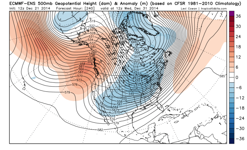
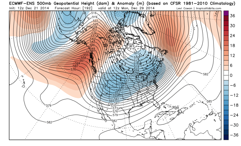
12zECMWF Ensemble Mean progged 500mb patter as we head to the new year still unchanged from previous runs.

December 29 Monday Morning
Image

December 31 Wednesday Morning
Image
0 likes   
The following post is NOT an official forecast and should not be used as such. It is just the opinion of the poster and may or may not be backed by sound meteorological data. It is NOT endorsed by any professional institution including storm2k.org For Official Information please refer to the NHC and NWS products.

User avatar
Portastorm
Storm2k Moderator
Storm2k Moderator
Posts: 9914
Age: 63
Joined: Fri Jul 11, 2003 9:16 am
Location: Round Rock, TX
Contact:

#1042 Postby Portastorm » Sun Dec 21, 2014 6:55 pm

The Portastorm Weather Center happily wishes all of you a Happy Winter Solstice! Special wintry/frosty thoughts for wxman57. :wink:
0 likes   
Any forecasts under my name are to be taken with a grain of salt. Get your best forecasts from the National Weather Service and National Hurricane Center.

User avatar
JDawg512
Category 5
Category 5
Posts: 1077
Age: 45
Joined: Mon Aug 26, 2013 8:56 pm
Location: Austin
Contact:

Re: Texas Winter 2014-2015

#1043 Postby JDawg512 » Sun Dec 21, 2014 7:28 pm

Happy Winter Solstice to all!!!
0 likes   
Resident Rain Miser

I am a weather hobbyist living 3.5 miles south of Downtown Austin and in no way or fashion should anything I say concerning forecasts be taken seriously. Please check your local NWS for accurate weather forecasting and conditions.

User avatar
Ntxw
Storm2k Moderator
Storm2k Moderator
Posts: 22786
Joined: Wed Oct 21, 2009 6:34 pm
Location: DFW, Texas

#1044 Postby Ntxw » Sun Dec 21, 2014 7:42 pm

GFS now has low 40s at the surface, very cold aloft below 0 to -2C at 850mb and thickness at or below 540 for Tuesday in W/NW, NC, and NE Texas Tuesday into Weds. Very strong deepening storm over our heads. I wouldn't be shocked if this became a changeable, difficult forecast the next 48-72 hours.Soundings from the GFS dendritic growth is very good in a deep layer, the caveat is the model has the air near the surface above freezing.
0 likes   
The above post and any post by Ntxw is NOT an official forecast and should not be used as such. It is just the opinion of the poster and may or may not be backed by sound meteorological data. It is NOT endorsed by any professional institution including Storm2k. For official information, please refer to NWS products.

  Help support Storm2K!
Help Support Storm2K

aggiecutter
Category 5
Category 5
Posts: 1753
Joined: Thu Oct 14, 2004 9:22 pm
Location: Texarkana

Re:

#1045 Postby aggiecutter » Sun Dec 21, 2014 8:50 pm

Ntxw wrote:GFS now has low 40s at the surface, very cold aloft below 0 to -2C at 850mb and thickness at or below 540 for Tuesday in W/NW, NC, and NE Texas Tuesday into Weds. Very strong deepening storm over our heads. I wouldn't be shocked if this became a changeable, difficult forecast the next 48-72 hours.Soundings from the GFS dendritic growth is very good in a deep layer, the caveat is the model has the air near the surface above freezing.


18z GFS says snow for the Dallas-Ft. Worth metroplex on Tuesday:

Image
0 likes   

User avatar
SouthernMet
Category 3
Category 3
Posts: 857
Joined: Sun Aug 29, 2010 8:23 pm
Location: fort worth, tx

Re: Re:

#1046 Postby SouthernMet » Sun Dec 21, 2014 9:20 pm

Yup for the 1st time now gfs had caught on, & sref trended colder. (nam still has sfc temps above freezing fwiw)

dendrict growth zone looks solid on the sref too.
0 likes   
Nothing that SouthernMet posts, is an official forecast,nor does it reflect views of STORM2K.. SouthernMet is just adding to the great discussions on STORM2K.. Refer to NWS for official forecasts.

Ntxwx
Tropical Storm
Tropical Storm
Posts: 153
Joined: Tue Jan 26, 2010 10:43 am
Location: Bridgeport, Texas

Re: Texas Winter 2014-2015

#1047 Postby Ntxwx » Mon Dec 22, 2014 12:00 am

Im not too familiar with TwisterData.. The 00z GFS shows snow accumulations again for DFW but the NAM & others don't? I thought it was suppose to stay in the upper 30's...
0 likes   

weatherdude1108
Category 5
Category 5
Posts: 4228
Joined: Tue Dec 13, 2011 1:04 pm
Location: Northwest Austin/Cedar Park, TX

#1048 Postby weatherdude1108 » Mon Dec 22, 2014 12:02 am

HAPPY WINTER SOLSTICE everyone!! :cheesy:
0 likes   

Ralph's Weather
S2K Supporter
S2K Supporter
Posts: 3269
Age: 38
Joined: Fri Dec 13, 2013 11:55 am
Location: Lindale, TX
Contact:

#1049 Postby Ralph's Weather » Mon Dec 22, 2014 12:04 am

Tuesday could be a lot like the mid Nov snow with a light band moving from between Midland and the Panhandle east across North Texas and into Northeast Texas. The models are finally picking up on it, but it is very doubtful they have this small system figured out yet. It has been over a month since our last chance for snow so I am sure we will all be watching this closely.
0 likes   
Follow on Facebook at Ralph's Weather.

Ntxwx
Tropical Storm
Tropical Storm
Posts: 153
Joined: Tue Jan 26, 2010 10:43 am
Location: Bridgeport, Texas

Re:

#1050 Postby Ntxwx » Mon Dec 22, 2014 12:34 am

Ralph's Weather wrote:Tuesday could be a lot like the mid Nov snow with a light band moving from between Midland and the Panhandle east across North Texas and into Northeast Texas. The models are finally picking up on it, but it is very doubtful they have this small system figured out yet. It has been over a month since our last chance for snow so I am sure we will all be watching this closely.


How is the GFS showing snow accumulations with surface temps in the 40's?
0 likes   

Ralph's Weather
S2K Supporter
S2K Supporter
Posts: 3269
Age: 38
Joined: Fri Dec 13, 2013 11:55 am
Location: Lindale, TX
Contact:

Re: Re:

#1051 Postby Ralph's Weather » Mon Dec 22, 2014 12:47 am

Ntxwx wrote:How is the GFS showing snow accumulations with surface temps in the 40's?

Not sure will have to study it in the morning, I did see sub freezing temps at 850mb on there.
0 likes   

User avatar
TeamPlayersBlue
Category 5
Category 5
Posts: 3445
Joined: Tue Feb 02, 2010 1:44 am
Location: Denver/Applewood, CO

#1052 Postby TeamPlayersBlue » Mon Dec 22, 2014 2:35 am

Well all the models certainly lost the cold air. Interesting. Also, i think a while back the models saw this HUGE cutoff low that the GFS and Euro are seeing. Kind of interesting.
0 likes   
Personal Forecast Disclaimer:
The posts in this forum are NOT official forecast and should not be used as such. They are just the opinion of the poster and may or may not be backed by sound meteorological data. They are NOT endorsed by any professional institution or storm2k.org. For official information, please refer to the NHC and NWS products.

Ntxwx
Tropical Storm
Tropical Storm
Posts: 153
Joined: Tue Jan 26, 2010 10:43 am
Location: Bridgeport, Texas

Re: Texas Winter 2014-2015

#1053 Postby Ntxwx » Mon Dec 22, 2014 7:48 am

Can I get a Pro met, or someone knowledgeable that can explain to me why this won't happen tomorrow? http://www.twisterdata.com/index.php?pr ... hive=false
0 likes   

Ralph's Weather
S2K Supporter
S2K Supporter
Posts: 3269
Age: 38
Joined: Fri Dec 13, 2013 11:55 am
Location: Lindale, TX
Contact:

Re: Texas Winter 2014-2015

#1054 Postby Ralph's Weather » Mon Dec 22, 2014 8:41 am

Ntxwx wrote:Can I get a Pro met, or someone knowledgeable that can explain to me why this won't happen tomorrow? http://www.twisterdata.com/index.php?pr ... hive=false

Def not a pro, but this is a very intriguing situation. All models show 850mb temps around or below freezing, but they show surface temps around 40. The models vary on precip qpf with the GFS being the heaviest so that could be why it is showing snow. Seems like a situation where if the precip comes down heavy we could get wet snow flakes and otherwise just light rain.
0 likes   
Follow on Facebook at Ralph's Weather.

User avatar
srainhoutx
S2K Supporter
S2K Supporter
Posts: 6919
Age: 67
Joined: Sun Jan 14, 2007 11:34 am
Location: Haywood County, NC
Contact:

Re: Texas Winter 2014-2015

#1055 Postby srainhoutx » Mon Dec 22, 2014 8:44 am

Ntxwx wrote:Can I get a Pro met, or someone knowledgeable that can explain to me why this won't happen tomorrow? http://www.twisterdata.com/index.php?pr ... hive=false


The surface column is projected to be too dry up to about 5000 feet. Now that said it is possible some light flurries could make it to the surface. Each model run has trended stronger with the shortwave in the Southern Rockies and as seen in the Northern and Central Mountains of New Mexico, Winter Weather Advisories were changed to Winter Storm Warnings and the Panhandles of Texas/ Oklahoma have issued Special Weather Statements regarding some potential for light snow.
Last edited by srainhoutx on Mon Dec 22, 2014 9:10 am, edited 1 time in total.
0 likes   
Carla/Alicia/Jerry(In The Eye)/Michelle/Charley/Ivan/Dennis/Katrina/Rita/Wilma/Ike/Harvey

Member: National Weather Association
Wx Infinity Forums
http://wxinfinity.com/index.php

Facebook.com/WeatherInfinity
Twitter @WeatherInfinity

User avatar
Portastorm
Storm2k Moderator
Storm2k Moderator
Posts: 9914
Age: 63
Joined: Fri Jul 11, 2003 9:16 am
Location: Round Rock, TX
Contact:

Re: Texas Winter 2014-2015

#1056 Postby Portastorm » Mon Dec 22, 2014 8:50 am

Ralph's Weather wrote:
Ntxwx wrote:Can I get a Pro met, or someone knowledgeable that can explain to me why this won't happen tomorrow? http://www.twisterdata.com/index.php?pr ... hive=false

Def not a pro, but this is a very intriguing situation. All models show 850mb temps around or below freezing, but they show surface temps around 40. The models vary on precip qpf with the GFS being the heaviest so that could be why it is showing snow. Seems like a situation where if the precip comes down heavy we could get wet snow flakes and otherwise just light rain.


As stated in the morning AFD out of DFW, the middle and lower levels of your airmass will be too dry to support the nutty amounts the 6z GFS is showing. It also looks like the 6z run is progging a strong vortmax down the back side of the trough when the air column (if it was mostly or entirely saturated) would support snow temperature wise. While it's exciting to see, I wouldn't count on it if I were you.

Now ... tonight ... if short range models like the SREF and the HRRR are showing this, that's a different story.
0 likes   
Any forecasts under my name are to be taken with a grain of salt. Get your best forecasts from the National Weather Service and National Hurricane Center.

Ralph's Weather
S2K Supporter
S2K Supporter
Posts: 3269
Age: 38
Joined: Fri Dec 13, 2013 11:55 am
Location: Lindale, TX
Contact:

#1057 Postby Ralph's Weather » Mon Dec 22, 2014 8:58 am

This is when mets make their money. The most likely scenario is 40s and light rain, but then again leading up to this forecasts have been calling for 50s. If the lower levels can moisten and this storm is as strong as some models are indicating we could see mid 30s and snow with a forecast of 50s and rain.
0 likes   
Follow on Facebook at Ralph's Weather.

User avatar
wxman57
Moderator-Pro Met
Moderator-Pro Met
Posts: 22980
Age: 67
Joined: Sat Jun 21, 2003 8:06 pm
Location: Houston, TX (southwest)

Re: Re:

#1058 Postby wxman57 » Mon Dec 22, 2014 9:08 am

Ntxwx wrote:How is the GFS showing snow accumulations with surface temps in the 40's?


The answer is that the algorithm in the GFS for differentiating rain from snow accumulations is probably not capturing this setup properly. The 6Z GFS (same run pointed out above with 1" snow) is forecasting temps in the mid to upper 40s tomorrow at the surface and temps aloft (850mb / 5000ft) approaching freezing as the precip ends.

Image

But look at the plot of the projected upper-air pattern during the precip (below). While the temperature from the surface to around 5000 ft is ABOVE freezing, the temperature above 5000 ft (850mb) is all below freezing. And look where the red & green lines (temp & dewpoint) are touching above 850mb. That's where the precip is falling from (700mb/10,000ft to 400mb). The GFS is forecasting the precip to fall as snow from about 10,000-15,000ft up and make it to the ground AND accumulate. Of course, with surface temps in the mid 40s any snow reaching the ground would immediately melt. It's going to be difficult for any snow to reach the ground there in Dallas with such warm temps in the lower 5000 ft. But it's not impossible to see some snow flurries with temps in the mid 40s.

Image
0 likes   

User avatar
TeamPlayersBlue
Category 5
Category 5
Posts: 3445
Joined: Tue Feb 02, 2010 1:44 am
Location: Denver/Applewood, CO

#1059 Postby TeamPlayersBlue » Mon Dec 22, 2014 9:45 am

So nat gas futures are down almost 8% today, i think alot of people saw the models drop the cold air yesterday, i hope that the models catch onto them again :)
0 likes   
Personal Forecast Disclaimer:
The posts in this forum are NOT official forecast and should not be used as such. They are just the opinion of the poster and may or may not be backed by sound meteorological data. They are NOT endorsed by any professional institution or storm2k.org. For official information, please refer to the NHC and NWS products.

Ralph's Weather
S2K Supporter
S2K Supporter
Posts: 3269
Age: 38
Joined: Fri Dec 13, 2013 11:55 am
Location: Lindale, TX
Contact:

Re:

#1060 Postby Ralph's Weather » Mon Dec 22, 2014 9:55 am

TeamPlayersBlue wrote:So nat gas futures are down almost 8% today, i think alot of people saw the models drop the cold air yesterday, i hope that the models catch onto them again :)

I am sure they will. Sometimes I think the models like to toy with us. Next week should be cold, but nothing that we don't see most years. The snow potential is what could make it memorable. I remember a widespread 4-6" snow storm on New Year's night about 15 years ago across North and Northeast Texas.
0 likes   
Follow on Facebook at Ralph's Weather.


Return to “Winter Weather”

Who is online

Users browsing this forum: No registered users and 3 guests